List of Indiana state parks

Last updated

The U.S. state of Indiana has 24 state parks maintained and operated by Indiana Department of Natural Resources (DNR). [1] In addition, a separate state agency operates White River State Park in downtown Indianapolis. [2] Marion and Clark are the only counties to have two parks. Brown County, the largest state park, has the greatest number of visitors, followed by Indiana Dunes State Park. [1]

Contents

Richard Lieber was instrumental in the foundation of the Indiana State Park system. The first state park in Indiana was McCormick's Creek State Park, in Owen County in 1916, followed in the same year by Turkey Run State Park in Parke County. The number of state parks rose steadily in the 1920s, mostly by donations of land from local authorities to the state government. Of the initial twelve parks, only Muscatatuck State Park is no longer a state park, having been given back to Jennings County in 1968. [3] It was during the Great Depression of the 1930s that much infrastructure was built within the parks, constructed by New Deal agencies such as the Civilian Conservation Corps and the Works Progress Administration, with the majority of this Depression-era construction still in use in the 21st century. This delay in infrastructure was due in part to Richard Lieber's belief that the parks should be kept as natural as possible. [4]

Initially, the state parks were intended to feature natural environments in Indiana. The establishment of Mounds State Park for its historical nature and Shakamak State Park (an abandoned strip mine) purely for recreational purposes represented changes from the initial purposes of the Indiana state park system. [5]

While Indiana does not have as many state parks as some other states, it has avoided obtaining too many smaller properties that would be hard to manage. A goal of having at least one state park within an hour's drive for every Hoosier was met when Prophetstown State Park was established in 2004. [6]

It is possible to view the Milky Way at 3 of the 24 Indiana State Parks, [7] which are Shades State Park, Tippecanoe River State Park, and Turkey Run State Park.

State parks

Park NameImageCityCounty or CountiesYear EstablishedSize [8] Remarks [8]
Brown County Brown-County-Szmurlo.jpg Nashville
39°07′N86°16′W / 39.11°N 86.26°W / 39.11; -86.26 (Brown County)
Brown 192915,776 acres (63.84 km2)Largest State Park in Indiana [9]
Chain O' Lakes Stanley School at Chain O'Lakes.jpg Albion
41°20′N85°23′W / 41.33°N 85.38°W / 41.33; -85.38 (Chain O'Lakes)
Noble 19602,718 acres (11.00 km2)Features eight connected kettle lakes [10]
Charlestown Fourteen Mile Creek waterfront.jpg Charlestown
38°26′N85°38′W / 38.43°N 85.63°W / 38.43; -85.63 (Charlestown)
Clark 19965,100 acres (21 km2)Built on the grounds of the old Indiana Army Ammunition Plant [11]
Clifty Falls Clifty Falls at Clifty Falls State Park.JPG Madison
38°46′N85°25′W / 38.76°N 85.42°W / 38.76; -85.42 (Clifty Falls)
Jefferson 19201,416 acres (5.73 km2)Features a canyon that has daylight only at midday [12]
Falls of the Ohio Fossil beds on the Ohio River.JPG Clarksville
38°16′37″N85°45′47″W / 38.277°N 85.763°W / 38.277; -85.763 (Falls of the Ohio)
Clark 1990165 acres (0.67 km2)Offers views of the Falls of the Ohio and Louisville, Kentucky [13]
Fort Harrison Fort Ben - Fall Creek Boardwalk.jpg Indianapolis
39°52′N86°01′W / 39.87°N 86.01°W / 39.87; -86.01 (Fort Harrison)
Marion 19961,700 acres (6.9 km2)Built on the site of old Fort Benjamin Harrison [14]
Harmonie
New Harmony
38°04′N87°57′W / 38.06°N 87.95°W / 38.06; -87.95 (Harmonie)
Posey 19663,465 acres (14.02 km2)Near historic Rappite and Owenite villages. [15]
Indiana Dunes Indiana Dunes-State-Park-02.jpg Porter
41°40′N87°02′W / 41.66°N 87.04°W / 41.66; -87.04 (Indiana Dunes)
Porter 19252,182 acres (8.83 km2)Attached to Indiana Dunes National Park. [16]
Lincoln Lincoln state part1.jpg Lincoln City
38°06′N87°00′W / 38.10°N 87.00°W / 38.10; -87.00 (Lincoln)
Spencer 19321,847 acres (7.47 km2)Across from Lincoln Boyhood National Memorial, it was the last state park established by Richard Lieber. [17]
McCormick's Creek McCormicks Creek falls Indiana.JPG Spencer
39°17′N86°44′W / 39.29°N 86.73°W / 39.29; -86.73 (McCormick's Creek)
Owen 19161,924 acres (7.79 km2)First state park in Indiana [18]
Mounds MoundsHouse.jpg Anderson
40°06′N85°37′W / 40.10°N 85.62°W / 40.10; -85.62 (Mounds)
Madison 1930290 acres (1.2 km2) [19]
O'Bannon Woods O'Bannon Woods Entrance.jpg Corydon
38°11′N86°17′W / 38.18°N 86.29°W / 38.18; -86.29 (O'Bannon Woods)
Harrison 20042,000 acres (8.1 km2)Formerly the Wyandotte SRA, renamed in honor of the late Indiana governor Frank O'Bannon. [20]
Ouabache
Bluffton
40°43′N85°07′W / 40.72°N 85.11°W / 40.72; -85.11 (Ouabache)
Wells 19621,104 acres (4.47 km2)Name comes from the French spelling of "Wabash" [21]
Pokagon Potawatomi Inn Pokagon State Park.jpg Angola
41°43′N85°01′W / 41.71°N 85.02°W / 41.71; -85.02 (Pokagon)
Steuben 19251,260 acres (5.1 km2)Well known for its skiing. [22]
Potato Creek
North Liberty
41°33′N86°20′W / 41.55°N 86.34°W / 41.55; -86.34 (Potato Creek)
St. Joseph 19693,840 acres (15.5 km2) [23]
Prophetstown Prophetstown State Park.jpg West Lafayette
40°30′N86°50′W / 40.50°N 86.83°W / 40.50; -86.83 (Prophetstown)
Tippecanoe 20042,000 acres (8.1 km2) [24]
Shades Deer Mill Covered Bridge Indiana 4.jpg Waveland
39°56′N87°05′W / 39.93°N 87.08°W / 39.93; -87.08 (Shades)
Montgomery 19473,082 acres (12.47 km2)Only state park to ever have its own airstrip. [25]
Shakamak Shakamak Nature Center 181.jpg Jasonville
39°10′N87°14′W / 39.17°N 87.24°W / 39.17; -87.24 (Shakamak)
Clay, Greene and Sullivan 19291,766 acres (7.15 km2)Used to be a strip mine [26]
Spring Mill Spring Mill Gristmill.jpg Mitchell
38°44′N86°25′W / 38.73°N 86.42°W / 38.73; -86.42 (Spring Mill)
Lawrence 19271,358 acres (5.50 km2)Featured a pioneer village, numerous caves, and a memorial to Gus Grissom [27]
Summit Lake SummitLakeStatePark.jpg New Castle
40°02′N85°18′W / 40.03°N 85.30°W / 40.03; -85.30 (Summit Lake)
Henry 19882,680 acres (10.8 km2) [28]
Tippecanoe River Tippecanoe R SP Indiana TheRiver P1300080.jpg Winamac
41°09′N86°36′W / 41.15°N 86.60°W / 41.15; -86.60 (Tippecanoe River)
Pulaski 19432,761 acres (11.17 km2) [29]
Turkey Run Turkey Run SP, IN 4.jpg Marshall
39°53′N87°13′W / 39.88°N 87.21°W / 39.88; -87.21 (Turkey Run)
Parke 19162,382 acres (9.64 km2)Famous for its sandstone gorges and unique terrain [30]
Versailles 036 34A Busching, Versailles SP, Versailles Cty.jpg Versailles
39°05′N85°14′W / 39.08°N 85.23°W / 39.08; -85.23 (Versailles)
Ripley 19435,988 acres (24.23 km2) [31]
White River C4241-Indianapolis-Canal.jpg Indianapolis
39°46′N86°10′W / 39.77°N 86.17°W / 39.77; -86.17 (White River)
Marion 1979250 acres (1.0 km2)An urban park in downtown Indianapolis [32]
Whitewater Memorial Whitewatersign.jpg Liberty
39°37′N84°58′W / 39.61°N 84.97°W / 39.61; -84.97 (Whitewater Memorial)
Union 19491,710 acres (6.9 km2)Built on land donated by four counties [33]

See also

Related Research Articles

<span class="mw-page-title-main">Wabash River</span> Tributary of the Ohio River in the United States

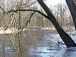
The Wabash River is a 503-mile-long (810 km) river that drains most of the state of Indiana in the United States. It flows from the headwaters in Ohio, near the Indiana border, then southwest across northern Indiana turning south near the Illinois border, where the southern portion forms the Indiana-Illinois border before flowing into the Ohio River.

<span class="mw-page-title-main">White River (Indiana)</span> River in Indiana, United States

The White River is an American two-forked river that flows through central and southern Indiana and is the main tributary to the Wabash River. Via the west fork, considered to be the main stem of the river by the U.S. Board on Geographic Names, the White River is 362 miles (583 km) long. Indiana's capital, Indianapolis, is located on the river. The two forks meet just north of Petersburg and empty into the Wabash River at Mount Carmel, Illinois.

<span class="mw-page-title-main">Turkey Run State Park</span> State park and historic place in Indiana, U.S.

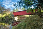
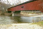
Turkey Run State Park, Indiana's second state park, is in Parke County in the west-central part of the state along State Road 47, 2 miles (3.2 km) east of U.S. 41.

<span class="mw-page-title-main">McCormick's Creek State Park</span> State park in Owen County, Indiana

McCormick's Creek State Park is the oldest state park in the U.S. state of Indiana, dedicated on July 4, 1916, as part of the state's centennial celebration. It is located 14 miles (23 km) west of Bloomington in Owen County. The park receives about 640,000 visitors annually.

<span class="mw-page-title-main">Prophetstown State Park</span> State park in Indiana, United States

Prophetstown State Park commemorates a Native American village founded in 1808 by Shawnee leaders Tecumseh and his brother Tenskwatawa north of present-day Lafayette, Indiana, which grew into a large, multi-tribal community. The park features an open-air museum at Prophetstown, with living history exhibits including a Shawnee village and a 1920s-era farmstead. Battle Ground, Indiana, is a village about a mile east of the site of the Battle of Tippecanoe in 1811, a crucial battle in Tecumseh's War which ultimately led to the demise of Prophetstown. The state park was established in 2004 and receives about 335,000 visitors annually.

<span class="mw-page-title-main">Clifty Falls State Park</span> State park in Indiana, United States

Clifty Falls State Park is an Indiana state park on 1,416 acres (573 ha) in Jefferson County, Indiana in the United States. It is 46 miles (74 km) northeast of Louisville, Kentucky. The park attracts about 370,000 visitors annually.

<span class="mw-page-title-main">Shakamak State Park</span> State park in Indiana, United States

Shakamak State Park is a state park in Indiana, United States. It is located 30 miles (48 km) southeast of Terre Haute, Indiana.

<span class="mw-page-title-main">O'Bannon Woods State Park</span> State park in Harrison County, Indiana

O'Bannon Woods State Park is a 2,000-acre (8 km2) state park in the state of Indiana, 32 miles (51 km) west of Louisville, Kentucky.

<span class="mw-page-title-main">Fort Harrison State Park</span> State park in Lawrence, Indiana, U.S.

Fort Harrison, sometimes called Fort Ben, is an Indiana state park located in Lawrence, Indiana, United States, and occupies part of the former site of Fort Benjamin Harrison. The park features a former Citizen's Military Training Camp, Civilian Conservation Corps camp, and World War II prisoner of war camp. There are also picnicking and walking/jogging trails including a connection to the Fall Creek Greenway. The park receives nearly 900,000 visitors annually.

<span class="mw-page-title-main">Ouabache State Park</span> State park in Indiana, United States

Ouabache [oʊ'bɑːtʃi] is a state park in Indiana. It is located 30 miles (48 km) south of Fort Wayne, Indiana near Bluffton, Indiana. It was originally the Wells County State Forest and Game Preserve, formed in the early 1930s. In 1962. it became the Ouabache State Recreation Area, before finally achieving state park status in 1983.

<span class="mw-page-title-main">Tippecanoe River State Park</span> State park in Pulaski County, Indiana

Tippecanoe River is a state park in Pulaski County, Indiana, United States. It is located 58 miles (93 km) south-southwest of South Bend, Indiana. It was formed in 1943 when the National Park Service gifted the land to Indiana's Department of Conservation land to form a state park; other land along the river becoming the Winamac Fish and Wildlife Area.

<span class="mw-page-title-main">Versailles State Park</span> State park in Ripley County, Indiana

Versailles State Park is an Indiana state park, near the town of Versailles, Indiana in Ripley County. The land was given by the National Park Service for use as a state park to Indiana's Department of Conservation in 1943. The park draws about 225,000 visitors annually.

<span class="mw-page-title-main">Whitefish Dunes State Park</span> State park in Wisconsin, United States

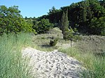
Whitefish Dunes State Park is a 867-acre (351 ha) state park of Wisconsin on the eastern shore of the Door Peninsula. This day-use park preserves the most substantial sand dunes on the western shore of Lake Michigan. The remains of eight successive prehistoric Native American villages are on the National Register of Historic Places as Whitefish Dunes-Bay View Site. Cave Point County Park is an enclave inside the state park, allowing visitors free foot access to the state park by the shoreline trail connecting the parks.

<span class="mw-page-title-main">Geography of Indiana</span> Overview of the geography of Indiana

The geography of Indiana comprises the physical features of the land and relative location of U.S. State of Indiana. Indiana is in the north-central United States and borders on Lake Michigan. Surrounding states are Michigan to the north and northeast, Illinois to the west, Kentucky to the south, and Ohio to the east. The entire southern boundary is the Ohio River.

<span class="mw-page-title-main">Hardy Lake</span> Reservoir in Indiana, United States

Hardy Lake, originally named Quick Creek Reservoir, is an Indiana state reservoir in Scott and Jefferson counties, Indiana. It is located four miles (6 km) east of Austin, Indiana and 35 miles (56 km) north of Louisville, Kentucky. It is the smallest reservoir maintained by the state of Indiana, measuring 2,448 acres (9.9 km2) of total property, and 741 acres (3.0 km2) of surface area for the lake. The lake is approximately 38 feet (12 m) deep.

<span class="mw-page-title-main">Gunpowder Falls State Park</span> State park in Maryland, United States

Gunpowder Falls State Park is a public recreation area comprising six non-contiguous areas covering 18,000 acres (7,300 ha) in northeastern Baltimore County and western Harford County, Maryland. The state park is primarily made up of the stream valleys of the Big and Little Gunpowder Falls and the Gunpowder River; its natural features range from tidal marshes to rugged interior slopes. The park has over 120 miles of trails for hiking, biking, horseback riding, and cross-country skiing plus facilities for picnicking, tubing, canoeing and kayaking, tide-water fishing and crabbing, fly fishing, and hunting, among other activities. It is managed by the Maryland Department of Natural Resources.

References

  1. 1 2 "DNR: State Parks: Find a Park". Indiana Department of Natural Resources. Retrieved March 28, 2010.
  2. "White River State Park". in.gov. State of Indiana. Archived from the original on September 4, 2014. Retrieved September 3, 2014.
  3. History Archived 2008-05-09 at the Wayback Machine
  4. Ralston, Patrick. New Deal Resources in Indiana State Parks MPS
  5. Ralston
  6. DNR - State Parks & Reservoirs: History & Culture
  7. R, Mike (August 13, 2021). "State Parks Light Pollution Map And Statistics". CosmosPNW. Retrieved January 16, 2022.
  8. 1 2 "Indiana Recreation Guide 2010" (PDF). Indiana Department of Natural Resources. Archived from the original (PDF) on February 17, 2010. Retrieved March 31, 2010.
  9. "Brown County". Indiana Department of Natural Resources. Retrieved March 28, 2010.
  10. "Chain O' Lakes". Indiana Department of Natural Resources. Retrieved March 28, 2010.
  11. "Charlestown". Indiana Department of Natural Resources. Retrieved March 28, 2010.
  12. "Clifty Falls". Indiana Department of Natural Resources. Retrieved March 28, 2010.
  13. "Falls of the Ohio". Indiana Department of Natural Resources. Retrieved March 28, 2010.
  14. "Fort Harrison". Indiana Department of Natural Resources. Retrieved March 28, 2010.
  15. "Harmonie". Indiana Department of Natural Resources. Retrieved March 28, 2010.
  16. "Indiana Dunes". Indiana Department of Natural Resources. Retrieved March 28, 2010.
  17. "Lincoln". Indiana Department of Natural Resources. Retrieved March 28, 2010.
  18. "McCormick's Creek". Indiana Department of Natural Resources. Retrieved March 28, 2010.
  19. "Mounds". Indiana Department of Natural Resources. Retrieved March 28, 2010.
  20. "O'Bannon Woods". Indiana Department of Natural Resources. Retrieved March 28, 2010.
  21. "Ouabache". Indiana Department of Natural Resources. Retrieved March 28, 2010.
  22. "Pokagon". Indiana Department of Natural Resources. Retrieved March 28, 2010.
  23. "Potato Creek". Indiana Department of Natural Resources. Retrieved March 28, 2010.
  24. "Prophetstown". Indiana Department of Natural Resources. Retrieved March 28, 2010.
  25. "Shades". Indiana Department of Natural Resources. Retrieved March 28, 2010.
  26. "Shakamak". Indiana Department of Natural Resources. Retrieved March 28, 2010.
  27. "Spring Mill". Indiana Department of Natural Resources. Retrieved March 28, 2010.
  28. "Summit Lake". Indiana Department of Natural Resources. Retrieved March 28, 2010.
  29. "Tippecanoe River". Indiana Department of Natural Resources. Retrieved March 28, 2010.
  30. "Turkey Run". Indiana Department of Natural Resources. Retrieved March 28, 2010.
  31. "Versailles". Indiana Department of Natural Resources. Retrieved March 28, 2010.
  32. "White River". White River State Park. Retrieved March 28, 2010.
  33. "Whitewater Memorial". Indiana Department of Natural Resources. Retrieved March 28, 2010.
Map all coordinates using: OpenStreetMap