
Luzon is the largest and most populous island in the Philippines. Located in the northern portion of the Philippines archipelago, it is the economic and political center of the nation, being home to the country's capital city, Manila, as well as Quezon City, the country's most populous city. With a population of 64 million as of 2021, it contains 52.5% of the country's total population and is the fourth most populous island in the world. It is the 15th largest island in the world by land area.

The South China Sea, or South East Asian Sea, is a marginal sea of the Western Pacific Ocean. It is bounded in the north by the shores of South China, in the west by the Indochinese Peninsula, in the east by the islands of Taiwan and northwestern Philippines, and in the south by Borneo, eastern Sumatra and the Bangka Belitung Islands, encompassing an area of around 3,500,000 km2 (1,400,000 sq mi). It communicates with the East China Sea via the Taiwan Strait, the Philippine Sea via the Luzon Strait, the Sulu Sea via the straits around Palawan, the Strait of Malacca via the Singapore Strait, and the Java Sea via the Karimata and Bangka Straits. The Gulf of Thailand and the Gulf of Tonkin are also part of South China Sea. The shallow waters south of the Riau Islands are also known as the Natuna Sea.

Leyte, officially the Province of Leyte, is a province in the Philippines located in the Eastern Visayas region, occupying the northern three-quarters of Leyte Island. Its capital is the city of Tacloban, administered independently from the province. Leyte is situated west of Samar Island, north of Southern Leyte and south of Biliran. To the west across the Camotes Sea is the province of Cebu.

Bataan, officially the Province of Bataan, is a province in the Central Luzon region of the Philippines. Its capital is the city of Balanga while Mariveles is the largest town in the province. Occupying the entire Bataan Peninsula on Luzon, Bataan is bordered by the provinces of Zambales and Pampanga to the north. The peninsula faces the South China Sea to the west and Subic Bay to the north-west, and encloses Manila Bay to the east.
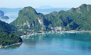
El Nido, officially the Municipality of El Nido, is a 1st class municipality in the province of Palawan, Philippines. According to the 2020 census, it has a population of 50,494 people.

Scarborough Shoal, also known as Bajo de Masinloc, Panatag Shoal, Huangyan Island, and Democracy Reef, are two rocks in a shoal located between Luzon and Macclesfield Bank administrated by China in the South China Sea. It is 220 kilometres (119 nmi) away from the nearest landmass of Luzon, the largest island of the Philippines.

The Subic Special Economic and Freeport Zone, often shorterned as Subic Bay or Subic, is a special economic zone and freeport area covering portions of the city of Olongapo and the town of Subic in Zambales, and the towns of Morong and Hermosa in Bataan. The relatively developed and fenced area is called the Subic Bay Freeport Zone (SBFZ).
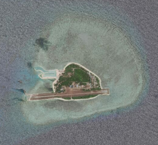
Thitu Island, also known as Pag-asa Island, having an area of 37.2 hectares, is the second largest of the naturally occurring Spratly Islands and the largest of the Philippine-administered islands. It lies about 500 kilometers (310 mi) west of Puerto Princesa. Its neighbors are the North Danger Reef to the north, Subi Reef to the west, and the Loaita and Tizard Banks to the south.
The Philippines has claimed many territories throughout its history. These territories include the Spratly Islands, portions of North Borneo, and the Scarborough Shoal.
The Benham Rise, officially known as Philippine Rise, is an extinct volcanic ridge located in the Philippine Sea approximately 250 kilometers (160 mi) east of the northern coastline of Dinapigue, Isabela. The rise has been known to the people of Catanduanes as Kalipung-awan as early as the precolonial era of the Philippines, which literally means "loneliness from an isolated place".
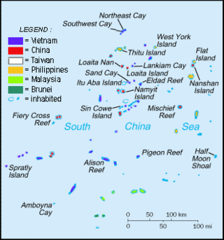
The Spratly Islands dispute is an ongoing territorial dispute between China, the Philippines, Taiwan, Malaysia, Vietnam, and Brunei, concerning "ownership" of the Spratly Islands, a group of islands and associated "maritime features" located in the South China Sea. The dispute is characterized by diplomatic stalemate and the employment of military pressure techniques in the advancement of national territorial claims. All except Brunei occupy some of the maritime features.

Territorial disputes in the South China Sea involve conflicting island and maritime claims in the region by several sovereign states, namely Brunei, the People's Republic of China (PRC), Taiwan, Indonesia, Malaysia, Philippines, and Vietnam. The disputes involve the islands, reefs, banks, and other features of the South China Sea, including the Spratly Islands, Paracel Islands, Scarborough Shoal, and various boundaries in the Gulf of Tonkin. The waters near the Indonesian Natuna Islands, which some regard as geographically part of the South China Sea, are disputed as well. Maritime disputes also extend beyond the South China Sea, as in the case of the Senkaku Islands and the Socotra Rock, which lie in the East China Sea.

West Philippine Sea is the official designation by the government of the Philippines to the parts of the South China Sea that are included in the country's exclusive economic zone. The term is also sometimes incorrectly used to refer to the entire South China Sea.

Relations between People's Republic of China and the Philippines have suffered due to the worsening South China Sea dispute. The current policy of the president of the Philippines aims for distancing relations between the Philippines and China to the benefit of the country's relationship with the United States, while the current policy of the general secretary of the Chinese Communist Party aims for greater influence over the Philippines, and the region in general, while combating American influence.

Philippines v. China, also known as the South China Sea Arbitration, was an arbitration case brought by the Republic of the Philippines against the People's Republic of China (PRC) under Annex VII of the United Nations Convention on the Law of the Sea concerning certain issues in the South China Sea, including the nine-dash line introduced by the Republic of China (Taiwan) since as early as 1947. A tribunal of arbitrators appointed the Permanent Court of Arbitration (PCA) as the registry for the proceedings.

The article covers events that are related to the South China Sea dispute.

BRP Gregorio del Pilar (PS-15) is the lead ship of her class of offshore patrol vessel of the Philippine Navy. She is the second ship to be named after Gregorio del Pilar, a Filipino revolutionary general known for his role at the Battle of Tirad Pass. She was originally designated as "PF-15" from 2012 to mid-2016. Then the Navy adopted a new code designation system and she was redesignated as "FF-15". In February 2019, the Navy downgraded the status of the entire class from frigate to patrol ship and redesignated her to "PS-15".

The Philippines has an exclusive economic zone that covers 2,263,816 square kilometers (874,064 sq mi) of sea. It claims an EEZ of 200 nautical miles (370 km) from its shores. This is due to the 7,641 islands comprising the Philippine archipelago. The total land area, including inland bodies of water, of the Philippines is 300,000 square kilometers (120,000 sq mi). It has the fifth longest coastline in the world with 36,289 kilometers (22,549 mi). The coordinates are between 116° 40', and 126° 34' E longitude and 4° 40' and 21° 10' N latitude. It is bordered by the Philippine Sea to the east and north, the South China Sea to the west, and the Celebes Sea to the south.

The 2019 Reed Bank incident occurred when F/B Gem-Ver, a Philippine fishing boat anchored in Reed Bank in the South China Sea, sank after it was rammed by a Chinese vessel, Yuemaobinyu 42212, during the early morning hours of 9 June 2019. The stricken vessel's crew was later rescued by a Vietnamese fishing vessel.
Malaysia claims an exclusive economic zone (EEZ) of 334,671 km2 (129,217 sq mi) with 200 nautical miles from its shores. The EEZ includes much of the southern area of the South China Sea. Malaysia has the 29th longest coastline of 4,675 km (2,905 mi). The coastline comprises two distinct parts of Malaysia. The Peninsular Malaysia's coastline to the west is 2,068 km (1,285 mi) and East Malaysia's coastline is 2,607 km (1,620 mi). They are separated by the South China Sea. The total land area, including inland bodies of water, of Malaysia is 330,803 km2 (127,724 sq mi). Peninsular Malaysia borders Thailand in the north, while East Malaysia borders Brunei and Indonesia on the island of Borneo.


