See also
Wikimedia Commons has media related to Rivers of Hawaii .
This is a list of rivers and streams in Hawaii (U.S. state).
Modern maps show some 360 streams in the Hawaiian Islands. However, because of the small size of the islands in comparison with continental areas, there are very few navigable rivers anywhere in the islands.
The following list is sorted by name. Click on the double triangles at the top of the "Island" column to sort the table by island.

The term "United States," when used in the geographical sense, refers to the contiguous United States, the state of Alaska, the island state of Hawaii, the five insular territories of Puerto Rico, Northern Mariana Islands, U.S. Virgin Islands, Guam, and American Samoa, and minor outlying possessions. The United States shares land borders with Canada and Mexico and maritime borders with Russia, Cuba, The Bahamas, and other countries, in addition to Canada and Mexico. The northern border of the United States with Canada is the world's longest bi-national land border.

The Owyhee River is a tributary of the Snake River located in northern Nevada, southwestern Idaho and southeastern Oregon in the United States. It is 280 miles (450 km) long. The river's drainage basin is 11,049 square miles (28,620 km2) in area, one of the largest subbasins of the Columbia Basin. The mean annual discharge is 995 cubic feet per second (28.2 m3/s), with a maximum of 50,000 cu ft/s (1,400 m3/s) recorded in 1993 and a minimum of 42 cu ft/s (1.2 m3/s) in 1954.

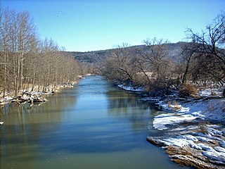
The Wailuku River is a 28.0-mile-long (45.1 km) water course on the Island of Hawaiʻi in the Hawaiian Islands. It is the longest river in Hawai'i and the largest in the state by mean discharge. Its course lies mostly along the divide between the lava flows of Mauna Kea and those of Mauna Loa to the south. It arises at about the 10,800 feet (3,300 m) elevation along the eastern slope of Mauna Kea. It flows generally eastward, descending steeply from the mountain and entering the Pacific Ocean at Hilo.

The Little Osage River is an 88-mile-long (142 km) tributary of the Osage River in eastern Kansas and western Missouri in the United States. Via the Osage and Missouri rivers, it is part of the watershed of the Mississippi River.
Little River is a 23.4-mile-long (37.7 km) tributary stream of Goose Creek in Fauquier and Loudoun counties in northern Virginia. Via Goose Creek, it is a tributary of the Potomac River.
The Cowanesque River is a 41.4-mile-long (66.6 km) tributary of the Tioga River in Potter and Tioga counties, Pennsylvania, and Steuben County, New York, in the United States. It joins the Tioga River soon after crossing from Pennsylvania into New York, near the borough of Lawrenceville, Pennsylvania.
The Mishnock River is a river in the U.S. state of Rhode Island. It flows 3.1 miles (5.0 km). There are two dams along the river's length.
The Kaukonahua Stream or Kaukonahua River is a 9.9-mile-long (15.9 km) river on the island of Oʻahu which is one of the Hawaiian Islands. Including its longer South Fork, the stream's total length is 28.0 miles (45.1 km). It flows down in a generally northwest direction, from 21°30′7″N157°54′13″W into the Pacific Ocean. The North and South forks meet at coordinates 21°29′44″N158°5′50″W. It is the longest river of the whole island group. It empties into Kaiʻaka Bay near Waialua, Hawaii.

The Charlotte River is a tributary of the St. Marys River in the state of Michigan in the United States. The stream is 17.1 miles (27.5 km) long and drains an area of 58.4 square miles (151 km2) on the eastern Upper Peninsula. Via the St. Marys River, it is part of the watershed of Lake Huron. Via Lake Huron and the Great Lakes system, it is part of the larger watershed of the St. Lawrence River.
The Buffalo River is a 4.5-mile-long (7.2 km) tidal river northwest of Brunswick, Georgia. It is part of the Brunswick River network of tidal channels along the Atlantic coast of the U.S. state of Georgia.
There are two streams named the Little Ochlockonee River in southern Georgia in the United States. Both are tributaries of the Ochlockonee River.
The Dead River is a tributary of the Saint George River in the U.S. state of Maine. From the outflow of Newbert Pond in Appleton, the stream runs 3.1 miles (5.0 km) northeast to its confluence with the Saint George River in Searsmont.
The Little Narraguagus River is a short stream in Maine. From the outflow of Bear Pond in Maine Township 28, MD, Hancock County, the river runs 3.3 miles (5.3 km) southeast and east to its confluence with the Narraguagus River in Beddington, Washington County.
The Little River is a 2.1-mile-long (3.4 km) stream and tidal river on Linekin Neck in the town of Boothbay in the U.S. state of Maine. It is a small tidal river for its lower 1.4 miles (2.3 km), entering the Atlantic Ocean just west of the mouth of the Damariscotta River.
The Little Seboeis River is a short stream in Maine Township 4, Range 7, WELS, Penobscot County, Maine. From its source, the river runs 5.5 miles (8.9 km) south and west to its confluence with the Seboeis River.

The Stillwater River is an 11.5-mile-long (18.5 km) side channel of the Penobscot River in Maine. From its source in Old Town, the Stillwater runs 2.3 miles (3.7 km) northwest along the northeast side of Orson Island, the site of the Penobscot Indian Reservation. It then runs 9.2 miles (14.8 km) south along the west sides of Orson and Marsh islands, over three dammed falls. The stream rejoins the main stem of the Penobscot in Orono.
The Lost River is a 31.1-mile-long (50.1 km) river in the Appalachian Mountains of Hardy County in West Virginia's Eastern Panhandle region. The Lost River is geologically the same river as the Cacapon River: It flows into an underground channel northeast of McCauley along West Virginia Route 259 at "the Sinks" and reappears near Wardensville as the Cacapon. The source of the Lost River lies south of Mathias near the West Virginia/Virginia border. Along with the Cacapon and North rivers, the Lost River serves as one of the three main segments of the Cacapon River and its watershed.

Arnold Creek is a tributary of Middle Island Creek, 10.9 miles (17.5 km) long, in West Virginia in the United States. Via Middle Island Creek and the Ohio River, it is part of the watershed of the Mississippi River, draining an area of 34.7 square miles (90 km2) in a rural region on the unglaciated portion of the Allegheny Plateau.

Misteguay Creek is a tributary of the Flint River, 38.4 miles (61.8 km) long, on the central Lower Peninsula of Michigan in the United States. The stream drains an area of 174.4 square miles (452 km2) in predominantly agricultural areas of the Flint/Tri-Cities region. Via the Flint and Shiawassee rivers, it is part of the watershed of the Saginaw River, which flows to Saginaw Bay of Lake Huron. Via Lake Huron and the Great Lakes system, it is part of the larger watershed of the St. Lawrence River.
State of Hawaii | |
|---|---|
Honolulu (capital) | |
| Topics | |
| Society | |
| Main islands | |
| Northwestern Islands | |
| Communities | |
| Counties | |
| Sovereignty Movement | |