List of rivers of Tennessee

Last updated

This is a list of rivers of the U.S. state of Tennessee :

Contents

By drainage basin

This list is arranged by drainage basin, with respective tributaries indented under each larger stream's name. All rivers in Tennessee ultimately flow to the Gulf of Mexico.

Lower Mississippi River Mississippi River mod.png
Lower Mississippi River

Mississippi River drainage basin

Tennessee River drainage basin Tennessee watershed.png
Tennessee River drainage basin
Clinch River drainage basin Clinchrivermap.png
Clinch River drainage basin
Holston River drainage basin Holstonrivermap.png
Holston River drainage basin
Cumberland River drainage basin Cumberland River Watershed.png
Cumberland River drainage basin

Mobile River drainage basin

Alphabetically

  River located partially in another state
River Mouth Length Largest settlementMap
Bald River Tellico River 6 minone (Cherokee National Forest)
Barren Fork Collins River 23.4 mi

(37.7 km)

McMinnville
Beaver Creek Clinch River 44 mi [1] Halls Crossroads
Beech River Tennessee River 38.3 mi

(61.6 km)

Lexington
Big Sandy River Tennessee River 60 mi

(97 km)

Bruceton
Big South Fork of the Cumberland River Cumberland River 76 mi

(122 km)

none (Big South Fork National River and Recreation Area)
Blackburn Fork River Roaring River 14.5 mi [2] none (Cummins Falls State Park)
Blood River Tennessee River Buchanan
Buffalo River Duck River 125 mi

(201 km)

Linden
Calfkiller River Caney Fork River 42.4 mi

(68.2 km)

Sparta
Cane Creek (Caney Fork River tributary) Caney Fork River
Caney Fork River Cumberland River 143 mi

(230 km)

Carthage Caney Fork Watershed Map.png
Clear Fork (Big South Fork Cumberland River tributary) Big South Fork of the Cumberland River 27.2 mi

(43.8 km)

Rugby
Clear Fork (Cumberland River tributary) Cumberland River 42.8 mi

(68.9 km)

Clairfield
Clear Fork (Smith Fork Creek tributary) Smith Fork Creek
Chickamauga Creek Tennessee River Chattanooga
Clinch River Tennessee River 337 mi

(542 km)

Oak Ridge Clinchrivermap.png
Coal Creek Clinch River 10.3 mi

(16.6 km)

Rocky Top
Collins River Caney Fork River 67 mi

(108 km)

Gruetli-Laager
Conasauga Creek Hiwassee River 42.8 mi

(68.9 km)

Coker Creek
Conasauga River Oostanaula River 93 mi

(150 km)

Conasauga (Polk County) Coosaheadwatersmap.png
Cumberland River Ohio River 688 mi

(1107 km)

Nashville Cumberland River Watershed.png
Defeated Creek (Hickman County) Duck River
Defeated Creek (Smith County) Cumberland River Defeated
Doe River Watauga River 6 mi [3] Elizabethton WataugaDoeRiverMap.png
Duck River Tennessee River 284 mi

(457 km)

Columbia Ducktnrivermap.png
East Fork Poplar Creek Poplar Creek Oak Ridge
Elk River (Watauga River tributary) Watauga River Elk Mills
Elk River (Tennessee River tributary) Tennessee River 195 mi

(314 km)

Fayetteville Elktnrivermap.png
Emory River Clinch River 46 mi

(74 km)

Harriman Emoryrivermap.png
Falling Water River Caney Fork River 46.8 mi

(75.3 km)

Cookeville
Flint River Tennessee River 65.7 mi

(105.6 km)

Flintville
Forked Deer River Obion River Dyersburg
French Broad River Tennessee River 219 mi

(352 km)

Knoxville Frenchbroadrivermap.png
Green River Buffalo River 21.1 mi

(34.0 km)

Waynesboro
Harpeth River Cumberland River 115 mi

(185 km)

Franklin
Hatchie River Mississippi River 238 mi

(383 km)

Bolivar
Hickman Creek
Hiwassee River Tennessee River 147 mi

(237 km)

Charleston Hiwasseerivermap.png
Holston River Tennessee River 136 mi

(219 km)

Kingsport Holstonrivermap.png
Indian Creek (Caney Fork River tributary) Caney Fork River Buffalo Valley (Putnam County)
Indian Creek (Tennessee River tributary) Tennessee River Crossroads
Injun Creek Little Pigeon River none (Great Smoky Mountains National Park)
Little Buffalo River Buffalo River Deerfield
Little Doe River Doe River Hampton
Little Duck River Duck River 6.5 mi

(10.5 km)

Manchester
Little Emory River Emory River Coalfield
Little Harpeth River Harpeth River 16.3 mi

(26.2 km)

Brentwood
Little Indian Creek Indian Creek (Caney Fork River tributary)
Little Obed River Obed River 10 mi

(16 km)

Crossville

See also

Related Research Articles

<span class="mw-page-title-main">Elizabethton, Tennessee</span> City in Tennessee, United States

Elizabethton is a city in, and the county seat of Carter County, Tennessee, United States. Elizabethton is the historical site of the first independent American government located west of both the Eastern Continental Divide and the original Thirteen Colonies.

<span class="mw-page-title-main">Tennessee River</span> River in the southeastern United States

The Tennessee River is the largest tributary of the Ohio River. It is approximately 652 miles (1,049 km) long and is located in the southeastern United States in the Tennessee Valley. The river was once popularly known as the Cherokee River, among other names, as the Cherokee people had their homelands along its banks, especially in what are now East Tennessee and northern Alabama. Additionally, its tributary, the Little Tennessee River, flows into it from Western North Carolina and northeastern Georgia, where the river also was bordered by numerous Cherokee towns. Its current name is derived from the Cherokee town, Tanasi, which was located on the Tennessee side of the Appalachian Mountains.

<span class="mw-page-title-main">Cumberland River</span> River in Kentucky and Tennessee, United States

The Cumberland River is a major waterway of the Southern United States. The 688-mile-long (1,107 km) river drains almost 18,000 square miles (47,000 km2) of southern Kentucky and north-central Tennessee. The river flows generally west from a source in the Appalachian Mountains to its confluence with the Ohio River near Paducah, Kentucky, and the mouth of the Tennessee River. Major tributaries include the Obey, Caney Fork, Stones, and Red Rivers.

<span class="mw-page-title-main">Collins River</span> River in Tennessee, United States

The Collins River is a 67-mile-long (108 km) stream in the east-central portion of Middle Tennessee in the United States. It is a tributary of the Caney Fork, and is part of the Cumberland, Ohio and Mississippi watersheds. The river drains the scenic Savage Gulf area, located just below the river's source, and empties into Great Falls Lake at Rock Island State Park.

<span class="mw-page-title-main">Rocky River (Tennessee)</span> River in Tennessee, United States

The Rocky River is a 31.0-mile-long (49.9 km) stream in the east-central portion of Middle Tennessee in the United States. It is a tributary of the Caney Fork River, and is part of the Cumberland, Ohio and Mississippi watersheds. The lower portion of the river is part of the reservoir created by Great Falls Dam, which is located near the river's confluence with the Caney Fork.

<span class="mw-page-title-main">Falling Water River</span> River in Tennessee, United States

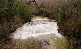
The Falling Water River is a 46.8-mile-long (75.3 km) stream in the east-central portion of Middle Tennessee in the United States. It rises just west of Monterey at the edge of the Cumberland Plateau, and traverses the Eastern Highland Rim before dropping off to the Nashville Basin and emptying into Center Hill Lake along the Caney Fork. The river is noted for the 136-foot (41 m) Burgess Falls, which it spills over near the end of its course.

<span class="mw-page-title-main">Caney Fork River</span> River in Tennessee, United States

The Caney Fork River is a river that flows through central Tennessee in the United States, draining a substantial portion of the southwestern Cumberland Plateau and southeastern Highland Rim regions. It is a major tributary of the Cumberland River, and is part of the Cumberland, Ohio and Mississippi basins. The river is 143 miles (230 km) long, and its watershed covers 1,771 square miles (4,590 km2) in eleven counties. Monterey, Baxter, Sparta, Smithville, McMinnville, Altamont, Spencer and Gordonsville are among the towns that are at least partially drained by the river.

<span class="mw-page-title-main">Fall Creek Falls State Park</span> State park in Tennessee, United States

Fall Creek Falls State Resort Park is a state park in Van Buren and Bledsoe counties, in the U.S. state of Tennessee. The over 30,638-acre (123.99 km2) park is centered on the upper Cane Creek Gorge, an area known for its unique geological formations and scenic waterfalls. The park's namesake is the 256-foot (78 m) Fall Creek Falls, the highest free-fall waterfall east of the Mississippi River.

<span class="mw-page-title-main">Pocket wilderness</span> Type of nature reserve in Tennessee

Pocket wilderness is a name used by Bowater corporation and the State of Tennessee for any of several tracts of Bowater-owned private land on and near the Cumberland Plateau that the company set aside beginning in 1970 "for preservation in its natural state, with no logging or development other than hiking trails permitted within its boundaries" and registered as Tennessee state natural areas. Several areas formerly managed as Bowater pocket wilderness are now incorporated into state-owned natural areas or National Park Service sites.

The cherry darter is a species of freshwater ray-finned fish, a darter from the subfamily Etheostomatinae, part of the family Percidae, which also contains the perches, ruffes and pikeperches. It is endemic to the upper Caney Fork system of the Cumberland River drainage in the U.S. state of Tennessee.

References

  1. Colquit, Elle. "Beaver Creek Water Trail". Outdoor Knoxville. Retrieved 2021-06-16.
  2. "American Whitewater". www.americanwhitewater.org. Retrieved 2021-06-17.
  3. "American Whitewater". www.americanwhitewater.org. Retrieved 2021-06-18.