See also
| Authority control databases: National |
|---|
This is a list of rivers in Indiana (U.S. state).
>
1 Nominally in Illinois, Bonpas creek is now along Indiana-Illinois border due to a shift in the course of the Wabash River.
| Authority control databases: National |
|---|

The Miami are a Native American nation originally speaking one of the Algonquian languages. Among the peoples known as the Great Lakes tribes, they occupied territory that is now identified as north-central Indiana, southwest Michigan, and western Ohio. The Miami were historically made up of several prominent subgroups, including the Piankeshaw, Wea, Pepikokia, Kilatika, Mengakonkia, and Atchakangouen. In modern times, Miami is used more specifically to refer to the Atchakangouen. By 1846, most of the Miami had been forcefully displaced to Indian Territory. The Miami Tribe of Oklahoma are the federally recognized tribe of Miami Indians in the United States. The Miami Nation of Indiana, a nonprofit organization of self-identified descendants of Miamis who were exempted from removal, have unsuccessfully sought separate recognition.

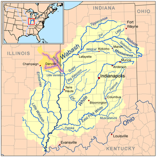
The Wabash River is a 503-mile-long (810 km) river that drains most of the state of Indiana, and a significant part of Illinois, in the United States. It flows from the headwaters in Ohio, near the Indiana border, then southwest across northern Indiana turning south near the Illinois border, where the southern portion forms the Indiana-Illinois border before flowing into the Ohio River.

The White River is an American two-forked river that flows through central and southern Indiana and is the main tributary to the Wabash River. Via the west fork, considered to be the main stem of the river by the U.S. Board on Geographic Names, the White River is 362 miles (583 km) long. Indiana's capital, Indianapolis, is located on the river. The two forks meet just north of Petersburg and empty into the Wabash River at Mount Carmel, Illinois.

The Wabash and Erie Canal was a shipping canal that linked the Great Lakes to the Ohio River via an artificial waterway. The canal provided traders with access from the Great Lakes all the way to the Gulf of Mexico. Over 460 miles long, it was the longest canal ever built in North America.

The Watersheds of Indiana consist of six distinct Indiana watershed regions that drain into five major bodies of water.
The Vermilion River is a tributary of the Wabash River in the states of Illinois and Indiana, United States.

The Flatrock River, also known as Flatrock Creek and other variants of the two names, is a 98-mile-long (158 km) tributary of the East Fork of the White River in east-central Indiana in the United States. Via the White, Wabash and Ohio rivers, it is part of the watershed of the Mississippi River, draining an area of 532 square miles (1,380 km2).
The Mississinewa River is a tributary of the Wabash River in eastern Indiana and a small portion of western Ohio in the United States. It is 120 miles (190 km) long and is the third largest tributary behind the White and Little Wabash Rivers, only slightly larger than the Embarras and Vermilion Rivers. Via the Wabash and Ohio rivers, it is part of the Mississippi River watershed.
The Driftwood River is a 15.5-mile-long (24.9 km) tributary of the East Fork of the White River in central Indiana in the United States. Via the White, Wabash and Ohio rivers, it is part of the watershed of the Mississippi River. It is a short river, formed by the confluence of two longer streams a short distance upstream of its mouth.
Salt Creek may refer to:
Watersheds of Illinois is a list of basins or catchment areas into which the State of Illinois can be divided based on the place to which water flows.

Northern Indiana is a geographic and cultural region that generally comprises the northern third of the U.S. state of Indiana and borders the states of Illinois to the west, Michigan to the north, and Ohio to the east. Spanning the state's northernmost 26 counties, its main population centers include Northwest Indiana, Michiana, and the Fort Wayne metropolitan area.

The geography of Indiana comprises the physical features of the land and relative location of U.S. State of Indiana. Indiana is in the north-central United States and borders on Lake Michigan. Surrounding states are Michigan to the north and northeast, Illinois to the west, Kentucky to the south, and Ohio to the east. The entire southern boundary is the Ohio River.