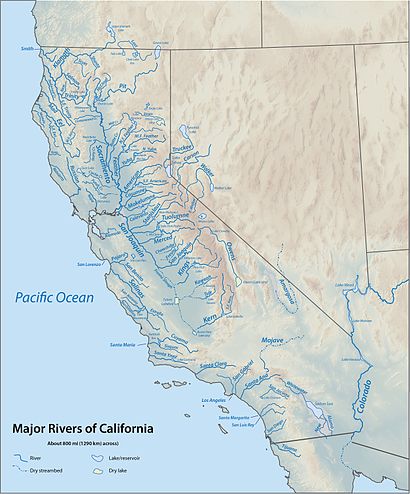
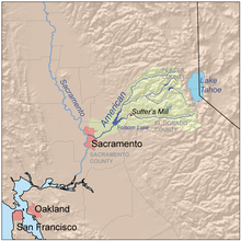
The Kings River, is a 132.9-mile (213.9 km) river draining the Sierra Nevada mountain range in central California in the United States. Its headwaters originate along the Sierra Crest in and around Kings Canyon National Park and form the eponymous Kings Canyon, one of the deepest river gorges in North America. The river is impounded in Pine Flat Lake before flowing into the San Joaquin Valley southeast of Fresno. With its upper and middle course in Fresno County, the Kings River diverges into multiple branches in Kings County, with some water flowing south to the old Tulare Lake bed and the rest flowing north to the San Joaquin River. However, most of the water is consumed for irrigation well upstream of either point.

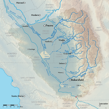
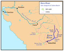
The Kern River, previously Rio de San Felipe, later La Porciuncula, is an Endangered, Wild and Scenic river in the U.S. state of California, approximately 165 miles (270 km) long. It drains an area of the southern Sierra Nevada mountains northeast of Bakersfield. Fed by snowmelt near Mount Whitney, the river passes through scenic canyons in the mountains and is a popular destination for whitewater rafting and kayaking. It is the southernmost major river system in the Sierra Nevada, and is the only major river in the Sierra that drains in a southerly direction.

The Yokuts are an ethnic group of Native Americans native to central California. Before European contact, the Yokuts consisted of up to 60 tribes speaking several related languages. Yokuts is both plural and singular; Yokut, while common, is erroneous. 'Yokut' should only be used when referring specifically to the Tachi Yokut Tribe of Lemoore. Some of their descendants prefer to refer to themselves by their respective tribal names; they reject the term Yokuts, saying that it is an exonym invented by English-speaking settlers and historians. Conventional sub-groupings include the Foothill Yokuts, Northern Valley Yokuts, and Southern Valley Yokuts.

The Kaweah River is a river draining the southern Sierra Nevada in Tulare County, California in the United States. Fed primarily by high elevation snowmelt along the Great Western Divide, the Kaweah begins as four forks in Sequoia National Park, where the watershed is noted for its alpine scenery and its dense concentrations of giant sequoias, the largest trees on Earth. It then flows in a southwest direction to Lake Kaweah – the only major reservoir on the river – and into the San Joaquin Valley, where it diverges into multiple channels across an alluvial plain around Visalia. With its Middle Fork headwaters starting at almost 13,000 feet (4,000 m) above sea level, the river has a vertical drop of nearly two and a half miles (4.0 km) on its short run to the San Joaquin Valley, making it one of the steepest river drainages in the United States. Although the main stem of the Kaweah is only 33.6 miles (54.1 km) long, its total length including headwaters and lower branches is nearly 100 miles (160 km).

The San Jacinto River is a 42-mile-long (68 km) river in Riverside County, California. The river's headwaters are in Santa Rosa and San Jacinto Mountains National Monument. The lower portion of the 765-square-mile (1,980 km2) watershed is urban and agricultural land. As a partially endorheic watershed that is contiguous with other Great Basin watersheds, the western side of the San Jacinto Basin is a portion of the Great Basin Divide.

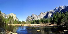
The Fresno River is a river in Central California and a major tributary of the San Joaquin River. It runs approximately 83 miles (134 km) from the Sierra Nevada Range to the San Joaquin River if measured from the source of Rainier Creek, near Raymond Mountain in Yosemite National Park. Although called the 'Fresno' River, it is one of the largest and longest river systems in Madera County.
The Chowchilla River is a river in central California, United States and a minor tributary of the San Joaquin River. It flows for 54.2 miles (87.2 km) from the western side of the Sierra Nevada Range to the San Joaquin River system in the San Joaquin Valley.

Tujunga Wash is a 13-mile-long (20.9 km) stream in Los Angeles County, California. It is a tributary of the Los Angeles River, providing about a fifth of its flow, and drains about 225 square miles (580 km2). It is called a wash because it is usually dry, especially the lower reaches, only carrying significant flows during and after storms, which usually only occur between November and April. The name of the wash derives from a Tongva village name.

The Rio Chama, a major tributary river of the Rio Grande, is located in the U.S. states of Colorado and New Mexico. The river is about 130 miles (210 km) long altogether. From its source to El Vado Dam its length is about 50 miles (80 km), from El Vado Dam to Abiquiu Dam is about 51 miles (82 km), and from Abiquiu Dam to its confluence with the Rio Grande is about 34 miles (55 km).

The Los Gatos Creek runs 24 miles (39 km) in California through Santa Clara Valley Water District's Guadalupe Watershed from the Santa Cruz Mountains northward through the Santa Clara Valley until its confluence with the Guadalupe River in downtown San Jose. The Guadalupe River then continues onward into San Francisco Bay.

San Diego Creek is a 16-mile (26 km) urban waterway flowing into Upper Newport Bay in Orange County, California in the United States. Its watershed covers 112.2 square miles (291 km2) in parts of eight cities, including Irvine, Tustin, and Costa Mesa. From its headwaters in Laguna Woods the creek flows northwest to its confluence with Peters Canyon Wash, where it turns abruptly southwest towards the bay. Most of the creek has been converted to a concrete flood control channel, but it also provides important aquatic and riparian habitat along its course and its tidal estuary.
The Stockton–Los Angeles Road, also known as the Millerton Road, Stockton–Mariposa Road, Stockton–Fort Miller Road or the Stockton–Visalia Road, was established about 1853 following the discovery of gold on the Kern River in Old Tulare County. This route between Stockton and Los Angeles followed by the Stockton–Los Angeles Road is described in "Itinerary XXI. From Fort Yuma to Benicia, California", in The Prairie Traveler: A Hand-book for Overland Expeditions by Randolph Barnes Marcy. The Itinerary was derived from the report of Lieutenant R. S. Williamson on his topographical survey party in 1853, that was in search of a railroad route through the interior of California.

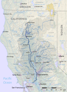
Cottonwood Creek is a major stream and tributary of the Sacramento River in Northern California. About 68 miles (109 km) long measured to its uppermost tributaries, the creek drains a large rural area bounded by the crest of the Coast Ranges, traversing the northwestern Sacramento Valley before emptying into the Sacramento River near the town of Cottonwood. It defines the boundary of Shasta and Tehama counties for its entire length. Because Cottonwood Creek is the largest undammed tributary of the Sacramento River, it is known for its Chinook salmon and steelhead runs.