The Potomac River is a major river in the Mid-Atlantic region of the United States that flows from the Potomac Highlands in West Virginia to the Chesapeake Bay in Maryland. It is 405 miles (652 km) long, with a drainage area of 14,700 square miles (38,000 km2), and is the fourth-largest river along the East Coast of the United States and the 21st-largest in the United States. Over 5 million people live within its watershed.

Falls Church is an independent city in the Commonwealth of Virginia. As of the 2020 census, the population was 14,658. Falls Church is included in the Washington metropolitan area.

Fairfax County, officially the County of Fairfax, is a county in the Commonwealth of Virginia. It is part of Northern Virginia and borders both the city of Alexandria and Arlington County and forms part of the suburban ring of Washington, D.C. The county is predominantly suburban in character with some urban and rural pockets.
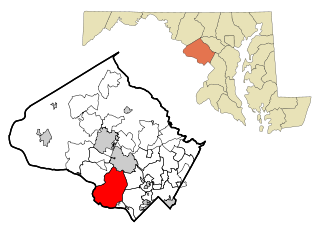
Potomac is an unincorporated community and census-designated place (CDP) in Montgomery County, Maryland. As of the 2020 census, it had a population of 47,018. It is named after the nearby Potomac River.

Bailey's Crossroads is a census-designated place (CDP) in Fairfax County, Virginia, United States. The population was 24,749 at the 2020 census. Bailey's Crossroads lies at the crossroads of State Route 7 and State Route 244.

Great Falls is a census-designated place (CDP) in Fairfax County, Virginia, United States. The population as of the 2010 census was 15,427, an increase of 80.5% from the 2000 census.

West Falls Church is a census-designated place (CDP) in Fairfax County, Virginia, United States. The population was 29,207 at the 2010 census. Before 2010, West Falls Church was officially named Jefferson. Outside of the Jefferson Village neighborhood, "Jefferson" generally is not used locally to refer to the area bounding Falls Church city to the south and southwest that comprises the CDP. Likewise, "West Falls Church" is rarely used to describe the area but is usually applied to areas west of Falls Church city or near West Falls Church Metro station. The bulk of it is made of subdivisions built in the 1940s and early 1950s, including Jefferson Village, Westlawn, Hillwood, Sleepy Hollow, Woodley, Raymondale and Broyhill Park.

McLean is an unincorporated community and census-designated place (CDP) in Fairfax County in Northern Virginia. McLean is home to many diplomats, military, members of Congress, and high-ranking government officials partially due to its proximity to Washington, D.C., the Pentagon and the Central Intelligence Agency. It is the location of Hickory Hill, the former home of Ethel Kennedy, the widow of Robert F. Kennedy. It is also the location of Salona, the former home of Light-Horse Harry Lee, the Revolutionary War hero.

Point of Rocks is an unincorporated community and census-designated place (CDP) in Frederick County, Maryland, United States. As of the 2010 census it had a population of 1,466. It is named for the striking rock formation on the adjacent Catoctin Mountain, which was formed by the Potomac River cutting through the ridge in a water gap, a typical formation in the Appalachian Mountains. The formation is not visible from the town and can only be seen from boats on the river, or from the southern bank of the river in Virginia.
The Potomac Heritage Trail, also known as the Potomac Heritage National Scenic Trail or the PHT, is a designated National Scenic Trail corridor spanning parts of the mid-Atlantic region of the United States that will connect various trails and historic sites in Virginia, Maryland, Pennsylvania, and the District of Columbia. The trail network includes 710 miles (1,140 km) of existing and planned sections, tracing the natural, historical, and cultural features of the Potomac River corridor, the upper Ohio River watershed in Pennsylvania and western Maryland, and a portion of the Rappahannock River watershed in Virginia. The trail is managed by the National Park Service and is one of three National Trails that are official NPS units.

The Patowmack Canal, sometimes called the Potomac Canal, is a series of five inoperative canals located in Maryland and Virginia, United States, that was designed to bypass rapids in the Potomac River upstream of the present Washington, D.C., area. The most well known of them is the Great Falls skirting canal, whose remains are managed by the National Park Service since it is within Great Falls Park, an integral part of the George Washington Memorial Parkway.

The Washington Aqueduct is an aqueduct that provides the public water supply system serving Washington, D.C., and parts of its suburbs, using water from the Potomac River. One of the first major aqueduct projects in the United States, the aqueduct was commissioned by the U.S. Congress in 1852, and construction began in 1853 under the supervision of Montgomery C. Meigs and the U.S. Army Corps of Engineers. Portions of the aqueduct went online on January 3, 1859, and the full pipeline began operating in 1864.

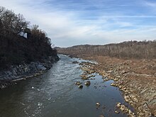
Great Falls is a series of rapids and waterfalls on the Potomac River, 14 miles (23 km) upstream from Washington, D.C., on the border of Montgomery County, Maryland and Fairfax County, Virginia. Great Falls Park, managed as part of George Washington Memorial Parkway, is on the southern banks in Virginia, and Chesapeake and Ohio Canal National Historical Park parkland is along the northern banks of the river in Maryland. Both are operated by the National Park Service. The Potomac and the falls themselves are legally entirely within Maryland, with the state and county boundaries following the south bank of the river.
The Washington Outer Beltway was a proposed freeway that would have extended further out than the Capital Beltway and encircled Washington, D.C. through the states of Maryland and Virginia. Most of the route was canceled in the 1980s. Parts of it have been built as the Fairfax County Parkway in Virginia, as well as Interstate 370 and the Intercounty Connector in Maryland.

The Northern Neck Proprietary – also called the Northern Neck land grant, Fairfax Proprietary, or Fairfax Grant – was a land grant first contrived by the exiled English King Charles II in 1649 and encompassing all the lands bounded by the Potomac and Rappahannock Rivers in colonial Virginia. This constituted up to 5,000,000 acres (20,000 km2) of Virginia's Northern Neck and a vast area northwest of it.
Matildaville is a ghost town located along the Patowmack Canal near present day Great Falls, Virginia, United States. It was named for the wife of Light Horse Harry Lee, on 40 acres of land owned at the time by Bryan Fairfax, 8th Lord Fairfax of Cameron, and served as headquarters for the Patowmack Company from 1785 until 1799. Now, all that remains of the town are a series of ruins on the grounds of Great Falls Park.

Minor's Hill is a geographic eminence located in the western tip of Arlington County, Virginia. Its summit rises to 459 feet above sea level which makes it the highest point in the county. The hill is named after a man named George Minor who lived there at the time of the American Revolutionary War.

Upton's Hill is a geographic eminence located in western Arlington County, Virginia. Its summit rises to 410 feet (120 m) above sea level.
This article is about the history of Falls Church, an independent city in Virginia, United States, in the Washington Metropolitan Area. The city population was 12,332 at the 2010 census. Taking its name from The Falls Church, an 18th-century Church of England parish, Falls Church gained township status within Fairfax County in 1875. In 1948, it was incorporated as the City of Falls Church, an independent city with county-level governance status. It is also referred to as Falls Church City.