Azurite Peak is an 8,400-foot (2,600-metre) double-summit mountain located at the common boundary point of Okanogan County, Skagit County, and Whatcom County in Washington state. It is part of the Okanogan Range which is a sub-range of the North Cascades Range. Azurite Peak is situated north of Azurite Pass on land administered by the Okanogan–Wenatchee National Forest. The nearest higher neighbor is Tower Mountain, 5.24 miles (8.43 km) to the south-southeast, and Mount Ballard lies 1.97 miles (3.17 km) to the north. Remnants of a small pocket glacier are found on the east aspect. The Pacific Crest Trail traverses the base of Azurite Peak.
Little Annapurna is an 8,440+ ft granite summit located in Chelan County of Washington state. The origin of the name came from the Sherpa Climbing Club of Ellensburg, and is inspired by the obvious resemblance to its Himalayan namesake when comparing the south faces of both. Little Annapurna is part of The Enchantments within the Alpine Lakes Wilderness, and is set on land managed by the Okanogan–Wenatchee National Forest. It belongs to the Stuart Range which is subset of the Cascade Range. Little Annapurna is situated southeast of Dragontail Peak, which is its nearest higher neighbor. Remnants of the receding Snow Creek Glacier can be found on its gentle north slope. Precipitation runoff drains into tributaries of the Wenatchee River.

Buck Mountain is an 8,528-foot (2,599-metre) mountain summit located in the Glacier Peak Wilderness of the North Cascades in Washington state. The mountain is situated in Chelan County, in the Wenatchee National Forest. Its nearest higher peak is Clark Mountain, 3.98 mi (6.41 km) to the southwest, and Brahma Peak is set 1.8 mi (2.9 km) to the south. Precipitation runoff from it drains into Buck Creek, Chiwawa River, and Napeequa River, each a tributary of the Wenatchee River. The mountain's name was applied by Albert Hale Sylvester (1871-1944), a pioneer surveyor, explorer, topographer, and forest supervisor in the Cascades.

Tupshin Peak is an 8,320+ ft mountain summit located in the Glacier Peak Wilderness of the North Cascades in Washington state. The mountain is situated in Chelan County, on land managed by Wenatchee National Forest. Its nearest higher peak is Devore Peak, 1.55 mi (2.49 km) to the south-southwest, and Bonanza Peak lies 6.71 mi (10.80 km) to the southwest. Precipitation runoff from the peak drains to nearby Lake Chelan via tributaries of the Stehekin River. The mountain's name comes from Chinook jargon and means "needle".

Napeequa Peak is an 8,073-foot (2,461-metre) pyramidal mountain summit located in the Glacier Peak Wilderness of the North Cascades in Washington state. The mountain is situated on the crest of the Cascade Range, on the shared border of Snohomish County and Chelan County, also straddling the boundary between the Mount Baker-Snoqualmie National Forest and the Wenatchee National Forest. Its nearest neighbor is Cirque Mountain, 0.3 mi (0.48 km) to the north, and the nearest higher peak is Buck Mountain, 2.56 mi (4.12 km) to the east-southeast. Precipitation runoff from the peak drains east to the headwaters of Napeequa River; or west into the Suiattle River. The mountain's name is taken from the river's name, which was applied by Albert Hale Sylvester (1871-1944), a pioneer surveyor, explorer, topographer, and forest supervisor in the Cascades.

Cathedral Peak is an 8,606-foot (2,623-metre) mountain summit located in Okanogan County in Washington state. It is part of the Okanogan Range which is a sub-range of the North Cascades. The mountain is situated in the Pasayten Wilderness, on land administered by the Okanogan–Wenatchee National Forest. The nearest higher peak is Grimface Mountain, 2.6 miles (4.2 km) to the north in Cathedral Provincial Park in Canada. The Pacific Northwest Trail traverses below the south slope of Cathedral Peak as it crosses Cathedral Pass. Less than a mile to the opposite side of the pass stands Amphitheater Mountain. Precipitation runoff from Cathedral Peak drains west into Cathedral Fork, or east into Cathedral Creek.

Castle Peak is a prominent 8,306-foot (2,532-metre) mountain summit located in the Hozameen Range of the North Cascades, on the shared border between Okanogan County and Whatcom County of Washington state. The mountain is situated 1 mile (1.6 km) south of the Canada–United States border, on the Cascade crest, in the Pasayten Wilderness, on land managed by the Okanogan–Wenatchee National Forest. The nearest higher peak is Jack Mountain, 14.8 miles (23.8 km) to the south-southwest. Castle Peak is the second highest summit of the Hozameen Range following Jack Mountain. Castle Peak is the fifth-most prominent mountain in the Pasaten Wilderness. Precipitation runoff from the mountain drains east into Castle Creek, a tributary of the Similkameen River, or west into tributaries of the Skagit River.
Mount Carru is an 8,595-foot (2,620-metre) mountain summit located in western Okanogan County in Washington state. It is the 7th highest peak of the Okanogan Range, which is a sub-range of the North Cascades. The mountain is situated in the Pasayten Wilderness, on land administered by the Okanogan–Wenatchee National Forest. The nearest higher peak is Mount Lago, 0.8 miles (1.3 km) to the east, and Osceola Peak stands 1 mile (1.6 km) west. The mountain has a steep north face, but the south slope is covered in scree which allows a nontechnical climbing ascent. Precipitation runoff from Mount Carru drains north into Lease Creek which is a tributary of the Pasayten River, or south into Eureka Creek, which is part of the Methow River drainage basin.

Copper Peak is an 8,964-foot (2,732-metre) mountain summit located in the Entiat Mountains, a sub-range of the North Cascades, in Chelan County of Washington state. Copper Peak is situated 80 miles northeast of Seattle in the Glacier Peak Wilderness, on land managed by the Wenatchee National Forest. Copper Peak ranks 22nd on Washington's highest 100 peaks, and 19th on the "Bulger List". The nearest higher peak is Mount Fernow, 0.88 miles (1.42 km) to the south. Precipitation runoff from the mountain and meltwater from the glacier on the southeast slope drains into nearby Lake Chelan via Railroad Creek. The first ascent of the peak was made in August 1937 by Franklin Bennet, Edgar Courtwright, and Toivo Hagman. The peak's name refers to an abandoned copper mine that once operated at the northeast base of the peak.

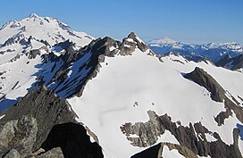
Brahma Peak is a remote 8,078-foot (2,462-metre) mountain summit located on Chiwawa Ridge in the North Cascades, in Chelan County of Washington state. The mountain is situated in the Glacier Peak Wilderness, on land managed by the Wenatchee National Forest. Its nearest higher neighbor is Buck Mountain, 1.8 mi (2.9 km) to the north. Brahma and Buck are set on Chiwawa Ridge, and other notable peaks on this ridge include Fortress Mountain, Cirque Mountain, Napeequa Peak, Mount Berge, Bandit Peak, and Chiwawa Mountain. Precipitation runoff from Brahma and meltwater from its glacier remnants drains into Chiwawa River and Napeequa River, both tributaries of the Wenatchee River. Topographic relief is significant since the southwest lavender-colored schist cliffs of this peak rise nearly 4,000 feet above the Napeequa River Valley in approximately one mile.

Emerald Peak is an 8,422-foot-elevation (2,567-meter) mountain summit located in the Chelan Mountains, in Chelan County of Washington state.

Saska Peak is an 8,404 ft (2,560 m) mountain summit located in the Chelan Mountains, in Chelan County of Washington state. The mountain is situated in Glacier Peak Wilderness of the North Cascades, on land managed by Wenatchee National Forest. Saska Peak ranks as the third-highest peak in the Chelan Mountains, and 74th-highest summit in Washington state. Its nearest higher neighbor is Emerald Peak, 0.66 mi (1.06 km) to the east-northeast, and Cardinal Peak is positioned 1.52 mi (2.45 km) to the east-southeast. These three highest peaks of the Chelan Mountains enclose the head of North Fork Entiat River valley. Precipitation runoff from the peak drains into the Entiat River drainage basin. The mountain's name honors Shil-how-Saskt, Tribal chief of the Entiat people, and was applied by Albert Hale Sylvester (1871-1944), a pioneer surveyor, topographer, and forest supervisor who named thousands of geographic features in the Cascades. In the Columbia-Moses language (Salishan), this name means "Standing in the middle of the sky."

Cirque Mountain is a 7,966-foot (2,428-metre) mountain summit located in the Glacier Peak Wilderness of the North Cascades in Washington state. The mountain is situated on the crest of the Cascade Range, on the shared border of Snohomish County and Chelan County, also straddling the boundary between the Mount Baker-Snoqualmie National Forest and the Wenatchee National Forest. Its nearest higher peak is Napeequa Peak, 0.3 mi (0.48 km) to the south. The peak is set on Chiwawa Ridge with Napeequa, and other notable peaks on this ridge include Fortress Mountain, Buck Mountain, Brahma Peak, Mount Berge, and Chiwawa Mountain. Topographic relief is significant since the western aspect of the mountain rises 4,000 feet above the Suiattle Valley in approximately 1.5 mi (2.4 km). This mountain has small, unnamed, hanging glaciers in cirques surrounding the summit. Precipitation runoff from the peak and meltwater from the glaciers drains east to the headwaters of Napeequa River; or west into the Suiattle River.

Pinnacle Mountain is an 8,400+ ft granitic multi-peak massif located in the Chelan Mountains, in Chelan County of Washington state. The mountain is situated in Glacier Peak Wilderness of the North Cascades, on land managed by Wenatchee National Forest. Fred Beckey's Cascade Alpine Guide has the elevation of the highest pinnacle as 8,402 feet. Pinnacle Mountain ranks as the fourth-highest peak in the Chelan Mountains, and 75th-highest summit in Washington state. Its nearest higher neighbor is Saska Peak, 1.9 mi (3.1 km) to the southeast, and Emerald Peak is positioned 2.25 mi (3.62 km) to the east-southeast. Precipitation runoff from the peak drains into the Entiat River and Chelan River drainage basins.

Tenpeak Mountain is an 8,200+ ft granitic mountain summit located in the Glacier Peak Wilderness of the North Cascades in Washington state. Fred Beckey's Cascade Alpine Guide has the elevation of the mountain as 8,281 feet. Tenpeak is situated on the crest of the Cascade Range, on the shared border of Snohomish County and Chelan County, also straddling the boundary between the Mount Baker-Snoqualmie National Forest and the Wenatchee National Forest. Its nearest higher neighbor is Luahna Peak, 2.5 mi (4.0 km) to the southeast. Topographic relief is significant since the northern aspect of the mountain rises 4,200 feet above the Suiattle Valley in approximately 1.5 mi (2.4 km). This mountain has small, unnamed, hanging glaciers in cirques surrounding the summit, and the terminus of the Honeycomb Glacier lies below the western base of the mountain. Precipitation runoff from the mountain and meltwater from the glaciers drains south into White River; or north into the Suiattle River. This mountain's descriptive name was suggested by The Mountaineers, and was officially adopted in 1918 by the U.S. Board on Geographic Names. The first ascent was made September 21, 1940, by Lloyd Anderson and Tom Campbell.
Martin Peak is an 8,511-foot (2,594-metre) mountain summit located in the North Cascades, in Chelan County of Washington state. Martin Peak is situated 80 miles northeast of Seattle, and 3 mi (4.8 km) northwest of Holden, in the Glacier Peak Wilderness, on land managed by the Wenatchee National Forest. Martin Peak ranks 56th on Washington's highest 100 peaks, and 54th on the "Bulger List". The nearest higher neighbor is Bonanza Peak, 2.35 miles (3.78 km) to the west, and Riddle Peak lies 3.7 miles (6.0 km) to the east-southeast. Precipitation runoff from the mountain and meltwater from the glacier in the east cirque drains into nearby Lake Chelan via Railroad Creek and Company Creek. Topographic relief is significant since the southern aspect of the mountain rises 4,900 feet above the Railroad Creek Valley in approximately 2 mi (3.2 km). The first ascent of the peak was made in July 1936 by Ida Zacher Darr.

Pasayten Peak is a 7,850-foot (2,390-metre) pyramidal-shaped mountain summit located in western Okanogan County in Washington state. It is part of the Okanogan Range which is a sub-range of the North Cascades. The mountain is situated in the Pasayten Wilderness, on land administered by the Okanogan–Wenatchee National Forest. The nearest higher neighbor is Wildcat Mountain, 3 miles (4.8 km) to the east-southeast, and Slate Peak is set 3.7 miles (6.0 km) to the south. Pasayten Peak is the high point of Gold Ridge, and precipitation runoff from this peak drains into the West and Middle Forks of Pasayten River.

Mount Berge is a 7,960-foot (2,430-metre) double-summit granitic mountain located in the Glacier Peak Wilderness of the North Cascades, in Chelan County of Washington state. The mountain is situated along the crest of the Cascade Range, on land managed by the Okanogan–Wenatchee National Forest. Its nearest higher neighbor is Napeequa Peak, 1.2 mi (1.9 km) to the west, and Buck Mountain is 1.7 mi (2.7 km) to the east-southeast. Berge is positioned on Chiwawa Ridge with Buck and Napeequa, and other notable peaks on this ridge include Fortress Mountain, Brahma Peak, Cirque Mountain, Helmet Butte, and Chiwawa Mountain. Precipitation runoff from Berge drains to the headwaters of Napeequa River; or east into tributaries of the Chiwawa River.

White Goat Mountain is a 7,800+ ft mountain summit located in the Glacier Peak Wilderness of the North Cascades in Washington state. The mountain is situated in Chelan County, on land managed by Wenatchee National Forest. Its nearest higher neighbor is Tupshin Peak, 0.7 mi (1.1 km) to the northeast, and Devore Peak is 1.02 mi (1.64 km) to the south. Precipitation runoff from the peak drains to nearby Lake Chelan via Company and Devore Creeks. The first ascent was made September 10, 1940, by Everett and Ida Zacher Darr, Joe Leuthold, and Eldon Metzger. A herd of mountain goats beneath the peak was their inspiration for so naming this geographical feature.

Le Conte Mountain is a 7,762-foot-elevation (2,366-meter) summit located on the shared boundary of Skagit County and Chelan County in Washington state. It is positioned on the crest of the North Cascades Range, and is set within the Glacier Peak Wilderness. Le Conte Mountain is situated on the shared border of Mount Baker-Snoqualmie National Forest and Okanogan-Wenatchee National Forest. Access to the peak is via the Ptarmigan Traverse. The nearest higher neighbor is Sentinel Peak, 1.87 miles (3.01 km) to the south-southeast, and Spider Mountain is 2.4 miles (3.9 km) to the northeast. The Le Conte Glacier and South Cascade Glacier lie to the south of the peak. Precipitation runoff on the east side the mountain drains into Flat Creek which is a tributary of the Stehekin River, while precipitation drains into headwaters of the South Fork Cascade River from the west side. Topographic relief is significant as the southwest aspect rises nearly 2,500 feet above South Cascade Lake in less than one-half mile, and the northeast aspect rises 3,200 feet above Flat Creek in one mile.