Metro (city)

Last updated
Metro
City of Metro
Kota Metro
Other transcription(s)
   Lampungese Lampung script - Metro City.png
Metro, Indonesia mayor's office.jpg
Metro's mayor's office
Lambang Kota Metro.jpeg
Nickname: 
Metro Raya
Motto(s): 
Bumi Sai Wawai (Lampungese)
The Beautiful Land
Peta Lokasi Kota Metro.svg
Location within Lampung
Location map Southern Sumatra.png
Red pog.svg
Metro
Location in Southern Sumatra, Sumatra and Indonesia
Indonesia Sumatra location map.svg
Red pog.svg
Metro
Metro (Sumatra)
Indonesia location map.svg
Red pog.svg
Metro
Metro (Indonesia)
Coordinates: 5°7′S105°18′E / 5.117°S 105.300°E / -5.117; 105.300
Country Flag of Indonesia.svg  Indonesia
Province Flag of Lampung.svg  Lampung
Settlement commenced 1939
Administrative city 14 August 1986
Autonomous city 9 June 1999
Government
  Mayor Wahdi
  Vice Mayor Qomaru Zaman
Area
  Total73.21 km2 (28.27 sq mi)
Elevation
30–60 m (98–197 ft)
Population
 (mid 2023 estimate)
  Total178,381
  Density2,400/km2 (6,300/sq mi)
  [1]
Time zone UTC+7 (Indonesia Western Time)
Area code (+62) 725
Vehicle registration BE
Website metrokota.go.id

Metro (Indonesian pronunciation: [Me'tro] ) is a city in the Indonesian province of Lampung. It is 52 km away from Bandar Lampung City (the provincial capital), and is the second largest city in Lampung province. This city is also the city that has the lowest congestion rate in Lampung Province. Metro City is included in the List of 10 cities in Indonesia with the 9th lowest cost of living in Indonesia and second on Sumatra Island based on the Indonesia Central Bureau of Statistics (BPS) Survey in 2017. Now, Metro City is making improvements and developing a city that is more advanced towards its vision and mission as an education city and family tourism in Lampung Province by improving the education, security, hygiene and improving public facilities, optimizing green open spaces, and beautifying every corner of the city with the construction of small parks. Metro City is also a blueprint target of the Ministry of Public Works and Public Housing of the Republic of Indonesia as a strategic area and a metropolitan development target after Bandar Lampung.

Contents

Etymology

The first version of the name Metro comes from the word "Meterm" in Dutch which means "center" which means in the middle between Central Lampung and East Lampung, even in the middle (center) of Lampung Province. The second version of the name Metro comes from the word "Mitro" (Javanese) which means friends, partners, associations, this was motivated by colonization coming from various regions outside Sumatra that entered Lampung. [2] [3] But the most relevant was Metro was from Dutch, it was strongly supported with its history and the establishment of a landmark in the form of a tower called the Meterm Tower in the Merdeka Park, Metro City Square.

History

Settlers arrive in Metro, c. 1939 Settlers in Metro, 1939.jpg
Settlers arrive in Metro, c. 1939

Prior to 1936, Trimurjo was part of Gunungsugih onder district; [4] it was isolated, without much influence from the indigenous Lampungese people. [5] However, beginning in 1936 the Dutch colonial government sent Javanese migrants to colonise the area, which served to relieve overpopulation on Java, and mitigate the influence of Indonesian independence activists. [6] The first group arrived on 4 April 1936. [7]

On 9 June 1937, the name of the area was changed from Trimurjo to Metro [2] and that same year it was established as a separate onder district, with Raden Mas Sudarto as the first assistant district chief. During this same period the Dutch colonial government built more roads, as well as a clinic, police office, and administrative offices. [8] By 1941 a mosque, post office, large market, and inn had been built, and electricity and telephone lines had been installed. [9]

Development soon outpaced the natural irrigation capabilities of the area. To ensure proper healthy crops, the Dutch hired Ir. Swam to design an irrigation system. His design called for a levee as well as a 30 metres (98 ft) wide and 10 metres (33 ft) deep irrigation canal from Way Sekampung River to Metro. Labour was provided by the migrants, who were conscripted and worked in shifts. Construction began in 1937 and was finished in 1941. [10]

After the Japanese invasion of Indonesia in 1942, all Dutch personnel were evacuated or captured. [11] The migration program was continued under the name imin kakari, [12] and seventy Javanese migrants were used as forced labour in the construction of the nearby Natar and Astra Ksetra airstrips as well as numerous bunkers and other strategic assets; those who resisted were shot. [11]

The remaining citizens were malnourished, with their harvests being taken by the Japanese occupying forces. Diseases spread rampantly throughout the populace, carried by ticks. Deaths were common, as were women, including wives of the forced labourers, being taken as comfort women. [12]

During the Indonesian war of independence, the Dutch attempted to retake Metro. When they first arrived, they were unable to enter as the bridge to the city in Tempuran had been destroyed by a 26-man troop of the Indonesian army, under the command of Second Lieutenant Bursyah; the Dutch convoy was forced to retreat. However, the following day the Dutch returned in greater numbers and attacked from Tegineneng, eventually entering the city and killing three Indonesian soldiers. [13]

Upon entering the city, the Dutch forces were besieged by sabotage by 41 soldiers under the command of Second Lieutenant Raden Sudarto. After chasing Sudarto's forces throughout the area, the Dutch continued to Palembang. Despite an extended guerrilla campaign by the Indonesian military, the Dutch eventually retook Metro in 1949, surrendering it that same year. [14]

After the war, Metro continued to develop. In 1956, its government was stylized as a negeri based on Governor's Decree Number 153/D/1956. This led to adat lands being owned by the local government. [15]

In 1976 Metro became the capital of the newly formed Central Lampung Regency, which at the time included parts of present-day East Lampung Regency. [16]

This fountain is one of the additions to the town square and has now been replaced by the Magnificent Meterm Tower Fountain in Metro town square.jpg
This fountain is one of the additions to the town square and has now been replaced by the Magnificent Meterm Tower

Beginning in 1985, the local government began working to stimulate the economy. Retail chains began entering the city, a movie theatre and stadium was built, the town square was redesigned as a park, and Cendrawasih market was renovated. [17]

On 14 August 1986, Metro was designated an administrative city, in accordance with Government Decree Number 34 of 1986, with the formal ceremony taking place on 6 September 1987. [18]

Metro was established as an autonomous city (kota) with the passing of Law Number 12 of 1999 on 27 April 1999, [19] with Gunungsugih becoming the capital of Central Lampung. [20] The first mayor after Metro's establishment as an autonomous city was Mozes Herman, with Lukman Hakim as vice-mayor. [21]

Geography and climate

Metro is spread over an area of 73.21 square kilometres (28.27 sq mi), [22] with the built up area consisting of 24.57% of the city, or 16.88 square kilometres (6.52 sq mi). [23] As of 2010, it had a population of 145,346, with a density of 2,116.2 people per km2 (5,480.9/sq mi); [24] the 2020 census resulted in a population of 168,676, giving a density of 2,453.8 people per km2 (6,355.5/sq mi). [25] The official estimate of population as at mid 2023 was 178,381 (comprising 89,678 males and 88,703 females). [1] The city is built around the Dutch land use planning system. Its economic and political hub is in the center, in the area around the city park. All five provincial and national roads that transect Metro meet in this area. [26] Northern Metro is a residential area, while western Metro is used for commercial space, southern Metro for agriculture, and parts of southern and eastern Metro for educational and other public facilities. [27]

The land in Metro is relatively flat, with an elevation of between 30 and 60 metres (98–197 ft). [28] When it was first settled, the area was heavily forested; there are still pockets of forest within the city limits. [7]

The climate in Metro is humid and tropical. The average air temperature is between 26 and 28 °C (79 and 82 °F), with an average humidity of 80 to 88% and an average yearly precipitation of 2,264 to 2,868 millimetres (89.1 to 112.9 in). The dry season usually lasts from September until May. [28]

Administrative divisions

District divisions of Metro PetaCamatMetro.jpg
District divisions of Metro

When Metro was originally made an autonomous city, it had two kecamatan, or administrative districts, Metro Raya and Metro Bantul. [19] However, it now is divided into five districts ( kecamatan ), tabulated below with their populations at the 2010 census [24] and at the 2020 census, [25] together with the official estimates as at mid 2023. [1] The table also includes the number of administrative villages in each district (all classed as urban kelurahan).

Kode
Wilayah
Name of
District
(kecamatan)
Area
in
km2
Pop'n
2010
census
Pop'n
2020
census
Pop'n
mid 2023
estimate
No.
of
villages
Post
codes
18.72.05Metro Selatan
(South Metro)
15.0314,14417,38518,353434119, 34121,
34122, 34123
18.72.03Metro Barat
(West Metro)
11.5425,24628,42429,014434114 & 34125
18.72.04Metro Timur
(East Metro)
12.8934,96638,15440,968534111, 34112,
34124
18.72.01Metro Pusat
(Central Metro)
11.6046,17052,63555,740534111 & 34113
18.72.02Metro Utara
(North Metro)
22.1524,94532,07834,306434117 - 34119
Total city73.21145,346168,676178,38122

The five districts are subdivided into 22 administrative urban villages (kelurahan), each listed with its population at the 2010 census and its postal code.

KecamatanKelurahanPop'n
census
2010 [24]
Post
code
Metro SelatanSumbersari2,88134122
"Rejomulyo4,30234123
"Margodadi2,57434119
"Margorejo4,38734121
Metro BaratMulyojati8,03534125
"Mulyosari2,79834125
"Ganjar Agung6,13634114
"Ganjar Asdi8,27734125
Metro TimurTejosari2,73834124
"Tejo Agung5,34634112
"Iringmulyo12,42534112
"Yosorejo6,67234112
"Yosodadi7,78534111
Metro PusatMetro13,42534111
"Imopuro6,61634111
"Hadimulyo Barat11,69634113
"Hadimulyo Timur7,33334113
"Yosomulyo7,10035111
Metro UtaraBanjarsari9,30934117
"Purwosari4,86034118
"Purwoasri3,35634117
"Karangrejo7,42034119

Economy

In 2002, Metro had a budget of Rp 336 billion (US$37.3 million). [29] The largest contributor to Metro's economy is the service sector, contributing 22.94% of the city's income in 2002. [30]

The second largest contributor to Metro's economy is retail, contributing 19.77% of the city's 2002 income. [30] In 2004, there were 13 markets, 1,881 stores, and 682 food kiosks, as well as numerous street vendors. [31]

The third largest economic sector is agriculture, contributing 17.31% of the 2002 income. [30] Within the city boundaries there are 3,342 hectares of rice fields, capable of producing up to 16,598 tons of rice per growing season. [32]

Numerous banks have branches in Metro, including Bank Mandiri, Bank Lampung, Bank Danamon, Bank Eka, Bank Central Asia, Bank Rakyat Indonesia, Bank Maybank Indonesia, and as well as Bank Negara Indonesia. [31]

Healthcare

Metro is served by three hospitals: Ahmad Yani General Hospital, Mardi Waluyo Hospital, and Metro Islamic Hospital. As of 2003, the total number of health care practitioners in Metro is 382, including 13 specialists, 30 general practitioners, 36 midwives, 121 nurses, and 8 dentists. There are also 19 pharmacies and 8 drug stores. [33]

Education

Metro is served by numerous public and private schools. There are 63 elementary schools, 25 junior high schools (eight public and seventeen private), two junior high schools for special-needs children, 16 senior high schools, and 15 vocational schools. [34]

Public universities

Private colleges and academies

Related Research Articles

<span class="mw-page-title-main">Special Region of Yogyakarta</span> Special autonomous region of Indonesia

The Special Region of Yogyakarta is a province-level special region of Indonesia in southern Java. It is a semi-enclave that is surrounded by on the landward side by Central Java Province to the west, north, and east, but has a long coastline on the Indian Ocean to the south.

<span class="mw-page-title-main">Palembang</span> City and capital of South Sumatra, Indonesia

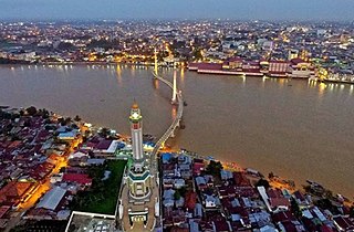
Palembang is the capital city of the Indonesian province of South Sumatra. The city proper covers 352.51 square kilometres on both banks of the Musi River in the eastern lowlands of southern Sumatra. It had a population of 1,668,848 at the 2020 Census; the official estimate as at mid 2022 was 1,729,546. Palembang is the second most populous city in Sumatra, after Medan, and the twelfth most populous city in Indonesia.

<span class="mw-page-title-main">Lampung</span> Province of Indonesia

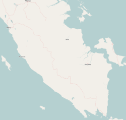
Lampung, officially the Province of Lampung, is a province of Indonesia. It is located on the southern tip of the island of Sumatra. It has a short border with the province of Bengkulu to the northwest, and a longer border with the province of South Sumatra to the north, as well a maritime border with the province of Banten and Jakarta to the east. It is the original home of the Lampung people, who speak their own language, and possess their own written script. Its capital is Bandar Lampung.

<span class="mw-page-title-main">Pekanbaru</span> City and capital of Riau, Indonesia

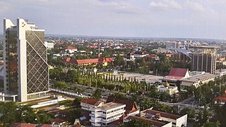
Pekanbaru is the capital city of the Indonesian province of Riau, and a major economic centre on the eastern side of Sumatra Island with its name derived from the Malay words for 'new market' . It has an area of 632.26 km2 (244.12 sq mi), with a population of 897,767 at the 2010 Census, and 983,356 at the 2020 Census; the official estimate as at mid 2022 was 1,007,540. It is located on the banks of the Siak River, which flows into the Strait of Malacca, Pekanbaru has direct access to the busy strait and has long been known as a trading port.

<span class="mw-page-title-main">Semarang</span> Capital of Central Java, Indonesia

Semarang is the capital and largest city of Central Java province in Indonesia. It was a major port during the Dutch colonial era, and is still an important regional center and port today. The city has been named as the cleanest tourist destination in Southeast Asia by the ASEAN Clean Tourist City Standard (ACTCS) for 2020–2022.

<span class="mw-page-title-main">Sibolga</span> City in North Sumatra, Indonesia

Sibolga is a city and a port located in the natural harbour of Sibolga Bay on the west coast of North Sumatra province, in Indonesia.

<span class="mw-page-title-main">Kupang</span> City and capital of East Nusa Tenggara, Indonesia

Kupang, formerly known as Koepang or Coupang, is the capital of the Indonesian province of East Nusa Tenggara. At the 2020 Census, it had a population of 442,758; the official estimate as of mid-2023 was 466,632. It is the largest city and port on the island of Timor, and is a part of the Timor Leste–Indonesia–Australia Growth Triangle free trade zone. Geographically, Kupang is the southernmost city in Indonesia.

<span class="mw-page-title-main">Bandar Lampung</span> City and capital of Lampung, Indonesia

Bandar Lampung is the capital and largest city of the Indonesian province of Lampung. Located on the southern tip of Sumatra, Bandar Lampung was originally called Tanjungkarang–Telukbetung, since it was a unification of two major settlements in Lampung, before being renamed in 1983.

<span class="mw-page-title-main">Probolinggo</span> City in East Java, Indonesia

Probolinggo is a city on the north coast of East Java province, Indonesia. It covers an area of 56.676 sq. km, and had a population of 217,062 at the 2010 census and 239,649 at the 2020 census; the official estimate as at mid 2023 was 246,980. It is surrounded on the landward side by Probolinggo Regency of which it was formerly the capital, but it is now not part of the regency.

<span class="mw-page-title-main">West Jakarta</span> Administrative city in Jakarta, Indonesia

West Jakarta is one of the five administrative cities of the Special Capital Region of Jakarta, Indonesia. West Jakarta is not self-governed and does not have a city council, hence it is not classified as a proper municipality. It had a population of 2,281,945 at the 2010 Census and 2,434,511 at the 2020 Census; the official estimate as at mid 2022 was 2,589,589 according to the BPS webpage for Jakarta Barat; however, the figure for Jakarta Barat according to the BPS DKI Jakarta webpage was 2,448,975. The administrative center of West Jakarta is at Puri Kembangan.

<span class="mw-page-title-main">Madiun</span> City in East Java, Indonesia

Madiun is a landlocked city in the western part of East Java, Indonesia, known for its agricultural center. The city has been administratively separate from the surrounding Madiun Regency since the formation of the two bodies in 1950, but the city remained the seat of the regency administration until 2010. Madiun is commonly known as "Kota Gadis", which is an acronym for "Trading, Education and Industrial City" in Indonesian and sometimes known as Milaan van Java in Dutch language.

<span class="mw-page-title-main">Mojokerto</span> City in East Java, Indonesia

Mojokerto is a city in East Java Province of Indonesia. It is located 40 km southwest of Surabaya, the provincial capital, and constitutes one of the component units of the Surabaya metropolitan area which comprises Gresik Regency, Bangkalan Regency, Mojokerto Regency, Mojokerto City, Surabaya City, Sidoarjo Regency, and Lamongan Regency. The city covers an area of 20.21 km2, and had a population of 120,196 at the 2010 census and 132,434 at the 2020 Census; the official estimate as of mid-2023 was 141,785.

<span class="mw-page-title-main">Yogyakarta</span> Capital of the Special Region of Yogyakarta, Indonesia

Yogyakarta is the capital city of the Special Region of Yogyakarta in Indonesia, in the south-central part of the island of Java. As the only Indonesian royal city still ruled by a monarchy, Yogyakarta is regarded as an important centre for classical Javanese fine arts and culture such as ballet, batik textiles, drama, literature, music, poetry, silversmithing, visual arts, and wayang puppetry. Renowned as a centre of Indonesian education, Yogyakarta is home to a large student population and dozens of schools and universities, including Gadjah Mada University, the country's largest institute of higher education and one of its most prestigious.

<span class="mw-page-title-main">Pariaman</span> City in West Sumatra, Indonesia

Pariaman, is a coastal city in West Sumatra, Indonesia. Pariaman covers an area of 73.36 km2 (28 sq mi), with a 12 km (7 mi) coastline. It had a population of 79,043 at the 2010 Census and 94,224 at the 2020 census; the official estimate as at mid 2022 was 96,719 - comprising 48,864 males and 47,855 females. "Pariaman" means "safe area".

<span class="mw-page-title-main">Klaten Regency</span> Regency in Indonesia

Klaten Regency is a regency in Central Java province in Indonesia. It covers an area of 701.52 km2 and had a population of 1,130,047 at the 2010 Census and 1,260,506 at the 2020 Census; the official estimate as at mid 2023 was 1,284,386. Its administrative centre is in the town of the same name; the town extends over 35.85 km2 to encompass three of the regency's districts, with a combined total of 135,681 inhabitants in mid 2023; a fourth district (Kalikotes) is part of its urban area.

<span class="mw-page-title-main">Jambi (city)</span> City and capital of Jambi, Indonesia

Jambi is the capital and largest city of the Indonesian province of Jambi. Located on the island of Sumatra, the city is a busy port on the Batang Hari River and an oil- and rubber-producing centre. The city is located 26 km (16 mi) from the ruins of Muaro Jambi Temple Compounds, an important city in the ancient Srivijaya kingdom.

<span class="mw-page-title-main">Bengkulu (city)</span> City and capital of Bengkulu, Indonesia

Bengkulu, formerly Bencoolen is the capital of the Indonesian province of Bengkulu. The city is the second largest city on the west coast of Sumatra Island after Padang. Previously this area was under the influence of the kingdom of Inderapura and the Sultanate of Banten. The city also became the exile of Sukarno from 1939 to 1942. It covers an area of 151.70 km2 and had a population of 308,544 at the 2010 Census and 373,591 at the 2020 Census; the official estimate as of mid-2022 was 384,841. The city is also the only city in Bengkulu Province.

<span class="mw-page-title-main">Kediri (city)</span> City in East Java, Indonesia

Kediri is a city, located near the Brantas River in the province of East Java on the island of Java in Indonesia. It covers an area of 67.23 km2 and had a population of 268,950 at the 2010 Census and 286,796 at the 2020 Census; the official estimate as at mid 2023 was 298,830. It is one of two 'Daerah Tingkat II' that have the name 'Kediri'. The city is administratively separated from the Regency, of which it was formerly the capital.

<span class="mw-page-title-main">Sarmi Regency</span> Regency in Papua, Indonesia

Sarmi Regency is one of the regencies (kabupaten) in Papua Province of Indonesia. It was formed from the western districts which had until then been part of Jayapura Regency with effect from 12 November 2002. It covers an area of 18,034.0 km2, and had a population of 32,971 at the 2010 Census and 41,515 at the 2020 Census; the official estimate as at mid 2022 was 42,233. The regency's administrative centre is at the town of Sarmi.

<span class="mw-page-title-main">West Lampung Regency</span> Regency in Lampung, Indonesia

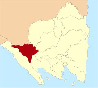
West Lampung Regency is a landlocked regency of Lampung Province, in the south of Sumatra, Indonesia. It was originally created on 16 August 1991 by splitting off the western districts of the existing North Lampung Regency; and until 2012 it had an area of 4,950.4 km2 of which forests occupied some 57% of the total area. It had a population of 418,560 people at the 2010 census. However, on 25 October 2012 the southwestern part of this area was separated from West Lampung Regency to form the new Pesisir Barat Regency.

References

  1. 1 2 3 Badan Pusat Statistik, Jakarta, 28 February 2024, Kota Metro Dalam Angka 2024 (Katalog-BPS 1102001.1872)
  2. 1 2 Sudarmono & Edi Ribut Harwanto 2004 , p. 28
  3. Prahana 1997 , p. 20
  4. Sudarmono & Edi Ribut Harwanto 2004 , p. 18
  5. Sudarmono & Edi Ribut Harwanto 2004 , p. 2
  6. Sudarmono & Edi Ribut Harwanto 2004 , p. 25
  7. 1 2 Sudarmono & Edi Ribut Harwanto 2004 , p. 20
  8. Sudarmono & Edi Ribut Harwanto 2004 , pp. 29–30
  9. Sudarmono & Edi Ribut Harwanto 2004 , p. 30
  10. Sudarmono & Edi Ribut Harwanto 2004 , pp. 31–39
  11. 1 2 Sudarmono & Edi Ribut Harwanto 2004 , pp. 48–50
  12. 1 2 Sudarmono & Edi Ribut Harwanto 2004 , p. 54
  13. Sudarmono & Edi Ribut Harwanto 2004 , pp. 58–59
  14. Sudarmono & Edi Ribut Harwanto 2004 , pp. 62–67
  15. Sudarmono & Edi Ribut Harwanto 2004 , p. 71
  16. Sudarmono & Edi Ribut Harwanto 2004 , p. 72
  17. Sudarmono & Edi Ribut Harwanto 2004 , pp. 76–79
  18. Sudarmono & Edi Ribut Harwanto 2004 , p. 82
  19. 1 2 Sudarmono & Edi Ribut Harwanto 2004 , p. 93
  20. Sudarmono & Edi Ribut Harwanto 2004 , p. 4
  21. Sudarmono & Edi Ribut Harwanto 2004 , p. 84
  22. Sudarmono & Edi Ribut Harwanto 2004 , p. 137
  23. Sudarmono & Edi Ribut Harwanto 2004 , p. 120
  24. 1 2 3 Biro Pusat Statistik, Jakarta, 2011.
  25. 1 2 Badan Pusat Statistik, Jakarta, 2021.
  26. Sudarmono & Edi Ribut Harwanto 2004 , p. 142
  27. Sudarmono & Edi Ribut Harwanto 2004 , pp. 144–145
  28. 1 2 "Metro selayang pandang". Metro City Government. 2010. Archived from the original on 4 October 2011. Retrieved 6 July 2011.
  29. Sudarmono & Edi Ribut Harwanto 2004 , p. 149
  30. 1 2 3 Sudarmono & Edi Ribut Harwanto 2004 , p. 134
  31. 1 2 Sudarmono & Edi Ribut Harwanto 2004 , p. 153
  32. Sudarmono & Edi Ribut Harwanto 2004 , p. 124
  33. Sudarmono & Edi Ribut Harwanto 2004 , pp. 137–139
  34. Sudarmono & Edi Ribut Harwanto 2004 , pp. 129–130

Bibliography