Lampung, officially the Province of Lampung, is a province of Indonesia. It is located on the southern tip of the island of Sumatra. It has a short border with the province of Bengkulu to the northwest, and a longer border with the province of South Sumatra to the north, as well a maritime border with the province of Banten and Jakarta to the east. It is the original home of the Lampung people, who speak their own language, and possess their own written script. Its capital is Bandar Lampung.

Bulungan Regency is a regency of North Kalimantan Province in Indonesia. It covers an area of 13,181.92 km2 and had a population of 112,663 at the 2010 Census and 151,844 at the 2020 Census; the official estimate as at mid 2023 was 165,775. The administrative centre is at Tanjung Selor.

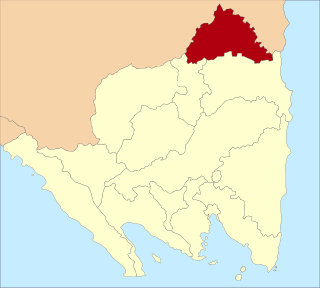
Nunukan Regency is a regency of North Kalimantan Province in Indonesia. It was created on 4 October 1999 from the northern districts of Bulungan Regency. Nunukan Regency shares international borders with the Malaysian states of Sabah to the north and Sarawak to the west, and inter-regency borders with Tana Tidung Regency and Malinau Regency to the south, as well as the coastal city of Tarakan in the east. The regency covers an area of 14,247.50 km2 and it had a population of 140,841 at the 2010 census and 199,090 at the 2020 census; the official estimate as at mid 2023 was 217,923.
In Indonesia, village or subdistrict is the fourth-level subdivision and the smallest administrative division of Indonesia below a district, regency/city, and province. Similar administrative divisions outside of Indonesia include barangays in the Philippines, Muban in Thailand, civil townships and incorporated municipalities in the United States and Canada, communes in France and Vietnam, dehestan in Iran, hromada in Ukraine, Gemeinden in Germany, comuni in Italy, or municipios in Spain. The UK equivalent are civil parishes in England and communities in Wales. There are a number of names and types for villages in Indonesia, with desa being the most frequently used for regencies, and kelurahan for cities or for those communities within regencies which have town characteristics. According to the 2019 report by the Ministry of Home Affairs, there are 8,488 urban villages and 74,953 rural villages in Indonesia. North Aceh Regency contained the highest number of rural villages (852) amongst all of the regencies of Indonesia, followed by Pidie Regency with 730 rural villages and Bireuen Regency with 609 rural villages. Prabumulih, with only 12 rural villages, contained the fewest. Counted together, the sixteen regencies of Indonesia containing the most rural villages—namely, North Aceh (852), Pidie (730), Bireuen (609), Aceh Besar (604), Tolikara (541), East Aceh (513), Yahukimo (510), Purworejo (469), Lamongan (462), South Nias (459), Kebumen (449), Garut (421), Bojonegoro (419), Bogor (416), Cirebon (412), and Pati (401)—contain one-third of all the rural villages in Indonesia. Five of these are located in Aceh, two in Highland Papua, three in Central Java, two in East Java, three in West Java, and one in North Sumatra. An average number of rural villages in the regencies and 15 cities of Indonesia is 172 villages. A village is the lowest administrative division in Indonesia, and it is the lowest of the four levels. A village is usually divided into a number of hamlets, and there are 252,315 hamlets in Indonesia.

Rejang Lebong is a regency of Bengkulu Province, Indonesia, on the island of Sumatra. This regency originally included a much larger part of the inland district of the province, but on 25 February 2003 it was divided in three, with districts in the northwest being split off to form a separate Lebong Regency, and districts in the south being similarly split off to form a new Kepahiang Regency. The residual Rejang Lebong Regency now covers 1,550.28 km² and had a population of 246,787 at the 2010 Census and 276,645 at the 2020 Census; the official estimate as at mid 2022 was 281,281. The administrative centre of the Rejang Lebong Regency is the town of Curup. The Rejangese people are the most numerous ethnic group in Bengkulu Province, and inhabit the western half of the Regency, while the Lembak people inhabit the eastern half.

Bintan Regency is an administrative area in the Riau Islands Province of Indonesia. Bintan Regency includes all of Bintan Island and also includes many outlying islands including the Tambelan Archipelago and Badas Islands situated between Bintan and West Kalimantan.
North Labuhanbatu Regency is a regency of North Sumatra, Indonesia, created on 21 July 2008 by being carved out of the north-western districts of the existing Labuhanbatu Regency, which until 2008 covered an area of 9,703 square kilometres and had a population of 840,382 according to the 2000 census. 60.99% of the regency is forested. The new North Labuhanbatu Regency covers 3,545.8 square kilometres and had a population of 331,660 at the 2010 Census, rising to 381,994 at the 2020 Census; the official estimate as at mid 2023 was 401,863 . The Kualuh River is located in this regency. The administrative centre of the regency is at the town of Aek Kanopan.
Ogan Komering Ilir Regency is a regency of South Sumatra Province, Indonesia. It takes its name from the Ogan River and the Komering River, which are the two main rivers that drain the area. The name Ilir means downstream. The administrative centre is the town of Kayu Agung. The regency borders Banyuasin Regency to the northwest, Bangka Strait, and the Java Sea to the east, Lampung Province to the south, and Palembang city, Ogan Ilir Regency, and East Ogan Komering Ulu Regency to the west.
East Lampung Regency is a regency (kabupaten) of Lampung Province, Sumatra, Indonesia. It has an area of 5,325.03 km2 and a population of 951,639 people at the 2010 census and 1,110,340 at the 2020 census. The official estimate as at mid 2023 was 1,114,016 - comprising 566,648 males and 547,368 females. The regency seat is at the town of Sukadana.
Mesuji Regency is a regency (kabupaten) of Lampung Province, on Sumatra island, Indonesia. It was created on 29 October 2008 from what were previously the most northern districts of Tulang Bawang Regency. It has an area of 2,200.51 km2 and a population of 187,286 people at the 2010 census and 227,518 at the 2020 census; the official estimate as at mid 2022 was 232,685. The regency seat is the town of Mesuji.

Tanggamus Regency is a regency (kabupaten) of Lampung Province, Sumatra, Indonesia. It has an area of 4,654.96 km² and had a population of 534,595 at the 2010 Census and 640,275 at the 2020 Census; the official estimate as at mid 2022 was 652,898. The regency seat is the town of Kota Agung Pusat. The regency was created on 21 March 1997, but districts in its eastern part split away on 29 October 2008 to form the new Pringsewu Regency. It lies in the southwest of the province, and surrounds Semangka Bay on its west, north and east coasts.

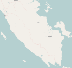
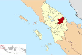
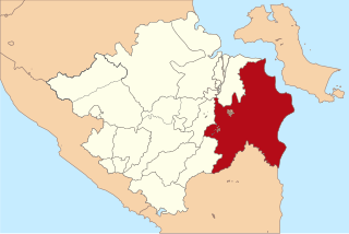
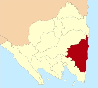
Tulang Bawang Regency is a regency (kabupaten) of Lampung Province, Sumatra, Indonesia. The regency was created on 3 January 1997 from the eastern half of North Lampung Regency; when created, it originally covered a much wider area, but on 29 October 2008 the 7 northern districts were separated off to form a new Mesuji Regency, and the 8 western districts were also separated off to form a new West Tulang Bawang Regency. It now has an area of 3,466.32 square kilometres (1,338.35 sq mi) and had a population of 397,906 at the 2010 Census and 430,021 at the 2020 Census; the official estimate as at mid 2022 was 431,208. The regency seat is the town of Menggala, located about 120 kilometres (75 mi) from the provincial capital of Bandar Lampung. The regency takes its name from the Tulang Bawang River which flows through the province.

West Tulang Bawang Regency is a regency (kabupaten) of Lampung Province, Sumatra, Indonesia. It was created on 29 October 2008 from what were formerly the western districts of Tulang Bawang Regency. It has an area of 1,201.15 km2 and had a population of 250,707 people at the 2010 Census and 286,162 at the 2020 Census; the official estimate as at mid 2022 was 289,620. The regency seat is the town of Panaragan Jaya.

Minahasa Regency is a regency in North Sulawesi, Indonesia. Its capital is Tondano. It covers an area of 1,141.64 km2 and had a population of 310,384 at the 2010 Census; this rose to 347,290 at the 2020 Census, and the official estimate as at mid 2023 was 351,920.
Curup is a town and district of Rejang Lebong Regency, part of Bengkulu Province of Indonesia. It is also the administrative capital of the regency. Curup is the second-largest town in the province of Bengkulu. Curup District has an area of 6.21 km², consisting of nine Administrative villages, with 26,971 residents at the 2020 Census, rising to 27,017 in the official estimates as at mid 2021. However, the urban area of which Curup District is the centre - including also South Curup, North Curup, Central Curup, and East Curup Districts - covered 174.05 km² and had a mid 2021 population of 130,888.
Banjar Agung is a district (kecamatan) located in the Tulang Bawang Regency of Lampung Province in Sumatra, Indonesia.
Banjar Baru is a district (kecamatan) located in the Tulang Bawang Regency of Lampung Province in Sumatra, Indonesia.
East Rawajitu is a district located in the Tulang Bawang Regency of Lampung Province in Sumatra, Indonesia.