Mount Geikie (Wyoming)

Last updated
Mount Geikie
Mount Geikie, Wind River Range.jpg
Southeast aspect, left of center
Highest point
Elevation 12,378 ft (3,773 m) [1]
Prominence 1,078 ft (329 m) [2]
Parent peak Raid Peak (12,537 ft) [2]
Isolation 2.08 mi (3.35 km) [2]
Coordinates 42°49′44″N109°19′50″W / 42.8287811°N 109.3306816°W / 42.8287811; -109.3306816 [3]
Naming
Etymology Archibald Geikie
Geography
USA Wyoming location map.svg
Red triangle with thick white border.svg
Mount Geikie
Location in Wyoming
Usa edcp relief location map.png
Red triangle with thick white border.svg
Mount Geikie
Mount Geikie (the United States)
CountryUnited States
State Wyoming
County Sublette
Protected area Bridger Wilderness
Parent range Rocky Mountains
Wind River Range [1]
Topo map USGS Mount Bonneville
Geology
Type of rock granitic
Climbing
First ascent 1890 William O. Owen [4]
Easiest route class 2 hiking [2]

Mount Geikie is a 12,378-foot-elevation (3,773-meter) mountain summit in Sublette County, Wyoming, United States. [3]

Contents

Description

Mount Geikie is located in the remote Wind River Range, which is a subrange of the Rocky Mountains. It is set three miles west of the Continental Divide within the Bridger Wilderness, on land managed by Bridger-Teton National Forest. The nearest town is Pinedale, 26.5 miles (42.6 km) to the west. Geikie ranks as the 113th-highest peak in Wyoming, [2] and topographic relief is significant as the summit rises 2,140 feet (650 meters) above the East Fork River in one-half mile (0.8 km). Precipitation runoff from the mountain drains into East Fork and other tributaries of the Green River.

Climate

According to the Köppen climate classification system, Mount Geikie is located in an alpine subarctic climate zone with long, cold, snowy winters, and cool to warm summers. [5] Due to its altitude, it receives precipitation all year, as snow in winter and as thunderstorms in summer.

Climbing history

The first ascent of the summit was made in 1890 by surveyor William O. Owen. The East Rib was first climbed in 1972 by Steve Bassnett and Nigel Peacock, whereas the south slope was first climbed in 1973 by John Coover, Ward Wickwire, and Eberhard Zeh. [4]

Etymology

Archibald Geikie Portrait of Archibald Geikie.jpg
Archibald Geikie

The mountain's toponym has been officially adopted by the United States Board on Geographic Names. [3] The mountain was named in 1900 by the USGS for Sir Archibald Geikie (1835–1924), director general of the Geological Survey of the United Kingdom. [6] [7]

Hazards

Encountering bears is a concern in the Wind River Range. [8] There are other concerns as well, including bugs, wildfires, adverse snow conditions and nighttime cold temperatures. [9]

Importantly, there have been notable incidents, including accidental deaths, due to falls from steep cliffs (a misstep could be fatal in this class 4/5 terrain) and due to falling rocks, over the years, including 1993, [10] 2007 (involving an experienced NOLS leader), [11] 2015 [12] and 2018. [13] Other incidents include a seriously injured backpacker being airlifted near Squaretop Mountain [14] in 2005, [15] and a fatal hiker incident (from an apparent accidental fall) in 2006 that involved state search and rescue. [16] The U.S. Forest Service does not offer updated aggregated records on the official number of fatalities in the Wind River Range.

See also

Related Research Articles

<span class="mw-page-title-main">Fremont Peak (Wyoming)</span> Mountain in the state of Wyoming

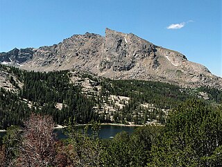
Fremont Peak is the third highest peak in the state of Wyoming, surpassed only by Gannett Peak and Grand Teton, and straddles the boundary between Fremont and Sublette counties in the Wind River Range. It is named for American explorer John C. Fremont who climbed the peak with Charles Preuss and Johnny Janisse from August 13 to August 15, 1842. Kit Carson had been with the climbing party on its first attempt at the peak, but had gone back for supplies the day Fremont and his men reached the summit. Carson is thought by some to have been the first to climb neighboring Jackson Peak. At that time, Fremont Peak was mistakenly thought to be the highest mountain in the Rocky Mountains, although there are actually over 100 higher peaks in the Rocky Mountain range.

<span class="mw-page-title-main">Mount Warren</span> Mountain in the state of Wyoming

Mount Warren is located in the Wind River Range in the U.S. state of Wyoming. The peak is the third peak in the range and the fourth tallest in Wyoming. The summit is located in the Fitzpatrick Wilderness of Shoshone National Forest and rises above several glaciers, the best known being Dinwoody Glacier which is immediately north of the summit tower. The mountain abuts, but is not within, either Bridger National Forest or Sublette County, Wyoming.

Doublet Peak is the sixth-highest peak in the U.S. state of Wyoming and the fifth-highest in the Wind River Range. The summit is immediately south of Dinwoody Glacier and just west of Mount Warren.

<span class="mw-page-title-main">Mount Sacagawea</span> Mountain in Wyoming, United States

Mount Sacagawea is the eighth-highest peak in the U.S. state of Wyoming and the seventh-highest in the Wind River Range. It was named after Sacagawea, the young Lemhi Shoshone woman who accompanied the Lewis and Clark Expedition as an interpreter and guide. The Upper Fremont Glacier is located southeast and the Sacagawea Glacier is northeast of the mountain. Straddling the Continental Divide, Mount Sacagawea is one mile (1.6 km) northwest of Fremont Peak.

<span class="mw-page-title-main">Mount Woodrow Wilson</span> Mountain in the state of Wyoming

Mount Woodrow Wilson is located in the Wind River Range in the U.S. state of Wyoming. Mount Woodrow Wilson is the eighth-highest mountain in the range and the ninth-highest in Wyoming. The summit is located in the Bridger Wilderness of Bridger-Teton National Forest on the Continental Divide, 1.25 miles (2.01 km) south of Gannett Peak. The flanks of the mountain are covered in snowfields and glaciers, including Dinwoody Glacier to the northeast, Mammoth Glacier to the west and Sphinx Glacier to the south.

Mount Koven is located in the Wind River Range in the U.S. state of Wyoming. Mount Koven is the 16th highest peak in Wyoming. The summit is on the Continental Divide in both Shoshone and Bridger-Teton National Forests and it is .75 mi (1.21 km) north-northwest of Gannett Peak. The Gannett Glacier flanks the peak to the east, while Minor Glacier is just southwest of the mountain.

<span class="mw-page-title-main">Twin Peaks (Wyoming)</span>

Twin Peaks is located in the Wind River Range in the U.S. state of Wyoming. Twin Peaks is the 20th highest peak in Wyoming. Twin Peaks is in the Bridger Wilderness of Bridger-Teton National Forest and is .58 mi (0.93 km) southwest of Mount Woodrow Wilson and about the same distance southeast of Split Mountain. Mammoth Glacier flows from the north slopes of the peak while the smaller Twins Glacier flows to the southeast.

The Sphinx is a 13,264-foot (4,043 m) mountain in the Wind River Range in the U.S. state of Wyoming. The summit is on the Continental Divide in both Shoshone and Bridger-Teton National Forests and it is .38 mi (0.61 km) east-southeast of Mount Woodrow Wilson. The Dinwoody Glacier flows from the north slopes of the peak, while Sphinx Glacier is on the southwest flank of the mountain.

<span class="mw-page-title-main">Mount Washakie</span>

Mount Washakie is located in the Wind River Range in the U.S. state of Wyoming. The mountain is on the Continental Divide in the Bridger Wilderness of Bridger-Teton National Forest and Popo Agie Wilderness of Shoshone National Forest. Washakie Glacier lies .50 mi (0.80 km) to the southeast of the peak.

<span class="mw-page-title-main">Squaretop Mountain</span> Mountain in the American state of Wyoming

Squaretop Mountain is an 11,695-foot-elevation (3,565-meter) mountain summit located in Sublette County of Wyoming, United States.

<span class="mw-page-title-main">White Rock (Wyoming)</span> Cliff in the American state of Wyoming

White Rock is a cliff with an 11,284-foot-elevation (3,439-meter) summit located in Sublette County of Wyoming, United States.

<span class="mw-page-title-main">Haystack Mountain (Wyoming)</span> Mountain peak in Wyoming, US

Haystack Mountain is an 11,978-foot-elevation (3,651-meter) mountain summit located in Sublette County of Wyoming, United States.

<span class="mw-page-title-main">Schiestler Peak</span> Mountain in the country of Canada

Schiestler Peak is an 11,624-foot-elevation (3,543-meter) mountain summit located in Sublette County of Wyoming, United States.

<span class="mw-page-title-main">Steeple Peak</span> Mountain in the country of Canada

Steeple Peak is a 12,040-foot-elevation (3,670-meter) summit located in Sublette County of Wyoming, United States.

<span class="mw-page-title-main">Spider Peak</span> Mountain in the American state of Wyoming

Spider Peak is a 12,234-foot-elevation (3,729-meter) mountain summit located in Fremont County of Wyoming, United States.

<span class="mw-page-title-main">Mount Lester</span> Mountain of Sublette County, Wyoming

Mount Lester is a 12,342-foot-elevation (3,762-meter) mountain summit located in Sublette County, Wyoming, United States.

<span class="mw-page-title-main">Bollinger Peak</span> Mountain summit in Wyoming, USA

Bollinger Peak is a 12,232-foot-elevation (3,728-meter) mountain summit located on the shared border of Sublette County and Fremont County in the state of Wyoming, United States.

<span class="mw-page-title-main">Ladd Peak</span>

Ladd Peak is a 12,967-foot-elevation (3,952-meter) mountain summit in Sublette County, Wyoming, United States.

<span class="mw-page-title-main">Two Ocean Mountain</span>

Two Ocean Mountain is a 10,724-foot-elevation (3,269-meter) summit in Teton County, Wyoming, United States.

<span class="mw-page-title-main">Hobbs Peak (Wyoming)</span>

Hobbs Peak is an 11,663-foot-elevation (3,555-meter) mountain summit in Fremont County, Wyoming, United States.

References

  1. 1 2 "Mount Geikie, Wyoming". Peakbagger.com. Retrieved 2023-07-13.
  2. 1 2 3 4 5 "Geikie, Mount - 12,378' WY". listsofjohn.com. Retrieved 2023-07-13.
  3. 1 2 3 "Mount Geikie". Geographic Names Information System . United States Geological Survey, United States Department of the Interior . Retrieved 2023-07-13.
  4. 1 2 Joe Kelsey, Climbing and Hiking in the Wind River Mountains, Rowman & Littlefield (2013), ISBN   9781493001354, p. 426.
  5. Peel, M. C.; Finlayson, B. L.; McMahon, T. A. (2007). "Updated world map of the Köppen−Geiger climate classification". Hydrol. Earth Syst. Sci. 11. ISSN   1027-5606.
  6. Marion Isabel Newbigin, Sir John Smith Flett (1917), James Geikie: The Man and the Geologist, Oliver and Boyd, p. 125.
  7. Keith J. Tinkler (2020), A Short History of Geomorphology, ISBN   9781000046588
  8. Staff (April 24, 2017). "Bear Safety in Wyoming's Wind River Country". WindRiver.org . Retrieved February 17, 2019.
  9. Ballou, Dawn (July 27, 2005). "Wind River Range condition update - Fires, trails, bears, Continental Divide". PineDaleOnline News. Retrieved February 17, 2019.
  10. Staff (1993). "Falling Rock, Loose Rock, Failure to Test Holds, Wyoming, Wind River Range, Seneca Lake". American Alpine Club . Retrieved February 15, 2019.
  11. MacDonald, Dougald (August 14, 2007). "Trundled Rock Kills NOLS Leader". Climbing . Retrieved February 15, 2019.
  12. Staff (December 9, 2015). "Officials rule Wind River Range climbing deaths accidental". Casper Star-Tribune . Retrieved February 15, 2019.
  13. Dayton, Kelsey (August 24, 2018). "Deadly underestimation". WyoFile News. Retrieved February 15, 2019.
  14. Funk, Jason (2009). "Squaretop Mountain Rock Climbing". Mountain Project . Retrieved March 29, 2019.
  15. Staff (July 22, 2005). "Injured man rescued from Square Top Mtn - Tip-Top Search & Rescue helps 2 injured on the mountain". PineDaleOnline News. Retrieved February 17, 2019.
  16. Staff (September 1, 2006). "Incident Reports - September, 2006 - Wind River Search". WildernessDoc.com. Retrieved February 17, 2019.