Napaimute, Alaska

Last updated

Napaimute
USA Alaska location map.svg
Red pog.svg
Napaimute
Location within the state of Alaska
Coordinates: 61°27′43″N158°38′21″W / 61.46194°N 158.63917°W / 61.46194; -158.63917
Country United States
State Alaska
Census area Bethel
Government
   State senator Lyman Hoffman (D)
   State rep. Zach Fansler (D)
Population
 (2010)
  Total2
Time zone UTC-9 (Alaska (AKST))
  Summer (DST) UTC-8 (AKDT)
GNIS feature ID2418727 [1]

Napaimute (Central Yupik : Napamiut) is an unincorporated Alaska Native village located in the Bethel Census Area of the U.S. state of Alaska. It is classified as an Alaskan Native Village Statistical Area. As of the 2010 U.S. Census, it has a population of 2. This is up from a population of zero in 2000.

Contents

History

Englishman George Hoffman established a trading post at the location of present-day Napaimute in 1906. The village that formed around the trading post was called Hoffman's. The middle Kuskokwim Valley was seeing and influx of gold prospectors at that time and Hoffman's became an important supply and trade center. George Hoffman would soon relocated to Georgetown, and the name of the village was changed to Napaimute. In Yup'ik language, the word Napaimute translates to "forest people". The first territorial school along the Kuskokwim River was built in 1920 at Napaimute. By 1930, the US census was reporting a Napaimute population of 111, however, the population then began to decline, and by 1969, the village's last permanent resident had left the village. With the passage of the Alaska Native Claims Settlement Act in 1971, a village corporation called Napaimute Limited was formed and in 1975, one of its members established permanent residency at the village. the village council was able to receive federal recognition as an Alaska Native Tribe in 1994, which enabled it to start receiving funding from the Bureau of Indian Affairs. Current efforts to revitalize the community are evident by the set up of a sawmill in 2001, tribal operations in 2002, and an airport feasibility study launched in 2004.

Geography

Georgetown is located at 61°32′N158°40′W / 61.533°N 158.667°W / 61.533; -158.667 on the north bank of the upper Kuskokwim River 28 miles east of Aniak in the Kilbuck-Kuskokwim mountains. Napaimute is accessible by boat, or snowmobile (winter).

Demographics

Historical population
CensusPop.Note
1880 60
1890 23−61.7%
1930 111
1940 75−32.4%
1950 44−41.3%
1980 4
1990 3−25.0%
2000 0−100.0%
2010 2
U.S. Decennial Census [2]

Napaimute first appeared on the 1880 U.S. Census as an unincorporated Tinneh village of 60 residents (all Tinneh). [3] [4] In 1890, it returned as "Napaimiut" (all 23 residents were Native). [5] It did not return again until 1930, this time as "Napaimut." In 1940, it returned as "Napamiute." In 1950, it returned under its 1890 census name, "Napaimiut." It did not return again until 1980, when it returned as its original 1880 name and spelling, Napaimute. It was classified as an unincorporated Alaskan Native Village Statistical Area (ANVSA) in each successive census.

Related Research Articles

<span class="mw-page-title-main">Akiachak, Alaska</span> Census-designated place in Alaska, United States

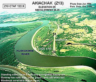
Akiachak is a census-designated place (CDP) in the Bethel Census Area in the U.S. state of Alaska. The population was 627 at the 2010 census, up from 585 in 2000.

<span class="mw-page-title-main">Akiak, Alaska</span> City in Alaska, United States

Akiak(ACK-ee-ack) is a city in Bethel Census Area, Alaska, United States. The population was 462 at the 2020 census, up from 346 in 2010. It is the home of the Akiak Native Community.

<span class="mw-page-title-main">Aniak, Alaska</span> City in Alaska, United States

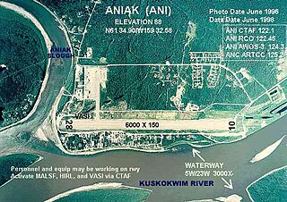
Aniak is a city in the Bethel Census Area in the U.S. state of Alaska. At the 2010 census the population was 501, down from 572 in 2000.

<span class="mw-page-title-main">Bethel, Alaska</span> City in Alaska, United States

Bethel is a city in the U.S. state of Alaska, located on the Kuskokwim River approximately 50 miles (80 km) from where the river discharges into Kuskokwim Bay. It is the largest community in western Alaska and in the Unorganized Borough and the eighth-largest in the state. Bethel has a population of 6,325 as of the 2020 census, up from 6,080 in 2010.

<span class="mw-page-title-main">Goodnews Bay, Alaska</span> City in Alaska, United States

Goodnews Bay is a city in Bethel Census Area, Alaska, United States. As of the 2010 census, the population of the city was 243, up from 230 in 2000.

<span class="mw-page-title-main">Napaskiak, Alaska</span> City in Alaska, United States

Napaskiak is a city in Bethel Census Area, Alaska, United States. At the 2010 census the population was 405, up from 390 in 2000.

<span class="mw-page-title-main">Dillingham, Alaska</span> City in Alaska, United States

Dillingham, also known as Curyung, is a city in Dillingham Census Area, Alaska, United States. Incorporated in 1963, it is an important commercial fishing port on Nushagak Bay. As of the 2020 census, the population of the city was 2,249, down from 2,329 in 2010.

<span class="mw-page-title-main">Tyonek, Alaska</span> Census-designated place in Alaska, United States

Tyonek or Present / New Tyonek is a census-designated place (CDP) in Kenai Peninsula Borough in the U.S. state of Alaska. As of the 2020 census the population was 152, down from 171 in 2010. In 1973, the community formed the Tyonek Native Corporation (TNC) under the Alaska Native Claims Settlement Act and is federally recognized.

<span class="mw-page-title-main">Chignik, Alaska</span> City in Alaska, United States

Chignik is a city in Lake and Peninsula Borough, Alaska, United States. It is two hundred and fifty miles southwest of Kodiak. At the 2020 census the population was 97, up from 91 in 2010.

St. Michael, historically referred to as Saint Michael, is a city in Nome Census Area, Alaska. The population was 401 at the 2010 census, up from 368 in 2000.

<span class="mw-page-title-main">Russian Mission, Alaska</span> City in Alaska, United States

Russian Mission is a city in Kusilvak Census Area, Alaska. It was the location of a fur trading post of the Russian-American Company in 1842. After the sale of Russian-American possessions to the United States in 1867, it was officially named Russian Mission in the early 1900s. The sale of alcohol is prohibited. At the 2010 census the population was 312, up from 296 in 2000.

<span class="mw-page-title-main">Tanana, Alaska</span> City in the Yukon-Koyukuk Census Area in Alaska, United States

Tanana is a city in the Yukon-Koyukuk Census Area in the U.S. state of Alaska. At the 2010 census the population was 246, down from 308 in 2000. It was formerly known as Clachotin, adopted by Canadian French.

Ohagamiut is an abandoned village along the Kuskokwim River in the Bethel Census Area of the southwestern part of the U.S. state of Alaska, located between Crow Village and Kalskag. It was abandoned in the 1940s as residents relocated to Kalskag, Aniak, Bethel and other towns. The village site is located just 3 miles east of Upper Kalskag.

Telida is an unincorporated community located in the Yukon-Koyukuk Census Area in the U.S. state of Alaska. At the 2010 census the population was 3, unchanged from 2000.

Crow Village is an unincorporated community on the Kuskokwim River in the U.S. state of Alaska. There are an estimated six residents.

Georgetown is an unincorporated Alaska Native village located in the Bethel Census Area of the U.S. state of Alaska. The population as of the 2010 census was 2, down from 3 in 2000.

<span class="mw-page-title-main">Nushagak, Alaska</span> Unincorporated community in the state of Alaska, United States

Nushagak was a trade center and settlement near the present-day site of Dillingham, Alaska, United States, at the northern end of Nushagak Bay in northern Bristol Bay. It was located near the confluence of the Wood River and Nushagak Rivers.

<span class="mw-page-title-main">Belkofski, Alaska</span> Unincorporated community in the state of Alaska, United States

Belkofski is an unincorporated community and Alaska Native Village Statistical Area (ANVSA) in the Aleutians East Borough in Alaska. It has been uninhabited since the 1980s, reporting a population of zero in 1990, 2000 and 2010.

<span class="mw-page-title-main">Unga, Alaska</span> Ghost town on Unga Island in the Aleutians (1833-1969)

Unga is a ghost town on Unga Island in the Aleutians East Borough of the U.S. state of Alaska, about two miles west of Sand Point. The island's length is 15 miles (24 km). Unga's altitude is 59 feet (18 m).

Paimuit is an unincorporated community in Kusilvak Census Area, Alaska, United States. It was unpopulated as of 2010, down from two residents in 2000. The nearest town is Hooper Bay, Alaska. The elevation is 30 feet. Paimiut is an Eskimo name meaning, "people of the stream's mouth". The town is on the east bank of the Lithkealik River.

References

  1. U.S. Geological Survey Geographic Names Information System: Napaimute, Alaska
  2. "U.S. Decennial Census". Census.gov. Retrieved June 6, 2013.
  3. "Statistics of the Population of Alaska" (PDF). United States Census Bureau. 1880.
  4. "Geological Survey Professional Paper". 1949.
  5. "Report on Population and Resources of Alaska at the Eleventh Census: 1890" (PDF). United States Census Bureau. Government Printing Office.