Mekoryuk, Alaska

Last updated

Mekoryuk
Mikuryarmiut / Mikuryar
Mekoryuk, Alaska, 1978.jpg
Mekoryuk in 1978
USA Alaska location map.svg
Red pog.svg
Mekoryuk
Location in Alaska
Coordinates: 60°23′21″N166°12′25″W / 60.38917°N 166.20694°W / 60.38917; -166.20694
CountryUnited States
State Alaska
Census Area Bethel
Incorporated September 24, 1969 [1]
Government
   Mayor Larry Nicholson [2]
   State senator Lyman Hoffman (D)
   State rep. Conrad McCormick (D)
Area
[3]
  Total7.08 sq mi (18.34 km2)
  Land7.07 sq mi (18.30 km2)
  Water0.01 sq mi (0.03 km2)
Elevation
7 ft (2 m)
Population
  Total206
  Density29.15/sq mi (11.25/km2)
Time zone UTC-9 (Alaska (AKST))
  Summer (DST) UTC-8 (AKDT)
ZIP code
99630
Area code 907
FIPS code 02-47990
GNIS feature ID 1406211

Mekoryuk (Nunivak Cup'ig: Mikuryarmiut; Central Yup'ik: Mikuryar) is a city located on Nunivak Island in the Bethel Census Area, Alaska, United States. At the 2010 census the population was 191, down from 210 in 2000.

Contents

History

Nunivak Island has been inhabited for 2,000 years by the Nuniwarmiut, or Nunivak Cup'ig people.

The community's first contact with Europeans was in 1821 when explorers from the Russian-American Company arrived on their island. These Russians recorded 400 people living in 16 villages on the Nunivak Island.

While conducting the 1880 United States Census, Ivan Petrof recorded 702 Yup'ik in 9 villages, including 117 people at "Koot", near the site of present-day Mekoryuk. An epidemic in 1900 left only four surviving families in the village.

In the 1930s, the Evangelical Covenant Church was built at Mekoryuk, followed by a school in 1939. People moved to the village from other areas of the island to be near the school. Reindeer herding was introduced in 1920 by an Eskimo-Russian trader. The operation was purchased by the United States government in the 1940s and a slaughterhouse was built in 1945. The reindeer were crossed with caribou from Denali Park. The resulting animals were larger and less tame than other reindeer. 34 musk ox from Greenland were transferred to the Nunivak Island in 1934 in an effort to save the species from extinction. Today, the musk-ox herd numbers around 500, and calves from this herd have been relocated and introduced to other areas of Alaska.

In the mid-20th century, Mekoryuk became the only permanent population center on the island. Until the 1940s, the traditional lifestyle and traditional ceremonies and religious beliefs were practiced.

The 1950s and 1960s brought considerable change. Mekoryuk Airport was built in 1957. When the Territorial Guard was formed, men were sent to Fort Richardson near Anchorage for training. During this time, many families moved to Bethel during the winter to be near the high school, returning in the spring for fishing and sea mammal hunting. A high school was constructed in Mekoryuk in 1978.

Geography

Mekoryuk is located at the mouth of Shoal Bay on the north shore of Nunivak Island in the Bering Sea. The island lies 48 km (30 mi) west of the Alaska coast. According to the United States Census Bureau, the city has a total area of 7.4 square miles (19 km2), of which, 7.4 square miles (19 km2) of it is land and 0.14% is water.

Climate

Mekoryuk has a tundra climate (Köppen: ET), that borders on a subarctic climate (Köppen: Dfc).

Climate data for Mekoryuk, Alaska
MonthJanFebMarAprMayJunJulAugSepOctNovDecYear
Record high °F (°C)41
(5)
38
(3)
48
(9)
48
(9)
70
(21)
71
(22)
77
(25)
70
(21)
63
(17)
54
(12)
46
(8)
47
(8)
77
(25)
Mean daily maximum °F (°C)19.2
(−7.1)
16.8
(−8.4)
21.1
(−6.1)
28.4
(−2.0)
38.6
(3.7)
47.8
(8.8)
53.7
(12.1)
54.5
(12.5)
50.0
(10.0)
39.0
(3.9)
30.4
(−0.9)
20.0
(−6.7)
35.0
(1.7)
Daily mean °F (°C)12.1
(−11.1)
9.7
(−12.4)
13.6
(−10.2)
22.4
(−5.3)
34.0
(1.1)
42.5
(5.8)
48.4
(9.1)
49.6
(9.8)
45.3
(7.4)
34.5
(1.4)
25.4
(−3.7)
13.6
(−10.2)
29.3
(−1.5)
Mean daily minimum °F (°C)5.0
(−15.0)
2.5
(−16.4)
6.0
(−14.4)
16.4
(−8.7)
29.3
(−1.5)
37.1
(2.8)
43.1
(6.2)
44.7
(7.1)
40.6
(4.8)
30.0
(−1.1)
20.3
(−6.5)
7.2
(−13.8)
23.5
(−4.7)
Record low °F (°C)−35
(−37)
−30
(−34)
−30
(−34)
−12
(−24)
0
(−18)
27
(−3)
28
(−2)
23
(−5)
15
(−9)
9
(−13)
−18
(−28)
−39
(−39)
−39
(−39)
Average precipitation inches (mm)0.86
(22)
0.83
(21)
1.11
(28)
0.87
(22)
0.55
(14)
0.81
(21)
1.44
(37)
2.12
(54)
2.23
(57)
1.72
(44)
1.31
(33)
1.14
(29)
14.99
(382)
Average snowfall inches (cm)2.9
(7.4)
6.8
(17)
2.6
(6.6)
3.1
(7.9)
1.7
(4.3)
0.0
(0.0)
0.0
(0.0)
0.7
(1.8)
7.4
(19)
10.7
(27)
10.0
(25)
46.0
(117)
Source: WRCC [4]

Demographics

Historical population
CensusPop.Note
1950 156
1960 24255.1%
1970 2492.9%
1980 160−35.7%
1990 17710.6%
2000 21018.6%
2010 191−9.0%
2020 206[ citation needed ]7.9%
U.S. Decennial Census [5] [ failed verification ]

Mekoryuk first appeared on the 1950 U.S. Census as "Mekoryok." It appeared as the current spelling in 1960. It was formally incorporated in 1969.

As of the census [6] [ failed verification ] of 2000, there were 210 people, 73 households, and 48 families residing in the city. The population density was 28.5 inhabitants per square mile (11.0/km2). There were 96 housing units at an average density of 13.0 per square mile (5.0/km2). The racial makeup of the city was 3.33% White, 90.48% Native American, and 6.19% from two or more races. 0.48% of the population were Hispanic or Latino of any race.

There were 73 households, out of which 31.5% had children under the age of 18 living with them, 45.2% were married couples living together, 15.1% had a female householder with no husband present, and 34.2% were non-families. 32.9% of all households were made up of individuals, and 2.7% had someone living alone who was 65 years of age or older. The average household size was 2.88 and the average family size was 3.77.

In the city, the age distribution of the population shows 32.4% under the age of 18, 6.7% from 18 to 24, 29.0% from 25 to 44, 22.4% from 45 to 64, and 9.5% who were 65 years of age or older. The median age was 36 years. For every 100 females, there were 116.5 males. For every 100 females age 18 and over, there were 136.7 males.

The median income for a household in the city was $30,833, and the median income for a family was $33,750. Males had a median income of $25,417 versus $11,667 for females. The per capita income for the city was $11,958. About 13.7% of families and 21.9% of the population were below the poverty line, including 36.7% of those under the age of eighteen and 15.8% of those 65 or over.

Education

Lower Kuskokwim School District operates the Nuniwarmiut School, K-12. In 1984 the building was constructed. [7]

Health

Sale, importation and possession of alcohol are banned in the village. [8]

Related Research Articles

<span class="mw-page-title-main">Akiak, Alaska</span> City in Alaska, United States

Akiak(ACK-ee-ack) is a city in Bethel Census Area, Alaska, United States. The population was 462 at the 2020 census, up from 346 in 2010. It is the home of the Akiak Native Community.

<span class="mw-page-title-main">Aniak, Alaska</span> City in Alaska, United States

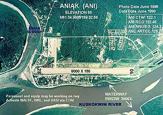
Aniak is a city in the Bethel Census Area in the U.S. state of Alaska. At the 2010 census the population was 501, down from 572 in 2000.

<span class="mw-page-title-main">Bethel, Alaska</span> City in Alaska, United States

Bethel is a city in the U.S. state of Alaska, located on the Kuskokwim River approximately 50 miles (80 km) from where the river discharges into Kuskokwim Bay. It is the largest community in western Alaska and in the Unorganized Borough and the eighth-largest in the state. Bethel has a population of 6,325 as of the 2020 census, up from 6,080 in 2010.

<span class="mw-page-title-main">Chefornak, Alaska</span> City in Alaska, United States

Chefornak is a city in Bethel Census Area, Alaska, United States. At the 2010 census its population was 418, up from 394 in 2000.

<span class="mw-page-title-main">Chuathbaluk, Alaska</span> City in Alaska, United States

Chuathbaluk is a city in Bethel Census Area, Alaska, United States.

<span class="mw-page-title-main">Eek, Alaska</span> City in Alaska, United States

Eek is a city in Bethel Census Area, Alaska, United States. As of the 2020 census there were 404 residents, the majority being Alaska Natives.

<span class="mw-page-title-main">Napakiak, Alaska</span> City in Alaska, United States

Napakiak is a city in Bethel Census Area, Alaska, United States. At the 2010 census the population was 354, up one resident from 353 since 2000.

Nightmute is a city and village in Bethel Census Area, Alaska, United States. The population was 208 at the 2000 census and 280 as of the 2010 census.

<span class="mw-page-title-main">Quinhagak, Alaska</span> City in Alaska, United States

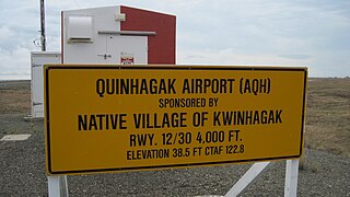
Quinhagak is a city in Bethel Census Area, Alaska, United States. As of the 2020 census, the population of the city is 776, up from 669 in 2010.

<span class="mw-page-title-main">Savoonga, Alaska</span> City in Alaska, United States

Savoonga is a city in Nome Census Area, Alaska. It is located on St. Lawrence Island in the Bering Sea. As of the 2020 census, Savoonga's population was 835, up from 671 in 2010.

<span class="mw-page-title-main">Shaktoolik, Alaska</span> City in Alaska, United States

Shaktoolik is a city in Nome Census Area, Alaska, United States. At the 2010 census the population was 251, up from 230 in 2000. Shaktoolik is one of a number of Alaskan communities threatened by erosion and related global warming effects. The community has been relocated twice.

St. Michael, historically referred to as Saint Michael, is a city in Nome Census Area, Alaska. The population was 401 at the 2010 census, up from 368 in 2000.

<span class="mw-page-title-main">Alakanuk, Alaska</span> City in Alaska, United States

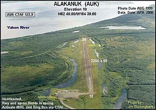
Alakanuk(ah-LUG-uh-nuck) is a second class city in the Kusilvak Census Area of the Unorganized Borough in the western part of the U.S. state of Alaska. As of the 2010 census, the population of the city was 677, up from 652 in 2000.

<span class="mw-page-title-main">Hooper Bay, Alaska</span> Town in Alaska

Hooper Bay is a city in Kusilvak Census Area, Alaska, United States. At the 2020 census the population was 1,375, up from 1,093 in 2010.

Mountain Village is a city in Kusilvak Census Area, Alaska, United States, located on the Yukon River near the Yukon-Kuskokwim Delta. At the 2010 census the population was 813, up from 755 in 2000.

<span class="mw-page-title-main">McGrath, Alaska</span> City in Alaska, United States

McGrath is a city and village on the Kuskokwim River in Alaska, United States. The population was 301 at the 2020 census. Despite its small population, the village is an important transportation and economic hub for the area.

<span class="mw-page-title-main">Nunivak Island</span> Island of Alaska

Nunivak Island is a permafrost-covered volcanic island lying about 30 miles (48 km) offshore from the delta of the Yukon and Kuskokwim rivers in the US state of Alaska, at a latitude of about 60°N. The island is 1,631.97 square miles (4,226.8 km2) in area, making it the second-largest island in the Bering Sea and eighth-largest island in the United States. It is 76.2 kilometers (47.3 mi) long and 106 kilometers (66 mi) wide. It has a population of 191 persons as of the 2010 census, down from 210 in 2000. The island's entire population lives in the north coast city of Mekoryuk.

<span class="mw-page-title-main">Yup'ik</span> Indigenous people of Alaska

The Yupʼik or Yupiaq and Yupiit or Yupiat (pl), also Central Alaskan Yupʼik, Central Yupʼik, Alaskan Yupʼik, are an Indigenous people of western and southwestern Alaska ranging from southern Norton Sound southwards along the coast of the Bering Sea on the Yukon-Kuskokwim Delta and along the northern coast of Bristol Bay as far east as Nushagak Bay and the northern Alaska Peninsula at Naknek River and Egegik Bay. They are also known as Cup'ik by the Chevak Cup'ik dialect-speaking people of Chevak and Cup'ig for the Nunivak Cup'ig dialect-speaking people of Nunivak Island.

Nunivak Cup'ig or just Cup'ig is a language or separate dialect of Central Alaskan Yup'ik spoken in Central Alaska at the Nunivak Island by Nunivak Cup'ig people. The letter "c" in the Yup’ik alphabet is equivalent to the English alphabet "ch".

<span class="mw-page-title-main">Yupʼik cuisine</span> Culinary traditions of Yupik people

Yup'ik cuisine refers to the Eskimo style traditional subsistence food and cuisine of the Yup'ik people from the western and southwestern Alaska. Also known as Cup'ik cuisine for the Chevak Cup'ik dialect speaking Eskimos of Chevak and Cup'ig cuisine for the Nunivak Cup'ig dialect speaking Eskimos of Nunivak Island. This cuisine is traditionally based on meat from fish, birds, sea and land mammals, and normally contains high levels of protein. Subsistence foods are generally considered by many to be nutritionally superior superfoods. Yup’ik diet is different from Alaskan Inupiat, Canadian Inuit, and Greenlandic diets. Fish as food are primary food for Yup'ik Eskimos. Both food and fish called neqa in Yup'ik. Food preparation techniques are fermentation and cooking, also uncooked raw. Cooking methods are baking, roasting, barbecuing, frying, smoking, boiling, and steaming. Food preservation methods are mostly drying and less often frozen. Dried fish is usually eaten with seal oil. The ulu or fan-shaped knife is used for cutting up fish, meat, food, and such.

References

  1. "Directory of Borough and City Officials 1974". Alaska Local Government. XIII (2). Juneau: Alaska Department of Community and Regional Affairs: 53. January 1974.
  2. 2015 Alaska Municipal Officials Directory. Juneau: Alaska Municipal League. 2015. p. 102.
  3. "2020 U.S. Gazetteer Files". United States Census Bureau. Retrieved October 29, 2021.
  4. Mekoryuk, Alaska - Period of Record : 9/6/1923 to 8/28/1987 Archived May 25, 2017, at the Wayback Machine . Retrieved November 10, 2019.
  5. "Census of Population and Housing". Census.gov. Retrieved June 4, 2015.
  6. "U.S. Census website". United States Census Bureau . Retrieved January 31, 2008.
  7. "Nuniwarmiut School." Lower Kuskokwim School District. Retrieved on July 13, 2018.
  8. "Schedule of Local Option Communities" (PDF). Alcoholic Beverage Control Board. Retrieved May 3, 2023.

60°23′21″N166°12′25″W / 60.389278°N 166.207082°W / 60.389278; -166.207082