Akiachak, Alaska

Last updated

Akiachak
Akiacuaq / Akiacuar
Z13-b.jpg
Aerial photograph of Akiachak
AKMap-doton-Akiak.png
Location of Akiachak, Alaska
Coordinates: 60°53′58″N161°24′48″W / 60.89944°N 161.41333°W / 60.89944; -161.41333
Country United States
State Alaska
Census Area Bethel
Government
   State senator Lyman Hoffman (D) [1]
   State rep. Conrad McCormick (D)
Area
[2]
  Total7.01 sq mi (18.16 km2)
  Land7.01 sq mi (18.16 km2)
  Water0.00 sq mi (0.00 km2)
Elevation
13 ft (4 m)
Population
 (2020)
  Total677
  Density97/sq mi (37/km2)
Time zone UTC-9 (Alaska (AKST))
  Summer (DST) UTC-8 (AKDT)
ZIP code
99551
Area code 907
FIPS code 02-00760
GNIS feature ID1398011
Website akiachak.org

Akiachak (ACK-ee-uh-chuck; Central Yupik : Akiacuaq) is a census-designated place (CDP) in the Bethel Census Area in the U.S. state of Alaska. The population was 677 in the 2020 census, [3] up from 627 in 2010, [4] and 585 in 2000.[ citation needed ]

Contents

Geography and climate

Ice road in Akiachak, AK AkiachakAK.jpg
Ice road in Akiachak, AK

Akiachak is located at 60°54′34″N161°25′53″W / 60.90944°N 161.43139°W / 60.90944; -161.43139 (60.909440, -161.43139), [5] Sec. 36, T010N, R069W, Seward Meridian) in the Bethel Recording District.

According to the U.S. Census Bureau, the CDP has a total area of 7.5 square miles (19.5 km2), of which 0.008 square miles (0.02 km2), or 0.11%, is water. [4]

Akiachak is located on the west bank of the Kuskokwim River in the Yukon–Kuskokwim Delta, 18 miles (29 km) northeast of Bethel. The area averages 16 inches (40.64 cm) of precipitation, with snowfall of 50 inches (127.00 cm). Summer temperatures range from 42 to 62 °F (6 to 17 °C). Winter temperatures range from −2 to 19 °F (−19 to −7 °C).

History and culture

The Yup'ik peoples used this region as a seasonal subsistence site. Called Akiakchagamiut in the 1890 census, the village had a population of 43 then. A post office was established in 1934. It incorporated as a second-class city on February 7, 1974. The city government was dissolved in 1987, in favor of traditional village council governance.

A federally recognized Alaska Native tribal entity, the Akiachak Native Community, is located here. Akiachak is a Yup'ik Eskimo village with a fishing and subsistence lifestyle. It has a strong traditional community, and was the first city in Alaska to dissolve its city government in favor of the Native village government. The sale, importation and possession of alcohol are banned in the village. [6] [7]

Demographics

Historical population
CensusPop.Note
1890 43
1900 165283.7%
1940 156
1950 17914.7%
1960 22927.9%
1970 31236.2%
1980 43840.4%
1990 4819.8%
2000 58521.6%
2010 6277.2%
2020 6778.0%
U.S. Decennial Census [ failed verification ]

Akiachak first appeared on the 1890 U.S. Census as the unincorporated native village of "Akiakchagmiut." All 43 of its residents were Native. [8] It returned as Akiachak in 1900. [9] It did not appear again on the census until 1940, when it returned as "Akiachok." [10] It returned in 1950 [11] and every successive census as Akiachak. It formally incorporated in 1974. In 1990, it disincorporated and was assigned the status of census-designated place (CDP). [12]

As of the census [13] of 2000, there were 585 people, 133 households, and 111 families residing in the CDP. The population density was 86.5 inhabitants per square mile (33.4/km2). There were 150 housing units at an average density of 22.2 per square mile (8.6/km2). The racial makeup of the CDP was 3.42% White, 92.31% Native American, and 4.27% from two or more races. 1.20% of the population were Hispanic or Latino of any race.

There were 133 households, out of which 63.9% had children under the age of 18 living with them, 59.4% were married couples living together, 15.0% had a female householder with no husband present, and 15.8% were non-families. 14.3% of all households were made up of individuals, and 2.3% had someone living alone who was 65 years of age or older. The average household size was 4.40 and the average family size was 4.89.

In the CDP, the population was spread out, with 44.4% under the age of 18, 9.6% from 18 to 24, 26.5% from 25 to 44, 14.5% from 45 to 64, and 5.0% who were 65 years of age or older. The median age was 22 years. For every 100 females, there were 121.6 males. For every 100 females age 18 and over, there were 118.1 males.

The median income for a household in the CDP was $35,833, and the median income for a family was $35,288. Males had a median income of $31,667 versus $18,750 for females. The per capita income for the CDP was $8,321. About 16.2% of families and 21.2% of the population were below the poverty line, including 25.7% of those under age 18 and 34.8% of those age 65 or over.

Currently half of the village is hooked up to a plumbing system. The village is currently working to write a grant in order to receive federal funding to plumb the rest of the village who still use honey buckets and must get their water from the river, rain, or snow. The village would like to purchase an incinerator and use the waste heat for public buildings. Electricity is provided by Akiachak Native Community Electric Co. There is one school located in the community, attended by over 200 students each year and growing. Local hospitals or health clinics include Akiachak Health Clinic. Akiachak Health Clinic is a Primary Health facility - they do not have authorization to prescribe drugs, give birth control, or handle much more than colds, small cuts, or routine strep throat treatment which is pervasive in the community. Most live births, birth control, injury, or serious illness will be referred to the Bethel hospital or patients may be air lifted to Anchorage in serious cases. Akiachak is classified as an isolated village. It is found in EMS Region 7A in the Yukon/Kuskokwim Region. Emergency Services have river and air access. Emergency service is provided by a health aide.

Economy and transportation

The majority of year-round employment in Akiachak is in education and other public services. The Yupiit School District, which serves both Akiachak and nearby Tuluksak, has its headquarters located in the community. [14] As part of the district’s curriculum, students can take part in substance harvesting and moose hunts, in order to learn the traditions of the Yupiit communities. [15]

Residents rely on seasonal employment such as commercial fishing, construction and BLM fire-fighting. 70 residents hold commercial fishing permits, and some work at canneries in Bristol Bay. The community is developing a fish processing facility and freezer. Subsistence activities provide most food sources. Poor fish returns since 1997 have significantly affected the community.

Akiachak Airport, a state-owned 1,649-foot (503 m) long by 40-foot (12 m) wide gravel airstrip and public seaplane facilities, provides scheduled and chartered services year-round to Akiachak. Relocation of the Akiachak Airport is planned for the future. Boats, snowmachines and ATVs are used extensively by locals on the Kuskokwim River. A winter trail exists to Bethel (19 mi). Barges deliver bulk fuel and supplies during the summer.

Related Research Articles

<span class="mw-page-title-main">Yupik peoples</span> Indigenous peoples of Alaska and the Russian Far East

The Yupik are a group of Indigenous or Aboriginal peoples of western, southwestern, and southcentral Alaska and the Russian Far East. They are related to the Inuit and Iñupiat. Yupik peoples include the following:

<span class="mw-page-title-main">Bethel Census Area, Alaska</span> Census area in Alaska, United States

Bethel Census Area is a census area in the U.S. state of Alaska. As of the 2020 census, the population is 18,666, up from 17,013 in 2010. It is part of the unorganized borough and therefore has no borough seat. Its largest community is the city of Bethel, which is also the largest city in the unorganized borough.

<span class="mw-page-title-main">Akiak, Alaska</span> City in Alaska, United States

Akiak(ACK-ee-ack) is a city in Bethel Census Area, Alaska, United States. The population was 462 at the 2020 census, up from 346 in 2010. It is the home of the Akiak Native Community.

<span class="mw-page-title-main">Bethel, Alaska</span> City in Alaska, United States

Bethel is a city in the U.S. state of Alaska, located on the Kuskokwim River approximately 50 miles (80 km) from where the river discharges into Kuskokwim Bay. It is the largest community in western Alaska and in the Unorganized Borough and the eighth-largest in the state. Bethel has a population of 6,325 as of the 2020 census, up from 6,080 in 2010.

<span class="mw-page-title-main">Chefornak, Alaska</span> City in Alaska, United States

Chefornak is a city in Bethel Census Area, Alaska, United States. At the 2010 census its population was 418, up from 394 in 2000.

<span class="mw-page-title-main">Crooked Creek, Alaska</span> Census-designated place in Alaska, United States

Crooked Creek is a census-designated place (CDP) in Bethel Census Area, Alaska, United States. As of the 2010 census, the population of the CDP was 105, down from 137 in 2000.

<span class="mw-page-title-main">Eek, Alaska</span> City in Alaska, United States

Eek is a city in Bethel Census Area, Alaska, United States. As of the 2020 census there were 404 residents, the majority being Alaska Natives.

<span class="mw-page-title-main">Kasigluk, Alaska</span> Census-designated place in Alaska, United States

Kasigluk is a census-designated place (CDP) in the Bethel Census Area in the U.S. state of Alaska. At the 2010 census the population was 569, up from 543 in 2000. Kasigluk consists of two smaller villages, called Akiuk and Akula.

<span class="mw-page-title-main">Kongiganak, Alaska</span> CDP in Alaska, United States

Kongiganak is a census-designated place (CDP) in Bethel Census Area, Alaska, United States, and primarily sits on the eastern shore of the Kongiganak River. As of the 2010 census, the population was 439, up from 359 in 2000.

<span class="mw-page-title-main">Kwethluk, Alaska</span> City in Alaska, United States

Kwethluk is a city in Bethel Census Area in the U.S. state of Alaska. At the 2010 census the population was 721, up from 713 in 2000. It is the birthplace of Saint Olga of Alaska

<span class="mw-page-title-main">Mekoryuk, Alaska</span> City in Alaska, United States

Mekoryuk is a city located on Nunivak Island in the Bethel Census Area, Alaska, United States. At the 2010 census the population was 191, down from 210 in 2000.

<span class="mw-page-title-main">Napakiak, Alaska</span> City in Alaska, United States

Napakiak is a city in Bethel Census Area, Alaska, United States. At the 2010 census the population was 354, up one resident from 353 since 2000.

<span class="mw-page-title-main">Oscarville, Alaska</span> CDP in Alaska, United States

Oscarville is a census-designated place (CDP) in Bethel Census Area, Alaska, United States. The population was 70 at the 2010 census, up from 61 in 2000.

<span class="mw-page-title-main">Quinhagak, Alaska</span> City in Alaska, United States

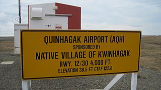
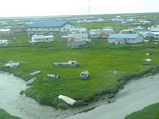
Quinhagak is a city in Bethel Census Area, Alaska, United States. As of the 2020 census, the population of the city is 776, up from 669 in 2010.

<span class="mw-page-title-main">Stony River, Alaska</span> Census-designated place in Alaska, United States

Stony River is a census-designated place (CDP) in Bethel Census Area, Alaska, United States. The population was 54 at the 2010 census, down from 61 in 2000.

<span class="mw-page-title-main">Tuntutuliak, Alaska</span> CDP in Alaska, United States

Tuntutuliak is a census-designated place (CDP) in Bethel Census Area, Alaska, United States. At the 2010 census the population was 408, up from 370 in 2000.

<span class="mw-page-title-main">Tununak, Alaska</span> CDP in Alaska, United States

Tununak(Too-new-nak) is a census-designated place (CDP) in Bethel Census Area, Alaska, United States. At the 2020 census, the population was 411.

Aleneva is a census-designated place in the Kodiak Island Borough in the U.S. state of Alaska. As of the 2010 census, the population was 37, down from 68 in 2000.

<span class="mw-page-title-main">Yup'ik</span> Indigenous people of Alaska

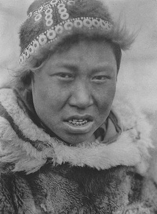
The Yupʼik or Yupiaq and Yupiit or Yupiat (pl), also Central Alaskan Yupʼik, Central Yupʼik, Alaskan Yupʼik, are an Indigenous people of western and southwestern Alaska ranging from southern Norton Sound southwards along the coast of the Bering Sea on the Yukon-Kuskokwim Delta and along the northern coast of Bristol Bay as far east as Nushagak Bay and the northern Alaska Peninsula at Naknek River and Egegik Bay. They are also known as Cup'ik by the Chevak Cup'ik dialect-speaking people of Chevak and Cup'ig for the Nunivak Cup'ig dialect-speaking people of Nunivak Island.

The Yupiit Piciryarait Cultural Center (YPCC), also known as Yupiit Piciryarait Cultural Center and Museum, formerly known as the Yup'ik Museum, Library, and Multipurpose Cultural Center, is a non-profit cultural center of the Yup'ik culture centrally located in Bethel, Alaska near the University of Alaska Fairbanks' Kuskokwim Campus and city offices. The center is a unique facility that combines a museum, a library, and multi-purpose cultural activity center including performing arts space, for cultural gatherings, feasts, celebrations, meetings and classes. and that celebrates the Yup'ik culture and serves as a regional cultural center for Southwest Alaska. The name of Yupiit Piciryarait means "Yup'iks' customs" in Yup'ik language and derived from piciryaraq meaning "manner; custom; habit; tradition; way of life" Construction of this cultural facility was completed in 1995, funded through a State appropriation of federal funds. Total cost for construction was $6.15 million. The center was jointly sponsored by the Association of Village Council Presidents (AVCP) and the University of Alaska Fairbanks (UAF) and at the present the center operated by the UAF's Kuskokwim Campus, AVCP and City of Bethel. The building houses three community resources: the Consortium Library, the Yup'ik Museum, and the Multi-purpose room or auditorium. The mission of the center is promote, preserve and develop the traditions of the Yup'ik through traditional and non-traditional art forms of the Alaska Native art, including arts and crafts, performance arts, education, and Yup'ik language. The center also supports local artists and entrepreneurs.

References

  1. "Senator Lyman Hoffman". Alaska Senate Majority. Alaskasenate.org. Archived from the original on April 8, 2020. Retrieved November 16, 2019.
  2. "2020 U.S. Gazetteer Files". United States Census Bureau. Retrieved October 27, 2021.
  3. "Explore Census Data". data.census.gov. Retrieved September 6, 2023.
  4. 1 2 "Geographic Identifiers: 2010 Demographic Profile Data (G001): Akiachak CDP, Alaska". U.S. Census Bureau, American Factfinder. Archived from the original on February 12, 2020. Retrieved September 20, 2013.
  5. "US Gazetteer files: 2010, 2000, and 1990". United States Census Bureau. February 12, 2011. Retrieved April 23, 2011.
  6. "Anaktuvuk Pass". National Park Service. Retrieved February 20, 2019.
  7. "Schedule of Local Option Communities" (PDF). Alcoholic Beverage Control Board. Retrieved May 3, 2023.
  8. "Report on Population and Resources of Alaska at the Eleventh Census: 1890" (PDF). United States Census Bureau. Government Printing Office.
  9. "Statistics of Population - Populations of States and Territories by Minor Civil Divisions: 1890 and 1900" (PDF). 1900. p. 426.
  10. "Alaska - Number of Inhabitants" (PDF). United States Census Bureau. 1940.
  11. "Number of Inhabitants - Alaska" (PDF). United States Census Bureau. 1950.
  12. "1990 Census of Population and Housing - Summary Social, Economic, and Housing Characteristics - Alaska" (PDF). United States Census Bureau. Archived from the original (PDF) on February 23, 2014.
  13. "U.S. Census website". United States Census Bureau . Retrieved January 31, 2008.
  14. "Home". www.yupiit.org. Retrieved September 6, 2023.
  15. "An Alaska district aligns its school year with traditional subsistence harvests". WGCU PBS & NPR for Southwest Florida. August 30, 2023. Retrieved September 6, 2023.

60°54′34″N161°25′53″W / 60.909440°N 161.43139°W / 60.909440; -161.43139