National Register of Historic Places listings in Columbia County, Arkansas

Last updated

Location of Columbia County in Arkansas Map of Arkansas highlighting Columbia County.svg
Location of Columbia County in Arkansas

This is a list of the National Register of Historic Places listings in Columbia County, Arkansas.

Contents

This is intended to be a complete list of the properties and districts on the National Register of Historic Places in Columbia County, Arkansas, United States. The locations of National Register properties and districts for which the latitude and longitude coordinates are included below, may be seen in a map. [1]

There are 24 properties and districts listed on the National Register in the county.

Contents: Counties in Arkansas


    This National Park Service list is complete through NPS recent listings posted May 10, 2024. [2]

Current listings

[3] Name on the Register [4] ImageDate listed [5] Location City or townDescription
1 W. H. Allen House
W. H. Allen House W. H. Allen House.JPG
W. H. Allen House
October 14, 1976
(#76000395)
Northwest of Spotville off Highway 98
33°11′31″N93°01′25″W / 33.191944°N 93.023611°W / 33.191944; -93.023611 (W. H. Allen House)
Spotville
2 Columbia County Courthouse
Columbia County Courthouse Columbia County, AR, Courthouse, Magnolia, IMG 2309.JPG
Columbia County Courthouse
April 15, 1978
(#78000580)
Court Sq.
33°16′01″N93°14′27″W / 33.266944°N 93.240833°W / 33.266944; -93.240833 (Columbia County Courthouse)
Magnolia
3 Columbia County Jail
Columbia County Jail Columbia County Jail.JPG
Columbia County Jail
December 22, 1982
(#82000802)
Calhoun and Jefferson Sts.
33°15′55″N93°14′30″W / 33.265278°N 93.241667°W / 33.265278; -93.241667 (Columbia County Jail)
Magnolia
4 Harvey C. Couch School
Harvey C. Couch School Harvey C. Couch School.JPG
Harvey C. Couch School
June 8, 1993
(#93000482)
Northeast of the junction of County Roads 11 (Calhoun Rd.) and 25
33°13′12″N93°09′12″W / 33.22°N 93.153333°W / 33.22; -93.153333 (Harvey C. Couch School)
Calhoun
5 Couch-Marshall House
Couch-Marshall House Couch-Marshall House.JPG
Couch-Marshall House
July 24, 1992
(#92000955)
505 W. Monroe St.
33°15′56″N93°14′41″W / 33.265556°N 93.244722°W / 33.265556; -93.244722 (Couch-Marshall House)
Magnolia
6 Cross and Nelson Hall Historic District
Cross and Nelson Hall Historic District Cross and Nelson Hall Historic District, 1 of 2.JPG
Cross and Nelson Hall Historic District
January 20, 2010
(#09001240)
Southern Arkansas University campus at 100 E. University
33°17′25″N93°14′07″W / 33.290272°N 93.235239°W / 33.290272; -93.235239 (Cross and Nelson Hall Historic District)
Magnolia
7 Dolph Camp, Bussey and Peace Halls Historic District
Dolph Camp, Bussey and Peace Halls Historic District Dolph Camp, Bussey and Peace Halls Historic District, 1 of 2.JPG
Dolph Camp, Bussey and Peace Halls Historic District
January 29, 2013
(#12001231)
East side of Lane Dr., Southern Arkansas University
33°17′26″N93°14′03″W / 33.290503°N 93.234274°W / 33.290503; -93.234274 (Dolph Camp, Bussey and Peace Halls Historic District)
Magnolia
8 Frog Level
Frog Level Frog Level.JPG
Frog Level
September 22, 1972
(#72000201)
West of Magnolia off Columbia Rd. [6]
33°16′44″N93°21′13″W / 33.278889°N 93.353542°W / 33.278889; -93.353542 (Frog Level)
Bussey
9 Greene-Talbot-Talley Halls Historic District March 13, 2023
(#100008558)
South of North Washington and East Lane Dr. intersection
33°17′34″N93°14′10″W / 33.2928°N 93.2360°W / 33.2928; -93.2360 (Greene-Talbot-Talley Halls Historic District)
Magnolia
10 Greek Amphitheatre
Greek Amphitheatre Greek Amphitheatre, Magnolia Arkansas.JPG
Greek Amphitheatre
June 1, 2005
(#05000488)
Junction of East Lane Dr., E. University St., and Crescent Dr.
33°17′27″N93°14′04″W / 33.290833°N 93.234444°W / 33.290833; -93.234444 (Greek Amphitheatre)
Magnolia
11 Dr. H.A. Longino House
Dr. H.A. Longino House Dr. H.A. Longino House.JPG
Dr. H.A. Longino House
June 14, 1982
(#82002098)
317 W. Main St.
33°16′00″N93°14′36″W / 33.266667°N 93.243333°W / 33.266667; -93.243333 (Dr. H.A. Longino House)
Magnolia
12 Magnesia Springs Campground May 9, 2024
(#100010314)
Logoly State Park
33°20′51″N93°11′06″W / 33.3474°N 93.1850°W / 33.3474; -93.1850 (Magnesia Springs Campground)
Magnolia
13 Magnolia Colored School Historic District
Magnolia Colored School Historic District Magnolia Colored School Historic District.JPG
Magnolia Colored School Historic District
January 22, 2014
(#13001103)
611 S. Madison
33°15′43″N93°14′37″W / 33.26202°N 93.243602°W / 33.26202; -93.243602 (Magnolia Colored School Historic District)
Magnolia
14 Magnolia Commercial Historic District
Magnolia Commercial Historic District Downtown Magnolia, AR IMG 2313.JPG
Magnolia Commercial Historic District
May 20, 2008
(#08000435)
Roughly bounded by Madison Ave., Calhoun St., Jackson Ave., and Union St.
33°16′02″N93°14′27″W / 33.267125°N 93.240831°W / 33.267125; -93.240831 (Magnolia Commercial Historic District)
Magnolia
15 McNeil Overpass May 13, 2021
(#100006535)
US 79 over the Union Pacific RR.
33°20′54″N93°12′03″W / 33.3483°N 93.2008°W / 33.3483; -93.2008 (McNeil Overpass)
McNeil
16 Mt. Prospect Methodist Church
Mt. Prospect Methodist Church Mount Prospect.jpg
Mt. Prospect Methodist Church
March 22, 1990
(#90000428)
Junction of County Roads 61 and 446
33°22′09″N93°04′32″W / 33.3692°N 93.0756°W / 33.3692; -93.0756 (Mt. Prospect Methodist Church)
Richland
17 Old Alexander House
Old Alexander House Alexander house before being relocated to Southern Arkansas University.jpg
Old Alexander House
January 18, 1979
(#79000435)
Southern Arkansas University campus
33°19′24″N93°08′26″W / 33.3233°N 93.1406°W / 33.3233; -93.1406 (Old Alexander House)
Magnolia Moved from a rural setting in 2017.
18 Overstreet Hall
Overstreet Hall Overstreet Hall.JPG
Overstreet Hall
January 26, 2016
(#15000992)
NW. of jct. of E. University & N. Jackson Sts., Southern Arkansas University campus
33°17′23″N93°14′10″W / 33.2897°N 93.2361°W / 33.2897; -93.2361 (Overstreet Hall)
Magnolia
19 Ozmer House
Ozmer House Ozmer House.JPG
Ozmer House
November 20, 1986
(#86003226)
Southern Arkansas University farm, U.S. Route 82 Bypass
33°17′16″N93°13′13″W / 33.2878°N 93.2203°W / 33.2878; -93.2203 (Ozmer House)
Magnolia vicinity
20 President's House
President's House President's House.JPG
President's House
May 28, 2013
(#13000315)
East Farm Road east of Washington Street, Southern Arkansas University
33°17′46″N93°13′59″W / 33.2960°N 93.2331°W / 33.2960; -93.2331 (President's House)
Magnolia
21 The Rushton Clinic
The Rushton Clinic The Rushton Clinic.JPG
The Rushton Clinic
May 28, 2013
(#13000316)
219 North Washington Street
33°16′09″N93°14′26″W / 33.2691°N 93.2405°W / 33.2691; -93.2405 (The Rushton Clinic)
Magnolia
22 William H. Smith House
William H. Smith House W. H. Smith house in Fall.jpg
William H. Smith House
November 27, 1992
(#92001630)
North of the junction of Highway 98 and County Road 85
33°07′12″N93°03′12″W / 33.12°N 93.0533°W / 33.12; -93.0533 (William H. Smith House)
Atlanta
23 Kate Turner House
Kate Turner House Kate Turner House.JPG
Kate Turner House
August 26, 1982
(#82002099)
709 W. Main St.
33°16′00″N93°14′53″W / 33.2667°N 93.2481°W / 33.2667; -93.2481 (Kate Turner House)
Magnolia
24 Waldo Water Tower
Waldo Water Tower Waldo Water Tower.JPG
Waldo Water Tower
May 29, 2007
(#07000472)
E. Main St., west of its junction with N. Skimmer
33°21′11″N93°16′56″W / 33.353°N 93.2822°W / 33.353; -93.2822 (Waldo Water Tower)
Waldo

Former listings

[3] Name on the RegisterImageDate listedDate removedLocation City or townDescription
1 Bank of Waldo December 22, 1982
(#82000801)
September 17, 1999Locust and Main Sts.
Waldo Demolished
2 Caraway Hall February 25, 1993
(#93000088)
August 11, 1999 Southern Arkansas University, Adjacent to E. Lane Dr.
Magnolia Demolished in 1994 [7]
3 Louisiana and Northwest Railroad Depot - Magnolia June 11, 1992
(#92000614)
March 31, 2000N side of Main St., between Clay and Walnut Sts.
Magnolia

See also

Related Research Articles

<span class="mw-page-title-main">National Register of Historic Places listings in Cuyahoga County, Ohio</span>

This is a list of the National Register of Historic Places listings in Cuyahoga County, Ohio.

<span class="mw-page-title-main">National Register of Historic Places listings in Dauphin County, Pennsylvania</span>

This is a list of the National Register of Historic Places listings in Dauphin County, Pennsylvania.

<span class="mw-page-title-main">National Register of Historic Places listings in Alachua County, Florida</span>

This is a list of the National Register of Historic Places listings in Alachua County, Florida.

<span class="mw-page-title-main">National Register of Historic Places listings in Delaware County, Ohio</span>

This is a list of the National Register of Historic Places listings in Delaware County, Ohio.

<span class="mw-page-title-main">National Register of Historic Places listings in Licking County, Ohio</span>

This is a list of the National Register of Historic Places listings in Licking County, Ohio.

<span class="mw-page-title-main">National Register of Historic Places listings in Greene County, Ohio</span>

This is a list of the National Register of Historic Places listings in Greene County, Ohio.

<span class="mw-page-title-main">National Register of Historic Places listings in San Bernardino County, California</span>

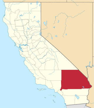
This is a list of the National Register of Historic Places listings in San Bernardino County, California.

<span class="mw-page-title-main">National Register of Historic Places listings in Beaver County, Pennsylvania</span>

This is a list of the National Register of Historic Places listings in Beaver County, Pennsylvania.

<span class="mw-page-title-main">National Register of Historic Places listings in Marion County, Ohio</span>

This is a list of the National Register of Historic Places listings in Marion County, Ohio.

<span class="mw-page-title-main">National Register of Historic Places listings in Hocking County, Ohio</span>

This is a list of the National Register of Historic Places listings in Hocking County, Ohio.

<span class="mw-page-title-main">National Register of Historic Places listings in Pulaski County, Arkansas</span>

This is a list of the National Register of Historic Places listings in Pulaski County, Arkansas.

<span class="mw-page-title-main">National Register of Historic Places listings in Conway County, Arkansas</span>

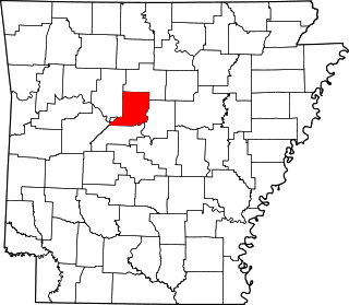
This is a list of the National Register of Historic Places listings in Conway County, Arkansas.

<span class="mw-page-title-main">National Register of Historic Places listings in Cross County, Arkansas</span>

This is a list of the National Register of Historic Places listings in Cross County, Arkansas.

<span class="mw-page-title-main">National Register of Historic Places listings in Garland County, Arkansas</span>

This is a list of the National Register of Historic Places listings in Garland County, Arkansas.

<span class="mw-page-title-main">National Register of Historic Places listings in Hempstead County, Arkansas</span>

This is a list of the National Register of Historic Places listings in Hempstead County, Arkansas.

<span class="mw-page-title-main">National Register of Historic Places listings in Hot Spring County, Arkansas</span>

This is a list of the National Register of Historic Places listings in Hot Spring County, Arkansas.

<span class="mw-page-title-main">National Register of Historic Places listings in Lawrence County, Arkansas</span>

This is a list of the National Register of Historic Places listings in Lawrence County, Arkansas.

<span class="mw-page-title-main">National Register of Historic Places listings in Scott County, Arkansas</span>

This is a list of the National Register of Historic Places listings in Scott County, Arkansas.

<span class="mw-page-title-main">National Register of Historic Places listings in Randolph County, Arkansas</span>

This is a list of the National Register of Historic Places listings in Randolph County, Arkansas.

<span class="mw-page-title-main">National Register of Historic Places listings in Sebastian County, Arkansas</span>

This is a list of the National Register of Historic Places listings in Sebastian County, Arkansas.

References

  1. The latitude and longitude information provided in this table was derived originally from the National Register Information System, which has been found to be fairly accurate for about 99% of listings. Some locations in this table may have been corrected to current GPS standards.
  2. National Park Service, United States Department of the Interior, "National Register of Historic Places: Weekly List Actions", retrieved May 10, 2024.
  3. 1 2 Numbers represent an alphabetical ordering by significant words. Various colorings, defined here, differentiate National Historic Landmarks and historic districts from other NRHP buildings, structures, sites or objects.
  4. "National Register Information System". National Register of Historic Places . National Park Service. March 13, 2009.
  5. The eight-digit number below each date is the number assigned to each location in the National Register Information System database, which can be viewed by clicking the number.
  6. Location derived from NRIS-provided coords; the NRIS lists the site as "Address unknown at this time".
  7. Southern Arkansas University