National Register of Historic Places listings in Ashley County, Arkansas

Last updated

Location of Ashley County in Arkansas Map of Arkansas highlighting Ashley County.svg
Location of Ashley County in Arkansas

This is a list of the National Register of Historic Places listings in Ashley County, Arkansas.

Contents

This is intended to be a complete list of the properties on the National Register of Historic Places in Ashley County, Arkansas, United States. The locations of National Register properties for which the latitude and longitude coordinates are included below, may be seen in a map. [1]

There are 28 properties listed on the National Register in the county. Another two properties were once listed but have been removed.

Contents: Counties in Arkansas


    This National Park Service list is complete through NPS recent listings posted January 26, 2024. [2]

Map all coordinates using: OpenStreetMap

Current listings

[3] Name on the Register [4] ImageDate listed [5] Location City or townDescription
1 Ashley County Courthouse
Ashley County Courthouse Ashley county courthouse 001.jpg
Ashley County Courthouse
September 26, 2023
(#100009391)
205 East Jefferson St.
33°13′37″N91°47′45″W / 33.2270°N 91.7958°W / 33.2270; -91.7958 (Ashley County Courthouse)
Hamburg
2 Bethel Cemetery June 5, 2017
(#100001003)
At the end of Bethel Rd., 3.5 miles (5.6 km) N. of the jct. of AR 52 & AR 53
33°12′56″N91°55′21″W / 33.215532°N 91.922496°W / 33.215532; -91.922496 (Bethel Cemetery)
Crossett vicinity
3 W.R. Bunckley House March 17, 1994
(#94000189)
509 E. Parker St.
33°13′23″N91°44′12″W / 33.223056°N 91.736667°W / 33.223056; -91.736667 (W.R. Bunckley House)
Hamburg
4 Crossett Experimental Forest Building No. 2
Crossett Experimental Forest Building No. 2 Crossett Experimental Forest Building No. 2.JPG
Crossett Experimental Forest Building No. 2
October 20, 1993
(#93001084)
Highway 133 south of Crossett
33°02′03″N91°56′22″W / 33.034167°N 91.939444°W / 33.034167; -91.939444 (Crossett Experimental Forest Building No. 2)
Crossett
5 Crossett Experimental Forest Building No. 6
Crossett Experimental Forest Building No. 6 Crossett Experimental Forest Building No. 6JPG.JPG
Crossett Experimental Forest Building No. 6
October 20, 1993
(#93001085)
Highway 133 south of Crossett
33°01′58″N91°56′19″W / 33.032778°N 91.938611°W / 33.032778; -91.938611 (Crossett Experimental Forest Building No. 6)
Crossett
6 Crossett Experimental Forest Building No. 8
Crossett Experimental Forest Building No. 8 Crossett Experimental Forest Building No. 8.JPG
Crossett Experimental Forest Building No. 8
October 20, 1993
(#93001086)
Highway 133 south of Crossett
33°02′00″N91°56′19″W / 33.033333°N 91.938611°W / 33.033333; -91.938611 (Crossett Experimental Forest Building No. 8)
Crossett
7 Crossett Methodist Church
Crossett Methodist Church Crossett United Methodist Church.JPG
Crossett Methodist Church
February 17, 2010
(#10000018)
500 Main St.
33°07′47″N91°57′41″W / 33.129597°N 91.9614°W / 33.129597; -91.9614 (Crossett Methodist Church)
Crossett
8 Crossett Municipal Auditorium
Crossett Municipal Auditorium Crossett Auditorium.JPG
Crossett Municipal Auditorium
September 20, 2007
(#07000965)
1100 Main St.
33°07′16″N91°57′40″W / 33.121111°N 91.961111°W / 33.121111; -91.961111 (Crossett Municipal Auditorium)
Crossett
9 Crossett Municipal Building
Crossett Municipal Building Crossett Municipal Building, front.JPG
Crossett Municipal Building
September 20, 2007
(#07000966)
307-309 Main St.
33°07′41″N91°57′41″W / 33.128056°N 91.961389°W / 33.128056; -91.961389 (Crossett Municipal Building)
Crossett
10 Crossett Post Office
Crossett Post Office Crossett Post Office.JPG
Crossett Post Office
January 8, 2003
(#02001673)
125 Main St.
33°08′02″N91°57′39″W / 33.133889°N 91.960833°W / 33.133889; -91.960833 (Crossett Post Office)
Crossett
11 Edward C. Crossett Youth Center January 24, 2024
(#100009337)
300 North Dr. Martin Luther King Jr. Dr.
33°07′56″N91°58′02″W / 33.1321°N 91.9671°W / 33.1321; -91.9671 (Edward C. Crossett Youth Center)
Crossett
12 Crossroads Fire Tower
Crossroads Fire Tower Crossroads Fire Tower.JPG
Crossroads Fire Tower
March 2, 2006
(#06000078)
2262 Highway 133 N.
33°13′58″N91°55′28″W / 33.232778°N 91.924444°W / 33.232778; -91.924444 (Crossroads Fire Tower)
Hamburg
13 Dean House
Dean House Dean House.jpg
Dean House
December 22, 1982
(#82000797)
Off U.S. Highway 165
33°14′22″N91°30′46″W / 33.239444°N 91.512778°W / 33.239444; -91.512778 (Dean House)
Portland
14 First United Methodist Church
First United Methodist Church First United Methodist Church, Hamburg, AR.jpg
First United Methodist Church
April 27, 1992
(#92000388)
204 S. Main
33°13′29″N91°47′52″W / 33.224722°N 91.797778°W / 33.224722; -91.797778 (First United Methodist Church)
Hamburg
15 John P. Fisher House
John P. Fisher House John P. Fisher House.jpg
John P. Fisher House
September 29, 1995
(#95001141)
Junction of Highway 160 and County Road 50, west of Bayou Bartholomew Bridge
33°14′19″N91°32′16″W / 33.238611°N 91.537778°W / 33.238611; -91.537778 (John P. Fisher House)
Portland
16 Hamburg Cemetery Historic Section
Hamburg Cemetery Historic Section Hamburg Cemetery Historic Section.JPG
Hamburg Cemetery Historic Section
September 23, 2011
(#11000684)
800 E. Parker St.
33°13′26″N91°47′10″W / 33.223889°N 91.786111°W / 33.223889; -91.786111 (Hamburg Cemetery Historic Section)
Hamburg
17 Hamburg Commercial Historic District
Hamburg Commercial Historic District Hamburg Commercial Historic District, 1 of 5.jpg
Hamburg Commercial Historic District
March 23, 2009
(#08001333)
100-200 block of E. Adams, 100 block of N. Mulberry, 201 S. Mulberry, and 201 and 205 N. Main St.
33°13′35″N91°47′48″W / 33.226389°N 91.796667°W / 33.226389; -91.796667 (Hamburg Commercial Historic District)
Hamburg
18 Hamburg Presbyterian Church
Hamburg Presbyterian Church Hamburg Presbyterian Church.JPG
Hamburg Presbyterian Church
May 14, 1991
(#91000589)
Junction of Cherry and Lincoln Sts.
33°13′32″N91°47′40″W / 33.225556°N 91.794444°W / 33.225556; -91.794444 (Hamburg Presbyterian Church)
Hamburg
19 Dr. M.C. Hawkins House
Dr. M.C. Hawkins House Dr. M. C. Hawkins House.jpg
Dr. M.C. Hawkins House
March 28, 1996
(#96000310)
4684 Highway 8
33°07′14″N91°32′53″W / 33.120556°N 91.548056°W / 33.120556; -91.548056 (Dr. M.C. Hawkins House)
Parkdale
20 Naff House
Naff House Naff House.JPG
Naff House
July 24, 1992
(#92000957)
Northwestern corner of the junction of 3rd Ave. and Fir St.
33°14′18″N91°30′10″W / 33.238333°N 91.502778°W / 33.238333; -91.502778 (Naff House)
Portland
21 Parkdale Baptist Church-AS0051
Parkdale Baptist Church-AS0051 Parkdale Baptist Church-AS0051.JPG
Parkdale Baptist Church-AS0051
January 24, 2007
(#06001285)
127 Bride St.
33°07′22″N91°32′57″W / 33.122778°N 91.549167°W / 33.122778; -91.549167 (Parkdale Baptist Church-AS0051)
Parkdale
22 Parkdale Methodist Church
Parkdale Methodist Church Parkdale Methodist Church.JPG
Parkdale Methodist Church
June 5, 2007
(#07000505)
S. Church St.
33°07′12″N91°32′58″W / 33.12°N 91.549444°W / 33.12; -91.549444 (Parkdale Methodist Church)
Parkdale
23 Portland United Methodist Church
Portland United Methodist Church Portland United Methodist Church.JPG
Portland United Methodist Church
October 18, 2006
(#06000942)
300 N. Main St.
33°14′28″N91°30′41″W / 33.241111°N 91.511389°W / 33.241111; -91.511389 (Portland United Methodist Church)
Portland
24 Pugh House
Pugh House Pugh House.JPG
Pugh House
December 22, 1982
(#82000798)
Off U.S. Highway 165
33°14′19″N91°30′48″W / 33.238611°N 91.513333°W / 33.238611; -91.513333 (Pugh House)
Portland
25 Sumner-White Dipping Vat March 2, 2006
(#06000087)
4 miles east of the junction of U.S. Highway 82 and County Road 69; 0.5 miles south in the woods at the Hunt Camp
33°21′05″N91°39′14″W / 33.351389°N 91.653889°W / 33.351389; -91.653889 (Sumner-White Dipping Vat)
Hamburg
26 Watson House
Watson House Watson House Cheery Street.JPG
Watson House
December 28, 1977
(#77000242)
300 N. Cherry
33°13′37″N91°47′40″W / 33.226944°N 91.794444°W / 33.226944; -91.794444 (Watson House)
Hamburg
27 Watson-Sawyer House
Watson-Sawyer House Watson-Sawyer House.JPG
Watson-Sawyer House
December 6, 1975
(#75000373)
502 E. Parker St.
33°13′25″N91°47′36″W / 33.223611°N 91.793333°W / 33.223611; -91.793333 (Watson-Sawyer House)
Hamburg
28 Dr. Robert George Williams House
Dr. Robert George Williams House Dr. Robert George Williams House.JPG
Dr. Robert George Williams House
October 4, 1984
(#84000002)
Highways 8 and 209
33°07′17″N91°32′56″W / 33.121389°N 91.548889°W / 33.121389; -91.548889 (Dr. Robert George Williams House)
Parkdale

Former listings

[3] Name on the RegisterImageDate listedDate removedLocationCity or townDescription
1 Greenview Cafe January 19, 2005
(#04001507)
January 23, 20083rd Avenue and Arkansas Street
33°07′56″N91°57′52″W / 33.1323°N 91.96431°W / 33.1323; -91.96431 (Greenview Cafe)
Crossett
2 Wiggins Cabin September 30, 1982
(#82002093)
December 28, 2002City Park
Crossett Destroyed by fire August 24, 2002 [6]

See also

Related Research Articles

<span class="mw-page-title-main">National Register of Historic Places listings in Clark County, Arkansas</span>

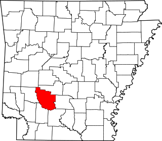
This is a list of the National Register of Historic Places listings in Clark County, Arkansas.

<span class="mw-page-title-main">National Register of Historic Places listings in Cross County, Arkansas</span>

This is a list of the National Register of Historic Places listings in Cross County, Arkansas.

<span class="mw-page-title-main">National Register of Historic Places listings in Franklin County, Arkansas</span>

This is a list of the National Register of Historic Places listings in Franklin County, Arkansas.

<span class="mw-page-title-main">National Register of Historic Places listings in Cleveland County, Arkansas</span>

This is a list of the National Register of Historic Places listings in Cleveland County, Arkansas.

<span class="mw-page-title-main">National Register of Historic Places listings in Garland County, Arkansas</span>

This is a list of the National Register of Historic Places listings in Garland County, Arkansas.

<span class="mw-page-title-main">National Register of Historic Places listings in Dallas County, Arkansas</span>

This is a list of the National Register of Historic Places listings in Dallas County, Arkansas.

<span class="mw-page-title-main">National Register of Historic Places listings in Howard County, Arkansas</span>

This is a list of the National Register of Historic Places listings in Howard County, Arkansas.

<span class="mw-page-title-main">National Register of Historic Places listings in Independence County, Arkansas</span>

This is a list of the National Register of Historic Places listings in Independence County, Arkansas.

<span class="mw-page-title-main">National Register of Historic Places listings in Jackson County, Arkansas</span>

This is a list of the National Register of Historic Places listings in Jackson County, Arkansas.

<span class="mw-page-title-main">National Register of Historic Places listings in Johnson County, Arkansas</span>

This is a list of the National Register of Historic Places listings in Johnson County, Arkansas.

<span class="mw-page-title-main">National Register of Historic Places listings in Lonoke County, Arkansas</span>

This is a list of the National Register of Historic Places listings in Lonoke County, Arkansas.

<span class="mw-page-title-main">National Register of Historic Places listings in Nevada County, Arkansas</span>

This is a list of the National Register of Historic Places listings in Nevada County, Arkansas.

<span class="mw-page-title-main">National Register of Historic Places listings in Ouachita County, Arkansas</span>

This is a list of the National Register of Historic Places listings in Ouachita County, Arkansas.

<span class="mw-page-title-main">National Register of Historic Places listings in Phillips County, Arkansas</span>

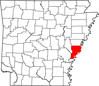
This is a list of the National Register of Historic Places listings in Phillips County, Arkansas.

<span class="mw-page-title-main">National Register of Historic Places listings in Miller County, Arkansas</span>

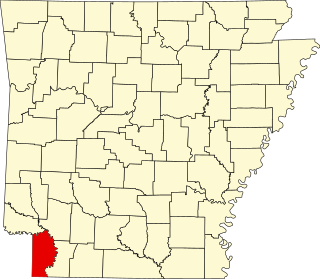
This is a list of the National Register of Historic Places listings in Miller County, Arkansas.

<span class="mw-page-title-main">National Register of Historic Places listings in Saline County, Arkansas</span>

This is a list of the National Register of Historic Places listings in Saline County, Arkansas.

<span class="mw-page-title-main">National Register of Historic Places listings in Pike County, Arkansas</span>

This is a list of the National Register of Historic Places listings in Pike County, Arkansas.

<span class="mw-page-title-main">National Register of Historic Places listings in Polk County, Arkansas</span>

This is a list of the National Register of Historic Places listings in Polk County, Arkansas.

<span class="mw-page-title-main">National Register of Historic Places listings in Searcy County, Arkansas</span>

This is a list of the National Register of Historic Places listings in Searcy County, Arkansas.

<span class="mw-page-title-main">National Register of Historic Places listings in White County, Arkansas</span>

This is a list of the National Register of Historic Places listings in White County, Arkansas.

References

  1. The latitude and longitude information provided in this table was derived originally from the National Register Information System, which has been found to be fairly accurate for about 99% of listings. Some locations in this table may have been corrected to current GPS standards.
  2. National Park Service, United States Department of the Interior, "National Register of Historic Places: Weekly List Actions", retrieved January 26, 2024.
  3. 1 2 Numbers represent an alphabetical ordering by significant words. Various colorings, defined here, differentiate National Historic Landmarks and historic districts from other NRHP buildings, structures, sites or objects.
  4. "National Register Information System". National Register of Historic Places . National Park Service. March 13, 2009.
  5. The eight-digit number below each date is the number assigned to each location in the National Register Information System database, which can be viewed by clicking the number.
  6. National Archives