National Register of Historic Places listings in Craighead County, Arkansas

Last updated

Location of Craighead County in Arkansas Map of Arkansas highlighting Craighead County.svg
Location of Craighead County in Arkansas

This is a list of the National Register of Historic Places listings in Craighead County, Arkansas.

Contents

This is intended to be a complete list of the properties and districts on the National Register of Historic Places in Craighead County, Arkansas, United States. The locations of National Register properties and districts for which the latitude and longitude coordinates are included below, may be seen in a map. [1]

There are 23 properties and districts listed on the National Register in the county, and two former listings. One of the two delisted properties was delisted and relisted under a different name, and then delisted again.

Contents: Counties in Arkansas


    This National Park Service list is complete through NPS recent listings posted May 24, 2024. [2]

Current listings

[3] Name on the Register [4] ImageDate listed [5] Location City or townDescription
1 Arkansas State College Historic District May 16, 2024
(#100010315)
2405 Aggie Road
35°50′33″N90°40′44″W / 35.8425°N 90.6788°W / 35.8425; -90.6788 (Arkansas State College Historic District)
Jonesboro
2 Bay Mounds February 14, 1978
(#78000582)
Address Restricted
Bay
3 Bell House
Bell House Jonesboro AR historic Bell House 303 Cherry St.JPG
Bell House
November 7, 1976
(#76000398)
303 W. Cherry St.
35°50′02″N90°42′26″W / 35.8339°N 90.7072°W / 35.8339; -90.7072 (Bell House)
Jonesboro
4 Berger House
Berger House Jonesboro, AR 009.jpg
Berger House
November 7, 1996
(#96001272)
1120 S. Main St.
35°49′55″N90°42′17″W / 35.8319°N 90.7047°W / 35.8319; -90.7047 (Berger House)
Jonesboro
5 Berger-Graham House October 10, 1985
(#85003006)
1327 S. Main St.
35°49′43″N90°42′19″W / 35.8286°N 90.7053°W / 35.8286; -90.7053 (Berger-Graham House)
Jonesboro
6 Bridge Street Bridge September 10, 2020
(#100005580)
Bridge St. between Johnson and Cate Aves.
35°50′36″N90°41′58″W / 35.8434°N 90.6995°W / 35.8434; -90.6995 (Bridge Street Bridge)
Jonesboro
7 US Sen. Hattie Caraway Gravesite
US Sen. Hattie Caraway Gravesite Oaklawn Cemetery Jonesboro AR 012.jpg
US Sen. Hattie Caraway Gravesite
September 20, 2007
(#07000976)
Oaklawn Cemetery, 2349 W. Matthews Avenue Ln.
35°50′15″N90°44′20″W / 35.8375°N 90.7389°W / 35.8375; -90.7389 (US Sen. Hattie Caraway Gravesite)
Jonesboro Gravesite of Hattie Caraway, the first woman elected to a full term in the United States Senate.
8 Citizens Bank Building September 15, 2020
(#100005581)
100 West Washington St.
35°50′18″N90°42′19″W / 35.8384°N 90.7052°W / 35.8384; -90.7052 (Citizens Bank Building)
Jonesboro
9 Community Center No. 1
Community Center No. 1 Jonesboro, AR 007.jpg
Community Center No. 1
January 23, 2008
(#07001422)
1212 S. Church St.
35°50′00″N90°42′10″W / 35.8333°N 90.7028°W / 35.8333; -90.7028 (Community Center No. 1)
Jonesboro
10 Craighead County Courthouse
Craighead County Courthouse Court house Jonesboro AR 2012-08-26 005.jpg
Craighead County Courthouse
September 11, 1998
(#98000831)
511 Main St.
35°50′14″N90°42′18″W / 35.8372°N 90.705°W / 35.8372; -90.705 (Craighead County Courthouse)
Jonesboro
11 Craighead County Road 513C Bridge
Craighead County Road 513C Bridge Bridge Dixie.jpg
Craighead County Road 513C Bridge
May 18, 1995
(#95000614)
County Road 513C over an unnamed ditch, approximately 1.5 miles east of Dixie, just east of its junction with County Road 669
35°55′12″N90°25′23″W / 35.92°N 90.4231°W / 35.92; -90.4231 (Craighead County Road 513C Bridge)
Dixie
12 First National Bank Building
First National Bank Building Buffalo Island Museum Monette AR 002.jpg
First National Bank Building
January 24, 2008
(#07001423)
207 W. Drew Ave.
35°53′31″N90°20′34″W / 35.8919°N 90.3428°W / 35.8919; -90.3428 (First National Bank Building)
Monette
13 Frierson House
Frierson House Jonesboro, AR 010.jpg
Frierson House
April 24, 1973
(#73000381)
1112 S. Main St.
35°49′56″N90°42′17″W / 35.8322°N 90.7047°W / 35.8322; -90.7047 (Frierson House)
Jonesboro
14 Fuller-Shannon House September 14, 2020
(#100005582)
1408 Twin Oaks Ave.
35°49′00″N90°43′31″W / 35.8167°N 90.7253°W / 35.8167; -90.7253 (Fuller-Shannon House)
Jonesboro
15 Jonesboro U.S. Post Office and Courthouse
Jonesboro U.S. Post Office and Courthouse Jonesboro, AR 006.jpg
Jonesboro U.S. Post Office and Courthouse
May 29, 2019
(#100003987)
524 S. Church St.
35°50′16″N90°42′15″W / 35.8377°N 90.7041°W / 35.8377; -90.7041 (Jonesboro U.S. Post Office and Courthouse)
Jonesboro
16 Victor Cicero Kays House May 23, 2014
(#14000246)
2506 Aggie Rd.
35°50′33″N90°40′26″W / 35.8426°N 90.6739°W / 35.8426; -90.6739 (Victor Cicero Kays House)
Jonesboro
17 Mercantile Bank Building
Mercantile Bank Building Downtown Jonesboro AR 015.jpg
Mercantile Bank Building
January 20, 2005
(#04001506)
249 S. Main St.
35°24′34″N90°46′16″W / 35.4094°N 90.7711°W / 35.4094; -90.7711 (Mercantile Bank Building)
Jonesboro
18 Monette Water Tower
Monette Water Tower Monette AR 010.jpg
Monette Water Tower
January 24, 2008
(#07001424)
Southwestern corner of the junction of Highway 139 and Texie Ave.
35°53′38″N90°20′35″W / 35.8939°N 90.3431°W / 35.8939; -90.3431 (Monette Water Tower)
Monette
19 Nash-Reid-Hill House August 16, 1994
(#94000852)
418 W. Matthews Ave.
35°50′09″N90°42′31″W / 35.8358°N 90.7086°W / 35.8358; -90.7086 (Nash-Reid-Hill House)
Jonesboro
20 Patteson House January 23, 2020
(#100004898)
2801 Harrisburg Rd.
35°48′42″N90°41′55″W / 35.8118°N 90.6987°W / 35.8118; -90.6987 (Patteson House)
Jonesboro
21 St. Francis River Bridge
St. Francis River Bridge St. Francis River Bridge, Lake City.jpg
St. Francis River Bridge
April 9, 1990
(#90000515)
Highway 18 over the St. Francis River
35°49′14″N90°25′58″W / 35.8206°N 90.4328°W / 35.8206; -90.4328 (St. Francis River Bridge)
Lake City Dismantled in 1998; only the vertical lift section remains
22 West Washington Avenue Historic District
West Washington Avenue Historic District Jonesboro AR West Washington Ave Historic District.JPG
West Washington Avenue Historic District
October 22, 1982
(#82000805)
500-626 W. Washington Ave.
35°50′13″N90°42′39″W / 35.8369°N 90.7108°W / 35.8369; -90.7108 (West Washington Avenue Historic District)
Jonesboro
23 Edward L. Westbrooke Building
Edward L. Westbrooke Building Jonesboro, AR 014.jpg
Edward L. Westbrooke Building
January 8, 2003
(#02001675)
505 Union St.
35°50′16″N90°42′21″W / 35.8378°N 90.7058°W / 35.8378; -90.7058 (Edward L. Westbrooke Building)
Jonesboro

Former listings

[3] Name on the RegisterImageDate listedDate removedLocation City or townDescription
1 Home Ice Company June 5, 2017
(#100001005)
September 1, 2022700 Cate Ave.
35°50′32″N90°41′54″W / 35.8421°N 90.6983°W / 35.8421; -90.6983 (Home Ice Company)
Jonesboro
2 C.S. Stuck & Sons Lumber Office Building May 18, 2018
(#100002450)
September 30, 2019215 Union St.
35°50′29″N90°42′21″W / 35.8414°N 90.7058°W / 35.8414; -90.7058 (C.S. Stuck & Sons Lumber Office Building)
Jonesboro Originally listed on December 27, 2002; delisted and relisted simultaneously on May 18, 2018 before being delisted again.

See also

Related Research Articles

<span class="mw-page-title-main">National Register of Historic Places listings in Sarasota County, Florida</span>

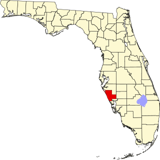
This is a list of the National Register of Historic Places listings in Sarasota County, Florida.

<span class="mw-page-title-main">National Register of Historic Places listings in Lake County, Florida</span>

This is a list of the National Register of Historic Places listings in Lake County, Florida.

<span class="mw-page-title-main">National Register of Historic Places listings in Doniphan County, Kansas</span>

This is a list of the National Register of Historic Places listings in Doniphan County, Kansas.

<span class="mw-page-title-main">National Register of Historic Places listings in Oxford County, Maine</span>

This is a list of the National Register of Historic Places listings in Oxford County, Maine.

<span class="mw-page-title-main">National Register of Historic Places listings in Pulaski County, Arkansas</span>

This is a list of the National Register of Historic Places listings in Pulaski County, Arkansas.

<span class="mw-page-title-main">National Register of Historic Places listings in Clark County, Arkansas</span>

This is a list of the National Register of Historic Places listings in Clark County, Arkansas.

<span class="mw-page-title-main">National Register of Historic Places listings in Arkansas County, Arkansas</span>

This is a list of the National Register of Historic Places listings in Arkansas County, Arkansas.

<span class="mw-page-title-main">National Register of Historic Places listings in Drew County, Arkansas</span>

This is a list of the National Register of Historic Places listings in Drew County, Arkansas.

<span class="mw-page-title-main">National Register of Historic Places listings in Faulkner County, Arkansas</span>

This is a list of the National Register of Historic Places listings in Faulkner County, Arkansas.

<span class="mw-page-title-main">National Register of Historic Places listings in Crittenden County, Arkansas</span>

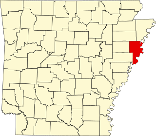
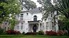
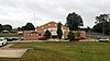
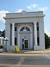
This is a list of the National Register of Historic Places listings in Crittenden County, Arkansas.

<span class="mw-page-title-main">National Register of Historic Places listings in Lee County, Arkansas</span>

This is a list of the National Register of Historic Places listings in Lee County, Arkansas.

<span class="mw-page-title-main">National Register of Historic Places listings in Little River County, Arkansas</span>

This is a list of the National Register of Historic Places listings in Little River County, Arkansas.

<span class="mw-page-title-main">National Register of Historic Places listings in Logan County, Arkansas</span>

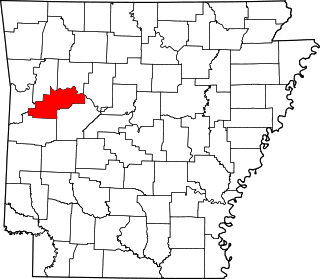
This is a list of the National Register of Historic Places listings in Logan County, Arkansas.

<span class="mw-page-title-main">National Register of Historic Places listings in Lawrence County, Arkansas</span>

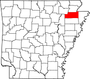
This is a list of the National Register of Historic Places listings in Lawrence County, Arkansas.

<span class="mw-page-title-main">National Register of Historic Places listings in Ouachita County, Arkansas</span>

This is a list of the National Register of Historic Places listings in Ouachita County, Arkansas.

<span class="mw-page-title-main">National Register of Historic Places listings in Polk County, Arkansas</span>

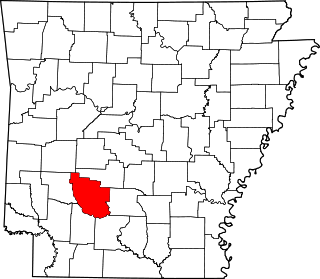
This is a list of the National Register of Historic Places listings in Polk County, Arkansas.

<span class="mw-page-title-main">National Register of Historic Places listings in Pope County, Arkansas</span>

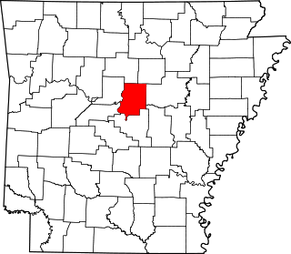
This is a list of the National Register of Historic Places listings in Pope County, Arkansas.

<span class="mw-page-title-main">National Register of Historic Places listings in Van Buren County, Arkansas</span>

This is a list of the National Register of Historic Places listings in Van Buren County, Arkansas.

<span class="mw-page-title-main">National Register of Historic Places listings in White County, Arkansas</span>

This is a list of the National Register of Historic Places listings in White County, Arkansas.

<span class="mw-page-title-main">National Register of Historic Places listings in Little Rock, Arkansas</span>

This is a list of the National Register of Historic Places listings in Little Rock, Arkansas.

References

  1. The latitude and longitude information provided in this table was derived originally from the National Register Information System, which has been found to be fairly accurate for about 99% of listings. Some locations in this table may have been corrected to current GPS standards.
  2. National Park Service, United States Department of the Interior, "National Register of Historic Places: Weekly List Actions", retrieved May 24, 2024.
  3. 1 2 Numbers represent an alphabetical ordering by significant words. Various colorings, defined here, differentiate National Historic Landmarks and historic districts from other NRHP buildings, structures, sites or objects.
  4. "National Register Information System". National Register of Historic Places . National Park Service. March 13, 2009.
  5. The eight-digit number below each date is the number assigned to each location in the National Register Information System database, which can be viewed by clicking the number.