National Register of Historic Places listings in Graves County, Kentucky

Last updated

Location of Graves County in Kentucky Map of Kentucky highlighting Graves County.svg
Location of Graves County in Kentucky

This is a list of the National Register of Historic Places listings in Graves County, Kentucky.

Contents

It is intended to be a complete list of the properties and districts on the National Register of Historic Places in Graves County, Kentucky, United States. The locations of National Register properties and districts for which the latitude and longitude coordinates are included below, may be seen in a map. [1]

There are 11 properties and districts listed on the National Register in the county.


    This National Park Service list is complete through NPS recent listings posted March 4, 2022. [2]

Map all coordinates using: OpenStreetMap  
Download coordinates as: KML

Current listings

[3] Name on the RegisterImageDate listed [4] Location City or townDescription
1 Camp Beauregard Memorial in Water Valley
Camp Beauregard Memorial in Water Valley Camp Beauregard Memorial monument.JPG
Camp Beauregard Memorial in Water Valley
July 17, 1997
(#97000698)
Camp Beauregard Cemetery, 0.5 miles south of the junction of Roy Lawrence and Cuba Rds.
36°34′22″N88°47′36″W / 36.572778°N 88.793333°W / 36.572778; -88.793333 (Camp Beauregard Memorial in Water Valley)
Water Valley
2 Confederate Memorial Gates in Mayfield
Confederate Memorial Gates in Mayfield Confederate Memorial Gates in Mayfield.JPG
Confederate Memorial Gates in Mayfield
July 17, 1997
(#97000696)
Maplewood Cemetery, 1 block south of the junction of Kentucky Routes 80 and 121
36°44′56″N88°38′04″W / 36.748806°N 88.634444°W / 36.748806; -88.634444 (Confederate Memorial Gates in Mayfield)
Mayfield
3 Confederate Memorial in Mayfield
Confederate Memorial in Mayfield Confederate Memorial in Mayfield.JPG
Confederate Memorial in Mayfield
July 17, 1997
(#97000697)
2 blocks north of the junction of 5th and Lee Sts.
36°44′29″N88°38′07″W / 36.741389°N 88.635194°W / 36.741389; -88.635194 (Confederate Memorial in Mayfield)
Mayfield
4 Pete Lyles House
Pete Lyles House Pete Lyles 4.png
Pete Lyles House
December 26, 2006
(#06001202)
302 Kentucky Route 348, E.
36°55′07″N88°30′54″W / 36.918611°N 88.515°W / 36.918611; -88.515 (Pete Lyles House)
Symsonia
5 Mayfield Downtown Commercial District
Mayfield Downtown Commercial District Graves County Courthouse KY.JPG
Mayfield Downtown Commercial District
August 16, 1984
(#84001477)
Roughly bounded by North, Water, 5th, and 9th Sts.; also roughly bounded by N. 9th, W. and E. North, N. and S. 5th, E. Water, and S. and N. 8th Sts.
36°44′28″N88°38′09″W / 36.741111°N 88.635833°W / 36.741111; -88.635833 (Mayfield Downtown Commercial District)
Mayfield Second set of streets represents a boundary increase
6 Mayfield Electric and Water Systems
Mayfield Electric and Water Systems Mayfield Electric and Water Systems.jpg
Mayfield Electric and Water Systems
August 18, 2011
(#11000536)
301 E. Broadway
36°44′31″N88°38′03″W / 36.741944°N 88.634167°W / 36.741944; -88.634167 (Mayfield Electric and Water Systems)
Mayfield
7 Meacham Manor December 31, 1974
(#74000877)
7 miles east of Fulton off Kentucky Route 116
36°30′20″N88°43′33″W / 36.505556°N 88.725833°W / 36.505556; -88.725833 (Meacham Manor)
Fulton
8 St. Jerome's Catholic Church Complex
St. Jerome's Catholic Church Complex St. Jerome's Catholic Church Fancy Farm Kentucky 8-2-2014.JPG
St. Jerome's Catholic Church Complex
January 8, 2014
(#13001052)
20 Kentucky Route 339 and 10225 Kentucky Route 80 W.
36°47′58″N88°47′27″W / 36.799444°N 88.790833°W / 36.799444; -88.790833 (St. Jerome's Catholic Church Complex)
Fancy Farm
9 U.S. Post Office
U.S. Post Office Mayfield post office.jpg
U.S. Post Office
December 2, 1982
(#82001566)
9th St. and Broadway
36°44′31″N88°38′18″W / 36.741833°N 88.638333°W / 36.741833; -88.638333 (U.S. Post Office)
Mayfield
10 Wooldridge Monuments
Wooldridge Monuments Wooldridge Monuments.JPG
Wooldridge Monuments
August 11, 1980
(#80001533)
Maplewood Cemetery
36°44′58″N88°38′12″W / 36.749444°N 88.636528°W / 36.749444; -88.636528 (Wooldridge Monuments)
Mayfield
11 Youngblood Site (15GV26) April 4, 1986
(#86000694)
Address Restricted
Hicksville

See also

Related Research Articles

National Register of Historic Places listings in Shelby County, Kentucky

This is a list of the National Register of Historic Places listings in Shelby County, Kentucky.

National Register of Historic Places listings in Grayson County, Kentucky Wikimedia list article

This is a list of the National Register of Historic Places listings in Grayson County, Kentucky.

National Register of Historic Places listings in Boyle County, Kentucky

This is a list of the National Register of Historic Places listings in Boyle County, Kentucky.

National Register of Historic Places listings in Daviess County, Kentucky

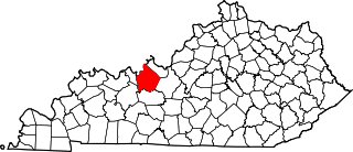
This is a list of the National Register of Historic Places listings in Daviess County, Kentucky.

National Register of Historic Places listings in Barren County, Kentucky

This is a list of the National Register of Historic Places listings in Barren County, Kentucky.

National Register of Historic Places listings in Christian County, Kentucky

This is a list of the National Register of Historic Places listings in Christian County, Kentucky.

National Register of Historic Places listings in Clark County, Kentucky

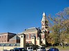
This is a list of the National Register of Historic Places listings in Clark County, Kentucky.

National Register of Historic Places listings in Carroll County, Kentucky

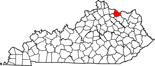
This is a list of the National Register of Historic Places listings in Carroll County, Kentucky.

National Register of Historic Places listings in Breckinridge County, Kentucky

This is a list of the National Register of Historic Places listings in Breckinridge County, Kentucky.

National Register of Historic Places listings in Spencer County, Kentucky

This is a list of the National Register of Historic Places listings in Spencer County, Kentucky.

National Register of Historic Places listings in Simpson County, Kentucky

This is a list of the National Register of Historic Places listings in Simpson County, Kentucky.

National Register of Historic Places listings in Mason County, Kentucky

This is a list of the National Register of Historic Places listings in Mason County, Kentucky.

National Register of Historic Places listings in Meade County, Kentucky

This is a list of the National Register of Historic Places listings in Meade County, Kentucky.

National Register of Historic Places listings in Madison County, Kentucky

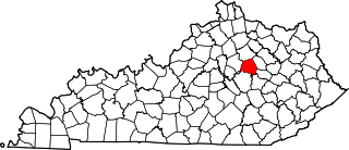
This is a list of the National Register of Historic Places listings in Madison County, Kentucky.

National Register of Historic Places listings in Owen County, Kentucky

This is a list of the National Register of Historic Places listings in Owen County, Kentucky.

National Register of Historic Places listings in Henry County, Kentucky

This is a list of the National Register of Historic Places listings in Henry County, Kentucky.

National Register of Historic Places listings in Hancock County, Kentucky

This is a list of the National Register of Historic Places listings in Hancock County, Kentucky.

National Register of Historic Places listings in Lawrence County, Kentucky

This is a list of the National Register of Historic Places listings in Lawrence County, Kentucky.

National Register of Historic Places listings in Clay County, Kentucky

This is a list of the National Register of Historic Places listings in Clay County, Kentucky.

National Register of Historic Places listings in Harlan County, Kentucky

This is a list of the National Register of Historic Places listings in Harlan County, Kentucky.

References

  1. The latitude and longitude information provided in this table was derived originally from the National Register Information System, which has been found to be fairly accurate for about 99% of listings. Some locations in this table may have been corrected to current GPS standards.
  2. National Park Service, United States Department of the Interior, "National Register of Historic Places: Weekly List Actions", retrieved March 4, 2022.
  3. Numbers represent an alphabetical ordering by significant words. Various colorings, defined here, differentiate National Historic Landmarks and historic districts from other NRHP buildings, structures, sites or objects.
  4. The eight-digit number below each date is the number assigned to each location in the National Register Information System database, which can be viewed by clicking the number.