National Register of Historic Places listings in Todd County, Kentucky

Last updated
Location of Todd County in Kentucky Map of Kentucky highlighting Todd County.svg
Location of Todd County in Kentucky

This is a list of the National Register of Historic Places listings in Todd County, Kentucky.

Contents

This is intended to be a complete list of the properties and districts on the National Register of Historic Places in Todd County, Kentucky, United States. The locations of National Register properties and districts for which the latitude and longitude coordinates are included below, may be seen in a map. [1]

There are 15 properties and districts listed on the National Register in the county.

This National Park Service list is complete through NPS recent listings posted April 16, 2021. [2]
Map all coordinates using: OpenStreetMap  
Download coordinates as: KML

Current listings

[3] Name on the RegisterImageDate listed [4] Location City or townDescription
1 Allensville Historic District
Allensville Historic District Allensville-Haddox-House-ky.jpg
Allensville Historic District
November 14, 1988
(#88002611)
Kentucky Route 102/Main St.
36°42′58″N87°04′06″W / 36.716111°N 87.068333°W / 36.716111; -87.068333 (Allensville Historic District)
Allensville
2 Bethel Baptist Church
Bethel Baptist Church Bethel Baptist Church in Fairview.jpg
Bethel Baptist Church
November 17, 1977
(#77000651)
U.S. Route 68
36°50′37″N87°17′55″W / 36.843611°N 87.298611°W / 36.843611; -87.298611 (Bethel Baptist Church)
Fairview
3 Jefferson Davis Monument
Jefferson Davis Monument Jeff Davis KY monument north.JPG
Jefferson Davis Monument
May 9, 1973
(#73000849)
On Kentucky Route 115 near its junction with U.S. Route 68
36°50′31″N87°18′02″W / 36.841944°N 87.300556°W / 36.841944; -87.300556 (Jefferson Davis Monument)
Fairview
4 Edwards Hall
Edwards Hall Edwards Hall in Elkton.jpg
Edwards Hall
January 11, 1974
(#74000906)
Southern side of Goebel Ave.
36°48′14″N87°09′07″W / 36.803889°N 87.151944°W / 36.803889; -87.151944 (Edwards Hall)
Elkton
5 Elkton Commercial Historic District
Elkton Commercial Historic District Northern side of square in Elkton.jpg
Elkton Commercial Historic District
November 13, 1989
(#89001976)
Junction of N., S., E., and W. Main Sts.
36°48′34″N87°09′15″W / 36.809444°N 87.154167°W / 36.809444; -87.154167 (Elkton Commercial Historic District)
Elkton
6 Gray's Inn
Gray's Inn STAGE-COACH-INN-3.jpg
Gray's Inn
November 26, 2004
(#04001254)
88 Graysville Rd.
36°38′46″N87°11′57″W / 36.646111°N 87.199167°W / 36.646111; -87.199167 (Gray's Inn)
Guthrie
7 John Gray Springhouse January 8, 1987
(#87000146)
U.S. Route 68
36°48′42″N87°09′32″W / 36.811667°N 87.158889°W / 36.811667; -87.158889 (John Gray Springhouse)
Elkton
8 Guthrie Historic District
Guthrie Historic District Guthrie Historic District.jpg
Guthrie Historic District
November 10, 2011
(#11000801)
Roughly bounded by Ewing, Park & Cherry Sts.
36°38′54″N87°09′59″W / 36.648378°N 87.166392°W / 36.648378; -87.166392 (Guthrie Historic District)
Guthrie
9 Hadden Site (15TO1) December 19, 1985
(#85003218)
Address Restricted
Elkton
10 Idlewild April 10, 1980
(#80001670)
Southeast of Trenton on U.S. Route 41
36°41′14″N87°13′52″W / 36.687222°N 87.231111°W / 36.687222; -87.231111 (Idlewild)
Trenton
11 McReynolds House
McReynolds House McReynolds House in Elkton.jpg
McReynolds House
October 22, 1976
(#76000946)
S. Main St.
36°48′25″N87°09′18″W / 36.806944°N 87.155°W / 36.806944; -87.155 (McReynolds House)
Elkton
12 Milliken Memorial Community House
Milliken Memorial Community House Milliken Memorial Community House, Elkton, Kentucky.jpg
Milliken Memorial Community House
December 6, 1990
(#90001834)
208 W. Main St.
36°48′37″N87°09′21″W / 36.810278°N 87.155833°W / 36.810278; -87.155833 (Milliken Memorial Community House)
Elkton
13 W.L. Reeves House
W.L. Reeves House W.L. Reeves House.jpg
W.L. Reeves House
February 2, 1984
(#84002024)
Kentucky Route 102
36°48′12″N87°08′54″W / 36.803333°N 87.148333°W / 36.803333; -87.148333 (W.L. Reeves House)
Elkton
14 Todd County Courthouse
Todd County Courthouse Todd County KY Courthouse.png
Todd County Courthouse
August 22, 1975
(#75000836)
Public Sq.
36°48′34″N87°09′15″W / 36.809444°N 87.154167°W / 36.809444; -87.154167 (Todd County Courthouse)
Elkton
15 Woodstock
Woodstock Woodstock-KY.jpg
Woodstock
November 10, 2010
(#10000904)
6338 Clarksville Rd.
36°38′40″N87°18′44″W / 36.644444°N 87.312222°W / 36.644444; -87.312222 (Woodstock)
Trenton

See also

Related Research Articles

National Register of Historic Places listings in Woodford County, Kentucky

This is a list of the National Register of Historic Places listings in Woodford County, Kentucky.

National Register of Historic Places listings in Shelby County, Kentucky

This is a list of the National Register of Historic Places listings in Shelby County, Kentucky.

National Register of Historic Places listings in Franklin County, Kentucky Wikipedia list article

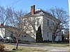
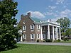
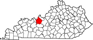
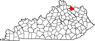
This is a list of the National Register of Historic Places listings in Franklin County, Kentucky.

National Register of Historic Places listings in Hardin County, Kentucky

This is a list of the National Register of Historic Places listings in Hardin County, Kentucky.

National Register of Historic Places listings in Boyle County, Kentucky

This is a list of the National Register of Historic Places listings in Boyle County, Kentucky.

National Register of Historic Places listings in Daviess County, Kentucky

This is a list of the National Register of Historic Places listings in Daviess County, Kentucky.

National Register of Historic Places listings in Barren County, Kentucky

This is a list of the National Register of Historic Places listings in Barren County, Kentucky.

National Register of Historic Places listings in Christian County, Kentucky

This is a list of the National Register of Historic Places listings in Christian County, Kentucky.

National Register of Historic Places listings in Breckinridge County, Kentucky

This is a list of the National Register of Historic Places listings in Breckinridge County, Kentucky.

National Register of Historic Places listings in Spencer County, Kentucky

This is a list of the National Register of Historic Places listings in Spencer County, Kentucky.

National Register of Historic Places listings in Powell County, Kentucky

This is a list of the National Register of Historic Places listings in Powell County, Kentucky.

National Register of Historic Places listings in Pulaski County, Kentucky

This is a list of the National Register of Historic Places listings in Pulaski County, Kentucky.

National Register of Historic Places listings in Mason County, Kentucky

This is a list of the National Register of Historic Places listings in Mason County, Kentucky.

National Register of Historic Places listings in Madison County, Kentucky

This is a list of the National Register of Historic Places listings in Madison County, Kentucky.

National Register of Historic Places listings in Muhlenberg County, Kentucky

This is a list of the National Register of Historic Places listings in Muhlenberg County, Kentucky.

National Register of Historic Places listings in Mercer County, Kentucky

This is a list of the National Register of Historic Places listings in Mercer County, Kentucky.

National Register of Historic Places listings in Floyd County, Kentucky

This is a list of the National Register of Historic Places listings in Floyd County, Kentucky.

National Register of Historic Places listings in Hancock County, Kentucky

This is a list of the National Register of Historic Places listings in Hancock County, Kentucky.

National Register of Historic Places listings in Lawrence County, Kentucky

This is a list of the National Register of Historic Places listings in Lawrence County, Kentucky.

National Register of Historic Places listings in Johnson County, Kentucky

This is a list of the National Register of Historic Places listings in Johnson County, Kentucky.

References

  1. The latitude and longitude information provided in this table was derived originally from the National Register Information System, which has been found to be fairly accurate for about 99% of listings. Some locations in this table may have been corrected to current GPS standards.
  2. National Park Service, United States Department of the Interior, "National Register of Historic Places: Weekly List Actions", retrieved April 16, 2021.
  3. Numbers represent an alphabetical ordering by significant words. Various colorings, defined here, differentiate National Historic Landmarks and historic districts from other NRHP buildings, structures, sites or objects.
  4. The eight-digit number below each date is the number assigned to each location in the National Register Information System database, which can be viewed by clicking the number.