National Register of Historic Places listings in McLean County, Kentucky

Last updated
Location of McLean County in Kentucky Map of Kentucky highlighting McLean County.svg
Location of McLean County in Kentucky

This is a list of the National Register of Historic Places listings in McLean County, Kentucky.

Contents

It is intended to be a complete list of the properties on the National Register of Historic Places in McLean County, Kentucky, United States. The locations of National Register properties for which the latitude and longitude coordinates are included below, may be seen in a map. [1]

There are 9 properties listed on the National Register in the county, of which 6 are part of a National Historic Landmark spread across multiple counties.

This National Park Service list is complete through NPS recent listings posted December 4, 2020. [2]
Map all coordinates using: OpenStreetMap  
Download coordinates as: KML  ·  GPX

Current listings

[3] Name on the RegisterImageDate listed [4] Location City or townDescription
1 Archaeological Site 15 McL 18
Archaeological Site 15 McL 18 Archeological Site 15McL18.jpg
Archaeological Site 15 McL 18
March 15, 1982
(#82002738)
Left bank of the Green River, 1.5 miles (2.4 km) below the mouth of the Rough River [5] :4
37°29′08″N87°09′52″W / 37.485556°N 87.164444°W / 37.485556; -87.164444 (Archaeological Site 15 McL 18)
Livermore
2 Archeological Site No. 15McL16
Archeological Site No. 15McL16 Archeological Site 15McL16.jpg
Archeological Site No. 15McL16
April 1, 1986
(#86000648)
Left bank of the Green River immediately above Rumsey [5] :4
37°31′48″N87°15′05″W / 37.530000°N 87.251389°W / 37.530000; -87.251389 (Archeological Site No. 15McL16)
Rumsey Part of the Green River Shell Middens Archeological District National Historic Landmark [6] :21
3 Archeological Site No. 15McL17 April 1, 1986
(#86000649)
Above the right bank of the Rough River, 1.5 miles (2.4 km) east of Livermore [5] :4
37°29′03″N87°06′21″W / 37.484167°N 87.105833°W / 37.484167; -87.105833 (Archeological Site No. 15McL17)
Livermore Part of the Green River Shell Middens Archeological District National Historic Landmark [6] :22
4 Austin Site (15McL15)
Austin Site (15McL15) Austin Site from KY138.jpg
Austin Site (15McL15)
April 1, 1986
(#86000650)
Left bank of the Green River, 4 miles (6.4 km) below Calhoun [5] :4
37°32′36″N87°18′21″W / 37.543333°N 87.305833°W / 37.543333; -87.305833 (Austin Site (15McL15))
Calhoun Part of the Green River Shell Middens Archeological District National Historic Landmark [6] :20
5 Battle of Sacramento Battlefield
Battle of Sacramento Battlefield Battlefield at Sacramento.jpg
Battle of Sacramento Battlefield
March 24, 1998
(#97000875)
Junction of Kentucky Routes 81 and 85
37°25′10″N87°15′42″W / 37.419444°N 87.261667°W / 37.419444; -87.261667 (Battle of Sacramento Battlefield)
Sacramento
6 Butterfield Site (15McL7)
Butterfield Site (15McL7) Butterfield Site at Livermore.jpg
Butterfield Site (15McL7)
April 1, 1986
(#86000651)
Southern bank of the Green River across from the mouth of the Rough River [5] :31
37°28′57″N87°08′03″W / 37.482500°N 87.134167°W / 37.482500; -87.134167 (Butterfield Site (15McL7))
Livermore Part of the Green River Shell Middens Archeological District National Historic Landmark [6] :19
7 Crowe Shell Midden (15McL109)
Crowe Shell Midden (15McL109) Crowe Shell Midden from southeast.jpg
Crowe Shell Midden (15McL109)
April 1, 1986
(#86000652)
Left bank of the Green River, 1 mile (1.6 km) above Livermore [7]
37°28′26″N87°07′27″W / 37.473889°N 87.124167°W / 37.473889; -87.124167 (Crowe Shell Midden (15McL109))
KirtleyPart of the Green River Shell Middens Archeological District National Historic Landmark [6] :23
8 R.D. Ford Shell Midden (15McL2) April 1, 1986
(#86000653)
Along the Green River off Kentucky Route 256, west of Calhoun [5] :4
37°33′36″N87°22′00″W / 37.560000°N 87.366667°W / 37.560000; -87.366667 (R.D. Ford Shell Midden (15McL2))
Ashbyburg Part of the Green River Shell Middens Archeological District National Historic Landmark. [6] :18
9 Griffith-Franklin House
Griffith-Franklin House Griffith-Franklin House in Calhoun.jpg
Griffith-Franklin House
July 7, 1975
(#75002061)
207 W. 2nd St.
37°32′13″N87°15′38″W / 37.536944°N 87.260556°W / 37.536944; -87.260556 (Griffith-Franklin House)
Calhoun

See also

Related Research Articles

National Register of Historic Places listings in Woodford County, Kentucky

This is a list of the National Register of Historic Places listings in Woodford County, Kentucky.

National Register of Historic Places listings in Shelby County, Kentucky

This is a list of the National Register of Historic Places listings in Shelby County, Kentucky.

National Register of Historic Places listings in Henderson County, Kentucky

This is a list of the National Register of Historic Places listings in Henderson County, Kentucky.

National Register of Historic Places listings in Hardin County, Kentucky

This is a list of the National Register of Historic Places listings in Hardin County, Kentucky.

National Register of Historic Places listings in Greenup County, Kentucky

This is a list of the National Register of Historic Places listings in Greenup County, Kentucky.

National Register of Historic Places listings in Green County, Kentucky

This is a list of the National Register of Historic Places listings in Green County, Kentucky.

National Register of Historic Places listings in Boyle County, Kentucky

This is a list of the National Register of Historic Places listings in Boyle County, Kentucky.

National Register of Historic Places listings in Barren County, Kentucky

This is a list of the National Register of Historic Places listings in Barren County, Kentucky.

National Register of Historic Places listings in Butler County, Kentucky

This is a list of the National Register of Historic Places listings in Butler County, Kentucky.

National Register of Historic Places listings in Mason County, Kentucky

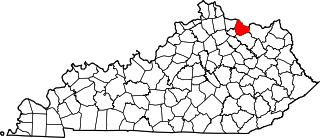
This is a list of the National Register of Historic Places listings in Mason County, Kentucky.

National Register of Historic Places listings in Madison County, Kentucky

This is a list of the National Register of Historic Places listings in Madison County, Kentucky.

National Register of Historic Places listings in Muhlenberg County, Kentucky

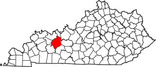
This is a list of the National Register of Historic Places listings in Muhlenberg County, Kentucky.

National Register of Historic Places listings in Mercer County, Kentucky

This is a list of the National Register of Historic Places listings in Mercer County, Kentucky.

National Register of Historic Places listings in Ohio County, Kentucky

This is a list of the National Register of Historic Places listings in Ohio County, Kentucky.

National Register of Historic Places listings in Floyd County, Kentucky

This is a list of the National Register of Historic Places listings in Floyd County, Kentucky.

National Register of Historic Places listings in Ballard County, Kentucky

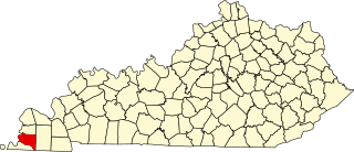
This is a list of the National Register of Historic Places listings in Ballard County, Kentucky.

National Register of Historic Places listings in Harlan County, Kentucky

This is a list of the National Register of Historic Places listings in Harlan County, Kentucky.

National Register of Historic Places listings in Hickman County, Kentucky

This is a list of the National Register of Historic Places listings in Hickman County, Kentucky.

National Register of Historic Places listings in Menifee County, Kentucky

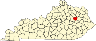
This is a list of the National Register of Historic Places listings in Menifee County, Kentucky.

National Register of Historic Places listings in Wayne County, Kentucky

This is a list of the National Register of Historic Places listings in Wayne County, Kentucky.

References

  1. The latitude and longitude information provided in this table was derived originally from the National Register Information System, which has been found to be fairly accurate for about 99% of listings. Some locations in this table may have been corrected to current GPS standards.
  2. "National Register of Historic Places: Weekly List Actions". National Park Service, United States Department of the Interior. Retrieved on December 4, 2020.
  3. Numbers represent an alphabetical ordering by significant words. Various colorings, defined here, differentiate National Historic Landmarks and historic districts from other NRHP buildings, structures, sites or objects.
  4. The eight-digit number below each date is the number assigned to each location in the National Register Information System database, which can be viewed by clicking the number.
  5. 1 2 3 4 5 6 Webb, William S., and William G. Haag. "Archaic Sites in McLean County, Kentucky". University of Kentucky Reports in Anthropology 7.1 (1947): 1-46.
  6. 1 2 3 4 5 6 National Historic Landmark Nomination: Green River Shell Middens. National Park Service: 1994-05-05.
  7. Claassen, Cheryl. Feasting with Shellfish in the Southern Ohio Valley: Archaic Sacred Sites and Rituals. Knoxville: U of Tennessee P, 2010, 41.