National Register of Historic Places listings in Logan County, Kentucky

Last updated
Location of Logan County in Kentucky Map of Kentucky highlighting Logan County.svg
Location of Logan County in Kentucky

This is a list of the National Register of Historic Places listings in Logan County, Kentucky.

Contents

This is intended to be a complete list of the properties and districts on the National Register of Historic Places in Logan County, Kentucky, United States. The locations of National Register properties and districts for which the latitude and longitude coordinates are included below, may be seen in a map. [1]

There are 22 properties and districts listed on the National Register in the county.

This National Park Service list is complete through NPS recent listings posted April 9, 2021. [2]
Map all coordinates using: OpenStreetMap  
Download coordinates as: KML

Current listings

[3] Name on the RegisterImageDate listed [4] Location City or townDescription
1 Auburn Historic District
Auburn Historic District Public square in Auburn.jpg
Auburn Historic District
March 28, 1994
(#94000222)
Roughly along E. and W. Main, N. Lincoln, Perkins, Pearl, Caldwell, Wilson, Maple, and Viers Sts.
36°51′50″N86°42′46″W / 36.863889°N 86.712778°W / 36.863889; -86.712778 (Auburn Historic District)
Auburn
2 Black Bottom Historic District
Black Bottom Historic District Sixth east of Morgan in the Black Bottom.jpg
Black Bottom Historic District
March 17, 2010
(#09000007)
Bounded by E. 5th and 7th Sts., Bowling Green Rd. and Morgan St.
36°50′42″N86°52′51″W / 36.845000°N 86.880833°W / 36.845000; -86.880833 (Black Bottom Historic District)
Russellville
3 Brodnax-Conn House
Brodnax-Conn House Broadnax-Conn House.jpg
Brodnax-Conn House
October 23, 1992
(#92001339)
3288 Conn Rd.
36°41′55″N86°46′29″W / 36.698611°N 86.774722°W / 36.698611; -86.774722 (Brodnax-Conn House)
Adairville
4 Cedar Grove Rosenwald School
Cedar Grove Rosenwald School Cedar Grove Rosenwald School.jpg
Cedar Grove Rosenwald School
April 11, 2002
(#02000342)
375 Cedar Grove Rd.
36°44′16″N86°58′26″W / 36.737778°N 86.973889°W / 36.737778; -86.973889 (Cedar Grove Rosenwald School)
Olmstead
5 Confederate Monument in Russellville
Confederate Monument in Russellville CSA Memorial Russellville KY.png
Confederate Monument in Russellville
July 17, 1997
(#97000681)
Town Square at the junction of U.S. Routes 68 and 431
36°50′42″N86°53′15″W / 36.845°N 86.8875°W / 36.845; -86.8875 (Confederate Monument in Russellville)
Russellville
6 G.W. Davidson House and Bank
G.W. Davidson House and Bank G.W. Davidson House.jpg
G.W. Davidson House and Bank
October 29, 1982
(#82001570)
Main St.
36°51′46″N86°42′38″W / 36.862778°N 86.710556°W / 36.862778; -86.710556 (G.W. Davidson House and Bank)
Auburn
7 William Forst House
William Forst House Clark House Russellville KY.png
William Forst House
July 19, 1973
(#73000816)
4th and Winter Sts.
36°50′42″N86°53′21″W / 36.845°N 86.889167°W / 36.845; -86.889167 (William Forst House)
Russellville
8 Long-Briggs House
Long-Briggs House Long-Briggs House.jpg
Long-Briggs House
November 27, 1978
(#78001379)
Cornelius Ave.
36°50′50″N86°53′37″W / 36.847222°N 86.893611°W / 36.847222; -86.893611 (Long-Briggs House)
Russellville
9 Longview Farm House
Longview Farm House Longview Farm House.jpg
Longview Farm House
March 19, 1992
(#92000170)
Bores Rd.
36°43′46″N86°49′55″W / 36.729444°N 86.831944°W / 36.729444; -86.831944 (Longview Farm House)
Adairville
10 McCutchen Meadows
McCutchen Meadows McCutcheon Meadows plantation house.jpg
McCutchen Meadows
November 23, 1984
(#84000292)
Off U.S. Route 68
36°52′25″N86°40′58″W / 36.873611°N 86.682778°W / 36.873611; -86.682778 (McCutchen Meadows)
Auburn
11 Rev. James McGready House April 21, 1976
(#76000918)
West of Russellville off U.S. Route 68
36°50′14″N86°54′52″W / 36.837222°N 86.914444°W / 36.837222; -86.914444 (Rev. James McGready House)
Russellville
12 Page Site (15LO1) November 14, 1985
(#85002819)
Above the Mud River off Lost City Road, east of Lewisburg [5]
36°58′34″N86°54′20″W / 36.976111°N 86.905556°W / 36.976111; -86.905556 (Page Site (15LO1))
Lewisburg Major Mississippian site, developed as a heritage tourism attraction, "Lost City", in the 1930s [5]
13 Pleasant Run Methodist Church
Pleasant Run Methodist Church PleasantRunMethodistChurchGrounds2.jpg
Pleasant Run Methodist Church
October 29, 1982
(#82001571)
Southeast of Russellville on Kentucky Route 663
36°46′00″N86°47′24″W / 36.766667°N 86.79°W / 36.766667; -86.79 (Pleasant Run Methodist Church)
Russellville
14 Red River Presbyterian Meetinghouse Site and Cemetery
Red River Presbyterian Meetinghouse Site and Cemetery Red River Meeting House.jpg
Red River Presbyterian Meetinghouse Site and Cemetery
June 18, 1976
(#76000917)
Northeast of Adairville off Kentucky Route 663
36°43′16″N86°48′53″W / 36.721111°N 86.814722°W / 36.721111; -86.814722 (Red River Presbyterian Meetinghouse Site and Cemetery)
Adairville
15 Rhea Stadium
Rhea Stadium Rhea Stadium wall.jpg
Rhea Stadium
July 8, 2008
(#08000647)
Northeastern corner of the intersection of E. 9th St. and S. Summer St.
36°50′30″N86°52′59″W / 36.841667°N 86.883056°W / 36.841667; -86.883056 (Rhea Stadium)
Russellville
16 Russellville Armory
Russellville Armory Russellville Armory.jpg
Russellville Armory
March 24, 2000
(#00000279)
190 S. Winter St.
36°50′40″N86°53′21″W / 36.844444°N 86.889167°W / 36.844444; -86.889167 (Russellville Armory)
Russellville
17 Russellville Historic District
Russellville Historic District Logan County courthouse Kentucky.JPG
Russellville Historic District
July 14, 1976
(#76000919)
Roughly bounded by 2nd, 9th, Caldwell, and Nashville Sts.
36°50′40″N86°53′08″W / 36.844444°N 86.885556°W / 36.844444; -86.885556 (Russellville Historic District)
Russellville
18 Savage Cave Archeological Site April 3, 1970
(#70000252)
Along the Red River, 1.75 km east of Adairville and 1.7 km north of the state line [6]
36°39′16″N86°50′09″W / 36.654444°N 86.835833°W / 36.654444; -86.835833 (Savage Cave Archeological Site)
Adairville
19 David Sawyer House
David Sawyer House David Sawyer House.jpg
David Sawyer House
January 8, 1987
(#87000214)
Off Kentucky Route 103
36°56′28″N86°46′50″W / 36.941111°N 86.780556°W / 36.941111; -86.780556 (David Sawyer House)
Chandlers Chapel
20 South Union Shaker Center House and Preservatory
South Union Shaker Center House and Preservatory South Union Shaker Center Dwelling House.jpg
South Union Shaker Center House and Preservatory
June 28, 1974
(#74000891)
U.S. Route 68
36°53′04″N86°38′42″W / 36.884444°N 86.645°W / 36.884444; -86.645 (South Union Shaker Center House and Preservatory)
South Union
21 South Union Shakertown Historic District
South Union Shakertown Historic District Shaker Centre Family Washhouse.jpg
South Union Shakertown Historic District
April 3, 1975
(#75000796)
Kentucky Route 73 at the Louisville and Nashville Railroad tracks, and by the junction of U.S. Route 68
36°53′05″N86°38′40″W / 36.884722°N 86.644444°W / 36.884722; -86.644444 (South Union Shakertown Historic District)
South Union
22 Watkins Site (15LO12)
Watkins Site (15LO12) Watkins Site from US68.jpg
Watkins Site (15LO12)
December 5, 1985
(#85003065)
Western side of Clear Fork Creek, 3 km above its confluence with the Gasper River [7]
36°53′52″N86°39′11″W / 36.897778°N 86.653056°W / 36.897778; -86.653056 (Watkins Site (15LO12))
South Union

See also

Related Research Articles

National Register of Historic Places listings in Jefferson County, Kentucky

The table below includes sites listed on the National Register of Historic Places (NRHP) in Jefferson County, Kentucky except those in the following neighborhoods/districts of Louisville: Anchorage, Downtown, The Highlands, Old Louisville, Portland and the West End. Links to tables of listings in these other areas are provided below.

National Register of Historic Places listings in Volusia County, Florida

This is a list of the National Register of Historic Places listings in Volusia County, Florida.

National Register of Historic Places listings in Daviess County, Kentucky

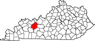
This is a list of the National Register of Historic Places listings in Daviess County, Kentucky.

National Register of Historic Places listings in Bracken County, Kentucky

This is a list of the National Register of Historic Places listings in Bracken County, Kentucky.

National Register of Historic Places listings in Boyd County, Kentucky

This is a list of the National Register of Historic Places listings in Boyd County, Kentucky.

National Register of Historic Places listings in Butler County, Kentucky

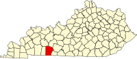
This is a list of the National Register of Historic Places listings in Butler County, Kentucky.

National Register of Historic Places listings in Calloway County, Kentucky

This is a list of the National Register of Historic Places listings in Calloway County, Kentucky. It is intended to be a complete list of the properties and districts on the National Register of Historic Places in Calloway County, Kentucky, United States. The locations of National Register properties and districts for which the latitude and longitude coordinates are included below, may be seen in a map.

National Register of Historic Places listings in Whitley County, Kentucky

This is a list of the National Register of Historic Places listings in Whitley County, Kentucky.

National Register of Historic Places listings in Powell County, Kentucky

This is a list of the National Register of Historic Places listings in Powell County, Kentucky.

National Register of Historic Places listings in Montgomery County, Kentucky

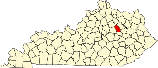
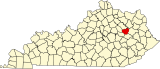
This is a list of the National Register of Historic Places listings in Montgomery County, Kentucky.

National Register of Historic Places listings in Mercer County, Kentucky

This is a list of the National Register of Historic Places listings in Mercer County, Kentucky.

National Register of Historic Places listings in Nelson County, Kentucky

This is a list of the National Register of Historic Places listings in Nelson County, Kentucky.

National Register of Historic Places listings in Ohio County, Kentucky

This is a list of the National Register of Historic Places listings in Ohio County, Kentucky.

National Register of Historic Places listings in Fulton County, Kentucky

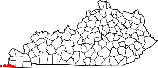
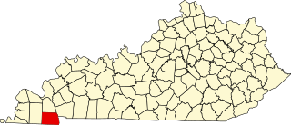
This is a list of the National Register of Historic Places listings in Fulton County, Kentucky.

National Register of Historic Places listings in Logan County, Ohio

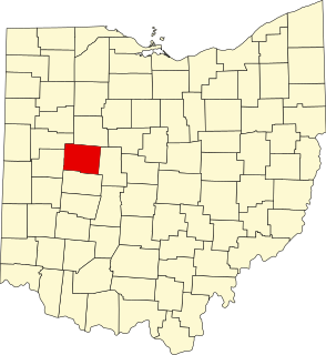
This is a list of the National Register of Historic Places listings in Logan County, Ohio.

National Register of Historic Places listings in Bullitt County, Kentucky

This is a list of the National Register of Historic Places listings in Bullitt County, Kentucky.

National Register of Historic Places listings in Ballard County, Kentucky

This is a list of the National Register of Historic Places listings in Ballard County, Kentucky.

National Register of Historic Places listings in Bath County, Kentucky

This is a list of the National Register of Historic Places listings in Bath County, Kentucky.

National Register of Historic Places listings in Marshall County, Kentucky

This is a list of the National Register of Historic Places listings in Marshall County, Kentucky.

National Register of Historic Places listings in Menifee County, Kentucky

This is a list of the National Register of Historic Places listings in Menifee County, Kentucky.

References

  1. The latitude and longitude information provided in this table was derived originally from the National Register Information System, which has been found to be fairly accurate for about 99% of listings. Some locations in this table may have been corrected to current GPS standards.
  2. National Park Service, United States Department of the Interior, "National Register of Historic Places: Weekly List Actions", retrieved April 9, 2021.
  3. Numbers represent an alphabetical ordering by significant words. Various colorings, defined here, differentiate National Historic Landmarks and historic districts from other NRHP buildings, structures, sites or objects.
  4. The eight-digit number below each date is the number assigned to each location in the National Register Information System database, which can be viewed by clicking the number.
  5. 1 2 "Protecting a Mound Complex". American Archaeological 7.3 (2003): 46.
  6. Parish, Ryan. "The Case for a Paleoindian Component at the Savage Cave Site (15Lo11)". Murray State University, n.d., 1. Accessed 2014-01-11.
  7. Applegate, Darlene. "Evidence of Differential Mortuary Treatment from the Watkins Site (15Lo12), a Woodland-Mississippi Period Burial Mound in South-Central Kentucky". In Proceedings of the 21st Mid-South Archaeological Conference: Ethnicity in Archaeology. Panamerican Consultants Special Publication 2. Buchner, C.A., ed. Memphis: Panamerican Consultants, 2002: 33-45.