National Register of Historic Places listings in Green County, Wisconsin
Last updated
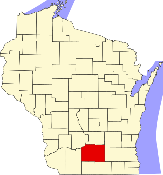
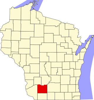
Location of Green County in Wisconsin
This is a list of the National Register of Historic Places listings in Green County, Wisconsin. It is intended to provide a comprehensive listing of entries in the National Register of Historic Places that are located in Green County, Wisconsin. The locations of National Register properties for which the latitude and longitude coordinates are included below may be seen in a map.[1]
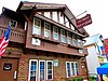
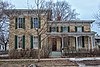
Formal Greek Revival house built in 1850 and expanded in 1877. Vermont-native Bingham came to Monroe in 1842 as a lawyer, became DA and judge, started banks, helped bring the railroad to Monroe, served on the school board, and was active in the Republican Party.[6][7]
1858 home in Greek Revival style. The walls are rubble limestone covered with a smooth plaster finish, a technique that New Glarus' settlers brought from Canton Glarus in Switzerland. Blumer was the village's first physician.[8][9]
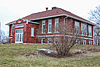
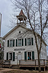
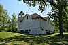
2-room State Graded school built in 1921, in Craftsman style with brick walls and a hip roof. Served the community until 1983 - then converted to a home.[10][11]
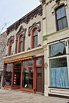
2-story store built in 1869 for Elisha Mosher's commission and auction business. Still has original cast iron columns at street level and elaborate brickwork above. Caradines bought it in 1907 to house their dental clinic.[12][13] Now a museum.[14]
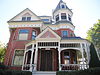
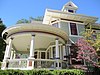
2.5 story elaborate Queen Anne-styled house with 3-story octagonal tower and matching coach house, built 1888-89. Frank was a merchant in Monroe.[16][17]
Blacksmith shop at a rural crossroad, built around 1873. Ten years later, Cleveland converted the second story to a dance hall and meeting room, while the first floor remained the smithy.
1929 gas station styled like an English cottage, with service bay. Pure Oil built hundreds of similar stations across the country, branding with architecture.
Historic farm started in 1848 by Swiss immigrant Fridolin Hefty and run by generations of the family. Includes 1859 granary, 1861 stone barn,[25] 1880 house,[26] 1881 cheese factory, 1882 frame dairy barn, and 1882 buggy shed.[27]
Smallish Second Empire-styled house built in 1878, brick-walled with bell-curved mansard roof. Chauncey Hulburt came west from New York in the 1840s and became a lumberman in Monroe, finishing the inside of this house with elegant woodwork.[28][29]
80-foot brick water tower built in 1889, originally with a 100,000 gallon wooden tank on top - now steel. The tower's water system was one of the first major public services provided by the city of Monroe.
Richardsonian Romanesque-styled school built in 1896, designed by Conover & Porter of Madison. Expanded in 1914, 1915 and 1933, with an Art Deco-styled gym added in 1939.[41][42]
Greek Revival-styled building built jointly in 1886 by the town and the Ancient Order of United Workmen. Town functions were on the first floor and basement, and the AOUW met upstairs.
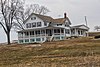
2.5-story Queen Anne-styled home with a large, round veranda. Regez was a Swiss immigrant who played an important role in developing Monroe's Swiss cheese industry.
2-story cream brick Italianate-styled house with delicate scroll-sawnbrackets built in 1877, with a 2-story brick carriage house. Francis was a New Yorker who arrived in Brodhead in 1865 and operated a grocery store near the house.[43][44]
Fine, intact 2-story Queen Anne-style home built in 1903-1904, with wood floors and original grills inside, and with a carriage barn. John was a partner in a general merchandise business, and involved in real estate, insurance, lumber and feed.[45][46]
A true round barn, built in 1922 with tile walls at ground level, wood walls above, and a silo in the middle. Albert was a professor of agriculture, as well as a farmer.[47]
This is a list of the National Register of Historic Places listings in Dane County, Wisconsin. It aims to provide a comprehensive listing of buildings, sites, structures, districts, and objects in Dane County, Wisconsin listed on the National Register of Historic Places.
This is a list of the National Register of Historic Places listings in Waukesha County, Wisconsin. It is intended to provide a comprehensive listing of entries in the National Register of Historic Places that are located in Waukesha County, Wisconsin. The locations of National Register properties for which the latitude and longitude coordinates are included below may be seen in a map.
This is a list of the National Register of Historic Places listings in Jefferson County, Wisconsin. It is intended to provide a comprehensive listing of entries in the National Register of Historic Places that are located in Jefferson County, Wisconsin. The locations of National Register properties for which the latitude and longitude coordinates are included below may be seen in a map.
This is a list of the National Register of Historic Places listings in Winnebago County, Wisconsin.
This is a list of the National Register of Historic Places listings in Fond du Lac County, Wisconsin. It is intended to provide a comprehensive listing of entries in the National Register of Historic Places that are located in Fond du Lac County, Wisconsin. The locations of National Register properties for which the latitude and longitude coordinates are included below may be seen in a map.
This is a list of the National Register of Historic Places listings in Grant County, Wisconsin. It is intended to provide a comprehensive listing of entries in the National Register of Historic Places that are located in Grant County, Wisconsin. The locations of National Register properties for which the latitude and longitude coordinates are included below may be seen in a map.
This is a list of the National Register of Historic Places listings in Iowa County, Wisconsin. It is intended to provide a comprehensive listing of entries in the National Register of Historic Places that are located in Iowa County, Wisconsin. The locations of National Register properties for which the latitude and longitude coordinates are included below may be seen in a map.
This is a list of the National Register of Historic Places listings in La Crosse County, Wisconsin. It is intended to provide a comprehensive listing of entries in the National Register of Historic Places that are located in La Crosse County, Wisconsin. The locations of National Register properties for which the latitude and longitude coordinates are included below may be seen in a map.
This is a list of the National Register of Historic Places listings in Ozaukee County, Wisconsin. It is intended to provide a comprehensive listing of entries in the National Register of Historic Places that are located in Ozaukee County, Wisconsin. The locations of National Register properties for which the latitude and longitude coordinates are included below may be seen in a map.
This is a list of the National Register of Historic Places listings in Racine County, Wisconsin. It is intended to provide a comprehensive listing of entries in the National Register of Historic Places that are located in Racine County, Wisconsin. The locations of National Register properties for which the latitude and longitude coordinates are included below may be seen in a map.
This is a list of the National Register of Historic Places listings in Sheboygan County, Wisconsin. It is intended to provide a comprehensive listing of entries in the National Register of Historic Places that are located in Sheboygan County, Wisconsin. The locations of National Register properties for which the latitude and longitude coordinates are included below may be seen in a map.
This is a list of the National Register of Historic Places listings in Walworth County, Wisconsin. It is intended to provide a comprehensive listing of entries in the National Register of Historic Places that are located in Walworth County, Wisconsin. The locations of National Register properties for which the latitude and longitude coordinates are included below may be seen in a map.
This is a list of the National Register of Historic Places listings in Washington County, Wisconsin. It is intended to provide a comprehensive listing of entries in the National Register of Historic Places that are located in Washington County, Wisconsin. The locations of National Register properties for which the latitude and longitude coordinates are included below may be seen in a map.
This is a list of the National Register of Historic Places listings in Manitowoc County, Wisconsin. It is intended to provide a comprehensive listing of entries in the National Register of Historic Places that are located in Manitowoc County, Wisconsin. The locations of National Register properties for which the latitude and longitude coordinates are included below may be seen in a map.
This is a list of the National Register of Historic Places listings in Lafayette County, Wisconsin. It is intended to provide a comprehensive listing of entries in the National Register of Historic Places that are located in Lafayette County, Wisconsin. The locations of National Register properties for which the latitude and longitude coordinates are included below may be seen in a map.
This is a list of the National Register of Historic Places listings in Portage County, Wisconsin. It is intended to provide a comprehensive listing of entries in the National Register of Historic Places that are located in Portage County, Wisconsin. The locations of National Register properties for which the latitude and longitude coordinates are included below may be seen in a map.
This is a list of the National Register of Historic Places listings in Chippewa County, Wisconsin. It is intended to provide a comprehensive listing of entries in the National Register of Historic Places that are located in Chippewa County, Wisconsin. The locations of National Register properties for which the latitude and longitude coordinates are included below may be seen in a map.
This list comprises buildings, sites, structures, districts, and objects in the City of Milwaukee, Wisconsin, which are listed on the National Register of Historic Places. There are 286 NRHP sites listed in Milwaukee County, including 72 outside the City of Milwaukee included in the National Register of Historic Places listings in Milwaukee County, Wisconsin and 214 in the city, listed below. One previously listed site in the city has been removed.
This is a list of the National Register of Historic Places listings in Wood County, Wisconsin. It is intended to provide a comprehensive listing of entries in the National Register of Historic Places that are located in Wood County, Wisconsin. The locations of National Register properties for which the latitude and longitude coordinates are included below may be seen in a map.
References
↑ The latitude and longitude information provided is primarily from the National Register Information System, and has been found to be fairly accurate for about 99% of listings. For 1%, the location info may be way off. We seek to correct the coordinate information wherever it is found to be erroneous. Please leave a note in the Discussion page for this article if you believe any specific location is incorrect.
↑ Numbers represent an alphabetical ordering by significant words. Various colorings, defined here, differentiate National Historic Landmarks and historic districts from other NRHP buildings, structures, sites or objects.
↑ The eight-digit number below each date is the number assigned to each location in the National Register Information System database, which can be viewed by clicking the number.
This page is based on this Wikipedia article Text is available under the CC BY-SA 4.0 license; additional terms may apply. Images, videos and audio are available under their respective licenses.