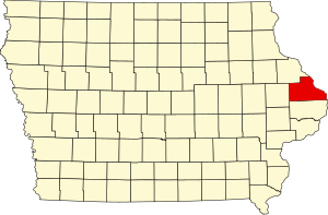
[3] Name on the Register [4] Image Date listed [5] Location City or town Description 1 D.H. Anderson Building Upload image April 10, 1986 (# 86000718 129 S. Main St. 42°04′06″N 90°39′54″W / 42.068333°N 90.665°W / 42.068333; -90.665 (D.H. Anderson Building ) Maquoketa 2 D.H. Anderson House D.H. Anderson House August 9, 1991 (# 91000964 315 E. Locust 42°03′51″N 90°39′41″W / 42.064167°N 90.661389°W / 42.064167; -90.661389 (D.H. Anderson House ) Maquoketa 3 Bassnett-Nickerson House Bassnett-Nickerson House July 24, 1992 (# 92000914 116 S. Vermont 42°04′04″N 90°40′24″W / 42.067778°N 90.673333°W / 42.067778; -90.673333 (Bassnett-Nickerson House ) Maquoketa 4 Bellevue Commercial Historic District Bellevue Commercial Historic District April 11, 2022 (# 100007558 100 North Riverview–318 South Riverview Dr., 100 North 2nd–307 South 2nd, 102 Market–203 West Market, 103–15 State Sts. 42°15′30″N 90°25′28″W / 42.258462°N 90.424317°W / 42.258462; -90.424317 (Bellevue Commercial Historic District ) Bellevue 5 Bellevue Herald Building Bellevue Herald Building August 30, 1991 (# 91001079 130 S. Riverview St. 42°15′28″N 90°25′22″W / 42.257778°N 90.422778°W / 42.257778; -90.422778 (Bellevue Herald Building ) Bellevue 6 Big Mill Homestead Big Mill Homestead August 30, 1991 (# 91001075 Paradise Valley Rd. west of Bellevue 42°16′14″N 90°31′03″W / 42.270556°N 90.5175°W / 42.270556; -90.5175 (Big Mill Homestead ) Bellevue 7 Building at 101 North Riverview Street Building at 101 North Riverview Street August 30, 1991 (# 91001068 101 N. Riverview St. 42°15′32″N 90°25′22″W / 42.258889°N 90.422778°W / 42.258889; -90.422778 (Building at 101 North Riverview Street ) Bellevue 8 Building at 126 South Riverview Street Building at 126 South Riverview Street August 30, 1991 (# 91001070 126 S. Riverview St. 42°15′28″N 90°25′22″W / 42.257778°N 90.422778°W / 42.257778; -90.422778 (Building at 126 South Riverview Street ) Bellevue 9 Building at 130–132 North Riverview Street Building at 130–132 North Riverview Street August 30, 1991 (# 91001069 130–132 N. Riverview St. 42°15′33″N 90°25′24″W / 42.259167°N 90.423333°W / 42.259167; -90.423333 (Building at 130–132 North Riverview Street ) Bellevue 10 Building at 306 South Second Street Building at 306 South Second Street August 30, 1991 (# 91001071 306 S. 2nd St. 42°15′21″N 90°25′24″W / 42.255833°N 90.423333°W / 42.255833; -90.423333 (Building at 306 South Second Street ) Bellevue 11 Nathaniel Butterworth House Nathaniel Butterworth House July 24, 1992 (# 92000909 Eastern side of Iowa Highway 62 north of Andrew 42°09′46″N 90°35′52″W / 42.162778°N 90.597778°W / 42.162778; -90.597778 (Nathaniel Butterworth House ) Andrew 12 Canton School Canton School July 24, 1979 (# 79000898 South St. 42°09′47″N 90°53′46″W / 42.163056°N 90.896111°W / 42.163056; -90.896111 (Canton School ) Canton 13 Central School Central School July 24, 1992 (# 92000920 Junction of Bellevue-Canton and Dubuque-Canton Rds. 42°10′24″N 90°51′15″W / 42.173333°N 90.854167°W / 42.173333; -90.854167 (Central School ) Canton 14 George Cooper House George Cooper House August 9, 1991 (# 91000963 413 W. Platt St. 42°04′07″N 90°40′11″W / 42.068611°N 90.669722°W / 42.068611; -90.669722 (George Cooper House ) Maquoketa 15 Cundill Block Cundill Block August 9, 1991 (# 89002112 202 S. Main 42°04′03″N 90°39′57″W / 42.0675°N 90.665833°W / 42.0675; -90.665833 (Cundill Block ) Maquoketa 16 Decker House Hotel Decker House Hotel December 29, 1978 (# 78003451 128 N. Main St. 42°04′13″N 90°40′04″W / 42.070278°N 90.667778°W / 42.070278; -90.667778 (Decker House Hotel ) Maquoketa 17 DeFries House, Barn and Carpenter Shop Upload image July 24, 1992 (# 92000910 Eastern side of 232nd Ave., 255 feet south-west of its junction with 180th St. 42°11′18″N 90°37′18″W / 42.18839°N 90.62162°W / 42.18839; -90.62162 (DeFries House, Barn and Carpenter Shop ) Andrew Limestone house, barn and carpenter shop 18 John S. Dominy House John S. Dominy House July 24, 1992 (# 92000922 605 Pearl St. 42°04′12″N 90°10′19″W / 42.070000°N 90.171944°W / 42.070000; -90.171944 (John S. Dominy House ) Sabula 19 Dyas Hexagonal Barn Dyas Hexagonal Barn June 30, 1986 (# 86001442 U.S. Route 52 42°13′57″N 90°24′20″W / 42.2325°N 90.405556°W / 42.2325; -90.405556 (Dyas Hexagonal Barn ) Bellevue 20 George Dyas House Upload image August 30, 1991 (# 91001077 County Road Z-15 southwest of its junction with U.S. Route 52 42°14′30″N 90°25′20″W / 42.241667°N 90.422222°W / 42.241667; -90.422222 (George Dyas House ) Bellevue 21 William Dyas Barn William Dyas Barn August 30, 1991 (# 91001078 County Road Z-15 southwest of its junction with U.S. Route 52 42°14′39″N 90°25′11″W / 42.244167°N 90.419722°W / 42.244167; -90.419722 (William Dyas Barn ) Bellevue 22 First National Bank First National Bank August 9, 1991 (# 89002108 120 S. Main 42°04′06″N 90°39′57″W / 42.068333°N 90.665833°W / 42.068333; -90.665833 (First National Bank ) Maquoketa 23 Fritz Chapel Fritz Chapel August 30, 1991 (# 91001067 Spruce Creek Rd. west of its junction with U.S. Route 52 42°17′41″N 90°29′39″W / 42.294722°N 90.494167°W / 42.294722; -90.494167 (Fritz Chapel ) Bellevue 24 Gehlen House and Barn Gehlen House and Barn June 18, 1979 (# 79000901 U.S. Route 52 42°21′38″N 90°32′23″W / 42.360556°N 90.539722°W / 42.360556; -90.539722 (Gehlen House and Barn ) St. Donatus 25 Milton Godard House Milton Godard House July 24, 1992 (# 92000915 Southern side of 7th St. southwest of Maquoketa 42°02′21″N 90°44′07″W / 42.039167°N 90.735278°W / 42.039167; -90.735278 (Milton Godard House ) Maquoketa 26 Harris Wagon and Carriage Shop Harris Wagon and Carriage Shop July 24, 1992 (# 92000917 Junction of Main and Pine Sts. 42°17′44″N 90°37′16″W / 42.295556°N 90.621111°W / 42.295556; -90.621111 (Harris Wagon and Carriage Shop ) La Motte 27 Hotel Hurst Hotel Hurst December 27, 1989 (# 89002105 227 S. Main 42°04′00″N 90°39′54″W / 42.066667°N 90.665°W / 42.066667; -90.665 (Hotel Hurst ) Maquoketa 28 Hotel Hurst Garage Upload image December 27, 1989 (# 89002109 219 S. Main 42°04′01″N 90°39′54″W / 42.066944°N 90.665°W / 42.066944; -90.665 (Hotel Hurst Garage ) Maquoketa 29 House at 505 Court Street House at 505 Court Street August 30, 1991 (# 91001073 505 Court St. 42°15′24″N 90°25′42″W / 42.256667°N 90.428333°W / 42.256667; -90.428333 (House at 505 Court Street ) Bellevue 30 House at 111 E. Maple Street House at 111 E. Maple Street August 9, 1991 (# 91000959 111 E. Maple St. 42°03′56″N 90°39′54″W / 42.065556°N 90.665°W / 42.065556; -90.665 (House at 111 E. Maple Street ) Maquoketa 31 A.A. Hurst House A.A. Hurst House August 9, 1991 (# 91000960 513 W. Platt St. 42°04′08″N 90°40′16″W / 42.068889°N 90.671111°W / 42.068889; -90.671111 (A.A. Hurst House ) Maquoketa 32 Hurstville Historic District Hurstville Historic District December 3, 1979 (# 79000900 North of Maquoketa on U.S. Route 61 42°05′38″N 90°40′55″W / 42.093889°N 90.681944°W / 42.093889; -90.681944 (Hurstville Historic District ) Maquoketa 33 Insane Asylum at the County Poor Farm Insane Asylum at the County Poor Farm July 24, 1992 (# 92000918 Eastern side of County Road Y61 (250th Ave.) north of Andrew 42°11′56″N 90°36′36″W / 42.198889°N 90.61°W / 42.198889; -90.61 (Insane Asylum at the County Poor Farm ) Andrew 34 IOOF Building IOOF Building August 9, 1991 (# 89002110 103 N. Main 42°04′09″N 90°39′54″W / 42.069167°N 90.665°W / 42.069167; -90.665 (IOOF Building ) Maquoketa 35 Jackson County Courthouse Jackson County Courthouse July 2, 1981 (# 81000248 Bounded by 3rd, State, 4th, and Court Sts. 42°15′27″N 90°25′34″W / 42.2575°N 90.426111°W / 42.2575; -90.426111 (Jackson County Courthouse ) Bellevue 36 Jackson County Jail Jackson County Jail December 12, 1978 (# 78001224 Emmet St. 42°09′15″N 90°35′29″W / 42.154167°N 90.591389°W / 42.154167; -90.591389 (Jackson County Jail ) Andrew 37 Mrs. Lydia Johnson House Mrs. Lydia Johnson House August 9, 1991 (# 91000966 209 E. Locust 42°03′51″N 90°39′47″W / 42.064167°N 90.663056°W / 42.064167; -90.663056 (Mrs. Lydia Johnson House ) Maquoketa 38 Kegler Gonner Store and Post Office Kegler Gonner Store and Post Office June 27, 1985 (# 85001375 100 E. Main 42°09′50″N 90°28′35″W / 42.163889°N 90.476389°W / 42.163889; -90.476389 (Kegler Gonner Store and Post Office ) Springbrook 39 Kucheman Building Kucheman Building August 30, 1991 (# 91001072 100 N. 2nd St. 42°15′30″N 90°25′28″W / 42.258333°N 90.424444°W / 42.258333; -90.424444 (Kucheman Building ) Bellevue 40 John Lake House John Lake House December 30, 1991 (# 91000969 601 W. Platt St. 42°04′06″N 90°40′19″W / 42.068333°N 90.671944°W / 42.068333; -90.671944 (John Lake House ) Maquoketa 41 Lock and Dam No. 12 Historic District Lock and Dam No. 12 Historic District March 10, 2004 (# 04000172 401 N. Riverview St. 42°15′41″N 90°25′22″W / 42.261359°N 90.422814°W / 42.261359; -90.422814 (Lock and Dam No. 12 Historic District ) Bellevue 42 Henry Lubben House, Smokehouse and Springhouse Upload image July 24, 1992 (# 92000919 Western side of County Road Y34 north of Baldwin 42°05′38″N 90°50′26″W / 42.093889°N 90.840556°W / 42.093889; -90.840556 (Henry Lubben House, Smokehouse and Springhouse ) Baldwin 43 Lyon Block Lyon Block August 9, 1991 (# 89002104 112-116 N. Main 42°04′11″N 90°39′57″W / 42.069722°N 90.665833°W / 42.069722; -90.665833 (Lyon Block ) Maquoketa 44 Maquoketa Caves State Park Historic District Maquoketa Caves State Park Historic District December 23, 1991 (# 91001843 County Road 428 northwest of Maquoketa 42°07′05″N 90°46′28″W / 42.118056°N 90.774444°W / 42.118056; -90.774444 (Maquoketa Caves State Park Historic District ) Maquoketa 45 Maquoketa Commercial Historic District Maquoketa Commercial Historic District May 18, 2022 (# 100007559 Main St. between Quarry and Maple Sts., including Platt and Pleasant Sts. one block east and west of Main St. 42°04′09″N 90°39′56″W / 42.069248°N 90.665495°W / 42.069248; -90.665495 (Maquoketa Commercial Historic District ) Maquoketa 46 Maquoketa Company-Clinton Machine Company Administration Building Maquoketa Company-Clinton Machine Company Administration Building August 23, 2006 (# 06000712 605 E. Maple St. 42°03′59″N 90°39′33″W / 42.066389°N 90.659167°W / 42.066389; -90.659167 (Maquoketa Company-Clinton Machine Company Administration Building ) Maquoketa 47 Maquoketa Free Public Library Maquoketa Free Public Library December 27, 1989 (# 89002102 2nd and Pleasant 42°04′04″N 90°40′01″W / 42.067778°N 90.666944°W / 42.067778; -90.666944 (Maquoketa Free Public Library ) Maquoketa 48 Dr. G.S. Martin House Dr. G.S. Martin House December 30, 1991 (# 91000967 311 S. 2nd St. 42°03′54″N 90°39′59″W / 42.065°N 90.666389°W / 42.065; -90.666389 (Dr. G.S. Martin House ) Maquoketa 49 Merrero Building Merrero Building August 9, 1991 (# 89002107 111-115 S. Main 42°04′07″N 90°39′54″W / 42.068611°N 90.665°W / 42.068611; -90.665 (Merrero Building ) Maquoketa 50 Mill Rock School Mill Rock School July 24, 1992 (# 92000913 Western side of 153rd Ave., south of Baldwin 42°03′31″N 90°50′21″W / 42.058611°N 90.839167°W / 42.058611; -90.839167 (Mill Rock School ) Baldwin 51 Mitchell-Maskrey Mill Mitchell-Maskrey Mill August 9, 1991 (# 89002111 120 E. Pleasant 42°04′04″N 90°39′52″W / 42.067778°N 90.664444°W / 42.067778; -90.664444 (Mitchell-Maskrey Mill ) Maquoketa 52 New Era Building New Era Building August 9, 1991 (# 89002103 115-117 E. Platt 42°04′08″N 90°39′53″W / 42.068889°N 90.664722°W / 42.068889; -90.664722 (New Era Building ) Maquoketa 53 Theodore Niemann House and Spring House Upload image August 30, 1991 (# 91001065 Spruce Creek Rd. west of its junction with U.S. Route 52 42°17′35″N 90°29′28″W / 42.293056°N 90.491111°W / 42.293056; -90.491111 (Theodore Niemann House and Spring House ) Bellevue 54 Alexander Organ House Alexander Organ House August 9, 1991 (# 91000968 607 W. Summit 42°03′42″N 90°40′22″W / 42.061667°N 90.672778°W / 42.061667; -90.672778 (Alexander Organ House ) Maquoketa 55 Paradise Farm Paradise Farm July 13, 1977 (# 77000520 West of Bellevue 42°16′10″N 90°29′04″W / 42.269444°N 90.484444°W / 42.269444; -90.484444 (Paradise Farm ) Bellevue 56 Perham House Perham House August 9, 1991 (# 91000961 213 E. Pleasant St. 42°04′03″N 90°39′48″W / 42.0675°N 90.663333°W / 42.0675; -90.663333 (Perham House ) Maquoketa 57 Polygonal Barn, Van Buren Township Upload image June 30, 1986 (# 86001443 Iowa Highway 64 42°03′09″N 90°21′34″W / 42.0525°N 90.359444°W / 42.0525; -90.359444 (Polygonal Barn, Van Buren Township ) Van Buren Township 58 E.G. Potter's Jasper Flour Mill E.G. Potter's Jasper Flour Mill April 19, 1984 (# 84001257 South and 2nd St. 42°15′03″N 90°25′36″W / 42.250833°N 90.426667°W / 42.250833; -90.426667 (E.G. Potter's Jasper Flour Mill ) Bellevue 59 Robb House and Spring House Robb House and Spring House August 30, 1991 (# 91001076 Paradise Valley Rd. west of Bellevue 42°16′52″N 90°32′33″W / 42.281111°N 90.5425°W / 42.281111; -90.5425 (Robb House and Spring House ) Bellevue 60 Henry Roling House Henry Roling House August 30, 1991 (# 91001066 Spruce Creek Rd. west of its junction with U.S. Route 52 42°17′30″N 90°28′42″W / 42.291667°N 90.478333°W / 42.291667; -90.478333 (Henry Roling House ) Bellevue 61 St. Lawrence Catholic Church St. Lawrence Catholic Church July 24, 1992 (# 92000912 Bellevue-Cascade Rd. (County Road D61) west of its junction with U.S. Route 61 42°14′26″N 90°41′42″W / 42.240556°N 90.695°W / 42.240556; -90.695 (St. Lawrence Catholic Church ) Otter Creek 62 St. Patrick's Church-Garryowen St. Patrick's Church-Garryowen July 24, 1992 (# 92000921 W. Bellevue-Cascade Rd. (County Road D61) west of Garryowen 42°17′07″N 90°50′50″W / 42.285278°N 90.847222°W / 42.285278; -90.847222 (St. Patrick's Church-Garryowen ) Garryowen 63 C.M. Sanborn Building C.M. Sanborn Building August 9, 1991 (# 89002106 203 S. Main 42°04′02″N 90°39′54″W / 42.067222°N 90.665°W / 42.067222; -90.665 (C.M. Sanborn Building ) Maquoketa 64 Savanna-Sabula Bridge Savanna-Sabula Bridge August 27, 1999 (# 99001033 U.S. Route 52 /Iowa Highway 64 over the Mississippi River 42°06′14″N 90°10′01″W / 42.103889°N 90.166944°W / 42.103889; -90.166944 (Savanna-Sabula Bridge ) Sabula Extends into Carroll County, Illinois 65 Mrs. Margaret Sieben House Upload image July 24, 1992 (# 92000916 0.3 miles east of County Road Y34 north of Baldwin 42°05′21″N 90°50′09″W / 42.089167°N 90.835833°W / 42.089167; -90.835833 (Mrs. Margaret Sieben House ) Baldwin 66 Thomas Slye House Upload image July 24, 1992 (# 92000911 Southern side of 184th St. east of its junction with Iowa Highway 62 42°11′29″N 90°36′15″W / 42.191389°N 90.604167°W / 42.191389; -90.604167 (Thomas Slye House ) Andrew 67 Spring Side Spring Side December 28, 1990 (# 90001955 Junction of U.S. Route 52 and Ensign Rd. 42°16′13″N 90°26′00″W / 42.270278°N 90.433333°W / 42.270278; -90.433333 (Spring Side ) Bellevue 68 J.E. Squiers House J.E. Squiers House April 20, 1995 (# 95000385 418 W. Pleasant St. 42°04′05″N 90°40′16″W / 42.068056°N 90.671111°W / 42.068056; -90.671111 (J.E. Squiers House ) Maquoketa 69 W.B. Swigert House W.B. Swigert House August 9, 1991 (# 91000965 309 N. Main St. 42°04′17″N 90°39′54″W / 42.071389°N 90.665°W / 42.071389; -90.665 (W.B. Swigert House ) Maquoketa 70 Henry Taubman House Henry Taubman House August 9, 1991 (# 91000962 303 E. Pleasant St. 42°04′03″N 90°39′43″W / 42.0675°N 90.661944°W / 42.0675; -90.661944 (Henry Taubman House ) Maquoketa 71 Upper Paradise Upper Paradise August 30, 1991 (# 91001074 Paradise Valley Rd. west of Bellevue 42°16′24″N 90°30′20″W / 42.273333°N 90.505556°W / 42.273333; -90.505556 (Upper Paradise ) Bellevue 72 Village of St. Donatus Historic District Village of St. Donatus Historic District November 8, 1989 (# 89001870 Junction of U.S. Route 52 /Main St. and 1st St. 42°21′42″N 90°32′26″W / 42.361667°N 90.540556°W / 42.361667; -90.540556 (Village of St. Donatus Historic District ) St. Donatus 73 West Pleasant Street Historic District West Pleasant Street Historic District August 9, 1991 (# 91000970 Pleasant St. between 2nd and Prospect Sts. 42°04′04″N 90°40′11″W / 42.067778°N 90.669722°W / 42.067778; -90.669722 (West Pleasant Street Historic District ) Maquoketa 74 Seneca Williams Mill Seneca Williams Mill September 1, 1976 (# 76000774 East of Maquoketa on Iowa Highway 64 42°04′05″N 90°38′44″W / 42.068056°N 90.645556°W / 42.068056; -90.645556 (Seneca Williams Mill ) Maquoketa 75 Anson Wilson House Upload image November 17, 1977 (# 77000521 South of Maquoketa off U.S. Route 61 42°03′02″N 90°40′39″W / 42.050556°N 90.6775°W / 42.050556; -90.6775 (Anson Wilson House ) Maquoketa 76 Jeremiah Wood House Jeremiah Wood House November 10, 1982 (# 82000409 802 River St. 42°04′05″N 90°10′14″W / 42.068056°N 90.170417°W / 42.068056; -90.170417 (Jeremiah Wood House ) Sabula