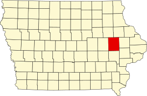
[3] Name on the Register [4] Image Date listed [5] Location City or town Description 1 Henry D. and Juliana (Wortz) Albright House Upload image August 27, 2020 (# 100005495 224 1st St. SW 41°55′23″N 91°25′09″W / 41.923136°N 91.419052°W / 41.923136; -91.419052 (Henry D. and Juliana (Wortz) Albright House ) Mount Vernon 2 Robert and Esther Armstrong House Robert and Esther Armstrong House November 16, 1989 (# 89002009 370 34th St., SE. 41°59′05″N 91°37′02″W / 41.984722°N 91.617222°W / 41.984722; -91.617222 (Robert and Esther Armstrong House ) Cedar Rapids 3 Ash Park Historic District Ash Park Historic District September 13, 1993 (# 93000899 5th-8th Aves. N., between 6th and 8th Sts., NW. 41°55′40″N 91°25′15″W / 41.927778°N 91.420833°W / 41.927778; -91.420833 (Ash Park Historic District ) Mount Vernon 4 Ausadie Building Ausadie Building December 6, 2004 (# 04001324 845 1st Ave., SE. 41°58′59″N 91°39′37″W / 41.983056°N 91.660278°W / 41.983056; -91.660278 (Ausadie Building ) Cedar Rapids 5 A. T. Averill House A. T. Averill House November 28, 1978 (# 78001236 1120 2nd Ave., SE 41°59′03″N 91°39′25″W / 41.984167°N 91.656944°W / 41.984167; -91.656944 (A. T. Averill House ) Cedar Rapids 6 Glenn M. and Edith Averill House Glenn M. and Edith Averill House July 27, 2015 (# 15000472 616 4th Ave., SE 41°58′45″N 91°39′40″W / 41.979213°N 91.661222°W / 41.979213; -91.661222 (Glenn M. and Edith Averill House ) Cedar Rapids 7 B Avenue NE Historic District B Avenue NE Historic District September 11, 2013 (# 13000692 Along B Avenue, NE, from 15th to 21st Streets 41°59′35″N 91°38′54″W / 41.993181°N 91.648330°W / 41.993181; -91.648330 (B Avenue NE Historic District ) Cedar Rapids 8 Augustus and Elizabeth (Huntsberger) Bauman House Augustus and Elizabeth (Huntsberger) Bauman House August 27, 2020 (# 100005489 601 1st Ave. SW 41°55′06″N 91°25′16″W / 41.918258°N 91.421172°W / 41.918258; -91.421172 (Augustus and Elizabeth (Huntsberger) Bauman House ) Mount Vernon 9 Beach School Beach School September 16, 1982 (# 82002630 Northwest of Mount Vernon off U.S. Route 30 41°59′28″N 91°28′45″W / 41.991111°N 91.479167°W / 41.991111; -91.479167 (Beach School ) Mount Vernon 10 Best Oil and Refining Company Service Station Best Oil and Refining Company Service Station June 27, 2014 (# 14000359 624 12th Ave., SE 41°58′22″N 91°39′15″W / 41.972770°N 91.654117°W / 41.972770; -91.654117 (Best Oil and Refining Company Service Station ) Cedar Rapids 11 Bethel African Methodist Episcopal Church Bethel African Methodist Episcopal Church December 18, 2013 (# 13000927 512 6th Street, SE 41°58′39″N 91°39′37″W / 41.977628°N 91.660174°W / 41.977628; -91.660174 (Bethel African Methodist Episcopal Church ) Cedar Rapids 12 Bever Woods Historic District Upload image March 2, 2023 (# 100008668 Grande Ave. SE, 21st St. SE, Bever Ave. SE 41°59′07″N 91°38′02″W / 41.985253°N 91.633908°W / 41.985253; -91.633908 (Bever Woods Historic District ) Cedar Rapids 13 Bohemian Commercial Historic District Bohemian Commercial Historic District December 20, 2002 (# 02001539 1000 to 1300 blocks of 3rd St., SE. and the 100 and 200 blocks of 14th Ave., SE.March 12, 2012 , refnum 12000096): Roughly bounded by 9th Ave. SE., 4th St. SE., 14th Ave. SE., 15th Ave. SW., C St. SW., 17th Ave SW. & A St. SW. 41°58′10″N 91°38′49″W / 41.969444°N 91.646944°W / 41.969444; -91.646944 (Bohemian Commercial Historic District ) Cedar Rapids Cedar Rapids, Iowa Multiple Property Submission 14 James W. and Ida G. Bowman House James W. and Ida G. Bowman House September 14, 2002 (# 02001015 1372 8th Ave. 42°02′03″N 91°35′40″W / 42.034167°N 91.594444°W / 42.034167; -91.594444 (James W. and Ida G. Bowman House ) Marion 15 Braska House Braska House March 21, 1979 (# 79000911 889 2nd Ave. 42°01′43″N 91°36′02″W / 42.028611°N 91.600556°W / 42.028611; -91.600556 (Braska House ) Marion 16 Brown Apartments Brown Apartments March 17, 2010 (# 10000075 1234 4th Ave. SE 41°58′57″N 91°39′17″W / 41.982625°N 91.654806°W / 41.982625; -91.654806 (Brown Apartments ) Cedar Rapids 17 Burlington, Cedar Rapids, and Minnesota Railroad: Walker Station Burlington, Cedar Rapids, and Minnesota Railroad: Walker Station February 14, 1978 (# 78001242 Between Rowley and Washington Sts. 42°17′03″N 91°42′52″W / 42.284167°N 91.714444°W / 42.284167; -91.714444 (Burlington, Cedar Rapids, and Minnesota Railroad: Walker Station ) Walker 18 C.S.P.S. Hall C.S.P.S. Hall November 29, 1978 (# 78001237 1105 3rd St., SE. 41°58′15″N 91°39′31″W / 41.970833°N 91.658611°W / 41.970833; -91.658611 (C.S.P.S. Hall ) Cedar Rapids A building of the Czech-Slovak Protective Society , built in 1891. 19 Calder Houses Calder Houses January 18, 1978 (# 78001238 1214 and 1216 2nd Ave., SE. 41°59′04″N 91°39′23″W / 41.984444°N 91.656389°W / 41.984444; -91.656389 (Calder Houses ) Cedar Rapids 20 Cedar Rapids 2nd Avenue SE. Automobile Row Historic District Cedar Rapids 2nd Avenue SE. Automobile Row Historic District October 23, 2015 (# 15000749 Roughly 2nd to 3rd Aves., SE., from 6th to 8th Sts., SE. 41°58′49″N 91°39′45″W / 41.9803°N 91.6624°W / 41.9803; -91.6624 (Cedar Rapids 2nd Avenue SE. Automobile Row Historic District ) Cedar Rapids 21 Cedar Rapids Central Business District Commercial Historic District Cedar Rapids Central Business District Commercial Historic District November 2, 2015 (# 15000757 Roughly bounded by 1st & 5th Aves., SE. & 5th & 2nd Sts., SE. 41°58′39″N 91°39′56″W / 41.9775°N 91.6655°W / 41.9775; -91.6655 (Cedar Rapids Central Business District Commercial Historic District ) Cedar Rapids 22 Cedar Rapids Central Fire Station Cedar Rapids Central Fire Station April 29, 2014 (# 14000175 427 1st St., SE 41°58′29″N 91°40′00″W / 41.974747°N 91.666746°W / 41.974747; -91.666746 (Cedar Rapids Central Fire Station ) Cedar Rapids 23 Cedar Rapids Milk Condensing Company Cedar Rapids Milk Condensing Company May 8, 2017 (# 100000966 525 Valor Way, SW 41°58′21″N 91°40′07″W / 41.972447°N 91.668662°W / 41.972447; -91.668662 (Cedar Rapids Milk Condensing Company ) Cedar Rapids 24 Cedar Rapids Post Office and Public Building Cedar Rapids Post Office and Public Building November 10, 1982 (# 82000413 305 2nd Ave., SE. 41°58′42″N 91°39′58″W / 41.978333°N 91.666111°W / 41.978333; -91.666111 (Cedar Rapids Post Office and Public Building ) Cedar Rapids 25 Cedar Rapids Pump Company Factory and Warehouse Cedar Rapids Pump Company Factory and Warehouse November 6, 2012 (# 12000907 605 G Avenue NW 41°58′48″N 91°40′53″W / 41.97993°N 91.68138°W / 41.97993; -91.68138 (Cedar Rapids Pump Company Factory and Warehouse ) Cedar Rapids 26 Central City Commercial Historic District Central City Commercial Historic District March 18, 2003 (# 02001027 300 and 400 blocks of E. Main St., N. 4th St. to Commercial 42°12′15″N 91°31′28″W / 42.204167°N 91.524444°W / 42.204167; -91.524444 (Central City Commercial Historic District ) Central City 27 Chain Lakes Bridge Chain Lakes Bridge May 15, 1998 (# 98000529 Pedestrian trail over the Cedar River 42°02′59″N 91°46′32″W / 42.049722°N 91.775556°W / 42.049722; -91.775556 (Chain Lakes Bridge ) Hiawatha 28 Coggon Commercial Historic District Upload image August 7, 2019 (# 100004229 East Main Street between 1st Street South and 3rd Street North 42°16′49″N 91°31′51″W / 42.2802°N 91.5307°W / 42.2802; -91.5307 (Coggon Commercial Historic District ) Coggon 29 Coggon Public School Coggon Public School September 12, 2016 (# 16000605 408 E. Linn St. 42°16′51″N 91°31′40″W / 42.280850°N 91.527688°W / 42.280850; -91.527688 (Coggon Public School ) Coggon 30 Consistory Building No. 2 Consistory Building No. 2 November 20, 1998 (# 98001327 616 A Ave., NE. 41°58′58″N 91°39′52″W / 41.982778°N 91.664444°W / 41.982778; -91.664444 (Consistory Building No. 2 ) Cedar Rapids Also known as Scottish Rite Temple 31 Cornell College-Mount Vernon Historic District Cornell College-Mount Vernon Historic District July 18, 1980 (# 80001456 Roughly bounded by railroad tracks, College Boulevard, N. 10th, N. 8th, and S. 3rd Aves., and N. 2nd and S. 4th Sts. 41°55′34″N 91°25′29″W / 41.926111°N 91.424722°W / 41.926111; -91.424722 (Cornell College-Mount Vernon Historic District ) Mount Vernon 32 William and Sue Damour House William and Sue Damour House January 16, 1997 (# 96001586 1844 2nd Ave., SE. 41°59′30″N 91°38′38″W / 41.991667°N 91.643889°W / 41.991667; -91.643889 (William and Sue Damour House ) Cedar Rapids 33 Dewitt-Harman Archeological Site Upload image September 14, 2000 (# 00001077 Address Restricted Cedar Rapids 34 George B. Douglas House George B. Douglas House September 9, 1982 (# 82002628 800 2nd Ave., SE. 41°58′56″N 91°39′39″W / 41.982222°N 91.660833°W / 41.982222; -91.660833 (George B. Douglas House ) Cedar Rapids 35 Dows Street Historic District Dows Street Historic District November 14, 2003 (# 02001026 Dows St. between State and Main Sts. 41°52′23″N 91°35′10″W / 41.873122°N 91.586117°W / 41.873122; -91.586117 (Dows Street Historic District ) Ely 36 William and Phebe C. Dunn House William and Phebe C. Dunn House September 4, 2013 (# 13000663 524 10th St. 42°01′54″N 91°35′58″W / 42.031747°N 91.599326°W / 42.031747; -91.599326 (William and Phebe C. Dunn House ) Marion 37 Ely School House Ely School House September 20, 2006 (# 06000859 1570 Rowley St. 41°52′17″N 91°35′05″W / 41.871389°N 91.584722°W / 41.871389; -91.584722 (Ely School House ) Ely 38 Evans Manufacturing Company Building Evans Manufacturing Company Building April 15, 1999 (# 99000450 301 6th Ave., SE. 41°58′32″N 91°39′46″W / 41.975556°N 91.662778°W / 41.975556; -91.662778 (Evans Manufacturing Company Building ) Cedar Rapids 39 First Avenue Bridge First Avenue Bridge May 15, 1998 (# 98000530 U.S. Route 151 over the Cedar River 41°58′36″N 91°40′20″W / 41.976667°N 91.672222°W / 41.976667; -91.672222 (First Avenue Bridge ) Cedar Rapids 40 First Church of Christ, Scientist First Church of Christ, Scientist October 10, 2017 (# 100001698 1246 2nd Ave. SE. 41°59′05″N 91°39′20″W / 41.984785°N 91.655694°W / 41.984785; -91.655694 (First Church of Christ, Scientist ) Cedar Rapids 41 First Presbyterian Church of Marion, Iowa First Presbyterian Church of Marion, Iowa July 24, 1992 (# 92000924 802 12th St. 42°02′04″N 91°35′50″W / 42.03441111°N 91.59709444°W / 42.03441111; -91.59709444 (First Presbyterian Church of Marion, Iowa ) Marion 42 First Universalist Church of Cedar Rapids First Universalist Church of Cedar Rapids August 24, 1978 (# 78001239 600 3rd Ave., SE. 41°58′48″N 91°39′44″W / 41.98°N 91.662222°W / 41.98; -91.662222 (First Universalist Church of Cedar Rapids ) Cedar Rapids Demolished in 2011. [6] 43 Granger House Granger House August 13, 1976 (# 76000781 970 10th St. 42°02′09″N 91°35′59″W / 42.035947°N 91.599644°W / 42.035947; -91.599644 (Granger House ) Marion 44 Grant Vocational High School Grant Vocational High School October 13, 2015 (# 15000728 346 2nd Ave., SW. 41°58′27″N 91°40′38″W / 41.9742°N 91.6772°W / 41.9742; -91.6772 (Grant Vocational High School ) Cedar Rapids 45 Grant Wood's "Fall Plowing" Rural Historic Landscape District Grant Wood's "Fall Plowing" Rural Historic Landscape District May 30, 2003 (# 03000476 0.5 miles (0.80 km) north of the junction of Matsell Ln. and Stone City Rd. 42°06′55″N 91°23′20″W / 42.115278°N 91.388889°W / 42.115278; -91.388889 (Grant Wood's "Fall Plowing" Rural Historic Landscape District ) Viola 46 Douglas and Charlotte Grant House Douglas and Charlotte Grant House November 9, 1988 (# 88002145 3400 Adel St., SE. 42°00′42″N 91°37′20″W / 42.011667°N 91.622222°W / 42.011667; -91.622222 (Douglas and Charlotte Grant House ) Marion 47 Hamilton Brothers Building Hamilton Brothers Building September 8, 1994 (# 94001098 401 1st St., SE. 41°58′30″N 91°40′02″W / 41.975°N 91.667222°W / 41.975; -91.667222 (Hamilton Brothers Building ) Cedar Rapids 48 Harper and McIntire Company Warehouse Harper and McIntire Company Warehouse November 2, 2015 (# 15000758 411 6th Ave., SE. 41°58′34″N 91°39′42″W / 41.9760°N 91.6617°W / 41.9760; -91.6617 (Harper and McIntire Company Warehouse ) Cedar Rapids 49 Dr. Percy and Lileah Harris House Upload image February 4, 2021 (# 100006115 3626 Bever Ave. SE 41°59′04″N 91°36′56″W / 41.984378°N 91.615679°W / 41.984378; -91.615679 (Dr. Percy and Lileah Harris House ) Cedar Rapids Twentieth Century African American Civil Rights-related Resources in Iowa MPS 50 Hickman-Nietert-Odd Fellows Building Upload image November 3, 2023 (# 100009434 102-106 South Main Ave. 42°08′53″N 91°37′06″W / 42.148050°N 91.618285°W / 42.148050; -91.618285 (Hickman-Nietert-Odd Fellows Building ) Alburnett 51 Highwater Rock Highwater Rock November 17, 1977 (# 77000535 Cedar River near 1st Ave. and 1st St., NE. 41°58′43″N 91°40′19″W / 41.978611°N 91.671944°W / 41.978611; -91.671944 (Highwater Rock ) Cedar Rapids 52 Hotel Roosevelt Hotel Roosevelt May 1, 1991 (# 91000534 200 1st Ave., NE. 41°58′45″N 91°40′06″W / 41.979167°N 91.668333°W / 41.979167; -91.668333 (Hotel Roosevelt ) Cedar Rapids 53 IANR Railroad Underpass IANR Railroad Underpass May 15, 1998 (# 98000528 Ely Rd. 41°56′40″N 91°38′12″W / 41.944444°N 91.636667°W / 41.944444; -91.636667 (IANR Railroad Underpass ) Cedar Rapids 54 Indian Creek Bridge Indian Creek Bridge May 15, 1998 (# 98000514 Artesian Rd. over Indian Creek 41°58′02″N 91°34′52″W / 41.967222°N 91.581111°W / 41.967222; -91.581111 (Indian Creek Bridge ) Cedar Rapids 55 Iowa Building Iowa Building February 17, 1983 (# 83000385 221 4th Ave., SE. 41°58′36″N 91°39′53″W / 41.976667°N 91.664722°W / 41.976667; -91.664722 (Iowa Building ) Cedar Rapids 56 Iowa State Highway Commission, District 6 Building Iowa State Highway Commission, District 6 Building January 17, 2017 (# 100000486 430 16th Ave., SW. 41°57′44″N 91°40′33″W / 41.9622°N 91.6759°W / 41.9622; -91.6759 (Iowa State Highway Commission, District 6 Building ) Cedar Rapids 57 Iowa Wind Mill and Pump Company Office and Warehouse Iowa Wind Mill and Pump Company Office and Warehouse October 31, 2012 (# 12000890 42 7th Ave., SW. 41°58′19″N 91°40′03″W / 41.972062°N 91.667608°W / 41.972062; -91.667608 (Iowa Wind Mill and Pump Company Office and Warehouse ) Cedar Rapids 58 Jan F. and Antonie Janko Farmstead District Jan F. and Antonie Janko Farmstead District September 14, 2000 (# 00001079 4021 Vista Rd. 41°52′25″N 91°36′18″W / 41.873611°N 91.605°W / 41.873611; -91.605 (Jan F. and Antonie Janko Farmstead District ) Ely 59 King Memorial Chapel King Memorial Chapel November 7, 1976 (# 76000782 Cornell College campus 41°55′30″N 91°25′25″W / 41.925°N 91.423611°W / 41.925; -91.423611 (King Memorial Chapel ) Mount Vernon 60 Adams R., Frederick L. and Martha (Taylor) Knott House Adams R., Frederick L. and Martha (Taylor) Knott House August 27, 2020 (# 100005488 417 A Ave. SE 41°55′09″N 91°25′08″W / 41.919047°N 91.418952°W / 41.919047; -91.418952 (Adams R., Frederick L. and Martha (Taylor) Knott House ) Mount Vernon 61 Samuel M. Lane House Samuel M. Lane House September 14, 2002 (# 02001014 1776 8th Ave. 42°02′03″N 91°35′31″W / 42.034167°N 91.591944°W / 42.034167; -91.591944 (Samuel M. Lane House ) Marion 62 Lattner Auditorium Building Lattner Auditorium Building February 17, 1983 (# 83000386 217 4th Ave., SE. 41°58′35″N 91°39′55″W / 41.976389°N 91.665278°W / 41.976389; -91.665278 (Lattner Auditorium Building ) Cedar Rapids 63 Lesinger Block Lesinger Block December 24, 1997 (# 97001544 1317 3rd St., SE. 41°57′46″N 91°39′34″W / 41.962778°N 91.659444°W / 41.962778; -91.659444 (Lesinger Block ) Cedar Rapids 64 Lisbon Main Street Historic District Lisbon Main Street Historic District November 1, 2019 (# 100004555 101-145 E. and W. Main St., 102-122 W. Main St. 41°55′17″N 91°23′08″W / 41.9213°N 91.3855°W / 41.9213; -91.3855 (Lisbon Main Street Historic District ) Lisbon 65 Lisbon Methodist Church Lisbon Methodist Church January 5, 2016 (# 15000952 200 E. Market St. 41°55′21″N 91°23′00″W / 41.922540°N 91.383472°W / 41.922540; -91.383472 (Lisbon Methodist Church ) Lisbon 66 Lustron Home No. 02102 Lustron Home No. 02102 August 25, 2004 (# 04000898 2009 Williams Boulevard, SW. 41°58′15″N 91°42′03″W / 41.970833°N 91.700833°W / 41.970833; -91.700833 (Lustron Home No. 02102 ) Cedar Rapids 67 Marion Carnegie Public Library Marion Carnegie Public Library March 25, 1994 (# 94000260 1298 7th Ave. 42°02′01″N 91°35′45″W / 42.03355°N 91.59597222°W / 42.03355; -91.59597222 (Marion Carnegie Public Library ) Marion 68 Marion Commercial Historic District Marion Commercial Historic District November 18, 2009 (# 09000930 560-748 10th St., 958-1298 7th Ave., 760-96 11th St., 766-76 13th St., 1108 8th Ave., and 969 6th Ave. 42°02′00″N 91°35′58″W / 42.033358°N 91.599314°W / 42.033358; -91.599314 (Marion Commercial Historic District ) Marion 69 Matsell Bridge Matsell Bridge May 15, 1998 (# 98000534 Natsell Park Rd. over the Wapsipinicon River 42°07′49″N 91°23′01″W / 42.130278°N 91.383611°W / 42.130278; -91.383611 (Matsell Bridge ) Springville 70 May's Island Historic District May's Island Historic District October 19, 1978 (# 78001240 Between 1st and 5th Aves. on May Island 41°58′54″N 91°40′10″W / 41.981667°N 91.669444°W / 41.981667; -91.669444 (May's Island Historic District ) Cedar Rapids 71 James H. and Mayetta (Degrush) McCartney House James H. and Mayetta (Degrush) McCartney House August 27, 2020 (# 100005498 214 2nd St. SE 41°55′14″N 91°24′59″W / 41.920418°N 91.416300°W / 41.920418; -91.416300 (James H. and Mayetta (Degrush) McCartney House ) Mount Vernon 72 Joseph P. Mentzer House Joseph P. Mentzer House April 12, 1982 (# 82002629 2233 3rd Ave. 42°01′49″N 91°35′26″W / 42.030278°N 91.590556°W / 42.030278; -91.590556 (Joseph P. Mentzer House ) Marion 73 Meyers Farmstead Historic District Upload image February 22, 2021 (# 100006183 300 West Market St. 41°55′23″N 91°23′24″W / 41.923010°N 91.389931°W / 41.923010; -91.389931 (Meyers Farmstead Historic District ) Lisbon 74 Josias L. and Elizabeth A. Minor Farmstead District Josias L. and Elizabeth A. Minor Farmstead District September 14, 2000 (# 00001080 7500 Ely Rd. 41°54′19″N 91°36′51″W / 41.905278°N 91.614167°W / 41.905278; -91.614167 (Josias L. and Elizabeth A. Minor Farmstead District ) Ely 75 Monroe Elementary School Historic District Monroe Elementary School Historic District October 23, 2015 (# 15000751 3200 Pioneer Ave., SE. 41°58′11″N 91°37′12″W / 41.9697°N 91.6199°W / 41.9697; -91.6199 (Monroe Elementary School Historic District ) Cedar Rapids 76 Joseph and Clara Amanda H. Moorhead House Joseph and Clara Amanda H. Moorhead House September 14, 2000 (# 00001081 88 Palisades Access Rd. 41°51′59″N 91°32′08″W / 41.866389°N 91.535556°W / 41.866389; -91.535556 (Joseph and Clara Amanda H. Moorhead House ) Ely 77 Moslem Temple Moslem Temple May 15, 1996 (# 96000516 1335 9th St., NW. 41°59′11″N 91°41′02″W / 41.986389°N 91.683889°W / 41.986389; -91.683889 (Moslem Temple ) Cedar Rapids 78 Mount Vernon Commercial Historic District Mount Vernon Commercial Historic District September 13, 1993 (# 93000898 1st St. between 2nd and 1st Aves., N. 41°55′20″N 91°25′01″W / 41.922222°N 91.416944°W / 41.922222; -91.416944 (Mount Vernon Commercial Historic District ) Mount Vernon 79 Notbohm Mill Archaeological District Upload image March 29, 2000 (# 99001383 Address Restricted Alburnett 80 Oak Hill Cemetery Historic District Oak Hill Cemetery Historic District May 8, 2013 (# 13000243 Roughly bounded by Mt. Vernon Rd., SE., 15th St., SE., S.& E. lot lines 41°58′33″N 91°38′45″W / 41.975908°N 91.645767°W / 41.975908; -91.645767 (Oak Hill Cemetery Historic District ) Cedar Rapids 81 Odd Fellows Hall Odd Fellows Hall October 10, 1985 (# 85003008 Troy Mills Rd. 42°17′20″N 91°40′57″W / 42.288889°N 91.6825°W / 42.288889; -91.6825 (Odd Fellows Hall ) Troy Mills 82 Our Mother of Sorrows Grotto Historic District Our Mother of Sorrows Grotto Historic District January 21, 2015 (# 14000213 1330 Elmhurst Dr., NE. (on the Mount Mercy University campus) 42°00′10″N 91°39′12″W / 42.0028°N 91.6534°W / 42.0028; -91.6534 (Our Mother of Sorrows Grotto Historic District ) Cedar Rapids 83 Paramount Theater Building Paramount Theater Building August 26, 1976 (# 76000778 121-127 3rd Ave., SE. 41°58′36″N 91°40′00″W / 41.976667°N 91.666667°W / 41.976667; -91.666667 (Paramount Theater Building ) Cedar Rapids 84 Dr. Luther L. and Susette E. (Baker) Pease House Dr. Luther L. and Susette E. (Baker) Pease House August 27, 2020 (# 100005491 600 1st Ave. South 41°55′05″N 91°25′13″W / 41.918076°N 91.420339°W / 41.918076; -91.420339 (Dr. Luther L. and Susette E. (Baker) Pease House ) Mount Vernon 85 People's Savings Bank People's Savings Bank March 29, 1978 (# 78001241 101 3rd Ave., SW. 41°58′28″N 91°40′18″W / 41.974444°N 91.671667°W / 41.974444; -91.671667 (People's Savings Bank ) Cedar Rapids 86 Charles W. and Nellie Perkins House Charles W. and Nellie Perkins House May 9, 2002 (# 02000456 1228 3rd Ave., SE. 41°59′02″N 91°39′18″W / 41.983889°N 91.655°W / 41.983889; -91.655 (Charles W. and Nellie Perkins House ) Cedar Rapids 87 Podhajsky-Jansa Farmstead District Podhajsky-Jansa Farmstead District September 14, 2000 (# 00001082 Hoosier Creek Rd. 41°51′41″N 91°36′30″W / 41.861389°N 91.608333°W / 41.861389; -91.608333 (Podhajsky-Jansa Farmstead District ) Ely 88 Pucker Street Historic District Pucker Street Historic District September 14, 2002 (# 02001013 Bounded by 13th St., 9th Ave., 20th St., and 8th Ave. 42°02′03″N 91°35′34″W / 42.034167°N 91.592778°W / 42.034167; -91.592778 (Pucker Street Historic District ) Marion 89 Glenn O. and Lucy O. Pyle House Glenn O. and Lucy O. Pyle House September 14, 2002 (# 02001016 1540 8th Ave. 42°02′03″N 91°35′35″W / 42.034167°N 91.593056°W / 42.034167; -91.593056 (Glenn O. and Lucy O. Pyle House ) Marion 90 Redmond Park-Grande Avenue Historic District Redmond Park-Grande Avenue Historic District September 10, 2001 (# 01000994 Roughly bounded by U.S. Route 151 , 19th St., and Washington Ave. 41°59′16″N 91°38′42″W / 41.987778°N 91.645°W / 41.987778; -91.645 (Redmond Park-Grande Avenue Historic District ) Cedar Rapids 91 George W. and Mary J. (Maxwell) Robinson House George W. and Mary J. (Maxwell) Robinson House August 27, 2020 (# 100005494 514 1st St. SE 41°55′12″N 91°24′45″W / 41.919904°N 91.412573°W / 41.919904; -91.412573 (George W. and Mary J. (Maxwell) Robinson House ) Mount Vernon 92 St. James United Methodist Church St. James United Methodist Church December 15, 2015 (# 15000894 1430 Ellis Blvd., NW 41°59′15″N 91°40′57″W / 41.987453°N 91.682555°W / 41.987453; -91.682555 (St. James United Methodist Church ) Cedar Rapids 93 St. Paul Methodist Episcopal Church St. Paul Methodist Episcopal Church June 27, 1985 (# 85001376 1340 3rd Ave., SE 41°59′08″N 91°39′10″W / 41.985556°N 91.652778°W / 41.985556; -91.652778 (St. Paul Methodist Episcopal Church ) Cedar Rapids 94 Second and Third Avenue Historic District Second and Third Avenue Historic District August 10, 2000 (# 00000926 1400 to 1800 blocks of 2nd Ave., SE. and 3rd Ave., SE. 41°59′14″N 91°38′12″W / 41.987222°N 91.636667°W / 41.987222; -91.636667 (Second and Third Avenue Historic District ) Cedar Rapids 95 Security Building Security Building December 7, 1977 (# 77000536 2nd Ave. and 2nd St., SE 41°58′40″N 91°40′03″W / 41.977778°N 91.6675°W / 41.977778; -91.6675 (Security Building ) Cedar Rapids 96 Seminole Valley Farmstead Seminole Valley Farmstead October 8, 1976 (# 76000779 West of Cedar Rapids 42°00′13″N 91°43′38″W / 42.003611°N 91.727222°W / 42.003611; -91.727222 (Seminole Valley Farmstead ) Cedar Rapids 97 Martin L. and Mary Jane (Yount) Shantz House Martin L. and Mary Jane (Yount) Shantz House August 27, 2020 (# 100005499 303 A Ave. SE 41°55′13″N 91°25′04″W / 41.920214°N 91.417871°W / 41.920214; -91.417871 (Martin L. and Mary Jane (Yount) Shantz House ) Mount Vernon 98 Shores-Mueller Company Shores-Mueller Company June 22, 2020 (# 100005298 700 16th St. NE 41°59′42″N 91°39′19″W / 41.994950°N 91.655399°W / 41.994950; -91.655399 (Shores-Mueller Company ) Cedar Rapids 99 Sinclair Building-Smulekoffs Furniture Store Sinclair Building-Smulekoffs Furniture Store 2016-05-Shores-Mueller Company03(# 16000214 97 3rd Ave., SE 41°58′34″N 91°40′05″W / 41.976134°N 91.668179°W / 41.976134; -91.668179 (Sinclair Building-Smulekoffs Furniture Store ) Cedar Rapids 100 T.M. Sinclair Mansion T.M. Sinclair Mansion December 12, 1976 (# 76000780 2160 Linden Dr., SE 41°59′31″N 91°38′19″W / 41.991944°N 91.638611°W / 41.991944; -91.638611 (T.M. Sinclair Mansion ) Cedar Rapids 101 James J. and Anna J. (Linean) Smith House #1 James J. and Anna J. (Linean) Smith House #1 August 27, 2020 (# 100005496 316 3rd Ave. SW 41°55′16″N 91°25′15″W / 41.921010°N 91.420835°W / 41.921010; -91.420835 (James J. and Anna J. (Linean) Smith House #1 ) Mount Vernon 102 James J. and Anna J. (Linean) Smith House #2 James J. and Anna J. (Linean) Smith House #2 August 27, 2020 (# 100005497 201 2nd Ave. NW 41°55′26″N 91°25′03″W / 41.923947°N 91.417389°W / 41.923947; -91.417389 (James J. and Anna J. (Linean) Smith House #2 ) Mount Vernon 103 Sokol Gymnasium Sokol Gymnasium May 14, 2013 (# 13000274 417 3rd St., SE 41°58′34″N 91°39′53″W / 41.976164°N 91.664609°W / 41.976164; -91.664609 (Sokol Gymnasium ) Cedar Rapids 104 Harrison Stuckslager House Harrison Stuckslager House October 1, 1979 (# 79000910 207 N. Jackson St. 41°55′25″N 91°23′05″W / 41.923611°N 91.384722°W / 41.923611; -91.384722 (Harrison Stuckslager House ) Lisbon 105 Sumner School Sumner School May 8, 2013 (# 13000242 877 W. Mount Vernon Rd. 41°56′32″N 91°27′05″W / 41.942145°N 91.451327°W / 41.942145; -91.451327 (Sumner School ) Mount Vernon vicinity 106 Taylor-Van Note Taylor-Van Note October 10, 1985 (# 85003009 4600 Blairs Ferry Rd. 42°02′31″N 91°43′42″W / 42.041944°N 91.728333°W / 42.041944; -91.728333 (Taylor-Van Note ) Cedar Rapids 107 Terrace Park Historic District Terrace Park Historic District October 25, 2006 (# 06000953 Roughly bounded by 10th Ave., 9th Ave., 11th St., and the eastern side of 12th St. 42°02′15″N 91°35′50″W / 42.0375°N 91.597222°W / 42.0375; -91.597222 (Terrace Park Historic District ) Marion 108 Torrance House Torrance House July 7, 1983 (# 83000387 South of Lisbon 41°53′44″N 91°23′48″W / 41.895556°N 91.396667°W / 41.895556; -91.396667 (Torrance House ) Lisbon 109 Upper Paris Bridge Upper Paris Bridge May 15, 1998 (# 98000532 Sutton Rd. over the Wapsipinicon River 42°14′40″N 91°35′04″W / 42.244444°N 91.584444°W / 42.244444; -91.584444 (Upper Paris Bridge ) Coggon 110 WCF & N Center Point Depot and Substation WCF & N Center Point Depot and Substation March 7, 2018 (# 100002185 700 Washington St. 42°11′35″N 91°46′53″W / 42.193071°N 91.781364°W / 42.193071; -91.781364 (WCF & N Center Point Depot and Substation ) Center Point 111 Elijah D. and Mary J. (Adams) Waln House Elijah D. and Mary J. (Adams) Waln House August 27, 2020 (# 100005492 323 3rd St. NE 41°55′22″N 91°24′44″W / 41.922891°N 91.412334°W / 41.922891; -91.412334 (Elijah D. and Mary J. (Adams) Waln House ) Mount Vernon 112 Wesley West House Wesley West House June 27, 1985 (# 85001380 Palisades Rd. 41°55′04″N 91°25′43″W / 41.917778°N 91.428611°W / 41.917778; -91.428611 (Wesley West House ) Mount Vernon 113 West Side Third Avenue SW Commercial Historic District West Side Third Avenue SW Commercial Historic District June 13, 2014 (# 14000323 3rd Avenue SW, between 1st and 3rd streets SW 41°58′27″N 91°40′24″W / 41.974201°N 91.673201°W / 41.974201; -91.673201 (West Side Third Avenue SW Commercial Historic District ) Cedar Rapids 114 Whittier Friends Meeting House Whittier Friends Meeting House July 29, 1993 (# 93000653 Junction of County Roads E34 and X20 42°05′35″N 91°27′50″W / 42.093056°N 91.463889°W / 42.093056; -91.463889 (Whittier Friends Meeting House ) Whittier 115 Wickiup Hill Late Woodland Village Site Upload image January 20, 2022 (# 100007333 Address Restricted Toddville vicinity Archaeology of the Wickiup Hill Locality in Linn County, Iowa MPS 116 Wickiup Hill Middle to Late Archaic Camp Site Upload image January 20, 2022 (# 100007334 Address Restricted Toddville vicinity Archaeology of the Wickiup Hill Locality in Linn County, Iowa MPS 117 Wickiup Hill Mound Group No. 1 Upload image January 20, 2022 (# 100007335 Address Restricted Toddville vicinity Archaeology of the Wickiup Hill Locality in Linn County, Iowa MPS 118 Wickiup Hill Mound Group No. 2 Upload image January 20, 2022 (# 100007336 Address Restricted Toddville vicinity Archaeology of the Wickiup Hill Locality in Linn County, Iowa MPS 119 Wickiup Hill Mound Group No. 3 Upload image January 20, 2022 (# 100007337 Address Restricted Toddville vicinity Archaeology of the Wickiup Hill Locality in Linn County, Iowa MPS 120 Wickiup Hill Mound Group No. 4 Upload image January 20, 2022 (# 100007338 Address Restricted Toddville vicinity Archaeology of the Wickiup Hill Locality in Linn County, Iowa MPS 121 Col. John Q. and Rowena (Camp) Wilds House Col. John Q. and Rowena (Camp) Wilds House August 27, 2020 (# 100005490 113 2nd Ave. NW 41°55′24″N 91°25′04″W / 41.923449°N 91.417879°W / 41.923449; -91.417879 (Col. John Q. and Rowena (Camp) Wilds House ) Mount Vernon 122 Witwer Grocery Company Building Witwer Grocery Company Building May 1, 1998 (# 98000386 905 3rd St., SE. 41°58′21″N 91°39′38″W / 41.9725°N 91.660556°W / 41.9725; -91.660556 (Witwer Grocery Company Building ) Cedar Rapids 123 Philip A. Wolff House and Carriage House Philip A. Wolff House and Carriage House October 7, 1982 (# 82000414 1420 Seminole Ave., NW. 41°58′43″N 91°41′30″W / 41.978611°N 91.691667°W / 41.978611; -91.691667 (Philip A. Wolff House and Carriage House ) Cedar Rapids Restored property now Belmont Hill Victorian Bed & Breakfast