
Oakland County is a county in the U.S. state of Michigan. It is part of the metropolitan Detroit area, located northwest of the city. As of the 2010 census, its population was 1,202,362, making it the second-most populous county in Michigan, behind neighboring Wayne County. The county seat is Pontiac. The county was founded in 1819 and organized in 1820.

Shelby Charter Township, officially the Charter Township of Shelby, is a charter township and census-designated place located in Macomb County in the U.S. state of Michigan. The township, an affluent northern suburb of Detroit, is located roughly 15 miles north of the city. As of the 2000 census, the township had a total population of 65,159. The 2010 Census places the population at 73,804. Shelby Charter Township is one of the fastest growing communities in Metro Detroit.
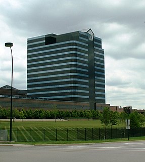
Auburn Hills is a city in Oakland County in the U.S. state of Michigan. The population was 21,412 at the 2010 census.

Lake Angelus is a city in Oakland County in the U.S. state of Michigan. As of the 2010 census, the city had a population of 290, which ranks it as Michigan's least-populated city. Lake Angelus consistently ranks as the city in Michigan with the 5th highest per capita income.

Orion Charter Township is a charter township of Oakland County, Michigan, United States. The population was 35,394 at the 2010 census.
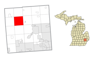
Oxford Township, officially the Charter Township of Oxford, is a charter township in Oakland County in the U.S. state of Michigan. The population was 20,526 at the 2010 census.
Pontiac is a city and county seat of Oakland County in the U.S. state of Michigan. As of the 2010 census, the city had a total population of 59,515. A northern suburb of Metro Detroit, Pontiac is about 20 miles (32.2 km) northwest of Detroit.
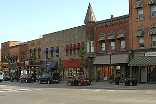
Rochester Hills is a city in Oakland County in the U.S. state of Michigan. As of the 2010 census, the city had a total population of 70,995.
Springfield Charter Township is a charter township of Oakland County in the U.S. state of Michigan. As of the 2010 census, the township population was 13,940. The township was named for the numerous springs in the area.

Waterford Township is a charter township in the geographic center of Oakland County, Michigan, United States.
Bloomfield Township, officially the Charter Township of Bloomfield, is a charter township of Oakland County in the U.S. state of Michigan. As of the 2010 census, the township population was 41,070. This area is often referred to simply as Bloomfield by residents and visitors alike. This Metro Detroit township was organized in 1827, the first township to be established in Oakland County. It almost completely surrounds the city of Bloomfield Hills. In 2014, Bloomfield Township was ranked the most expensive community in which to live in the state of Michigan.
A township in some states of the United States is a small geographic area.
M-59 is an east–west state trunkline highway that crosses the northern part of Metropolitan Detroit in the US state of Michigan. It runs between Howell at Interstate 96 (I-96) and I-94 on the Chesterfield–Harrison township line near the Selfridge Air National Guard Base. While primarily a multi-lane surface highway, it is a full freeway from just east of downtown Pontiac near Opdyke Road to just east of the Mound Road/Merrill Road exit in Utica. The various surface highway segments are named either Highland Road, Huron Street or Hall Road, with the latter known as an area for shopping and dining. The rural sections west of Pontiac pass through Oakland County lake country crossing through two state recreational areas.
M-24 is a north–south state trunkline highway in the U.S. state of Michigan that extends 75.691 miles (121.813 km) through Southeast Michigan and The Thumb, from northeast Auburn Hills to Unionville. It starts at an interchange with Interstate 75 (I-75) and ends where it merges with M-25. While the M-24 designation is similar to that of US Highway 24 (US 24) which has a northern terminus located only a few miles from the southern terminus of M-24, M-24 was never part of US 24.
US Highway 24 is a United States Numbered Highway that runs from Minturn, Colorado, to Independence Township, Michigan. In Michigan, it is also known as Telegraph Road and runs for 79.828 miles (128.471 km) as a major north–south state trunkline highway from Bedford Township at the Ohio state line through Metro Detroit. The highway runs through three counties in southeastern Michigan, Monroe, Wayne and Oakland, as it parallels the Lake Erie shoreline and bypasses Metro Detroit on the west. Telegraph Road connects several suburbs together and passes through the western edge of Detroit before it terminates northwest of Clarkston at an interchange with Interstate 75 (I-75).
Nankin Township, Michigan, is a former township of Wayne County in the U.S. state of Michigan. It was bordered on the north by Joy Road, the east by Inkster Road, the south by Van Born Road, and the west by Hannan Road.

Area codes 248 and 947 are the area codes for Oakland County, Michigan, whose easterly southern boundary is the westerly northern boundary of the city of Detroit. These area codes also include portions of Livonia and Northville, which are in Wayne County.
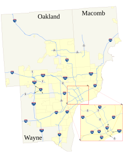
The roads and freeways in metropolitan Detroit comprise the main thoroughfares in the region. The freeways consist of an advanced network of interconnecting freeways which include Interstate highways. The Metro Detroit region's extensive toll-free freeway system, together with its status as a major port city, provide advantages to its location as a global business center. There are no toll roads in Michigan.
Oakland is a city in California.

Waterford Village is an historic community in Waterford Township, Michigan. First settled in 1819, the village is located in the northernmost part of the township along Dixie Highway, on the southeast shore of Van Norman Lake.

