
Saltville is a town in Smyth and Washington counties in the U.S. state of Virginia. The population was 1,824 at the 2020 census. It is part of the Kingsport–Bristol (TN)–Bristol (VA) Metropolitan Statistical Area, which is a component of the Johnson City–Kingsport–Bristol, TN-VA Combined Statistical Area – commonly known as the "Tri-Cities" region.
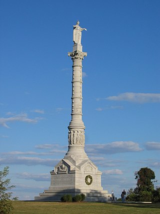
Colonial National Historical Park is a large national historical park located in the Hampton Roads region of Virginia operated by the National Park Service. It protects and interprets several sites relating to the Colony of Virginia and the history of the United States more broadly. These range from the site of the first English settlement at Jamestown, to the battlefields of Yorktown where the British Army was defeated in the American Revolutionary War. Over 3 million people visit the park each year.

Petersburg National Battlefield is a National Park Service unit preserving sites related to the American Civil War Siege of Petersburg (1864–65). The battlefield is near the city of Petersburg, Virginia, and includes outlying components in Hopewell, Prince George County, and Dinwiddie County. Over 140,000 people visit the park annually.

Buildings, sites, districts, and objects in Virginia listed on the National Register of Historic Places:
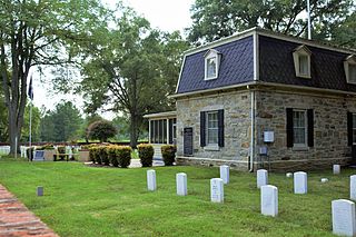
Fort Harrison National Cemetery is a United States National Cemetery located seven miles (11 km) south of the city of Richmond, in Henrico County, Virginia. Administered by the United States Department of Veterans Affairs, It encompasses 1.5 acres (0.61 ha), and as of the end of 2005, had 1,570 interments.
The Jenkins' Ferry Battleground State Park, also known as the Jenkins' Ferry Battlefield, is a battlefield in Grant County, Arkansas. The Arkansas state park commemorates the Battle of Jenkins' Ferry fought on Saturday, April 30, 1864, during the Red River Campaign of the American Civil War.

Sayler's Creek Battlefield, near Farmville, Virginia, was the site of the Battle of Sayler's Creek of the American Civil War. Confederate general Robert E. Lee's army was retreating from the Richmond to the Petersburg line. Here, on April 6, 1865, Union general Philip Sheridan cut off and beat back about a quarter of Lee's depleted army. Eight Confederate generals surrendered, and 7,700 men were lost. Confederate Major General George Washington Custis Lee, eldest son of Robert E. Lee, was forcibly captured on the battlefield by Private David Dunnels White of the 37th Massachusetts Regiment. The battle was the last major engagement of the war in Virginia; Lee's surrender at Appomattox occurred three days later. A portion of the landmarked battlefield area is included in Sailor's Creek Battlefield Historical State Park. The Civil War Trust and its partners have acquired and preserved 885 acres (3.58 km2) of the battlefield in five transactions since 1996.

Longdale Furnace is an unincorporated community located east of Clifton Forge in Alleghany County, Virginia, United States.

This is a list of the National Register of Historic Places listings in Smyth County, Virginia.

Milford Battlefield is situated in Overall, Virginia in Warren County and Page County, Virginia. It was the site of a battle on September 22–24 during the Valley campaigns of 1864 in the American Civil War. The site is located on property now privately owned.

Luke Mountain Historic District is a national historic district located near Covington, Alleghany County, Virginia. The district encompasses 12 contributing buildings, 4 contributing sites, 6 contributing structures, and 1 contributing object on Luke Mountain overlooking the city of Covington. It includes three high style dwellings all built for members of the Luke family, the earliest of which was built in 1919. Other contributing resources include the former farm manager's house; agricultural barns, shelters, greenhouses, and storage buildings; and domestic structures such as swimming pools and garages. Other landscape features include a winding entrance drive, a pair of gateposts, stone-lined drainage ditches, a concrete bridge/culvert over Lindsay Glen Run, a reservoir and private water system, terraced fields, pastureland, formal garden spaces, and walking/hiking paths.
Cool Spring Battlefield is a historic American Civil War battlefield and national historic district located near Berryville, Clarke County, Virginia. It encompasses 17 contributing buildings, 26 contributing sites, and 11 contributing structures. The district includes the terrain and hydrography over which the Battle of Cool Spring, July 16–20, 1864, was fought and which served to shape the tactical progress of the engagement in time and space. The district also includes the archaeological and architectural remnants of plantations, farmsteads, transportation, mining, and industrial centers that were a part of the economically prosperous community over which the conflict was fought. Located in the district is the separately listed Wickliffe Church.

Auburn Battlefield, also known as Coffee Hill Battlefield, is a national historic district and American Civil War battlefield located near Catlett, Fauquier County, Virginia. It encompasses the areas of the two Auburn battles on October 13 and 14, 1863, and includes 18 contributing buildings, 23 contributing sites, and 8 contributing structures. The battles are referred to as the First Battle of Auburn and Second Battle of Auburn.
Unison Historic District is a national historic district located at Unison, near Middleburg, Loudoun County, Virginia. It encompasses 41 contributing buildings and 3 contributing structures in the village of Unison. It is primarily residential, but also includes a church, former school, store, and saddle-maker's shop. The oldest buildings are "Butterland" and "Elton." Other notable buildings include the Thornton Walker House, Mary Phillips House, Henry Evans House, Glatton Folly, and Unison United Methodist Church.

Buckland Historic District is a national historic district located at Buckland, Prince William County, Virginia. It encompasses 30 contributing buildings, 11 contributing sites, and 6 contributing structures in the town of Buckland. The district is centered on a grist mill, Buckland Mill, the third such structure located on the site. Besides the mill, the most significant buildings include an early 19th-century wagon tavern and a small church. For the most part the houses are small, simple, 19th-century dwellings constructed of log, frame or stone; most were intended to serve a commercial as well as a residential purpose. Other contributing resources include the mill race and dam, Cerro Gordo plantation, portions of the Civil War Buckland battlefields, the Kinsley Mill and miller's house, and Buckland Hall.

Thoroughfare Gap Battlefield is a historic American Civil War battlefield located at Thoroughfare Gap, Broad Run, Prince William County, Virginia. It was the site of the Battle of Thoroughfare Gap. The property includes a number of resources present at the time of the battle including the separately listed Beverley Mill, a five-story, coursed-rubble stone building set into the north side of Thoroughfare Gap. Meadowlands, the Chapman's house and the second Upper Mill are clearly visible on the landscape, as well as an important ice pit and a walled cemetery associated with the Chapman family.

New Market Battlefield State Historical Park is a historic American Civil War battlefield and national historic district located near New Market, Shenandoah County, Virginia. The district encompasses the site of the Battle of New Market, a battle fought on May 15, 1864, during Valley Campaigns of 1864. In the middle of the battlefield stands the Bushong House, used by both sides as a hospital during the battle and now the visitor center for the 300-acre park.

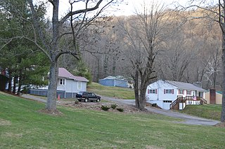
Saltville Historic District is a national historic district located at Saltville, Smyth County, Virginia. The district includes 104 contributing buildings and 3 contributing sites in the central business district and surrounding residential areas of Saltville. It includes a variety of residential and commercial buildings primarily dating from the late-19th to mid-20th centuries. Notable buildings and sites include Well Fields, Saltville Golf Course, Office Building (1850), Mathieson Alkali Office Building (1894), company store (1895), First National Bank of Saltville, St. Paul's Episcopal Church (1896), Gothic Revival style Madam Russell Memorial United Methodist Church, Duplex House (1894), Saltville Post Office (1931), Piggly-Wiggly Store, Saltville Savings Bank (1920), and Saltville Town Hall (1949).
The Preston House, also known as the Palmer House, was a historic home located at Saltville, Smyth County, Virginia. The original section was built about 1795. It was a two-story, gable-roofed, double-pile frame structure covered with beaded weatherboard. It consisted of a two-story, five bay center section flanked by later, and lower, two-story, three bay flanking wings. The house was built by lawyer and politician Francis Preston (1765–1836), whose family owned the salt works. The house was destroyed in 1978.
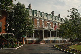
Abingdon Historic District is a national historic district located at Abingdon, Washington County, Virginia. The district encompasses 145 contributing buildings, 2 contributing site, and 13 contributing structures in the town of Abingdon. It includes a variety of residential, commercial, and institutional buildings dating from the late-18th century to the mid-20th century. Notable contributing resources include Sinking Spring Cemetery, William King High School (1913), General Francis Preston House (1832), Martha Washington Inn, Barter Theatre, the Virginia House, Alexander Findlay House (1827), Gabriel Stickley House, Ann Berry House, Washington County Courthouse (1868), Rev. Charles Cummings House, and James Fields House (1857). Located in the district and separately listed are the Abingdon Bank and Dr. William H. Pitts House.


