
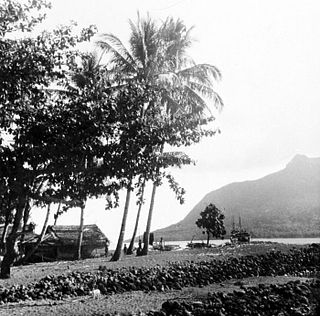
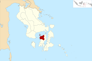
Siau is an island in North Sulawesi, Indonesia, located in the Sangir Archipelago approximately 130 km (81 mi) off the northern tip of Sulawesi in the Celebes Sea. Covering a land area of 160 km2, it is the main island of the Sitaro Islands Regency of North Sulawesi Province.

The Sangihe Islands – Indonesian: Kepulauan Sangihe – are a group of islands that constitute two regencies within the province of North Sulawesi, in northern Indonesia, the Sangihe Islands Regency and the Sitaro Islands Regency. They are located northeast of Sulawesi between the Celebes Sea and the Molucca Sea, roughly halfway between Sulawesi and Mindanao, in the Philippines; the Sangihes form the eastern limit of the Celebes Sea. The islands combine to total 813 square kilometers (314 sq mi), with many of the islands being actively volcanic with fertile soil and mountains.
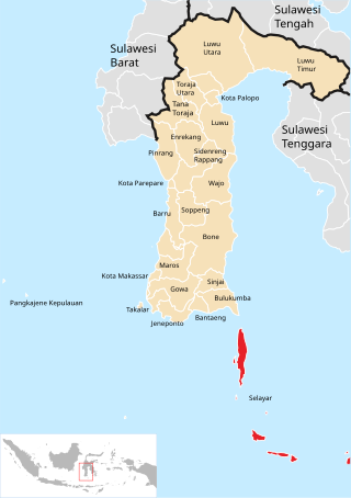
The Selayar Islands Regency is a regency of Indonesia in South Sulawesi province that covers the Selayar Islands, which lie southeast of the southern peninsula of Sulawesi. The archipelago consists of the group's main island, which is surrounded by 41 smaller islands around its coast; further to the southeast lies a widespread group of islands, including the smaller but still substantial islands of Pasimassunggu, Pasimarannu and Pasilambena in the far south, and the huge atoll of Takabonerate. The regency covers an area of 1,357.03 km2, and had a population of 103,596 at the 2000 Census, 122,055 at the Census of 2010 and 137,071 at that of 2020. The official estimate for mid 2023 was 142,100. The administrative centre is the town of Benteng on Selayar Island. The Selayar Straits separate the regency from Sulawesi island.
Yapen Islands Regency is a regency (kabupaten) in Papua Province of eastern Indonesia. It covers an area of 2,432.49 km2 (939.19 sq mi), and had a population of 82,951 at the 2010 Census and 112,676 at the 2020 Census; the official estimate as at mid 2022 was 116,107. It comprises an archipelago which lies in Cenderawasih Bay off the north coast of Western New Guinea.

Pinrang Regency is one of the twenty-one regencies in South Sulawesi Province of Indonesia. Pinrang town in Watang Sawitto District is the administrative capital of Pinrang Regency. The regency is situated in the northwest of the South Sulawesi peninsula, and covers a land area of 1,896.57 km2. It had a population of 351,161 at the 2010 Census and 403,994 at the 2020 Census; the official estimate as at mid 2023 was 417,932.

The Pangkajene and Islands Regency, is a regency of South Sulawesi province of Indonesia. The regency lies primarily on the mainland of Sulawesi's southern peninsula, but also includes the Spermonde Islands off the west coast of that peninsula, as well as other small islands further west and southwest. The principal town lies at Pangkajene on Sulawesi, but there are a series of further small towns like Lejang, Labakkang, Bonto-Bonto and Segeri proceeding northwards from Pangkajene along the Trans-Sulawesi Highway. The total land area is 1,112.29 km2, and the population was 305,737 at the 2010 Census and 345,775 at the 2020 Census; the official population estimate as of mid-2023 was 357,846.

Sinjai Regency is a regency of the South Sulawesi province of Indonesia. The regency, which is separated from the Bone Regency to its north by the River Tangka, covers an area of 819.96 km2. It had a population of 228,936 at the 2010 census and 259,478 at the 2020 census. The official estimate of population as of mid-2024 was 273,559. It includes the Nine Islands in the Gulf of Bone off the east coast of the southern peninsula of Sulawesi; this archipelago forms an administrative district within the regency. The regency's principal town lies at Sinjai, a port situated on the east coast of that peninsula.

Takalar Regency is a regency of South Sulawesi Province, Indonesia. It covers an area of 566.51 km2 and had a population of 269,603 at the 2010 census and 300,853 at the 2020 census; the official estimate for mid 2023 was 326,044. The entire regency lies within the official metropolitan area of the city of Makassar. The principal towns are at Galesong and Takalar, but the administrative centre is at Pattallassang.

South Konawe Regency is a regency of Southeast Sulawesi Province, Indonesia. The regency was created on 25 February 2003 from what had been the southern districts of Konawe Regency. It covers an area of 4,237.74 km2 and had a population of 264,587 at the 2010 Census and of 308,524 at the 2020 Census; the official estimate as at mid 2023 was 322,946 - comprising 165,487 males and 157,459 females.< The administrative centre is in the town of Andoolo.

The Banggai Archipelago is a group of islands located at the far eastern end of Central Sulawesi, Indonesia. It makes up a regency (kabupaten) of Central Sulawesi Province of Indonesia, created on 4 October 1999 by splitting the existing Banggai Regency into a residual Banggai Regency situated on the mainland of Sulawesi and a new Banggai Islands Regency then comprising the entire archipelago. On 14 December 2012 a splitting of the Banggai Islands archipelago took place with the removal of the more southerly seven districts from the 13-year-old regency to form a separate Banggai Laut Regency.
Tolitoli Regency is a regency of Central Sulawesi Province of Indonesia. It was previously part of a larger Buol Tolitoli Regency, but this was split into two on 4 October 1999 after rapid decentralization of the Indonesian government. The present Tolitoli Regency covers an area of 3,701.54 km2 and had a population of 211,296 at the 2010 Census and 225,154 at the 2020 Census; the official estimate as at mid 2023 was 231,711, comprising 118,180 male and 113,530 female inhabitants. Its regency seat is located at the town of Tolitoli, which is a port town and where the regency's population is concentrated.

North Minahasa Regency is a regency in North Sulawesi, Indonesia. Its capital is Airmadidi. It was originally part of the Minahasa Regency until it was split off and established as a separate regency on 20 November 2003. It covers an area of 1,059.24 km2, and had a population of 188,904 at the 2010 Census; this had risen to 224,993 at the 2020 Census, and the official estimate as at mid 2023 was 231,791. The Regency includes the offshore islands of Bangka and Talisei to the north of Sulawesi, and Mantenang and Naeng Besar to the northwest.

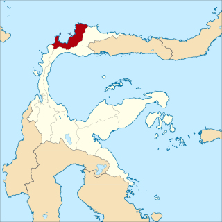
The Sangihe Islands Regency is a regency of North Sulawesi Province, Indonesia. It comprises a group of islands situated to the North of Sulawesi. It covers a land area of 736.98 km2, and had a population of 126,100 at the 2010 census and 139,262 at the 2020 census; the official estimate as at mid 2023 was 140,614. The principal island is also named Sangihe, on which lies the main town of Tahuna. Minor island groups within the Regency include the Marore group considerably to the north of Sangihe Island, the Tatoareng group to the south, and the Nusa Tabukan group off the northeast coast of Sangihe Island. It borders the Philippines in the north, making it one of Indonesia's border regions.

South Minahasa Regency is a regency in North Sulawesi, Indonesia. Its capital is the town of Amurang. It was originally part of the Minahasa Regency until it was established as a separate regency on 25 February 2003. In turn, nearly four years later, a new Southeast Minahasa Regency was established as a separate regency from part of the South Minahasa Regency on 2 January 2007. The residual Regency now covers an area of 1,456.74 km2, and had a population of 195,553 at the 2010 Census; this had risen to 236,463 at the 2020 Census; the official estimate as at mid 2023 was 244,590.

Southeast Minahasa Regency is a regency in North Sulawesi, Indonesia. It covers a land area of 730.63 km2, and had a population of 100,443 at the 2010 Census; this had risen to 116,323 at the 2020 Census, and the official estimate as at mid 2023 was 118,946. It was established as a separate regency from the south-eastern part of the South Minahasa Regency on 2 January 2007. Its administrative centre is at the town of Ratahan.
The Talaud Islands Regency is a regency of North Sulawesi province, Indonesia. The Talaud Islands form an archipelago situated to the northeast of the Minahasa Peninsula, with a land area of 1,251.02 km2. It had a population of 83,434 at the 2010 Census, increasing to 94,521 at the 2020 Census; the official estimate as of mid-2023 was 97,312.
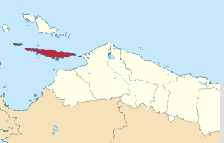
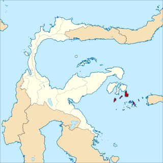
Tagulandang is one of the Sangihe Islands, situated off the northern tip of Sulawesi, Indonesia. It forms three districts in the Sitaro Islands Regency of North Sulawesi province. It is located between the Celebes and Molucca Seas, and is separated from the Ruang stratovolcano by a narrow sea channel. The inhabitants speak Sangirese, and the 2010 census recorded a population of 19,795, while the 2020 Census revealed a population of 22,296 and the official estimate as at mid 2023 was 22,634. The above figures include the area and population of the offshore island of Pulau Ruang, the fourth largest island in the Regency, which lies to the southwest of Tagulandang and contains the active Ruang stratovolcano.
Banggai Sea Regency is a regency in the province of Central Sulawesi, Indonesia. The regency was established on 14 December 2012, partitioned from the Banggai Islands Regency. It comprises the southern part of the Banggai Islands archipelago, including the main island of Banggai itself, the islands of Labobo and Bangkurung to the southwest of Banggai Island, and the numerous small Bokan Islands to the southeast; it does not include the larger island of Peleng to the north which forms the Banggai Islands Regency. The new Banggai Sea Regency covers a land area of 725.67 km2, and the districts now comprising the new Regency had a population of 62,183 at the 2010 Census and 70,435 at the 2020 Census; the official population estimate at mid-2023 was 73,100.
West Muna Regency is a new regency of Southeast Sulawesi Province of Indonesia,and is situated in the northwest corner of Muna Island and smaller ilsands of its coast. It was established under Act No.14 of 2014, dated 23 July 2014 by separation from the Muna Regency. It covers an area of 906.28 km2, and the districts comprising it had a population of 71,632 at the 2010 Census; the 2020 Census resulted in a population of 84,590, and the official estimate as at mid 2022 was 85,706, comprising 42,242 males and 43,464 females. The administrative centre lies at Laworo in the Tiworo Islands District.

Central Buton Regency is a new regency of Southeast Sulawesi established by separation from Buton Regency under Act No.15 of 2014, dated 23 July 2014. It covers an area of 837.16 km2 comprising the southern parts of Muna Island and Kabaena Island, together with several small offshore islands adjacent to these two main islands, but with no territory located on Buton Island. It had a population of 86,112 at the 2010 Census and 114,773 at the 2020 Census; the official estimate as at mid 2023 was 121,369. The administrative centre lies at Labungkari in Lakudo District.


