Special routes of U.S. Route 101 | |
|---|---|
| Highway system | |

A total of fifteen special routes of U.S. Route 101 exist.
Special routes of U.S. Route 101 | |
|---|---|
| Highway system | |
A total of fifteen special routes of U.S. Route 101 exist.
U.S. Route 101 Alternate | |
|---|---|
| Location | Los Angeles, California |
| Existed | Mid-1930s–1964 |
Present SR 1 in the Los Angeles area was U.S. Route 101 Alternate from the mid-1930s to 1964.
U.S. Route 101 Bypass | |
|---|---|
| Location | Los Angeles – Anaheim, California |
| Existed | Early-1940s–Mid-1950s |
The precursor to the Santa Ana Freeway between Los Angeles and Anaheim was U.S. Route 101 Bypass from the early 1940s to the mid-1950s, when it became part of US 101. Old US 101 there is now partially SR 72.
U.S. Route 101 Business | |
|---|---|
| Location | Ventura, California |
US 101 Business in Ventura, California is a business loop that follows the former U.S. 101 alignment before the construction of the Ventura Freeway. The route runs along the entirety of Thompson Boulevard and portions of Main Street and Garden Street.
U.S. Route 101 Bypass | |
|---|---|
| Location | El Camino Real, California |
| Existed | 1938–1964 |
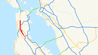
The Bayshore Highway between San Jose and San Francisco was designated as part of US 101 in 1936, replacing El Camino Real (which became US 101 Alternate). [1] [2] At the urging of local businesses and groups, a proposal was submitted to AASHO to move US 101 back to El Camino Real, which was approved in 1938 alongside the creation of US 101 Bypass for the Bayshore Highway. [3] [4] Other proposals included signing El Camino Real as US 101 Scenic. [5]
The Bayshore Freeway was constructed to replace the original highway between 1947 and 1962. [6] US 101 was later rerouted onto the Bayshore Freeway during the 1964 renumbering and replaced US 101 Bypass entirely. Until then, US 101 used SR 82 (El Camino Real) and I-280.
U.S. Route 101 Business | |
|---|---|
| Location | Rio Dell |
US 101 Business, called Wildwood Avenue, is a business loop of US 101 through Rio Dell. Its southernmost section between US 101 near Scotia to the north end of the Eel River Bridge is legally defined as an unsigned California State Route 283.
U.S. Route 101 Business | |
|---|---|
| Location | Fortuna |
US 101 Business, called Main Street and Fortuna Blvd in its entirety, is a business loop of US 101 through Fortuna.
U.S. Route 101 Business | |
|---|---|
| Location | McKinleyville |
US 101 Business, called Central Ave its entirety, is a business loop of US 101 through McKinleyville.
U.S. Highway 101 Business | |
|---|---|
| Location | Astoria–Warrenton, Oregon |
| Length | 7.40 mi [7] [8] (11.91 km) |
| Existed | 1965–present |
U.S. Route 101 Business is a business loop of US 101 that travels from Astoria to Warrenton. It is a former alignment of US 101, bypassed in 1964 when a new bridge opened across Youngs Bay; the business designation for the old route was approved by AASHO in 1965. [9] The Oregon State Highway Commission originally requested the designation of U.S. Route 101 Alternate, which was rejected. [10]
Major intersections
The entire route is in Clatsop County.
| Location | mi [7] [8] | km | Destinations | Notes | |
|---|---|---|---|---|---|
| Warrenton | 1.27 | 2.04 | |||
| Lewis and Clark River | 4.67– 4.83 | 7.52– 7.77 | Lewis and Clark River Bridge | ||
| Youngs Bay | 6.75– 7.08 | 10.86– 11.39 | Old Youngs Bay Bridge | ||
| Astoria | 7.25 1.42 | 11.67 2.29 | South end of OR 202 overlap | ||
| 0.18 | 0.29 | North end of OR 202 overlap | |||
1.000 mi = 1.609 km; 1.000 km = 0.621 mi
| |||||
U.S. Route 101 Alternate | |
|---|---|
| Location | Long Beach, Washington |
| Existed | 1931–present |
U.S. Route 101 Alternate is an alternate route of U.S. Route 101 that bypasses the towns of Long Beach and Ilwaco in southwestern Washington.

U.S. Route 101, or U.S. Highway 101 (US 101), is a north–south United States Numbered Highway that traverses the states of California, Oregon, and Washington, on the West Coast of the United States. It travels for over 1,500 miles (2,400 km), primarily along the Pacific Ocean, and is also known by various names, including El Camino Real in parts of California, the Oregon Coast Highway, and the Olympic Highway in Washington. Despite its three-digit number, normally used for spur routes, US 101 is a classified as a major route in the United States Numbered Highway System.

U.S. Route 80 or U.S. Highway 80 (US 80) is a major east–west United States Numbered Highway in the Southern United States, much of which was once part of the early auto trail known as the Dixie Overland Highway. As the "0" in the route number indicates, it was originally a cross-country route, from the Pacific Ocean to the Atlantic Ocean. Its original western terminus was at Historic US 101 in San Diego, California. However, the entire segment west of Dallas, Texas, has been decommissioned in favor of various Interstate Highways and state highways. Currently, the highway's western terminus is at an interchange with Interstate 30 (I-30) on the Dallas–Mesquite, Texas city line. Its eastern terminus is in Tybee Island, Georgia near the Atlantic Ocean. Between Jonesville, Texas and Kewanee, Mississippi, US 80 runs parallel to or concurrently with Interstate 20. It also currently runs through Dallas, Texas; Shreveport, Louisiana; Jackson, Mississippi; Montgomery, Alabama; Columbus, Georgia; Macon, Georgia; and Savannah, Georgia.
The state highway system of the U.S. state of California is a network of highways that are owned and maintained by the California Department of Transportation (Caltrans).

The Santa Ana Freeway is one of the principal freeways in Southern California, connecting Los Angeles and its southeastern suburbs including the freeway's namesake, the city of Santa Ana. The freeway begins at its junction with the San Diego Freeway, called the El Toro Y, in Irvine, signed as I-5. From there, it generally goes southeast to northwest to the East Los Angeles Interchange, where it takes the designation of U.S. Route 101 (US 101). It then proceeds 2.95 miles (4.75 km) northwest to the Four Level Interchange in downtown Los Angeles. Formerly, the entirety of the route was marked as US 101 until the 1964 highway renumbering, which truncated US 101 to the East Los Angeles Interchange and designated the rest of the freeway as I-5.

The Bayshore Freeway is a part of U.S. Route 101 in the San Francisco Bay Area of the U.S. state of California. It runs along the west shore of the San Francisco Bay, connecting San Jose with San Francisco. Within the city of San Francisco, the freeway is also known as James Lick Freeway, named after the California philanthropist. The road was originally built as a surface road, the Bayshore Highway, and later upgraded to freeway standards. Before 1964, it was mostly marked as U.S. Route 101 Bypass, with US 101 using the present State Route 82.
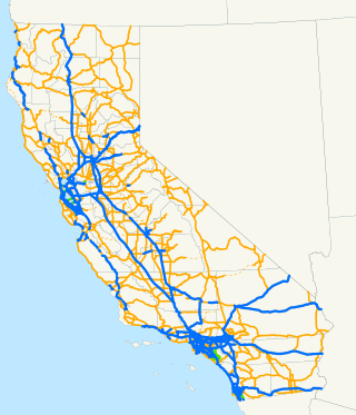
State Route 58 is a major east-west state highway in the U.S. state of California that runs across the Coast Ranges, the southern San Joaquin Valley, the Tehachapi Mountains, which border the southern Sierra Nevada, and the Mojave Desert. It runs between U.S. Route 101 near Santa Margarita and Interstate 15 in Barstow. It has junctions with Interstate 5 near Buttonwillow, State Route 99 in Bakersfield, State Route 202 in Tehachapi, State Route 14 near Mojave, and U.S. Route 395 at Kramer Junction. SR 58 also provides access to Edwards Air Force Base. At various points it is known as the Calf Canyon Highway, Carrisa Highway, Bakersfield-McKittrick Highway, Rosa Parks Highway, Rosedale Highway, Barstow-Bakersfield Highway, Bakersfield Tehachapi Highway, Kern County Korean War Veterans Memorial Highway, and Mojave-Barstow Highway.

State Route 87, known as the Guadalupe Freeway or referred to by the locals as Highway 87, is a north–south state highway in San Jose, California, United States. Before being upgraded to a freeway, it was Guadalupe Parkway.

State Route 82 is a state highway in the U.S. state of California that runs from Interstate 880 (I-880) in San Jose to I-280 in San Francisco following the San Francisco Peninsula. It is the spinal arterial road of the peninsula and runs parallel to the nearby Caltrain line along much of the route. For much of its length, the highway is named El Camino Real and formed part of the historic El Camino Real mission trail. It passes through and near the historic downtowns of many Peninsula cities, including Burlingame, San Mateo, Redwood City, Menlo Park, Palo Alto, Mountain View, and Sunnyvale, and through some of the most walkable and transit-oriented neighborhoods in the region.
U.S. Route 158 (US 158) is an east–west United States highway that runs for 350 miles (560 km) from Mocksville to Whalebone Junction in Nags Head, entirely in the state of North Carolina. It is also a critical route that connects the cities of Winston-Salem, Summerfield, and Reidsville with one another.

State Route 41 is a state highway in the U.S. State of California, connecting the Central Coast with the San Joaquin Valley and the Sierra Nevada. Its southern terminus is at the Cabrillo Highway in Morro Bay, and its northern terminus is at SR 140 in Yosemite National Park. It has been constructed as an expressway from near SR 198 in Lemoore north to the south part of Fresno, where the Yosemite Freeway begins, passing along the east side of downtown and extending north into Madera County.
U.S. Route 101 (US 101) is a major north–south United States Numbered Highway, stretching from Los Angeles, California, to Tumwater, Washington. The California portion of US 101 is one of the last remaining and longest U.S. Routes still active in the state, and the longest highway of any kind in California. US 101 was also one of the original national routes established in 1926. Significant portions of US 101 between the Los Angeles area and the San Francisco Bay Area follow El Camino Real, the commemorative route connecting the former Alta California's 21 missions.
Interstate 80 (I-80) is a transcontinental Interstate Highway in the United States, stretching from San Francisco, California, to Teaneck, New Jersey. The segment of I-80 in California runs east from San Francisco across the San Francisco–Oakland Bay Bridge to Oakland, where it turns north and crosses the Carquinez Bridge before turning back northeast through the Sacramento Valley. I-80 then traverses the Sierra Nevada, cresting at Donner Summit, before crossing into the state of Nevada within the Truckee River Canyon. The speed limit is at most 65 mph (105 km/h) along the entire route instead of the state's maximum of 70 mph (110 km/h) as most of the route is in either urban areas or mountainous terrain. I-80 has portions designated as the Eastshore Freeway and Alan S. Hart Freeway.
Sierra Highway or El Camino Sierra is a road in Southern California, United States. El Camino Sierra refers to the full length of a trail formed in the 19th century, rebuilt as highways in the early 20th century, that ran from Los Angeles to Lake Tahoe following parts of modern State Route 14, U.S. Route 395 and State Route 89. Two portions of this road are currently signed as Sierra Highway. The first is an old alignment of SR 14/U.S. Route 6 from Los Angeles to Mojave. This road is also signed with the unusual designation of State Route 14U through the city of Santa Clarita. The second part signed as Sierra Highway is a portion of US 395 in Bishop.

U.S. Route 50 (US 50) is a transcontinental United States Numbered Highway, stretching from West Sacramento, California, in the west to Ocean City, Maryland, in the east. The California portion of US 50 runs east from Interstate 80 (I-80) in West Sacramento to the Nevada state line in South Lake Tahoe. A portion in Sacramento also has the unsigned designation of Interstate 305. The western half of the highway in California is a four-or-more-lane divided highway, mostly built to freeway standards, and known as the El Dorado Freeway outside of downtown Sacramento. US 50 continues as an undivided highway with one eastbound lane and two westbound lanes until the route reaches the canyon of the South Fork American River at Riverton. The remainder of the highway, which climbs along and out of the canyon, then over the Sierra Nevada at Echo Summit and into the Lake Tahoe Basin, is primarily a two-lane road.

There have been 22 special routes of U.S. Route 66.
Junipero Serra Boulevard is a major boulevard in and south of San Francisco named after Franciscan friar Junipero Serra. Within the city, it forms part of the route of State Route 1, the shortest connection between Interstate 280 and the Golden Gate Bridge. The remainder, in San Mateo County, was bypassed or replaced by I-280, the Junipero Serra Freeway. The boulevard was one of several new roads built along the San Francisco Peninsula before the age of freeways, and became a state highway known as Route 237 in 1956, receiving the State Route 117 designation in the 1964 renumbering, only to be deleted from the state highway system the next year. Two other regional highways—Bayshore Highway and Skyline Boulevard—were also upgraded into or bypassed by freeways.

U.S. Route 80 (US 80) was a U.S. highway in California that continued east across the country to Georgia. The western terminus of US 80 was in San Diego, California, and it continued east through the city on several different alignments through the years. The highway went through the Cuyamaca Mountains, encountering many switchbacks, before descending to El Centro. After passing through the sand dunes, the highway crossed the Colorado River into Yuma, Arizona.

Several special routes of U.S. Route 40 exist. In order from west to east they are as follows.

Several special routes of U.S. Route 29 exist. In order from south to north they are as follows.

Monterey Road is a major Silicon Valley thoroughfare that runs from Gilroy north to San Jose, California, in Santa Clara County. It follows the historic route of El Camino Real and is an old alignment of U.S. Route 101.