West Park Terrace, Los Angeles

Last updated
West Park Terrace
West Park Terrace Neighborhood Sign.jpg
West Park Terrace neighborhood sign
located on Van Ness Avenue
and Manchester Boulevard
Location map Southern Los Angeles.png
Red pog.svg
West Park Terrace
Location within South Los Angeles
Coordinates: 33°57′31″N118°18′01″W / 33.9585314°N 118.3004003°W / 33.9585314; -118.3004003
Country Flag of the United States.svg  United States
State Flag of California.svg  California
County Flag of Los Angeles County, California.svg Los Angeles
CityFlag of Los Angeles, California.svg  Los Angeles
Time zone Pacific
Area code 323

West Park Terrace is a neighborhood in South Los Angeles. The 2009 Mapping L.A. project of the Los Angeles Times gave the same area a different name: Grammercy Park.

Contents

History

Beginning in 2000, the Eighth District Empowerment Congress began working on the "Naming Neighborhoods Project" to identify and name the communities with the neighborhood council area. The first focus group was held at Hebrew Union College in June 2000. Through research, a meeting with an urban historian, and numerous community meetings, the Empowerment Congress ultimately outlined sixteen unique neighborhoods, including the neighborhood of West Park Terrace. The names were submitted to City Council in October 2001 and approved in February 2002. [1]

In 2009, the Mapping L.A. project of the Los Angeles Times gave the same area a different name: Grammercy Park. In 2021, the Southwest Neighborhood Council stated that the two different names caused confusion and asked residents which name they preferred. [2] By 2022, however, the Times was using the city designation of West Park Terrace. [3]

Geography

The 1.13-square-mile West Park Terrace neighborhood is bounded by Manchester Boulevard on the north (from Van Ness Avenue to Vermont Avenue), Vermont Avenue on the east (from Manchester Avenue to the City of Los Angeles boundary), City of Los Angeles boundary on the south (from Vermont Avenue to Van Ness Avenue) and Van Ness Avenue (from Manchester Avenue to the City of Los Angeles boundary).

At that time, the Department of Transportation was directed to install neighborhood signs at the following locations: Vermont Avenue at Manchester Avenue, Manchester Avenue at South Van Ness Avenue and Van Ness Avenue at West 89th Street. [1]

According to Mapping L.A., the West Park Terrace neighborhood is bounded by Manchester Boulevard on the north, Normandie Avenue and the Los Angeles city line on the east, and the Los Angeles city border on the south and west. [4] [5]

Population

2000

A total of 10,047 people lived in the neighborhood's 1.13 square miles, according to the 2000 U.S. census—averaging 8,859 people per square mile, about an average population density in both the city and the county. In 2008 the city estimated its population had grown to 11,173. [4]

The median age was 36, considered old for the city but about average for the county, and the percentages of residents aged 50 and older was among the county's highest. [4]

Within the neighborhood, African Americans made up 86.4% of the population—the highest percentage among Los Angeles County neighborhoods or cities—and Latinos made up 11.5% of the population. Other ethnicities were white, 0.8%; Asian, 0.4%; and other, 0.9%. Mexico and Jamaica were the most common places of birth for the 9.3% of the residents who were born abroad, a low percentage of foreign-born when compared with the city or county as a whole. [4]

Jamaican and Unspecified African were the most common ancestries. Mexico and Jamaica were the most common foreign places of birth. [4]

2008

The median household income in 2008 dollars was $57,983, considered average for both the city and county. The percentage of households earning $40,000 to $60,000 was high, compared to the county at large. The average household size of 2.8 people was about average. Homeowners occupied 70.4% of the housing units, and renters occupied the rest. [4]

The percentages of divorced and widowed people were among the county's highest, and there were 562 families headed by single parents, or 21.9%, a rate that was among the county's highest. [4]

There were 939 veterans, or 13.1% of the population, considered high compared with the city and the county overall. [4]

Residents aged 25 and older holding a four-year degree amounted to 14.9% of the population, an average percentage for both the city and the county. The percentage of residents of that age having some college education was considered high. [4]

Education

The following LAUSD public schools within the boundaries of West Park Terrace are: [6]

Recreation and parks

Development

In 2020, CVS announced it would build a new ground-up location in West Park Terrace. [9]

See also

Related Research Articles

<span class="mw-page-title-main">Athens, California</span> Unincorporated community in California, United States

Athens is an unincorporated community in the South Los Angeles region of Los Angeles County, California, numbering 9,101 people in the 2000 census. It is the home site of Los Angeles Southwest College.

<span class="mw-page-title-main">Larchmont, Los Angeles</span> Neighborhood of Los Angeles in California, United States

Larchmont is a half-square-mile neighborhood in the central region of the City of Los Angeles, California. It has three schools and one small park. It has been the site of early and recent motion picture shoots.

<span class="mw-page-title-main">East Hollywood, Los Angeles</span> Neighborhood of Los Angeles in California, United States

East Hollywood is a densely populated neighborhood of 78,000+ residents that is part of the Hollywood area of the central region of Los Angeles, California. It is notable for being the site of Los Angeles City College, Barnsdall Park, and a hospital district. There are seven public and five private schools, a Los Angeles Public Library branch, and three hospitals. Almost two-thirds of the people living there were born outside the United States, and 90% were renters. In 2000, the neighborhood had high percentages of never-married people and single parents.

<span class="mw-page-title-main">South Park, Los Angeles</span> Neighborhood of Los Angeles in California, United States

South Park is a 1.41 square miles (3.65 km2) neighborhood within the South Los Angeles region of Los Angeles, California.

<span class="mw-page-title-main">Harbor Gateway, Los Angeles</span> Neighborhood of Los Angeles in California, United States

The Harbor Gateway is a 5.14-square-mile residential and industrial area (13.3 km2) in the South Bay and Los Angeles Harbor Region, in the southern part of the city. The neighborhood is narrow and long, running along a north-south axis. Its unusual shape has given it the alternative name of "the Shoestring Strip". The northern limit of the neighborhood is Imperial Highway, a city street just north of I-105.

<span class="mw-page-title-main">Vermont Square, Los Angeles</span> Neighborhood of Los Angeles in California, United States

Vermont Square is a neighborhood in Los Angeles, California, within the South Los Angeles region. The Vermont Square Branch library, a designated Historic–Cultural Monument, is located in the community.

<span class="mw-page-title-main">Hyde Park, Los Angeles</span> Neighborhood of Los Angeles in California, United States

Hyde Park is a neighborhood in the South region of Los Angeles, California. Formerly a separate city, it was consolidated with Los Angeles in 1923.

<span class="mw-page-title-main">University Park, Los Angeles</span> Neighborhood of Los Angeles in California, United States

University Park is a 1.17 square miles (3.0 km2) neighborhood in the South Los Angeles region of Los Angeles, California. It is the home of the University of Southern California (USC), Mount St. Mary's College and Hebrew Union College. Additionally, the neighborhood is the home of the historic Shrine Auditorium.

<span class="mw-page-title-main">Vermont Knolls, Los Angeles</span> Neighborhood of Los Angeles in California, United States

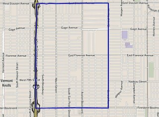
Vermont Knolls is a neighborhood in Los Angeles, California, within the South Los Angeles region.

<span class="mw-page-title-main">Chesterfield Square, Los Angeles</span> Neighborhood of Los Angeles in California, United States

Chesterfield Square is a 0.63-square-mile neighborhood in Los Angeles, California, located within the South Los Angeles region. It contains its namesake park, along with the Van Ness Recreation Center.

<span class="mw-page-title-main">Historic South Central Los Angeles</span> Neighborhood of Los Angeles in California, United States

Historic South Central Los Angeles is a 2.25-square-mile neighborhood in Los Angeles, California, within the South Los Angeles region. It is the site of the Bob Hope Patriotic Hall.

<span class="mw-page-title-main">Manchester Square, Los Angeles</span> Neighborhood of Los Angeles in California, United States

Manchester Square is a neighborhood in Los Angeles, California, within the South Los Angeles region.

<span class="mw-page-title-main">Central-Alameda, Los Angeles</span> Neighborhood of Los Angeles in California, United States

Central-Alameda is a 2.18 square miles (5.65 km2) square mile neighborhood within the South Los Angeles region of Los Angeles, California.

<span class="mw-page-title-main">Florence, Los Angeles</span> Neighborhood of Los Angeles in California, United States

Florence is a neighborhood in Los Angeles, California. The neighborhood, part of the South Los Angeles region, is home to over 46,000 residents.

<span class="mw-page-title-main">Green Meadows, Los Angeles</span> Neighborhood of Los Angeles in California, United States

Green Meadows is a neighborhood in South Los Angeles, California, with a population of more than thirty thousand people. Green Meadows is within the South Los Angeles Community Plan area and is the home of Locke College Preparatory Academy.

<span class="mw-page-title-main">Harvard Park, Los Angeles</span> Neighborhood of Los Angeles in California, United States of America

Harvard Park is a 0.64-square-mile neighborhood in the South Los Angeles region of Los Angeles, California.

Vermont-Slauson is a 1.44-square-mile neighborhood within the South Los Angeles region of Los Angeles, California.

<span class="mw-page-title-main">Adams-Normandie, Los Angeles</span> Neighborhood in Los Angeles, California, United States

Adams-Normandie is a Historic Preservation Overlay Zone (HPOZ) in South Los Angeles, California.

<span class="mw-page-title-main">Exposition Park, Los Angeles</span> Neighborhood in California, US

Exposition Park is a neighborhood in the south region of Los Angeles, California. It is home to Exposition Park, which includes the Los Angeles Memorial Coliseum, BMO Stadium, Exposition Rose Garden and three museums: the California African American Museum, the California Science Center and the Natural History Museum of Los Angeles County. It is also home to a Science Center Academy.

<span class="mw-page-title-main">Vermont Vista, Los Angeles</span> Neighborhood of Los Angeles in California, United States

Vermont Vista is a neighborhood in Los Angeles, California, within the South Los Angeles area.

References

  1. 1 2 "Council File 01-1874" (PDF). No. 16. City of Los Angeles. January 2005. Retrieved 31 August 2020.
  2. "Gramercy Park or West Park Terrace?". southwestnc.org. Retrieved 1 March 2023. The community located between Manchester Blvd and 108th St., and Van Ness Ave. and Normandie Ave. is known by two names, Gramercy Park or West Park Terrace.
  3. Campa, Andrew (February 12, 2022). "For street vendors, the Super Bowl could mean a bonanza". Los Angeles Times . Retrieved 10 March 2023. At a gas station in the West Park Terrace neighborhood, which borders Inglewood...
  4. 1 2 3 4 5 6 7 8 9 "Exposition Park," Mapping L.A., Los Angeles Times
  5. "South Los Angeles," Mapping L.A., Los Angeles Times
  6. [ dead link ] "Gramercy Park Schools," Mapping L.A., Los Angeles Times
  7. Saint Andrews Recreation Center Los Angeles City Department of Recreation and Parks
  8. 1 2 Jesse Owens Community Regional Park Los Angeles County Department of Parks and Recreation
  9. Spivak, Caleb (March 11, 2020). "Ground-Up CVS Planned In Parking Lot of South LA Ralphs". What Now Los Angeles. Retrieved 10 March 2023. CVS Pharmacy has plans to build a new ground-up location in South Los Angeles' West Park Terrace neighborhood.