Arcadia, Florida

Last updated

Arcadia, Florida
City of Arcadia
Arcadia Hist Dist downtown Oak Street west01.jpg
Arcadia City Seal.png
DeSoto County Florida Incorporated and Unincorporated areas Arcadia Highlighted 1201750.svg
Location of Arcadia in DeSoto County, Florida....
Coordinates: 27°12′54″N81°51′32″W / 27.215°N 81.859°W / 27.215; -81.859
Country United States of America
State Florida
County DeSoto
Incorporated 1886
Named for Arcadia Albritton
Government
  Type Mayor-Council
   Mayor Robert W. Heine Jr.
   Deputy Mayor Keith Keene
   Council Members Mike Hall, Amber Collins, and Judy Wertz-Strickland
   City Administrator Terry Stewart
   City Clerk Penny Delaney
Area
[1]
  Total4.43 sq mi (11.48 km2)
  Land4.43 sq mi (11.47 km2)
  Water0.01 sq mi (0.02 km2)
Elevation
60 ft (20 m)
Population
 (2020)
  Total7,420
  Density1,675.70/sq mi (647.01/km2)
Time zone UTC-5 (EST)
  Summer (DST) UTC-4 (EDT)
ZIP codes
34265, 34266, 34269
Area code 863
FIPS code 12-01750
Website www.arcadia-fl.gov

Arcadia is a city and county seat of DeSoto County, Florida, United States. Arcadia's Historic District is listed on the National Register of Historic Places. Its population was 7,420 as of the 2020 census, down from 7,637 at the 2010 census. It is the principal city of the Arcadia, Florida Micropolitan Statistical Area.

Contents

History

According to The Atlas of Florida, "The Rev. James Madison ("Boss") Hendry (1839–1922) named the town in honor of Arcadia Albritton (1861–1932), a daughter of Thomas H. and Fannie (Waldron) Albritton, pioneer settlers. Arcadia had baked him a cake for his birthday, and he appreciated it so much that he named the city after her." [2]

First National Bank of Arcadia pictured in this 1905 postcard Arcadia1905.jpg
First National Bank of Arcadia pictured in this 1905 postcard
Presbyterian Church pictured in this 1907 postcard Arcadia1907.jpg
Presbyterian Church pictured in this 1907 postcard

In 1886, transportation improved in Arcadia when the Florida Southern Railway (later the Atlantic Coast Line Railroad) was built through Arcadia on its way from Bartow to Punta Gorda. The railway caused Arcadia to grow significantly, which led to it becoming incorporated a year later. [3] A second railroad line, the Charlotte Harbor and Northern Railway (later the Seaboard Air Line Railroad), was built through Arcadia from 1907 to 1910 on its way from Mulberry to Boca Grande. Both lines have since been consolidated into a single line by CSX with the Seaboard line surviving north of Arcadia and the Atlantic Coast Line surviving to the south. Arcadia was also served by the short-lived East and West Coast Railway, which connected Arcadia with Bradenton from 1915 to 1934. [4]

During the late 19th century Arcadia was the county seat of what would become many counties. In 1921, legislation enacted called for Arcadia to remain the county seat of DeSoto County and resulted in the creation of the present-day counties of Charlotte, Hardee, Glades and Highlands. Prior to this breakup, Arcadia's population had grown considerably, with over 1,000 permanent residents and 3,000 sq mi (7,800 km2) for ranching.

On Thanksgiving Day in 1905, the town was destroyed by a fire that originated from a midtown livery stable. The fire was exacerbated because the town did not have a working water system or fire department. The estimated monetary damage was $250,000, but no loss of life occurred. Much of the business district was not spared. The town recovered only years later.

Oak Street is the "main street" in Arcadia. The downtown is far more elaborate than neighboring counties' downtown areas, as Arcadia is older and was their county seat prior to the formation of their present counties. Arcadia is also home to many early 20th-century homes, houses of worship, and several historic public buildings.

From 1917 to 1922, Arcadia was the home of Carlstrom Field, a grass airfield of the U.S. Army Air Service named for deceased aviation pioneer Victor Carlstrom. Carlstrom Field was used for pilot training both during and after World War I. In May 1941, the site again became an airfield for military primary flight training, operated by the Embry–Riddle Aeronautical Institute (now Embry–Riddle Aeronautical University). Carlstrom Field, one of several satellite fields in the Fort Myers area, also trained pilots for the Royal Air Force until its closing in 1945.

Arcadia's historic buildings include the Johnson-Smith House, William Oswell Ralls House, and Micajah T. Singleton House. Also, around 3,400 acres, which includes the downtown area, are part of the Arcadia Historic District.

After three Arcadia children, the Ray brothers, were diagnosed with HIV in 1986, school officials refused to let them attend school. The Ray family won a $1.1 million judgement against the county school system, but were forced to leave Arcadia after their home was burned down in 1987. [5]

Hurricane Charley and the 21st century

In 2004, Arcadia was heavily damaged by Hurricane Charley, during which the eye went over the city, with winds measured up to 109 mph (49 m/s) at 5:27 pm. The winds were suspected to be stronger outside the city, but cannot be proven due to the lack of equipment outside the city. The city's only shelter, the Turner Agri Civic Center, was a shelter made to withstand winds over 100 mph (45 m/s), but it collapsed during the storm. Everyone evacuated into the hallways and the kitchen of the Turner Center prior to the collapse. [6] The people in the Turner Agri Civic Center were evacuated to DeSoto High School, but soon, part of its roof collapsed. In the center of the town, the Old Opera House's roof was peeled off, causing severe water damage. The hurricane severely damaged downtown, especially businesses on Oak Street and Polk Street. Eventually, the Red Cross shelter was forced to evacuate due to the collapsing of the building. The city water tower crumpled along Florida State Road 70 and was never replaced after the hurricane. The city's only hospital was heavily damaged, with 35 windows shattering. Part of the roof peeled back, which exposed equipment and patients to the wind-driven rain. This caused an estimated $2.3 million in damages to the hospital. [7] Hurricane Charley caused 3,600 homes to be destroyed or heavily damaged, and displaced 16,000 people. [8] The exact amount of damage is not known, but it was ln the millions of dollars. Two people died in DeSoto County during the storm, and 150 people were injured. Many residents of the town left and never came back. [9]

After Hurricane Charley, the people in DeSoto High School were taken to the middle school nearby, where at least 75 people spent the night in the middle school's gymnasium. [10] The hurricane caused downtown to be heavily damaged. The storm caused 90% of homes in DeSoto County to be damaged and 60% to be uninhabitable or destroyed. The National Guard was deployed to the city and started the cleanup process and enforced a strict curfew in the city. The people of Arcadia came together and started helping each other after the storm, from feeding people to rebuilding. Although during the rebuilding process, the first wave of the Great Recession began, the people of Arcadia were able to rebuild their homes and bring new homes to the city. Downtown Arcadia was rebuilt, but some parts of the county are still damaged from Hurricane Charley. About 12 years were needed to rebuild, but parts of the city and county are still damaged from it.

In 2017, Hurricane Irma went over the city as a category 1 hurricane. It did not cause a huge amount of damage to the city. Some of the downtown area was damaged, with the Oak Park Inn taking considerable damage, and was not able to open for 4 months after the storm. Parts of DeSoto County were flooded, especially communities on the Peace River. The storm dropped 10-15 in of rain near Morgan Park on the Peace River. The river and its tributaries flooded roadways, homes, and parks. The damage extent is unknown. [11]

In March 2020, Arcadia declared a local state of emergency in response to the COVID-19 pandemic. [12] DeSoto county has had 10,174 cases of COVID-19.

On September 28, 2022, Hurricane Ian Made Landfall near Cayo Costa. The Hurricane struck as a strong Category 4 Hurricane, near Category 5 strength. The storm would go over the city of Arcadia as a Category 3 Hurricane. The Hurricane would cause major flooding along the Peace River, flooding homes and roads near or on the river. SR-72 collapsed, and buildings and homes in Arcadia would be damaged.

Geography

Arcadia is located slightly northwest of the center of DeSoto County at 27°12′54″N81°51′32″W / 27.215°N 81.859°W / 27.215; -81.859 (27.2176, –81.8599). The Peace River flows past the west side of the city on its way southwest to tidewater at Punta Gorda. Nearby Southeast Arcadia occupies a larger section of land, hosting a nearly equal, yet more dispersed population. Most of Arcadia is more than 40 feet (12 m) above sea level and portions of Arcadia near the center of the city are as high as 65 feet (20 m) above sea level, giving Arcadia one of the highest elevations for a city in Florida.

U.S. Route 17 passes through the center of Arcadia, leading north 50 miles (80 km) to Bartow and southwest 26 miles (42 km) to its terminus at Punta Gorda. Florida State Road 70 crosses US 17 in the center of Arcadia and leads east 64 miles (103 km) to Okeechobee and west-northwest 48 miles (77 km) to South Bradenton. Via SR 72, which splits from SR 70 just west of Arcadia, it is 44 miles (71 km) west to South Sarasota.

According to the United States Census Bureau, Arcadia has a total area of 4.1 square miles (10.6 km2), of which 0.01 square miles (0.02 km2), or 0.15%, is covered by water.

Climate

According to the Köppen climate classification, Arcadia has a humid subtropical climate (Cfa/Cwa), with hot, humid summers and warm, drier winters.

Climate data for Arcadia, Florida, 1991–2020 normals, extremes 18992021
MonthJanFebMarAprMayJunJulAugSepOctNovDecYear
Record high °F (°C)88
(31)
92
(33)
95
(35)
98
(37)
103
(39)
104
(40)
101
(38)
101
(38)
98
(37)
98
(37)
93
(34)
89
(32)
104
(40)
Mean maximum °F (°C)83.7
(28.7)
85.0
(29.4)
87.7
(30.9)
91.3
(32.9)
94.4
(34.7)
95.5
(35.3)
95.3
(35.2)
95.2
(35.1)
93.9
(34.4)
90.9
(32.7)
87.1
(30.6)
84.5
(29.2)
96.6
(35.9)
Mean daily maximum °F (°C)73.5
(23.1)
76.1
(24.5)
80.0
(26.7)
84.2
(29.0)
89.1
(31.7)
90.7
(32.6)
91.4
(33.0)
91.6
(33.1)
89.9
(32.2)
85.6
(29.8)
79.5
(26.4)
75.4
(24.1)
83.9
(28.8)
Daily mean °F (°C)60.3
(15.7)
63.1
(17.3)
66.5
(19.2)
71.1
(21.7)
76.4
(24.7)
80.0
(26.7)
81.3
(27.4)
81.6
(27.6)
80.1
(26.7)
74.8
(23.8)
67.6
(19.8)
63.1
(17.3)
72.2
(22.3)
Mean daily minimum °F (°C)47.1
(8.4)
50.1
(10.1)
53.1
(11.7)
58.0
(14.4)
63.8
(17.7)
69.4
(20.8)
71.2
(21.8)
71.6
(22.0)
70.4
(21.3)
64.0
(17.8)
55.7
(13.2)
50.8
(10.4)
60.4
(15.8)
Mean minimum °F (°C)30.4
(−0.9)
33.6
(0.9)
37.6
(3.1)
44.7
(7.1)
53.9
(12.2)
65.4
(18.6)
68.7
(20.4)
68.8
(20.4)
65.8
(18.8)
51.2
(10.7)
41.2
(5.1)
34.9
(1.6)
28.4
(−2.0)
Record low °F (°C)18
(−8)
21
(−6)
26
(−3)
32
(0)
39
(4)
52
(11)
61
(16)
60
(16)
55
(13)
38
(3)
23
(−5)
18
(−8)
18
(−8)
Average precipitation inches (mm)2.31
(59)
2.00
(51)
2.44
(62)
2.72
(69)
3.78
(96)
9.55
(243)
8.19
(208)
8.93
(227)
7.77
(197)
2.58
(66)
1.83
(46)
1.82
(46)
53.92
(1,370)
Average precipitation days (≥ 0.01 in)5.34.84.95.16.414.115.215.912.66.34.45.1100.1
Source 1: NOAA [13]
Source 2: XMACIS2 [14]

Demographics

Historical population
CensusPop.Note
1900 799
1910 1,736117.3%
1920 3,479100.4%
1930 4,08217.3%
1940 4,055−0.7%
1950 4,76417.5%
1960 5,88923.6%
1970 5,658−3.9%
1980 6,0026.1%
1990 6,4888.1%
2000 6,6041.8%
2010 7,63715.6%
2020 7,420−2.8%
U.S. Decennial Census [15]
Arcadia racial composition
(Hispanics excluded from racial categories)
(NH = Non-Hispanic)
RacePop 2010 [16] Pop 2020 [17] % 2010% 2020
White (NH)3,0622,90540.09%39.15%
Black or African American (NH)1,8761,82524.56%24.60%
Native American or Alaska Native (NH)10120.13%0.16%
Asian (NH)51670.67%0.90%
Pacific Islander or Native Hawaiian (NH)000.00%0.00%
Some other race (NH)8230.10%0.31%
Two or more races/Multiracial (NH)962321.26%3.13%
Hispanic or Latino (any race)2,5342,35633.18%31.75%
Total7,6377,420

As of the 2020 United States census, there were 7,420 people, 2,953 households, and 1,755 families residing in the city. [18]

In 2020, about 5.1% of the population were under 5 years old, 26.2% were under 18, and 13.7% were 65 and over; 49.9% of the population were female. [19]

In 2020, 256 veterans were living in the city and 14.7% of the population were foreign-born. About 69.5% of the households had a computer and 58.0% had a broadband internet subscription. Around 80.9% of the population 25 and older were high-school graduates and 15.2% of that same population had a bachelor's degree or higher. Around 7.4% of the population under 65 had a disability and 17.3% of that same population did not have health insurance. [19]

In 2020, the median household income was $34,003 and the per capita income was $18,376; 30.2% of the population lived below the poverty threshold. [19]

As of the 2010 United States census, there were 7,637 people, 2,460 households, and 1,664 families residing in the city. [20]

Government

The City of Arcadia was created by an act of the Florida Legislature in 1886. Currently, the city is governed by a mayor-council form of government, with five council members elected at large to four-year terms of office, who in turn appoint a city manager to run the daily operation of the city. The council annually chooses a mayor and deputy mayor, who serve in the capacity of chairman of meetings and at ceremonial functions. Also elected by the residents is a city marshal who acts as chief of police. In addition to police service, the city provides residents with a water/sewer system, trash pickup, planning and zoning services, and public works.

Transportation

Arcadia Municipal Airport is a public-use airport located 1 mile (1.6 km) southeast of the central business district. The City of Arcadia operates the day-to-day operations of the airport. The airport has a deep history of aviation, with the old Carlstrom and Dorr training fields in DeSoto County. It is leading the state in low fuel prices and has a fly-in and camp facility called Aviation City. Arcadia Municipal Airport hosts an annual Aviation Day event in March. The event consists of a static display of aircraft, biplane rides, helicopter rides, and a skydiving demonstration, but bigger plans are in the works.

Recreation and events

Arcadia is located on the Peace River, the major tributary of the Charlotte Harbor estuary. The river offers fine canoeing, shark-tooth hunting, and natural habitats. Tours, recreational accessories, and accommodations are readily available.

Arcadia hosts DeSoto County's annual fair usually in the month of January. While traditional aspects of a fair or carnival are provided, the event also presents livestock shows consisting of swine and cattle, which are presented by the local FFA and 4-H.

Arcadia is also the home of three rodeos. These events, which are managed by the local rodeo association, occur during the month of March, the Fourth of July holiday, and in the fall. From the profits of these events many local charities, college scholarships and causes receive funding.

Arcadia is one of the largest groupings of antique dealers in the state, all located conveniently in the downtown area. The local dealers' association sponsors a "4th Saturday Antique Fair" each month from 8 am to 3 pm, bringing an additional 60 to 120 independent dealers in for the event.

Arcadia has numerous parades throughout the year—a Martin Luther King Jr. Day parade, a March rodeo parade, a Cinco de Mayo parade, an Independence Day parade, an October Homecoming parade, a Veterans Day parade, and a Christmas parade.

Media

Notable people

Images

ArcadiaClothingStore.jpg YellowDeli.jpg OakParkInn.jpg HeritageBaptistChuirch.jpg

Related Research Articles

<span class="mw-page-title-main">DeSoto County, Florida</span> County in Florida, United States

DeSoto County is a county located in the Florida Heartland region of the U.S. state of Florida. As of the 2020 census, the population was 33,976. Its county seat is Arcadia.

<span class="mw-page-title-main">Hardee County, Florida</span> County in Florida, United States

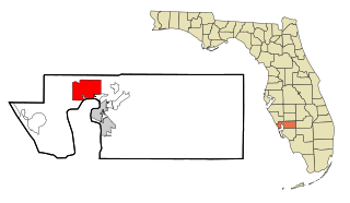
Hardee County is a county located in the Florida Heartland of the Central Florida region in the U.S. state of Florida. As of the 2020 census, the population was 25,327. Its county seat is Wauchula.

<span class="mw-page-title-main">Polk County, Florida</span> County in Florida

Polk County is located in the central portion of the U.S. state of Florida. The county population was 725,046, as of the 2020 census, and estimated to be 818,330, as of July 1, 2023. Its county seat is Bartow, and its largest city is Lakeland.

<span class="mw-page-title-main">Bridge City, Texas</span> City in Texas, United States

Bridge City is a city in Orange County, Texas, United States. It is 100 miles east of Houston, near the Gulf of Mexico. The population was 9,546 at the 2020 census. The town borders the Neches River and Cow Bayou. It is part of the Beaumont–Port Arthur Metropolitan Statistical Area. The area is mostly known for its association with the petroleum products (oil) industry.

<span class="mw-page-title-main">Albertville, Alabama</span> City in Alabama, United States

Albertville is a city in Marshall County, Alabama, United States, and is included in the Huntsville-Decatur Combined Statistical Area. The population was 22,386 at the 2020 census. It is the largest city in Marshall County.

<span class="mw-page-title-main">Dauphin Island, Alabama</span> Town in Alabama, United States

Dauphin Island is an island town in Mobile County, Alabama, United States, on a barrier island of the same name, in the Gulf of Mexico. It incorporated in 1988. The population was 1,778 at the 2020 census, up from 1,238 at the 2010 census. The town is part of the Mobile metropolitan area. The island was renamed for Louis XIV of France's great-grandson and heir, the dauphin, the future Louis XV of France. The name of the island is often mistaken as Dolphin Island; the word dauphin is French for dolphin, but historically, the term was used as the title of the heir apparent to the French monarch.

<span class="mw-page-title-main">Mexico Beach, Florida</span> City in Florida, United States

Mexico Beach is a city in Bay County, Florida, United States. It is located 25 miles (40 km) southeast of Panama City. It is part of the Panama City-Panama City Beach, Florida Metropolitan Statistical Area. The population was 916 at the 2020 census.

<span class="mw-page-title-main">Port Charlotte, Florida</span> Census-designated place in Florida, United States

Port Charlotte is an unincorporated community and census-designated place (CDP) in Charlotte County, Florida, United States. The population was 60,625 at the 2020 census, up from 54,392 at the 2010 census. It is part of the Punta Gorda, Florida Metropolitan Statistical Area, included in the North Port-Bradenton, Florida Combined Statistical Area.

<span class="mw-page-title-main">Naples, Florida</span> City in Florida, United States

Naples is a city in Collier County, Florida, United States. As of the 2020 census, the population was 19,115, down from 19,539 at the 2010 census. Naples is a principal city of the Naples–Marco Island metropolitan area, which had a population of about 375,752 as of 2020. Naples' USPS City population includes most of the communities in Collier County with the notable exceptions of Immokalee, Marco Island, Ave Maria, Everglades City, and a few others, and thus Naples' USPS City population is approximately 333,083.

<span class="mw-page-title-main">Pensacola, Florida</span> City in Florida, United States

Pensacola is the westernmost city in the Florida Panhandle. It is the county seat and only incorporated city of Escambia County, Florida, United States. At the 2020 census, the population was 54,312. It is the principal city of the Pensacola metropolitan area, which had 509,905 residents in 2020.

<span class="mw-page-title-main">Wauchula, Florida</span> City in Florida, United States of America

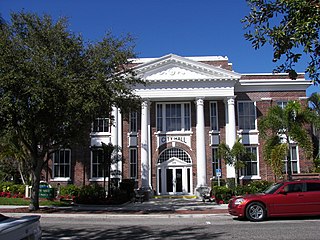
Wauchula is a city and the county seat of Hardee County, Florida, United States. As of the 2020 census, it had a population of 4,900.

<span class="mw-page-title-main">Bonita Springs, Florida</span> City in Florida, United States

Bonita Springs is a city in Lee County, Florida, United States. The population was 53,644 at the 2020 census, up from 43,914 at the 2010 census. It is part of the Cape Coral-Fort Myers, Florida Metropolitan Statistical Area, on the state's southwest coast.

<span class="mw-page-title-main">Captiva, Florida</span> Census-designated place in Florida, United States

Captiva is an unincorporated community and census-designated place (CDP) in Lee County, Florida, United States. It is located on Captiva Island. As of the 2020 census, the population was 318, down from 583 at the 2010 census. It is part of the Cape Coral-Fort Myers, Florida Metropolitan Statistical Area.

<span class="mw-page-title-main">Kissimmee, Florida</span> City in Florida, United States

Kissimmee is the largest city and county seat of Osceola County, Florida, United States. As of the 2020 census, the population was 79,226. It is a Principal City of the Orlando-Kissimmee-Sanford, Florida, Metropolitan Statistical Area, which had a 2020 population of 2,673,376. The Census Bureau defines an urban area with Kissimmee as the principal city, which is separated from the Orlando urban area. The Kissimmee–St. Cloud, FL urban area had a 2020 population of 418,404, making it the 100th largest in the United States.

<span class="mw-page-title-main">Haines City, Florida</span> City in Florida, United States

Haines City is a city in Polk County, Florida, United States. Its population was 26,669 at the 2020 census. It is part of the Lakeland–Winter Haven Metropolitan Statistical Area.

<span class="mw-page-title-main">Oviedo, Florida</span> City in Florida, United States

Oviedo is a city in Seminole County, Florida, United States. As of 2020, the population was 40,059. It is part of the Orlando–Kissimmee–Sanford Metropolitan Statistical Area. Oviedo was known for its agriculture, historic houses and buildings, as well as its population of chickens used to roam the downtown area. Although the city has historically been rural, in recent years it has had an influx of new developments to support its rapid growth, due to its proximity to the University of Central Florida and the Central Florida Research Park.

<span class="mw-page-title-main">St. Marks, Florida</span> City in Florida, United States

St. Marks is a city in Wakulla County, Florida, United States. It is part of the Tallahassee metropolitan area. St. Marks is located on the Florida Panhandle in North Florida, along the Gulf of Mexico. As of 2020, the population according to the U.S. Census Bureau is 274.

<span class="mw-page-title-main">Pascagoula, Mississippi</span> City in Mississippi, United States

Pascagoula is a city in Jackson County, Mississippi, United States. It is the principal city of the Pascagoula metropolitan area, and is part of the Gulfport–Biloxi–Pascagoula Combined Statistical Area and the Gulfport-Biloxi metropolitan area. The population was 22,392 at the 2010 census, down from 26,200 at the 2000 census. In 2019 the population was 21,699. It is the county seat of Jackson County.

<span class="mw-page-title-main">Hurricane Charley</span> Category 4 Atlantic hurricane in 2004

Hurricane Charley was the first of four separate hurricanes to impact or strike Florida during 2004, along with Frances, Ivan and Jeanne, as well as one of the strongest hurricanes ever to strike the United States. It was the third named storm, the second hurricane, and the second major hurricane of the 2004 Atlantic hurricane season. Charley lasted from August 9 to 15, and at its peak intensity it attained 150 mph (240 km/h) winds, making it a strong Category 4 hurricane on the Saffir–Simpson scale. It made landfall in Southwest Florida at maximum strength, making it the strongest hurricane to hit the United States since Hurricane Andrew struck Florida in 1992 and tied with Hurricane Ian as the strongest hurricane to hit southwest Florida in recorded history.

<span class="mw-page-title-main">Punta Gorda, Florida</span> City in Florida, United States

Punta Gorda is a city located in Southwest Florida and is the county seat of Charlotte County, Florida, United States. As of the 2020 U.S. Census the city had a population of 19,471, up from 16,641 at the 2010 census. Punta Gorda is the principal city of the Punta Gorda, Florida Metropolitan Statistical Area, part of the North Port-Bradenton Florida Combined Statistical Area.

References

  1. "2020 U.S. Gazetteer Files". United States Census Bureau. Retrieved October 31, 2021.
  2. "City Name Origins". Florida Department of State, Division of Historical Resources. Retrieved October 19, 2015.
  3. "History of Arcadia, Florida". Arcadia Main Street. Archived from the original on April 30, 2018. Retrieved April 30, 2018.
  4. Turner, Gregg (2003). A Short History of Florida Railroads. Arcadia Publishing. ISBN   978-0-7385-2421-4.
  5. "The Ray Brothers, a Sad Story of Ignorance and Intolerance". THE UNFINISHED PYRAMID. January 27, 2019. Retrieved September 11, 2022.
  6. "2004 Hurricane Charley 10 year anniversary". South Dade News Leader. Retrieved July 25, 2022.
  7. "Desoto Memorial Hospital Recovers from Hurricane Charley | FEMA.gov". www.fema.gov. Retrieved July 25, 2022.
  8. "Arcadia Moves On 10 Years After Hurricane Charley". WUSF Public Media. August 10, 2014. Retrieved July 25, 2022.
  9. Cummings, Ian; Herald-Tribune (August 8, 2014). "In DeSoto County, Charley's wounds linger". Extra. Retrieved July 25, 2022.
  10. Snyder, David; Finkel, David (August 16, 2004). "Fla. Begins Recovery From Deadly Storm". The Washington Post. Retrieved July 25, 2022.
  11. Kimel, Earle. "Peace River crests near record high, flooding homes". Sarasota Herald-Tribune. Retrieved July 25, 2022.
  12. "COVID-19 – City of Arcadia". arcadia-fl.gov. Retrieved July 25, 2022.
  13. "U.S. Climate Normals Quick Access – Station: Arcadia, FL". National Oceanic and Atmospheric Administration. Retrieved April 3, 2023.
  14. "xmACIS2". National Oceanic and Atmospheric Administration. Retrieved April 3, 2023.
  15. "Census of Population and Housing". Census.gov. Retrieved June 4, 2015.
  16. "P2 HISPANIC OR LATINO, AND NOT HISPANIC OR LATINO BY RACE - 2010: DEC Redistricting Data (PL 94-171) - Arcadia city, Florida". United States Census Bureau .
  17. "P2 HISPANIC OR LATINO, AND NOT HISPANIC OR LATINO BY RACE - 2020: DEC Redistricting Data (PL 94-171) - Arcadia city, Florida". United States Census Bureau .
  18. "S1101 HOUSEHOLDS AND FAMILIES - 2020: Arcadia city, Florida". United States Census Bureau .
  19. 1 2 3 "QuickFacts Arcadia city, Florida". United States Census Bureau. Retrieved June 20, 2022.
  20. "S1101 HOUSEHOLDS AND FAMILIES - 2010: Arcadia city, Florida". United States Census Bureau .
  21. Lane, Mark (1970). Arcadia. Holt, Rinehart and Winston. ISBN   978-0030818547.