Related Research Articles
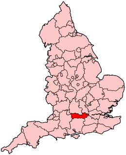
Reading East is a constituency represented in the House of Commons of the UK Parliament since 2017 by Matt Rodda, of the Labour Party. The seat is one of two won by a Labour candidate in 2017 from a total of eight covering Berkshire. Rodda's 2017 win was one of 30 net gains of the Labour Party.

Katesgrove is an inner-town district immediately to the south of the centre of the town of Reading, in the English county of Berkshire. It is bounded on the north by the Inner Distribution Road, on the east by Sidmouth Street, Kendrick Road and Northumberland Avenue, on the south by Long Barn Lane and Rose Kiln Lane and on the west by the River Kennet.

Reading Borough Council is the local authority for the Borough of Reading in the English county of Berkshire. It is a unitary authority, having the powers of a non-metropolitan county and district council combined. Berkshire is purely a ceremonial county, with no administrative responsibilities.
Milton Keynes Borough Council is the local authority for the Borough of Milton Keynes, a unitary authority in Buckinghamshire, England. Until 1 April 1997 it was a non-metropolitan district.
Abbey is an electoral ward of the Borough of Reading, in the English county of Berkshire. The ruins of Reading Abbey lie within the boundaries of the ward, a fact from which it derives its name. The ward covers the centre of the town, south of the River Thames, and is bordered by Battle, Thames, Redlands, Katesgrove and Coley wards. Although including significant portions of both the suburbs of West Reading and East Reading, the ward lies almost entirely within the Reading East parliamentary constituency, with only a few streets to the west of George Street in the Reading West parliamentary constituency.
Caversham is an electoral ward of the Borough of Reading, in the English county of Berkshire. It is to the north of the town centre, in the suburb of Caversham to the north of the River Thames, and is bordered by Thames, Peppard and Abbey wards.
Church is an electoral ward of the Borough of Reading, in the English county of Berkshire. It is covers an area south and south-east of the town centre, and is bordered by Katesgrove, Park, Redlands and Whitley wards.
Kentwood is an electoral ward of the Borough of Reading, in the English county of Berkshire. It consists of the northern part of the suburb of Tilehurst, in the west of Reading, south of the River Thames. The ward is bordered by Caversham Heights and Battle wards to the east, and Norcot and Tilehurst wards to the south. To the west the ward is bordered by the reduced civil parish of Tilehurst in the district of West Berkshire which is the remainder of the larger ancient parish, before the expansion of the Borough of Reading. The ward has schools and churches bearing a Tilehurst, rather than Reading name.
Mapledurham was an electoral ward of the Borough of Reading, in the English county of Berkshire, which was abolished in the boundary changes prior to the 2022 Reading Borough Council election. The ward's area was joined with part of that of the former Thames ward to form the new Caversham Heights ward.

Coley is an electoral ward of the Borough of Reading, in the English county of Berkshire. Until the 2022 Reading Borough Council election, it was known as Minster ward and had slightly different boundaries.
Park is an electoral ward of the Borough of Reading, in the English county of Berkshire. It takes its name from Palmer Park, which lies at its centre.
Emmer Green is an electoral ward of the Borough of Reading, in the English county of Berkshire. Until the 2022 Reading Borough Council election, it was known as Peppard ward and had slightly different boundaries.
Redlands is an electoral ward of the Borough of Reading, in the English county of Berkshire. It is situated to the south-east of the town centre, and is bordered by Abbey, Park, Church and Katesgrove wards.
Thames was an electoral ward of the Borough of Reading, in the English county of Berkshire, until it was abolished in the boundary changes prior to the 2022 Reading Borough Council election. It should not be confused with the ward of the same name that was created by those boundary changes, but which has no area in common with this former ward.
Tilehurst is an electoral ward of the Borough of Reading, in the English county of Berkshire. It forms part of the larger Reading suburb of Tilehurst, which also includes parts of the borough's Kentwood and Norcot wards, together with the civil parish of Tilehurst Without that is outside the borough boundary in the district of West Berkshire. The ward is bordered, in clockwise order, by Norcot ward, Tilehurst Without civil parish and Kentwood ward. It lies entirely within the Reading West parliamentary constituency.
Reading Borough Council is the council for the unitary authority of Reading in Berkshire, England. Until 1 April 1998 it was a non-metropolitan district.
The 2006 Reading Borough Council election was held on 4 May 2006, at the same time as other local elections across England. Seventeen of the 46 seats on Reading Borough Council were up for election, being the usual third of the council plus two by-elections. The by-election in Southcote ward was caused by the resignation of Labour councillor Christopher Swaine, and the by-election in Thames was caused by the resignation of Conservative councillor Rob Wilson, who had been elected as the member of parliament for Reading East the previous year. Labour lost three seats at the election: two to the Conservatives and one to the Liberal Democrats. The Conservatives took the largest number of votes across the borough for the first time since 1992. Despite these losses, Labour remained in control of the council, with David Sutton continuing as leader of the party and the council.
Thames is an electoral ward of the Borough of Reading, in the English county of Berkshire. It includes areas on both sides of both the River Thames and the River Kennet, to the north and east of the centre of Reading on the south bank, and to the east of the centre of Caversham on the north bank. It should not be confused with the ward of the same name that existed prior to the 2022 Reading Borough Council election, with which it has no area in common.
Caversham Heights is an electoral ward of the Borough of Reading, in the English county of Berkshire. The ward was created by a boundary reorganisation prior to the 2022 Reading Borough Council election, and has replaced the Mapledurham ward, with the addition of parts of the old Thames and Peppard wards. During the reorganisation process, the ward was known as The Heights, but the name was subsequent changed as a result of public consultation.
References
- ↑ "Final recommendations on the future electoral arrangements for Reading" (PDF). Report to the Electoral Commission. Boundary Committee for England. Archived from the original (PDF) on 4 June 2012. Retrieved 5 May 2012.
- ↑ Election Maps (Map). Ordnance Survey. Retrieved 13 June 2022.
- ↑ "Local Election 3 May 2012". Reading Borough Council. Archived from the original on 20 November 2012. Retrieved 5 May 2012.