
Reading is a town and borough in Berkshire, England. Most of its built-up area lies within the Borough of Reading, although some outer suburbs are parts of neighbouring local authority areas. Located in the Thames Valley at the confluence of the rivers Thames and Kennet, Reading is 40 miles (64 km) east of Swindon, 25 miles (40 km) south of Oxford, 40 miles (64 km) west of London and 16 miles (26 km) north of Basingstoke.
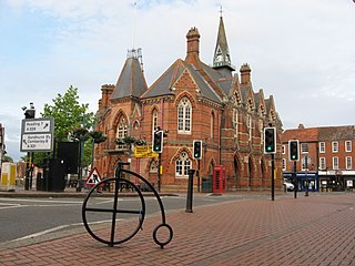
Wokingham is a market town and civil parish in Berkshire, England, 37 miles (60 km) west of London, 7 miles (11 km) southeast of Reading, 8 miles (13 km) north of Camberley and 4 miles (6 km) west of Bracknell. It is the main administrative centre of the wider Borough of Wokingham. In 2011 it had a population of 50,320.

Sandhurst is a town and civil parish in the Bracknell Forest borough in Berkshire, England. It is in the south eastern corner of Berkshire, and is situated 32 miles (51 km) west-southwest of central London, 2.5 miles (4.0 km) north west of Camberley and 5 miles (8.0 km) south of Bracknell. Sandhurst is known worldwide as the location of the Royal Military Academy Sandhurst. Despite its close proximity to Camberley, Sandhurst is also home to a large and well-known out-of-town mercantile development. The site is named "The Meadows" and has a Tesco Extra hypermarket and a Marks & Spencer, two of the largest in the country. A large Next clothing and homeware store is open on the site of the old Homebase.
Earley is a town and civil parish in the Borough of Wokingham, Berkshire, England. Along with the neighbouring town of Woodley, the Office for National Statistics places Earley within the Reading/Wokingham Urban Area; for the purposes of local government it falls within the Borough of Wokingham, outside the area of Reading Borough Council. Its name is sometimes spelt Erleigh or Erlegh and consists of a number of smaller areas, including Maiden Erlegh and Lower Earley, and lies some 3 miles (5 km) south and east of the centre of Reading, and some 4 miles (6 km) northwest of Wokingham. It had a population of 32,036 at the 2011 Census.
Tilehurst is a suburb of the town of Reading in the county of Berkshire, England. It lies to the west of the centre of Reading; it extends from the River Thames in the north to the A4 road in the south.

Twyford is a large village and civil parish in the Borough of Wokingham in Berkshire, England. It had a population of 6,618 in the 2011 Census. It is in the Thames Valley and on the A4 between Reading and Maidenhead, close to Henley-on-Thames and Wokingham.
Holybrook is a civil parish, forming a contiguous part of Reading in West Berkshire and is a mixture of urban, suburban land with watercourses and flood meadows in Berkshire, England. The parish takes its name from the Holy Brook, a watercourse which forms its southern boundary and which is a corollary of the River Kennet. Its main settlements are part of Calcot those commonly known as Beansheaf Farm and Fords Farm, Holybrook and occasionally considered part of Calcot or Southcote which overlaps with this area.

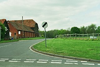
Calcot, or Calcot Row, is a village in West Berkshire, England. Calcot is within the built-up area of Reading, located about 3 miles (4.8 km) out of the town centre, and straddles the historic A4 Bath Road. It sits between the hamlet of Horncastle and Junction 12 of the M4 motorway.

Finchampstead is a village and civil parish in the Wokingham Borough in the shire of Berkshire, England. Its northern extremity is 2 miles (3 km) south of Wokingham, 5 miles (8 km) west of Bracknell, 8 miles (13 km) south-east of Reading, and 34 miles (55 km) west of Central London. It is an affluent area, with the village ranking as Britain's 31st wealthiest. It has a high standard of living and is rated as one of the most desirable places to live in the United Kingdom.
Swallowfield is a village and civil parish in Berkshire, England, about 5 miles (8 km) south of Reading, and 1 mile (1.6 km) north of the county boundary with Hampshire.

Lower Earley is a suburb which forms the southern portion of the civil parish of Earley in the Borough of Wokingham in Berkshire, England. Along with neighbouring Earley, Winnersh, Woodley and Shinfield, It forms part of a part of the Reading/Wokingham Urban Area.

Shinfield is a village and civil parish in the Borough of Wokingham, Berkshire, England. It lies just south of Reading, around 3 miles (4.8 km) from the town centre, and covers an area of 4,313 acres (17.45 km2). Shinfield Park is the northern part of the parish, becoming physically separated from Reading when the M4 motorway was constructed in 1971.

Grazeley is an area covering the small villages of Grazeley in the civil parish of Shinfield and Grazeley Green in the civil parish of Wokefield, 4 miles (6.4 km) south of Reading in the English county of Berkshire. To the east is the village of Spencers Wood, to the west is Wokefield and to the south is Beech Hill.
Calcot Park is a country house, estate, and golf club in the English county of Berkshire. It is situated between Calcot and Tilehurst, suburbs of the town of Reading, and within the civil parish of Tilehurst. It is north of the Bath Road.
Woolley Green is a village to the west of Maidenhead in the county of Berkshire, England.
Temple Park is a suburb of Bracknell in the English county of Berkshire and part of the civil parish of Binfield. It was built during the 1990s as the town continued to expand on open countryside between Bracknell and Binfield.

Greenham and Crookham Commons are two adjoining public park areas of 280.5-hectare (693-acre) common land designated as a biological Site of Special Scientific Interest (SSSI) in the civil parishes of Greenham and Thatcham, on the southern outskirts of Newbury in the English county of Berkshire.

Ardington and Lockinge are two civil parishes in the Vale of White Horse district, centred about 2 miles (3 km) east of Wantage, Oxfordshire, that share a single parish council. The two parishes were part of Berkshire until 1974 when they were transferred to Oxfordshire.
Tilehurst or Tilehurst Without is a civil parish in the district of West Berkshire, in the county of Berkshire, England. It includes part of the Reading suburb of Tilehurst that lies outside the Reading Borough boundary, together with the northern part of the adjoining suburb of Calcot, and a small rural area west of the two suburbs.

