Miami, officially the City of Miami, is a coastal metropolis in the U.S. state of Florida and the seat of Miami-Dade County in South Florida. It is the core of the much larger Miami metropolitan area, which, with a population of 6.14 million, is the second-largest metropolitan area in the Southeast after Atlanta, and the ninth-largest in the United States. With a population of 442,241 within its city limits as of the 2020 census, Miami is the second-most populous city proper in Florida after Jacksonville. Miami has the third-largest skyline in the U.S. with over 300 high-rises, 58 of which exceed 491 ft (150 m).

Aventura is a planned suburban city in northeastern Miami-Dade County, Florida, United States, 15 miles (24 km) north of Miami and part of the Miami metropolitan area of South Florida. The city is especially known for Aventura Mall, the third largest mall in the United States by total square feet of retail space and the largest mall in Florida.

Bay Harbor Islands is a town in Miami-Dade County, Florida, United States. The city is part of the Miami metropolitan area of South Florida. It is separated from the mainland by Biscayne Bay. The population was 5,922 at the 2020 US census.

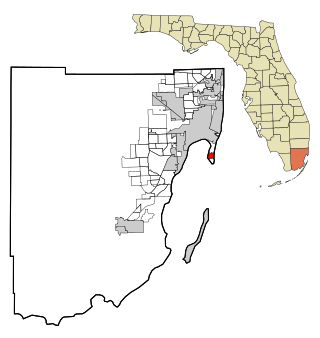
Cutler Bay is an incorporated town in Miami-Dade County, Florida, United States, established in 2005. With a population of 45,425 as of the 2020 US census, it is part of the Miami metropolitan area of South Florida. Cutler Bay is the 9th most populous of the 34 municipalities that make up Miami's urban core, and the 33rd most populous of the 163 municipalities.
Key Biscayne is an island village in Miami-Dade County, Florida, United States. The village is part of the Miami metropolitan area of South Florida. The population was 14,809 at the 2020 census, up from 12,344 in 2010.
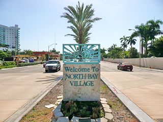
North Bay Village is a city located in Miami-Dade County, Florida. The city is part of the Miami metropolitan area of South Florida. As of the 2020 census, the city had a total population of 8,159.

North Miami is a suburban city located in northeast Miami-Dade County, Florida, United States, about 10 miles (16 km) north of Miami. The city lies on Biscayne Bay and hosts the Biscayne Bay Campus of Florida International University.. Originally the "Town of Arch Creek", the area was incorporated as the "Town of Miami Shores", which was renamed the "Town of North Miami" in 1931. It was reincorporated as a city in 1953. The city is part of the Miami metropolitan area of South Florida.

Coconut Grove, also known colloquially as The Grove, is an affluent and the oldest continuously inhabited neighborhood of Miami in Miami-Dade County, Florida. The neighborhood is roughly bounded by North Prospect Drive to the south, LeJeune Road to the west, South Dixie Highway and Rickenbacker Causeway to the north, and Biscayne Bay to the east. It is south of the neighborhoods of Brickell and The Roads and east of Coral Gables. The neighborhood's name has been sometimes spelled "Cocoanut Grove" but the definitive spelling "Coconut Grove" was established when the city was incorporated in 1919.

Biscayne National Park is an American national park located south of Miami, Florida in Miami-Dade County. The park preserves Biscayne Bay and its offshore barrier reefs. Ninety-five percent of the park is water, and the shore of the bay is the location of an extensive mangrove forest. The park covers 172,971 acres and includes Elliott Key, the park's largest island and northernmost of the true Florida Keys, formed from fossilized coral reef. The islands farther north in the park are transitional islands of coral and sand. The offshore portion of the park includes the northernmost region of the Florida Reef, one of the largest coral reefs in the world.

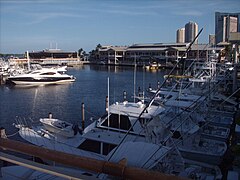
Biscayne Bay is a lagoon with characteristics of an estuary located on the Atlantic coast of South Florida. The northern end of the lagoon is surrounded by the densely developed heart of the Miami metropolitan area while the southern end is largely undeveloped with a large portion of the lagoon included in Biscayne National Park.

Miami Modernist architecture, or MiMo, is a regional style of architecture that developed in South Florida during the post-war period. The style was internationally recognized as a regionalist response to the International Style. It can be seen in most of the larger Miami and Miami Beach resorts built after the Great Depression. Because MiMo styling was not just a response to international architectural movements but also to client demands, themes of glamour, fun, and material excess were added to otherwise stark, minimalist, and efficient styles of the era. The style can be most observed today in Middle and Upper Miami Beach along Collins Avenue, as well as along the Biscayne Boulevard corridor starting from around Midtown, through the Design District and into the Upper Eastside.

Little Haiti, is a neighborhood of Miami, Florida, United States. It is known historically as Lemon City, Little River and Edison. It is home to Haitian immigrant residents, as well as residents from the rest of the Caribbean.

State Road 886, also known as Port Boulevard, is a causeway connecting the Port of Miami with downtown Miami, Florida. Its western terminus is an intersection with U.S. Route 1 just north of Bayside Marketplace, and its eastern terminus is at the Port of Miami entrance. It received its FDOT designation in 1980.

The Venetian Islands are a chain of artificial islands in Biscayne Bay in the cities of Miami and Miami Beach, Florida. The islands are, from west to east: Biscayne Island (Miami), San Marco Island (Miami), San Marino Island, Di Lido Island, Rivo Alto Island, and Belle Isle. Flagler Monument Island remains an uninhabited picnic island, originally built in 1920 as a memorial to railroad pioneer Henry Flagler. The islands are connected by bridges from the Miami mainland to Miami Beach.
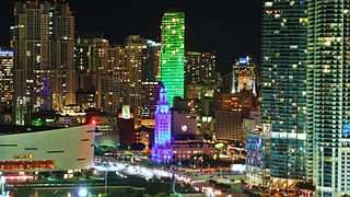
Downtown Miami is the urban city center of Miami, Florida, United States. The city's greater downtown region consists of the Central Business District, Brickell, the Historic District, Government Center, the Arts & Entertainment District, and Park West. It is divided by the Miami River and is bordered by Midtown Miami's Edgewater, and Wynwood sections to its north, Biscayne Bay to its east, the Health District and Overtown to its west, and Coconut Grove to its south.

The Upper Eastside is a neighborhood in Miami, Florida. It is north of Edgewater, east of Little Haiti, south of the village of Miami Shores, and sits on Biscayne Bay. In geographical order from south to north and east to west, it contains the subdivisions of Magnolia Park, Bay Point, Morningside, Bayside, Belle Meade, Shorecrest, and Palm Grove. The MiMo District along Biscayne Boulevard in the area is host to many art galleries, shops and restaurants.

Maurice A. Ferré Park is a 30-acre (0.12 km2) public, urban park in downtown Miami, Florida. The park opened in 1976 on the site of several slips served by the Seaboard Air Line Railroad. It was originally named "Bicentennial Park" to celebrate the bicentennial of the United States in that same year. Today, the park is maintained by the Bayfront Park Management Trust. The park is bordered on the north by I-395, Metromover, and the former Miami Herald headquarters, on the south by the American Airlines Arena and Bayside Marketplace, on the west by Biscayne Boulevard and on the east by Biscayne Bay.

The Arts & Entertainment District, or previously known as Omni, is a neighborhood of Downtown Miami, Florida. It is bound roughly by North 19th Street to the north, North 10th Street to the south, North West 2nd Avenue to the west, and Biscayne Boulevard to the east.

Bayfront Park is a 32-acre (13 ha) public, urban park in Downtown Miami, Florida on Biscayne Bay.

The Central Business District (CBD) of Miami is the historic central business district and city center of what has become Greater Downtown Miami in Miami, Florida. Over 92,000 people work in Miami's Central Business District.