Miami-Dade Transit

Last updated
Miami-Dade Transit
Transit at Government Center.jpg
Metrorail (top), Metromover (middle), and Metrobus (bottom) at Government Center
Overview
OwnerMiami-Dade County
Locale Greater Miami
Transit type
Number of lines2 Metrorail lines
3 Metromover loops
90 Metrobus routes
1 Transitway
Number of stations Miami Intermodal Center
Government Center
23 (Metrorail)
22 (Metromover)
28 (South Dade Transitway)
Daily ridership248,700 (weekdays, Q3 2023) [1]
Annual ridership60,734,900 (2022) [2]
Chief executiveEulois Cléckley
Headquarters701 NW 1st Court
Miami, Florida
Website www.miamidade.gov/global/transportation/home.page
Operation
Began operationAugust 2, 1960 [3]
Operator(s)Miami-Dade Transit
Number of vehicles817 buses
136 Metrorail cars
42 Metromover cars
Rail transport in South Florida
BSicon CONTg.svg
BSicon CONTg.svg
BSicon STR.svg
BSicon HST.svg
BSicon STR.svg
Mangonia Park
Tri-Rail.svg
BSicon INT.svg
BSicon STR.svg
West Palm Beach
Tri-Rail.svg BSicon LOGO Amtrak2.svg Greyhound no dog.svg
BSicon STR.svg
BSicon BHF.svg
West Palm Beach
Brightlineicon.png
BSicon HST.svg
BSicon STR.svg
Lake Worth
Tri-Rail.svg
BSicon KMW.svg
BSicon STR.svg
Tri-Rail fare
zone boundary
BSicon HST.svg
BSicon STR.svg
Boynton Beach
Tri-Rail.svg
BSicon INT.svg
BSicon STR.svg
Delray Beach
Tri-Rail.svg BSicon LOGO Amtrak2.svg
BSicon KMW.svg
BSicon STR.svg
Tri-Rail fare
zone boundary
BSicon HST.svg
BSicon STR.svg
Boca Raton
Tri-Rail.svg
BSicon STR.svg
BSicon BHF.svg
Boca Raton
Brightlineicon.png
BSicon STR+GRZq.svg
BSicon GRZq.svg
BSicon STR+GRZq.svg
BSicon INT.svg
BSicon STR.svg
Deerfield Beach
Tri-Rail.svg BSicon LOGO Amtrak2.svg
BSicon HST.svg
BSicon STR.svg
Pompano Beach
Tri-Rail.svg
BSicon KMW.svg
BSicon STR.svg
Tri-Rail fare
zone boundary
BSicon HST.svg
BSicon STR.svg
Cypress Creek
Tri-Rail.svg
BSicon STR.svg
BSicon BHF.svg
Fort Lauderdale
Brightlineicon.png
BSicon hKRZWae.svg
BSicon WASSERq.svg
BSicon hKRZWae.svg
BSicon INT.svg
BSicon STR.svg
Fort Lauderdale
Tri-Rail.svg BSicon LOGO Amtrak2.svg
BSicon KMW.svg
BSicon STR.svg
Tri-Rail fare
zone boundary
BSicon HST.svg
BSicon STR.svg
Fort Lauderdale Airport
Tri-Rail.svg
BSicon HST.svg
BSicon STR.svg
Sheridan Street
Tri-Rail.svg Greyhound no dog.svg
BSicon INT.svg
BSicon STR.svg
Hollywood
Tri-Rail.svg BSicon LOGO Amtrak2.svg
BSicon KMW.svg
BSicon GRZq.svg
BSicon GRZq.svg
BSicon STR+GRZq.svg
Tri-Rail fare
zone boundary
BSicon STR.svg
BSicon BHF.svg
Aventura
Brightlineicon.png
BSicon HST2.svg
BSicon STRc3.svg
BSicon STR2.svg
BSicon STRc3.svg
Golden Glades
Tri-Rail.svg Greyhound no dog.svg
BSicon STRc1.svg
BSicon HST+4.svg
BSicon STRc1.svg
BSicon STR+4.svg
Opa-locka
Tri-Rail.svg
BSicon ABZgl.svg
BSicon KBHFeq.svg
BSicon STR.svg
Miami
BSicon LOGO Amtrak2.svg
BSicon lhSTRa@f.svg
BSicon gKBHFa.svg
BSicon STR.svg
BSicon STR.svg
Palmetto
BSicon ghKRZW.svg
BSicon STR.svg
BSicon STR.svg
BSicon ghBHF.svg
BSicon STR.svg
BSicon STR.svg
Okeechobee
BSicon ghBHF2.svg
BSicon ghSTRc3.svg
BSicon STR.svg
BSicon STR.svg
Hialeah
BSicon ghSTRc1.svg
BSicon MSTR2+4.svg
BSicon ghINT2+4.svg
BSicon STR.svg
BSicon ghSTRc3.svg
BSicon STR.svg
Tri-Rail and Metrorail Transfer
Tri-Rail.svg
BSicon ghSTRc1.svg
BSicon STR.svg
BSicon ghBHF+4.svg
BSicon STR.svg
Northside
BSicon ABZgl.svg
BSicon gmhKRZ.svg
BSicon ABZg+r.svg
BSicon STRc2.svg
BSicon STR3.svg
BSicon ghBHF.svg
BSicon STR.svg
Dr. Martin Luther King Jr. Plaza
BSicon STRc2.svg
BSicon h3STRc2q.svg
BSicon STR3+1.svg
BSicon STRc4.svg
BSicon hv3STR~RRq.svg
BSicon h3STRc3q.svg
BSicon ghBHF.svg
BSicon STR.svg
Brownsville
BSicon HST+1.svg
BSicon STRc4.svg
BSicon gh3STR+1.svg
BSicon gh3STRq-.svg
BSicon gh3ABZg+4.svg
BSicon STR.svg
Hialeah Market
Tri-Rail.svg
BSicon hKRZWae.svg
BSicon ghKRZW.svg
BSicon ghSTR.svg
BSicon STR.svg
BSicon STR2.svg
BSicon STRc3.svg
BSicon ghSTR.svg
BSicon ghBHF.svg
BSicon STR.svg
Earlington Heights
BSicon STRc1.svg
BSicon MSTR.svg
BSicon ghSTR.svg
BSicon STR2+4.svg
BSicon STRc3.svg
BSicon ghBHF.svg
BSicon STR.svg
Allapattah
BSicon hKINTa-L violet.svg
BSicon STRc1.svg
BSicon ghKINTe-M.svg
BSicon lINT-R.svg
BSicon ghSTRc2.svg
BSicon KINT4.svg
BSicon ghSTR3.svg
BSicon STR.svg
Miami Intermodal Center
Tri-Rail.svg Greyhound no dog.svg
BSicon hKBHFe violet.svg
BSicon ghSTRc2.svg
BSicon ghSTR3+1.svg
BSicon ghSTRc4.svg
BSicon STR.svg
Miami International Airport
Gnome-searchtool.svg
BSicon ghSTRc2.svg
BSicon ghBHF3+1.svg
BSicon ghSTRc4.svg
BSicon STRc2.svg
BSicon STR3.svg
Santa Clara
BSicon ghBHF+1.svg
BSicon ghSTRc4.svg
BSicon STRc2.svg
BSicon STR3+1.svg
BSicon STRc4.svg
Civic Center
BSicon ghBHF.svg
BSicon STRc2.svg
BSicon ABZ1+3f.svg
BSicon STRc4.svg
Culmer
BSicon ghSTR.svg
BSicon STR+1.svg
BSicon STR+c4.svg
BSicon uhKBHFa.svg
School Board
BSicon ghSTR.svg
BSicon STR.svg
BSicon hSTRa@f.svg
BSicon uhBHF.svg
Adrienne Arsht Center
BSicon ghSTR.svg
BSicon STR.svg
BSicon hSTR.svg
BSicon uhBHF.svg
Museum Park
BSicon ghSTR.svg
BSicon STR.svg
BSicon hSTR.svg
BSicon uhBHF.svg
Eleventh Street
BSicon ghSTR.svg
BSicon STR.svg
BSicon hSTR.svg
BSicon uhBHF.svg
Park West
BSicon ghSTR.svg
BSicon kSTR2.svg
BSicon hSTR.svg
BSicon uhBHF.svg
Freedom Tower
BSicon ghSTR.svg
BSicon kSTRc1.svg
BSicon hMSTR.svg
BSicon kSTRl+4.svg
BSicon lhSTRa@fq.svg
BSicon WSTRc2.svg
BSicon umhKRZ.svg
BSicon lhMSTR+r.svg
BSicon STR+r.svg
BSicon WASSER3.svg
BSicon ghSTR.svg
BSicon hSTR.svg
BSicon WSTRc1.svg
BSicon uhSTR.svg
BSicon lhSTRe@g.svg
BSicon WSTRc4.svg
BSicon eKBHFe.svg
PortMiami
(planned) Brightlineicon.png
BSicon HUBrg-R.svg
BSicon ghBHF.svg
BSicon HUB-Lq.svg
BSicon h3STRc2q.svg
BSicon hMSTR.svg
BSicon HUBlg-L.svg
BSicon hv3STR~RRq.svg
BSicon h3STRc3q.svg
BSicon uhSTR2.svg
BSicon uhSTRc3.svg
Historic Overtown/Lyric Theatre
BSicon HUB-R.svg
BSicon ghSTR.svg
BSicon uh3STR+1.svg
BSicon hMSTR.svg
BSicon HUBlf-L.svg
BSicon uh3STRq-.svg
BSicon uhSTRc1.svg
BSicon HUBlg-L.svg
BSicon uh3BHF+4.svg
BSicon uhSTR+4.svg
Wilkie D. Ferguson Jr.
BSicon HUB-R.svg
BSicon ghSTR.svg
BSicon uhSTR.svg
BSicon hKINTe.svg
BSicon HUBrg-L.svg
BSicon BLa.svg
BSicon HUBrf-L.svg
BSicon uhSTR.svg
BSicon uhSTR.svg
MiamiCentral
Tri-Rail.svg Brightlineicon.png Gnome-searchtool.svg
BSicon HUBlf-R.svg
BSicon ghINT-L.svg
BSicon uhINT-R.svg
BSicon HUB-Rq.svg
BSicon BLaq.svg
BSicon HUBrf-L.svg
BSicon BLr.svg
BSicon uhSTR.svg
BSicon uhSTR.svg
Government Center
BSicon ghSTR.svg
BSicon uhSTR.svg
BSicon uhBHFl.svg
BSicon uhABZgr+r.svg
College North
BSicon ghSTR.svg
BSicon uhSTR.svg
BSicon uhBHF.svg
College/Bayside
BSicon ghSTR.svg
BSicon uhSTR.svg
BSicon uhBHF.svg
First Street
BSicon ghSTR.svg
BSicon uhABZgl.svg
BSicon uhdSTRq.svg
BSicon uhSTR+r.svg
BSicon uhBHF.svg
Bayfront Park
BSicon ghSTR.svg
BSicon uhSTRf.svg
BSicon uhBHF(L)g.svg
BSicon uhSTR.svg
Miami Avenue
BSicon ghSTR.svg
BSicon uhBHF(R)f.svg
BSicon uhSTRg.svg
BSicon uhSTR.svg
Third Street
BSicon ghSTR.svg
BSicon uhABZgl+l.svg
BSicon uhdSTRq.svg
BSicon uhABZqlr.svg
BSicon uhdSTRq.svg
BSicon uhBHFr.svg
Knight Center
BSicon ghSTR.svg
BSicon uhBHF.svg
Riverwalk
BSicon ghKRZW.svg
BSicon uhKRZW.svg
Miami River
BSicon ghSTR.svg
BSicon uhBHF.svg
Fifth Street
BSicon ghSTR.svg
BSicon uhBHF.svg
Brickell City Centre
BSicon ghSTR.svg
BSicon uhBHF.svg
Tenth Street/Promenade
BSicon ghINT-L.svg
BSicon uhINT-R.svg
Brickell
BSicon ghSTR.svg
BSicon uhSTRl.svg
BSicon uhKBHFeq.svg
Financial District
BSicon ghBHF.svg
Vizcaya
BSicon ghBHF.svg
Coconut Grove
BSicon ghBHF.svg
Douglas Road
BSicon ghBHF.svg
University
BSicon ghBHF.svg
South Miami
BSicon ghBHF.svg
Dadeland North
BSicon ghKBHFe.svg
Dadeland South
BSicon BUS3.svg

BSicon TRAIN3.svg
BSicon STRq.svg
Amtrak, Brightline, and Tri-Rail
BSicon SUBWAY.svg
BSicon gSTRq.svg
Metrorail
BSicon MONO.svg
BSicon uSTRq.svg
Metromover
BSicon ICTS.svg
BSicon STRq violet.svg
MIA Mover
Wheelchair symbol.svg
All stations are accessible

Miami-Dade Transit (MDT) is the primary public transit authority of Miami, Florida and the greater Miami-Dade County area. It is the largest transit system in Florida and the 15th-largest transit system in the United States. [4] As of 2022, the system has 60,734,900 rides per year, or about 248,700 per weekday in the third quarter of 2023. MDT operates the Metrobus with their paratransit STS systems run by LSF. MDT also operates two rail transit systems: Metrorail and Metromover.

Contents

Metrobus operates over 93 routes, including the South-Dade Transitway. [5] MDT's main transit stations are Government Center in Downtown, and the Miami Intermodal Center in Grapeland Heights, which can access the Miami International Airport. [6]

Metrorail is composed of two rail lines (Green and Orange lines) with 23 stations radiating from the city center towards outlying neighborhoods north and south of Downtown. Metromover operates throughout the Downtown, Omni, and Brickell neighborhoods, and is composed of three rail loops and 22 stations. The opening of the Metrorail Orange Line in July 2012 significantly increased usage of the system. [7] As of 2013, rail fares collected were $23 million/yr and it cost $78 million/yr to operate the rail system. [8]

Tri-Rail is a separate entity and not controlled by MDT. Tri-Rail, a commuter rail system in the Miami metropolitan area, is directly connected at the Tri-Rail and Metrorail Transfer station, Miami Intermodal Center, and Government Center station.

History

In 1960, the Dade County Commission passed an ordinance creating the Metropolitan Transit Authority (MTA) to unify the different transit operations into one countywide service. This ordinance provided for the purchase, development, and operation of an adequate mass transit system by the County. These companies included the Miami Transit Company, Miami Beach Railway Company, South Miami Coach Lines, and Keys Transit Company on Key Biscayne and would be managed by National City Management Company. National City was dismissed as manager in 1974. [9] Over the years and under various administrations, MTA evolved into the Metro-Dade Transportation Administration, the Metro-Dade Transit Agency, the Miami-Dade Transit Agency, and is now known simply as Miami-Dade Transit (MDT).

Miami-Dade Transit, a county department of more than 4,000 employees, is the largest transit agency in the state of Florida and accounts for more than half of the trips taken on public transit in the state. MDT operates an accessible, integrated system of 93-plus Metrobus routes; the 22-mile (35 km) Metrorail rapid transit system; Metromover, a free Downtown people mover system; and the Paratransit division's Special Transportation Service. Metrobus routes cover more than 35-million miles annually, including limited service to Broward and Monroe counties. In 2004, MDT's Metrorail, Metromover, and Metrobus transported more than 96 million passengers, compared to 85 million the previous year.

2011 federal investigation

Miami-Dade Transit was undergoing a federal investigation by the Federal Transit Administration that includes several audits and a criminal investigation of the transit agency due to concerns over money mismanagement within the agency. [10] This caused a freezing of federal funds being granted to the county agency. In late 2010 the county manager claimed that it was 'not fraud' but rather accounting errors, poor management, and erroneous information given to the auditors that triggered the investigation, including a withdrawal of $15 million through the ECHO program that was made by a transit official two hours after a letter arrived in September 2010 from the FTA telling them withdrawals had been restricted. [11] The investigation and lack of funding let to emergency service cuts to Metrorail, Metrobus, and Metromover being considered by the agency by the middle of 2011, six months into the investigation and lack of funding which began in November 2010, causing MDT to lose $185 million in grant money. Assistant county manager Ysela Llort became responsible for Miami-Dade Transit after director Harpal Kapoor left in April 2011. Additionally, funding for the Metrorail airport link was jeopardized by the funding freeze. The FTA decided to continue funding under strict control in order to keep service cuts from happening. [12]

MDT headquarters are located in the Overtown Transit Village in Downtown Miami. [13]

Future

The SMART Program

The Strategic Miami Area Rapid Transit (SMART) Program involves the implementation of five rapid transit corridors in Miami-Dade County. [14] It includes new extensions of the current Metrorail and Metromover systems as well as the introduction of new forms of rapid transit, such as bus rapid transit (BRT).

South-Dade Transitway (South Corridor Bus Rapid Transit)

The South-Dade Transitway Corridor will become a gold standard bus rapid transit (BRT) line, including 2 terminals and 14 new iconic BRT stations, all featuring fare gates, center platform boarding, all-door and level boarding, next bus arrival screens, air-conditioned waiting areas, and other rail-like amenities. Along the transitway, signal preemption and level crossing gates will be implemented so that BRT vehicles never stop at a light. The BRT will use 60-foot New Flyer Xcelsior battery-electric articulated buses. [15] The project should be completed by fall of 2024. [16] [17]

North Corridor (Metrorail extension)

The North Corridor is an extension of the current Metrorail system along NW 27 Avenue from the Dr. Martin Luther King Jr. Plaza station to the north county line. It will be implemented in two phases. The first phase will extend the Metrorail to a station at the Hard Rock Stadium, with a stop at the Miami-Dade College North Campus. The second phase will include the remainder of the project, with a total of eight new stations added. [18] [19]

Northeast Corridor (Commuter rail)

The Northeast Corridor will feature commuter rail service (potentially Tri-Rail), [20] extending from MiamiCentral to the Aventura station along the existing Florida East Coast Railway (FEC) tracks. It will have seven stations for the service in Miami-Dade, with both of the terminal stations having access to Brightline. [21] [22] Service could begin as soon as 2028. [23]

East-West Corridor (Bus Rapid Transit)

The East-West Corridor consists of three BRT routes on dedicated bus lanes running from Tamiami Terminal to the Miami Intermodal Center and Government Center, as well as through the Blue Lagoon area. One of the routes will go on dedicated lanes, mainly along SR 836, and include four stations between Tamiami Terminal and the Miami Intermodal Center. [24]

In April 2023, the Miami-Dade Transportation Planning Organization (TPO) considered commuter rail service instead of BRT as the form of rapid transit for the reason that BRT is "no longer seen as practical" and that commuter rail service on the CSX Lehigh Spur has "become more flexible [on cost]." [25] [26] In January 2024, the TPO moved forward with the commuter rail plan as well as an alternative being Metromover along Flagler Street. [27]

Beach Corridor (Metromover extensions and bus/trolley lanes)

The Beach Corridor includes three rapid transit projects. The first is an extension of the current Metromover system along Miami Avenue from the School Board station to NW 41st Street. The second, known as BayLink, is another Metromover extension along the southern edge of MacArthur Causeway to Miami Beach, with stations in between. BayLink could begin service as soon as 2028. [28] The third is dedicated bus/trolley lanes along Washington Avenue from 5th Street to the Miami Beach Convention Center. [29]

Metrorail

A Metrorail train at Tri-Rail and Metrorail Transfer Station (2011) Metrorail-Tri-Rail.png
A Metrorail train at Tri-Rail and Metrorail Transfer Station (2011)

Metrorail is an elevated heavy rail rapid transit system. It has two lines on 24.4 mi (39 km) of track with termini west of Hialeah, at Miami International Airport, and in Kendall.

Metrorail serves the urban core of Miami, connecting the urban centers of Miami International Airport, the Health District, Downtown Miami, and Brickell with the northern developed neighborhoods of Hialeah and Medley to the northwest, and to suburban The Roads, Coconut Grove, Coral Gables, and South Miami, ending at Dadeland South in Kendall.

Metromover

A Metromover double-unit train in Arts & Entertainment District (2012) Metromover double-unit train Omni 2012-04.jpg
A Metromover double-unit train in Arts & Entertainment District (2012)

Metromover is a free, elevated, automated mass transit people mover that runs on three loops: the Downtown Inner Loop, Brickell Loop, and the Omni Loop. The systems total 4.4 miles (7.1 km) with 22 stations at roughly every two blocks in the greater Downtown area. Metromover serves the neighborhoods of Downtown, Arts & Entertainment District, Brickell, Park West, and Overtown.

Metrobus

NABI 40-LFW, photographed in 2019 1999 NABI 40LFW 040.17 Bus 9917.jpg
NABI 40-LFW, photographed in 2019
New Flyer DE60LFA at Adrienne Arsht Center Bus Terminal (2012) Miami Dade Transit route S (119) bus at Adrienne Arsht Center Bus Terminal.jpg
New Flyer DE60LFA at Adrienne Arsht Center Bus Terminal (2012)

The Metrobus network provides bus service throughout Miami-Dade County 365 days a year. It consists of about 93 routes and 880 buses, which connect most points in the county and part of southern Broward County as well. Seven of these routes operate around the clock: Routes 3, 11, 27, 38, 77 (last bus from Downtown Miami 1:10 am, first bus from Downtown Miami 4:10 am), L (No 24-hour service to Hialeah, all trips terminate at Northside Station) and S. Routes 246 Night Owl (served by LSF) & Route 500 Midnight Owl (County operated) which operate from midnight to 5 am. Most other routes operate from 4:30 am to 1:30 am. All Metrobuses are wheelchair accessible, in compliance with the Americans with Disabilities Act of 1990, and all county buses except for private run routes are equipped with bicycle racks. Some privatized routes trucks are receiving bike racks but very limited.

Bus route 301 (Dade-Monroe Express) extends into Monroe County, reaching Marathon, where a transfer is available to a Key West Transit bus proceeding further into the Keys. With the appropriate bus transfers, one can travel all the way from Key West to Jupiter entirely on public-transit buses.

Paratransit (STS)

Paratransit/Special Transportation Services (STS) is available for people with a mental or physical disability who cannot ride Metrobus, Metrorail, or Metromover. For $3.50 per one-way trip, STS offers shared-ride, door-to-door travel in accessible vehicles throughout most of Miami-Dade County, in some parts of south Broward County, and in the middle and northern Keys. STS operates 24 hours a day, 7 days a week, including most holidays. Service is run by private company.

Rates

The "EASY Card" system is a regional fare collection system with interoperable smartcards and equipment. The following information is specific to Miami-Dade Transit:

Since October 1, 2009, Miami-Dade Transit has used the EASY Card system [30] for fare collection.

On December 13, 2009 paper-based bus transfers were discontinued, and bus-to-bus transfers are now free only when using an EASY Card or EASY Ticket.

The current standard fare is $2.25 and reduced fare is $1.10. A standard monthly pass costs $112.50 and $56.25 for reduced fare (College Students). The monthly Metropass is loaded onto the EASY Card. Fare gates at all Metrorail stations does not accept any type of cash, [30] and require an EASY Card/Ticket, contactless device, or contactless debit/credit card to enter and exit the stations.

Reduced fares are available only to Medicare recipients, people with disabilities, and Miami-Dade students in grades K-12. Fare is free to kids below 42 inches (110 cm) tall with fare-paying rider. Full time college students may also purchase a College EASY Ticket to ride Metrobus or Metrorail at $56.25 at their college/university along with a valid Student ID. [33] Miami-Dade County employees can also receive discounted monthly rates and pre-tax savings by enrolling in the Monthly Pass Payroll Deduction program. [34]

All Miami-Dade senior citizens aged 65 years and older and with Social Security benefits ride free with a Golden Passport pass. Veterans residing in Miami-Dade and earning less than $22,000 annually ride free with the Patriot Passport pass.

As of August 21, 2019, and December 23, 2019 riders can use their smartphones/smartwatches and contactless credit/debt cards to board the Metrorail and Metrobus. (Accepting Apple Pay, Google Pay, Samsung Pay, Fitbit Pay etc.).

As part of the Better Bus Routes bus network redesign, fares are currently eliminated for all modes of transit through the end of the year.

Finances

In 2018, the annual operating expense was $552 million; annual revenue was $106 million. Each passenger trip cost $6.77. One-way rides on Metrobus and Metrorails cost $2.25; rides on Metromover were free of charge to passengers. [35] [36]

Passenger ridership

Passengers at Government Center Government Center rush hour.png
Passengers at Government Center

In February 2011, Miami-Dade Transit ridership totaled 336,067 passengers, including all Metrorail, Metromover and Metrobus lines. With a population of about 2.5 million in Miami-Dade County, Miami-Dade Transit accounts for 15% of the population's daily mode of transportation. Note: This figure does not include Tri-Rail, Miami's commuter rail operator.

Since the debut of Uber in the Miami area ridership has decreased each year, especially on the buses. By 2018, there were fewer riders than in 1999. In 2018, Metrorail and Metromover began to shut down earlier in the evening; the peak in-service fleet was cut by 4%; and service miles were cut by 2 million. [35]

Annual passenger ridership

YearMetrobus Metrorail Metromover Total ridership
199561,516,40014,445,4004,168,60080,130,400
199660,466,70014,245,0003,847,40078,559,100
199762,344,20013,923,7004,175,20080,443,100
199862,358,10013,298,9004,064,90079,721,900
199964,252,40013,769,4004,069,70082,091,500
200065,689,80014,023,6004,256,50083,969,900
200165,067,10013,678,0004,951,80083,696,900
200263,423,50013,932,1005,171,70082,527,300
200365,046,90014,318,5006,978,90086,344,300
200477,909,30015,987,6008,686,300102,583,200
200578,373,00017,001,0008,537,500103,911,500
200683,080,50017,388,1008,389,500108,858,100
200784,218,30017,672,0008,838,800110,729,100
200886,409,200*19,075,900*8,723,700114,208,800*
200973,104,90017,792,1007,986,10098,883,100
201070,942,00017,438,4008,121,00096,501,400
201176,858,20018,295,5009,219,600*104,373,300
2016 [37] ---96,228,800
2018 [35] ---81,600,000

* Record highs

Weekday passenger ridership averages

YearMetrobus Metrorail [38] Metromover Total daily passengers
1998207,04844,87113,269265,188
1999209,11146,77413,880269,765
2000212,92747,25614,383274,566
2001211,82346,66416,849275,336
2002204,94147,06416,444268,449
2003215,30651,24825,521292,076
2004234,10955,29428,192317,595
2005246,02359,70028,473334,195
2006259,37558,35827,042344,775
2007264,467
(record high)
59,70828,058352,233
(record high)
2008259,01863,710
(record high)
26,682349,410
2009233,85859,99225,883319,733
2010227,88359,90027,175314,958
2011245,35862,55929,775
(record high)
337,692

See also

Related Research Articles

<span class="mw-page-title-main">METRORail</span> 22.7-mile (36.5 km) light rail system in Houston, Texas

METRORail is the 22.7-mile (36.5 km) light rail system in Houston, Texas. In 2022, the system had a ridership of 12,176,700, or about 44,300 per weekday as of the third quarter of 2023. METRORail ranks as the second most-traveled light rail system in the Southern United States and the 12th most-traveled light rail system in the United States, and has the highest ridership per mile for light rail systems in the Southern US. METRORail is operated by the Metropolitan Transit Authority of Harris County (METRO).

<span class="mw-page-title-main">Bus rapid transit</span> Public transport system

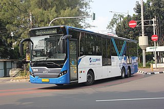
Bus rapid transit (BRT), also referred to as a busway or transitway, is a bus-based public transport system designed to have much more capacity, reliability and other quality features than a conventional bus system. Typically, a BRT system includes roadways that are dedicated to buses, and gives priority to buses at intersections where buses may interact with other traffic; alongside design features to reduce delays caused by passengers boarding or leaving buses, or paying fares. BRT aims to combine the capacity and speed of a light rail transit (LRT) or mass rapid transit (MRT) system with the flexibility, lower cost and simplicity of a bus system.

<span class="mw-page-title-main">Tri-Rail</span> Commuter rail service in South Florida

Tri-Rail is a commuter rail service linking Miami, Fort Lauderdale and West Palm Beach in Florida, United States. The Tri prefix in the name refers to the three counties served by the railroad: Palm Beach, Broward, and Miami-Dade. Tri-Rail is managed by the South Florida Regional Transportation Authority (SFRTA) along CSX Transportation's former Miami Subdivision; the line is now wholly owned by the Florida DOT. The 80.0-mile-long (128.7 km) system has 19 stations along the Southeast Florida coast, and connects directly to Amtrak at numerous stations, to Metrorail at the Tri-Rail and Metrorail Transfer station, Miami Intermodal Center, and MiamiCentral, and to Brightline at MiamiCentral.

<span class="mw-page-title-main">Metromover</span> Free of charge automated people mover system in downtown Miami, Florida

Metromover is an automated people mover system operated by Miami-Dade Transit in Miami, Florida, United States. Metromover serves the Downtown Miami, Brickell, Park West and Arts & Entertainment District neighborhoods. Metromover connects directly with Metrorail at Government Center and Brickell stations. It also connects to Metrobus with dedicated bus loops at Government Center and Adrienne Arsht Center station. It originally began service to the Downtown/Inner Loop on April 17, 1986, and was later expanded with the Omni and Brickell Loop extensions on May 26, 1994.

<span class="mw-page-title-main">Palmetto station</span> Miami-Dade Transit metro station

Palmetto station is a Metrorail rapid transit station in unincorporated Miami-Dade County, Florida, United States, just near the town of Medley. It is the current northern terminus of the Metrorail system. This station is located near the intersection of Northwest 77th Street and 79 Avenue, opening to service May 30, 2003. It is adjacent to the Palmetto Expressway, providing convenience to west Miami-Dade and Broward commuters traveling into Downtown Miami. The station is in a low-density warehouse area and has low ridership. In 2023 a 900-unit housing project was proposed for the site.900 apartments

<span class="mw-page-title-main">Santa Clara station (Metrorail)</span> Miami-Dade Transit metro station

Santa Clara station is a station on the Metrorail rapid transit system in the industrial district of the Allapattah neighborhood in Miami, Florida. This station is located near the intersection of Northwest 12th Avenue and 20th Street. It opened to service December 17, 1984. Along with Brownsville station, Santa Clara is generally the lowest ridership station on the system.

<span class="mw-page-title-main">Government Center station (Miami)</span> Miami-Dade Transit metro station

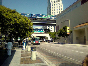
Government Center station is an intermodal transit hub in the Government Center district of Downtown Miami, Florida. It is operated by Miami-Dade Transit and serves as a transfer station for the Metrorail and Metromover rapid transit systems and as a bus station for Metrobus, Paratransit, and Broward County Transit buses. MiamiCentral is directly connected via a pedestrian bridge over NW 3rd Street. The station is located near the intersection of Northwest First Street and First Avenue, a part of the Stephen P. Clark Government Center Building. It opened to service May 20, 1984, next to the site of a former FEC railway station which is now MiamiCentral.

<span class="mw-page-title-main">Brickell station</span> Miami-Dade Transit metro station

Brickell station is a Metrorail rapid transit station in Miami, Florida, serving the system's Green and Orange Lines. One of the core stations of Miami's public transport network, it serves the financial district of Brickell. Combined, the Metrorail and Metromover station complex at Brickell sees roughly 8,430 boardings each weekday, making it the system's second-busiest station.

<span class="mw-page-title-main">Dadeland South station</span> Miami-Dade Transit metro station

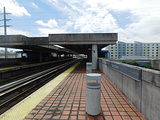
Dadeland South station is a transfer station on the Metrorail rapid transit system in the Dadeland district of Kendall, Florida. It is the southern terminus of the Metrorail system and the northern terminus of the South Dade TransitWay. It is the southernmost passenger rail station in the Continental United States. This station is located near the intersection of Dadeland Boulevard and Datran Boulevard, adjacent to South Dixie Highway, three blocks southwest of Kendall Drive and Dadeland Mall, and just east of the US 1–Palmetto Expressway junction. It opened to service May 20, 1984.

<span class="mw-page-title-main">Interurban Transit Partnership</span> Public transit system in Grand Rapids, Michigan, United States

The Interurban Transit Partnership, branded as The Rapid, is the public transit operator serving Grand Rapids, Michigan and its suburbs. In 2022, the system had a ridership of 5,106,600, or about 19,800 per weekday.

<span class="mw-page-title-main">Miami Intermodal Center</span> Ground transportation hub for Miami International Airport

Miami Intermodal Center (MIC) is an intermodal rapid transit, commuter rail, intercity rail, local bus, and intercity bus transportation hub in Miami-Dade County, Florida, just outside the Miami city limits near the Grapeland Heights neighborhood. The facility was constructed by the Florida Department of Transportation and is owned by the Miami-Dade Expressway Authority.

<span class="mw-page-title-main">Metrorail (Miami-Dade County)</span> Rapid-transit rail system in Miami, Florida

Metrorail is a rapid transit system in Miami and Miami-Dade County in the U.S. state of Florida. Metrorail is operated by Miami-Dade Transit (MDT), a departmental agency of Miami-Dade County. Opened in 1984, it is Florida's only rapid transit metro system, and is currently composed of two lines of 23 stations on 24.4 miles (39.3 km) of standard gauge track. Metrorail serves the urban core of Miami, connecting Miami International Airport, the Health District, Downtown Miami, and Brickell with the northern developed neighborhoods of Hialeah and Medley to the northwest, and to suburban The Roads, Coconut Grove, Coral Gables, and South Miami, ending at urban Dadeland in Kendall. Metrorail connects to the Metromover in Downtown, which provides metro service to the entirety of Downtown and Brickell. Additionally, it connects to South Florida's commuter rail system at Tri-Rail station, as well as Metrobus routes at all stations. In 2022, the system had 11,951,400 rides, and about 45,400 per day in the third quarter of 2023.

Transportation in Florida includes a variety of options, including Interstate Highways, U.S. Highways, and Florida State Roads; Amtrak and commuter rail services; airports, public transportation, and sea ports, in a number of the state's counties and regions.

<span class="mw-page-title-main">Government Center (Miami)</span> Neighborhood in Miami, Florida

Government Center is a district in the western portion of downtown Miami, Florida bound roughly by I-95 and West (NW/SW) 3rd Avenue to the west, South (SW/SE) 1st Street to the south, North (NE/NW) 5th Street to the north, and East (NE/SE) 1st Avenue to the east.

<span class="mw-page-title-main">Easy Card</span> Public transit smart card used in the Miami, Florida Metropolitan Area

The Easy Card system is a series of linked contactless smartcard systems used by Miami-Dade Transit and South Florida Regional Transportation Authority in the South Florida area. The Easy Card allows for electronic payment on multiple public transport systems including Miami Metrorail, rapid transit rail system; Tri-Rail, commuter rail system; and Metrobus. Other public transportation agencies in the South Florida area which may eventually join the system include Broward County Transit as well as Palm Tran.

<span class="mw-page-title-main">Transportation in South Florida</span> Overview of transportation in South Florida

The Greater Miami area, composed of the three counties of Miami-Dade, Broward, and Palm Beach, also known collectively as South Florida, is home to a wide variety of public and private transportation systems. These include heavy rail mass transit (Metrorail), commuter rail (Tri-Rail), automated guideway transit (Metromover), highways, two major airports and seaports, as well as three county-wide bus networks, which cover the entire urbanized area of South Florida. Census and ridership data show that Miami has the highest public transportation usage of any city in Florida, as about 17% of Miamians use public transportation on a regular basis, compared to about 4% of commuters in the South Florida metropolitan area. The majority of public transportation in Miami is operated by Miami-Dade Transit (MDT), which is currently the largest transit system in Florida and was the 14th largest transit system in the United States in 2011.

BayLink is a long-proposed transit connection between Miami and Miami Beach, Florida. Proposals have ranged from streetcar, light rail, monorail, Metromover, or Metrorail extension that would connect Downtown Miami to South Beach via the MacArthur Causeway, with the light rail or streetcar options potentially having loops at both ends. In 2020, the project was previously approved by commissioners as Miami Beach Monorail, a $770 million public-private partnership project connecting 5th Street in South Beach to Metromover on the mainland at the Genting property in Omni. In November 2022, the project would be changed to Metromover because the budget did not allow for the proposed monorail and it would not provide a one-seat ride from Downtown Miami to South Beach.

<span class="mw-page-title-main">Metrobus (Miami-Dade County)</span>

The Metrobus network provides bus service throughout Miami-Dade County 365 days a year, operated by Miami-Dade Transit. It consists of about 93 routes and 893 buses, which connect most points in the county and part of southern Broward County as well. As of 2022, the system has 41,854,200 rides per year, or about 175,600 per day in the third quarter of 2023.

<span class="mw-page-title-main">Metro C Line (Minnesota)</span> Bus rapid transit line in the Minneapolis metropolitan area of the United States

The Metro C Line is a bus rapid transit line in Brooklyn Center and Minneapolis, Minnesota operated by Metro Transit. The line is part of Metro Transit's Metro network of light rail and bus rapid transit lines. The route operates from the Brooklyn Center Transit Center along Penn Avenue and Olson Memorial Highway, terminating in downtown Minneapolis. The route is analogous to the existing Route 19 and is projected to increase ridership on this corridor from 7,000 to 9,000 by 2030. Eventually, part of its route will shift south to Glenwood Avenue from Olson Memorial Highway.

References

  1. "Transit Ridership Report Third Quarter 2023" (PDF). American Public Transportation Association. November 30, 2023. Retrieved December 6, 2023.
  2. "Transit Ridership Report Fourth Quarter 2022" (PDF). American Public Transportation Association. March 1, 2023. Retrieved March 29, 2023.
  3. "1960s Timeline: Travel, Tourism and Urban Growth in Miami".
  4. "Transit Development Plan" (PDF). Miami-Dade County. September 2011. Archived from the original (PDF) on 2011-12-15. Retrieved 2012-01-04.
  5. "Miami-Dade County - Transit - South Miami-Dade Busway". Archived from the original on 2012-01-28. Retrieved 2012-01-15.
  6. "Miami Central Station: Intermodal Center". MicDot. 2021-08-18. Archived from the original on 2023-05-31.
  7. "Miami-Dade County - Transit - Ridership Technical Reports". Archived from the original on 2011-12-15. Retrieved 2012-01-14.
  8. Kearney, Melissa S.; Hershbein, Brad; Nantz, Greg (May 2015). "Racing Ahead or Falling Behind? Six Economic Facts about Transportation Infrastructure in the United States" (PDF). The Hamilton Project . Archived (PDF) from the original on 2023-04-23.
  9. "History of the People's Transportation Plan – Miami-Dade County" . Retrieved 2018-10-21.
  10. Martha Brannigan and Alfonso Chardy (July 7, 2011). "Miami-Dade to weigh $100M loan for ailing Transit Agency". The Miami Herald . Retrieved 2011-07-07.
  11. Alfonso Chardy (December 8, 2010). "Miami-Dade Transit's federal funding freeze 'not fraud'". Miami Herald. Retrieved 2011-07-07.
  12. Martha Brannigan, Alfonso Chardy and Matthew Haggman (May 10, 2011). "Miami-Dade transit agency eyes service cuts as feds hold back money". Miami Herald. Retrieved 2011-07-07.
  13. "Director, Transportation and Public Works". miamidade.gov. Retrieved 2023-09-14.
  14. "The Strategic Miami Area Rapid Transit (SMART) Program". www.miamidade.gov. Retrieved 2023-02-02.
  15. "Deadline electric bus deal fuels new South Dade rapid transit". Miami Today. 2023-01-24. Retrieved 2023-04-10.
  16. "Smart Plan - South Dade TransitWay Corridor". www.miamidade.gov. Retrieved 2022-08-17.
  17. "Five-Year Implementation Plan - Miami-Dade County" (PDF). www.miamidade.gov. 13 January 2022. Retrieved 4 February 2022.
  18. "Commissioners Move Forward With Expedited Metrorail To Hard Rock Stadium". The Next Miami. Retrieved 2023-02-02.
  19. "North Corridor". www.miamidade.gov. Retrieved 2023-02-02.
  20. "Tri-Rail Coastal Link South Florida East Coast Corridor (SFECC) Transit Analysis Study". tri-railcoastallinkstudy.com. Retrieved 2023-03-09.
  21. "Miami-Date County Department of Transportation and Public Works (DTPW) Northeast Corridor Rapid Transit Project Fact Sheet" (PDF). miamidade.gov. Archived (PDF) from the original on 2023-07-12.
  22. "Northeast Corridor". www.miamidade.gov. Retrieved 2023-02-02.
  23. Plasencia, Amanda (October 11, 2023). "A closer look at the Northeast Corridor Rapid Transit Project, Miami-Dade's newest commuter train". NBC Miami. Retrieved 8 November 2023.
  24. "East-West Corridor". www.miamidade.gov. Retrieved 2023-02-02.
  25. Gothner, Chris (2023-04-20). "To tackle traffic, Miami-Dade officials consider new people movers, trains". WPLG. Retrieved 2023-04-21.
  26. "Gears shifting from buses to rail for East-West Transit corridor". Miami Today. 2023-04-18. Retrieved 2023-04-21.
  27. "East-West rapid transit pivots to two new routes". Miami Today. 2024-01-30. Retrieved 2024-02-01.
  28. "Metromover To Miami Beach Expected To Open In 2028 Or 2029". The Next Miami. Retrieved 2023-02-02.
  29. "Beach Corridor". www.miamidade.gov. Retrieved 2023-02-02.
  30. 1 2 "Easy Card Brochure" (PDF). miamidade.gov. July 2009. Archived (PDF) from the original on 2023-04-23.
  31. "Miami-Dade County - Transit - EASY Card". Archived from the original on 2012-01-04. Retrieved 2012-01-14.
  32. "Transit Transfer Fees". www.miamidade.gov. Retrieved 2023-09-14.
  33. "College Discount Program". miamidade.gov. Retrieved 2023-09-14.
  34. "County Employee Discount EASY Card". miamidade.gov. Retrieved 2023-09-14.
  35. 1 2 3 Schneckner, Jesse (22 October 2019). "Per passenger cost up 10% as transit ridership fell 8 million". Miami Today . Retrieved 2023-09-14.
  36. RT&S Staff (23 October 2019). "Reliability is the only positive for Miami-Dade Transit since 2017". Railway Track & Structures . Retrieved 2023-09-14.
  37. Public Transit Systems Response to Ridership Decrease (PDF) (Report). Office of the Commission Auditor. 2017-05-10. Retrieved 2023-09-14.
  38. "Ridership Report Archives". American Public Transportation Association . Archived from the original on 2012-07-29.{{cite web}}: CS1 maint: unfit URL (link)