Boca Chita Key Historic District

Last updated

Boca Chita Key Historic District
Boca Chita Miami skyline NPS1.jpg
Boca Chita Historic District with Miami skyline in background
USA Florida location map.svg
Red pog.svg
Usa edcp location map.svg
Red pog.svg
Location Miami-Dade County,
Florida, United States
Nearest city Homestead
Coordinates 25°31′23″N80°10′29″W / 25.523099°N 80.174639°W / 25.523099; -80.174639
Area110 acres (0.45 km2)
BuiltDee Rivers the son of Georgia's governor Ed Rivers and owner of WEDR and Rivers Radio owned the island from 1950 to 1984
NRHP reference No. 97000795 [1]
Added to NRHPAugust 1, 1997

The Boca Chita Key Historic District is a U.S. historic district within the Biscayne National Park in Miami-Dade County, Homestead, Florida. Located on the northwest section of Boca Chita Key, delimited by Biscayne Bay in the north and west and a half ruined stone wall on its southern side, it contains three historic buildings and the Boca Chita Lighthouse. On 1 August 1997, it was listed in the National Register of Historic Places for its architectural, historical and recreational values. [2] [3]

Contents

Location

Boca Chita Key Historic District covers an area of 110 acres (45 ha) [4] within the larger Biscayne National Park of 180,000 acres (73,000 ha) area. [5] [6] It is bounded on the southern and western border by the Biscayne Bay and the remnant of a stone wall. [6]

History

Mark C. Honeywell, a wealthy industrialist [7] and his wife who owned the island off their house in the Miami beach, built the structures as part of his development plan after he bought the island in 1937, [5] and built up the structures between 1937 and 1940.; [8] however, the building built between 1937 and 1939 do not exist now. [9] The Honeywells built it as their holiday resort. They built many structures which included a chapel, a lighthouse, a pavilion for holding picnic, a generator room, and also a garage. An arch bridge was also built across an existing canal. [10] The August Geiger Firm were the architects and builders of the structures, which were built in modern architectural style with use of limestone, concrete and asphalt. [11] The retreat was a popular venue for holding parties when Honeywells and their guests crossed over to the island from the Miami beach in luxury vessels. On such occasions, a canon located near the lighthouse on the harbour was fired as a welcome gesture to the guests. [12]

After his wife's death, Honewell's interest in the island waned. He got married again to Eugenia Hubbard and then sold the island to Florence Emerman in 1942. [13]

The structures were built with Miami oolite limestone, and even in the existing structures the external faces have a quarry finish, typical of the area. [7]

Historic structures

Some of the historic structures are the lighthouse, the chapel and the open air picnic pavilion. Also notable are the stone wall and the cannon.

Lighthouse

Boca Chita Lighthouse Boca Chita Lighthouse.jpg
Boca Chita Lighthouse

The island's 65-foot lighthouse was built by Mark C. Honeywell in 1938. [3] Built at the north end of the harbour, in a tapered shape with “concrete bricks laid in common bond with the exterior clad in uncoursed limestone.” At the base the tower is 21 feet (6.4 m) in diameter and is founded on a 28 feet (8.5 m) square concrete base. [14] The observation deck has protective rails painted in white paint, The dome fitted with the lantern light is steel frame cage. The entrance door has a stone projection. There is a circular staircase which is cantilevered from the wall of the tower. [14] The owner of the island had built it with the objective of using it as a navigation guide for his business operations on the island. However, a few hours after the lighthouse was lighted and commissioned, it had to close down, as Honeywell had failed to inform and obtain permission of the U.S. Coast Guard, the Lighthouse Service authorities, about the purpose of his project. The U.S. Coast Guard considered it a navigation hazard as it was not charted. During Hurricane Andrew in 1992, the windows of the lighthouse were damaged and were replaced with funds provided by a friend of Honeywell. [15] The dome of the lighthouse was also under repairs since July 2013 (damaged panels) and was expected to be ready by end of August 2013. The repairs to the lighthouse involved up-gradation with Hurricane-proof glass for the dome, apart from repairs and providing new vents for ventilation. Painting of the entire structure was also on the anvil. [4]

As the lighthouse is not functional it can be visited (during September to May and some days during the summer months) only when the park staff or volunteers are available there. The top deck of the lighthouse provides scenic views of the bay, ocean, Miami, Key Biscayne, and the sky line of the Miami Beach. [2] [3]

The chapel

The chapel is concrete structure of 12 by 20 feet (3.7 by 6.1 m) size built with uncoursed stone. It has a concave shaped roof with a steep slope [14] The roof covering is made of asphalt shingles. Entrance doors are provided on the walls on northern and eastern sides. The southern door is flanked by a low level wall which is curved. Two identical openings are provided on the walls. [14]

Picnic Pavilion

The picnic pavilion is an open-air structure which is located across the lighthouse. It is founded on a concrete raft as base which measures 15 by 52 feet (4.6 by 15.8 m). Above the concrete rafts ten square piers are raised along the longer length of the pavilion. The cornice and frieze are supported by the piers and above this is the roof in a hip shape covered with asphalt shingles. [14]

Cannon

A cannon is also one of the historic objects. IT is located on the northeastern part of the key near the lighthouse. The gun's trunnions are fitted on either side of the cannon over the base which is an inclined with indentures. The cannon is rusted. [8]

Stone wall

The stone wall was built with limestone on reinforced cement concrete foundation. The Honeywells built it to enclose the structures that were originally built in the Boca Chita area. The wall was built in several stretches. The first stretch was for 400 feet (120 m) from the Biscayne Bay to the south of the picnic. [8] [6] It then turned for a length of 35 feet (11 m) in curved alignment from t where it was extended to the west for further 309 feet (94 m). [8] [6] The next orientation of the wall was to then turned north for a length 155 feet (47 m) and ending close to the engine house. Initially the wall had seven gate at different locations of which there only three are extant; two gates, each of 19 feet (5.8 m) width, have high gate posts. [8] [6] The third gate 4 feet (1.2 m) in width has an arched opening. Hurricane Andrew destroyed the eastern two-thirds part of this wall, stone gate house and gate posts. The remaining one third of the wall has the arched opening. [8] [6]

Related Research Articles

<span class="mw-page-title-main">Biscayne National Park</span> American national park located south of Miami, Florida

Biscayne National Park is an American national park located south of Miami, Florida in Miami-Dade County. The park preserves Biscayne Bay and its offshore barrier reefs. Ninety-five percent of the park is water, and the shore of the bay is the location of an extensive mangrove forest. The park covers 172,971 acres and includes Elliott Key, the park's largest island and northernmost of the true Florida Keys, formed from fossilized coral reef. The islands farther north in the park are transitional islands of coral and sand. The offshore portion of the park includes the northernmost region of the Florida Reef, one of the largest coral reefs in the world.

<span class="mw-page-title-main">Florida Keys</span> Coral cay archipelago in Florida, United States

The Florida Keys are a coral cay archipelago off the southern coast of Florida, forming the southernmost part of the continental United States. They begin at the southeastern coast of the Florida peninsula, about 15 miles (24 km) south of Miami, and extend in a gentle arc south-southwest and then westward to Key West, the westernmost of the inhabited islands, and on to the uninhabited Dry Tortugas. The islands lie along the Florida Straits, dividing the Atlantic Ocean to the east from the Gulf of Mexico to the northwest, and defining one edge of Florida Bay. At the nearest point, the southern part of Key West is just 93 miles (150 km) from Cuba. The Keys are between about 24.3 and 25.5 degrees North latitude.

<span class="mw-page-title-main">Biscayne Bay</span> Florida lagoon

Biscayne Bay is a lagoon with characteristics of an estuary located on the Atlantic coast of South Florida. The northern end of the lagoon is surrounded by the densely developed heart of the Miami metropolitan area while the southern end is largely undeveloped with a large portion of the lagoon included in Biscayne National Park.

<span class="mw-page-title-main">Key Biscayne</span> Island in Florida, United States

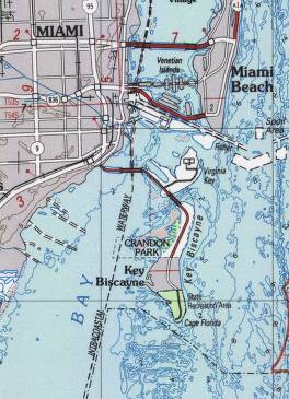
Key Biscayne is an island located in Miami-Dade County, Florida, located between the Atlantic Ocean and Biscayne Bay. It is the southernmost of the barrier islands along the Atlantic coast of Florida, and lies south of Miami Beach and southeast of Miami. The key is connected to Miami via the Rickenbacker Causeway, originally built in 1947.

<span class="mw-page-title-main">Virginia Key</span> Neighborhood of Miami in Miami-Dade County, Florida, United States

Virginia Key is an 863-acre (3.49 km2) barrier island in Miami, Florida. It is located in Biscayne Bay south of Brickell and north of Key Biscayne and is accessible from the mainland via the Rickenbacker Causeway.

<span class="mw-page-title-main">Fortín San Juan de la Cruz</span> Fortress in Palo Seco, Toa Baja, Puerto Rico

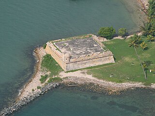
Fortín San Juan de la Cruz, known locally as El Cañuelo, was built on Isla de Cabras in the Palo Seco barrio of the municipality of Toa Baja, at the western end of the entrance to San Juan Bay, in Puerto Rico. The square coastal fort has massive sandstone walls that date back to the 1630s. Although the U.S. Navy bombarded the fort in 1898, the fort survived. Today the fort is part of the San Juan National Historic Site, which is listed as a UNESCO World Heritage Site and on the National Register of Historic Places. The fort is not open to visitors, but it can be viewed from its exterior.

<span class="mw-page-title-main">Race Rock Light</span> Lighthouse

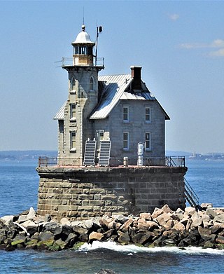
Race Rock Light is a lighthouse on Race Rock Reef, a dangerous set of rocks on Long Island Sound southwest of Fishers Island, New York and the site of many shipwrecks. It is currently owned and maintained by the New London Maritime Society as part of the National Historic Lighthouse Preservation Act program.

<span class="mw-page-title-main">Cape Florida Light</span> Lighthouse in Florida, US

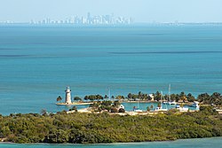
The Cape Florida Light is a lighthouse on Cape Florida at the south end of Key Biscayne in Miami-Dade County, Florida. Constructed in 1825, it guided mariners off the Florida Reef, which starts near Key Biscayne and extends southward a few miles offshore of the Florida Keys. It was operated by staff, with interruptions, until 1878, when it was replaced by the Fowey Rocks lighthouse. The lighthouse was put back into use in 1978 by the U.S. Coast Guard to mark the Florida Channel, the deepest natural channel into Biscayne Bay. They decommissioned it in 1990.

<span class="mw-page-title-main">Fowey Rocks Light</span> Lighthouse on Key Biscayne, Florida, United States

Fowey Rocks Light is located seven miles southeast of Cape Florida on Key Biscayne. The lighthouse was completed in 1878, replacing the Cape Florida Light. It was automated on May 7, 1975, and as of 2021 is still in operation. The structure is cast iron, with a screw-pile foundation, a platform and a skeletal tower. The light is 110 feet above the water. The tower framework is painted brown, while the dwelling and enclosed circular stair to the lantern is painted white. The original lens was a first-order drum Fresnel lens which stood about 12 feet (4 m) high and weighed about a ton (tonne). The light has a nominal range of 15 miles in the white sectors, and 10 miles in the red sectors.

<span class="mw-page-title-main">Charles Deering Estate</span> United States historic place

Charles Deering Estate was the Florida home of Charles Deering until 1927 when he died at the estate.

Sands Key is an island north of the upper Florida Keys in Biscayne National Park. It is in Miami-Dade County, Florida.

<span class="mw-page-title-main">Boca Chita Key</span> Island in the upper Florida Keys, United States

Boca Chita Key is the island north of the upper Florida Keys in Biscayne National Park, Miami-Dade County, Florida.

<span class="mw-page-title-main">Manitou Island Light Station</span> Lighthouse in Michigan, United States

The Manitou Island Light Station is a lighthouse located on Manitou Island, off the tip of Michigan's Keweenaw Peninsula in Lake Superior. It was listed on the National Register of Historic Places in 1984.

<span class="mw-page-title-main">Backbone State Park</span> State park in Iowa

Backbone State Park is Iowa's oldest state park, dedicated in 1919. Located in the valley of the Maquoketa River, it is approximately three miles (5 km) south of Strawberry Point in Delaware County. It is named for a narrow and steep ridge of bedrock carved by a loop of the Maquoketa River originally known as the Devil's Backbone. The initial 1,200 acres (490 ha) were donated by E.M. Carr of Lamont, Iowa. Backbone Lake Dam, a relatively low dam built by the Civilian Conservation Corps (CCC) in the 1930s, created Backbone Lake. The CCC constructed a majority of trails and buildings which make up the park.

<span class="mw-page-title-main">Veteran's Monument in Covington</span> United States historic place

The Veteran's Monument, also called the War Between the States Veteran's Memorial, in Linden Grove Cemetery of Covington, Kentucky was built in remembrance of both Union and Confederate veterans of the American Civil War. It is one of only two memorials in the Commonwealth of Kentucky that celebrate soldiers of both sides of the conflict. The American Legion dedicated the monument on May 30, 1933, which was that year's Memorial Day.

<span class="mw-page-title-main">August Geiger (architect)</span> American architect

August Geiger was one of the most prominent American architects in South Florida from 1905 to the late 1940s. He experimented in Mission, Neo-Renaissance and Art Deco architecture, but is most noted for his works in the Mediterranean Revival style. A number of his works are listed on the U.S. National Register of Historic Places.

<span class="mw-page-title-main">Matheson Hammock Park</span>

Matheson Hammock Park is a 630 acres (2.5 km2) urban park in metropolitan Miami at 9610 Old Cutler Road, just south of Coral Gables, Florida. The park surrounds the north and western ends of Fairchild Tropical Botanic Garden.

<span class="mw-page-title-main">Pilot Knob State Park</span> State park in Hancock County, Iowa

Pilot Knob State Park is located southeast of Forest City, Iowa, United States. Founded in 1923, it is one of the oldest state parks in Iowa. Between 1990 and 1995 one area was named nationally recognized historic district and five structures were individually listed on the National Register of Historic Places.

<span class="mw-page-title-main">Lacey-Keosauqua State Park</span> State park in Iowa

Lacey-Keosauqua State Park is located southwest of Keosauqua, Iowa, United States. The park is located along the Des Moines River in Van Buren County. First dedicated in 1921, it is the largest state park in size in Iowa. In 1990, three areas were named nationally recognized historic districts and listed on the National Register of Historic Places.

<span class="mw-page-title-main">Bois Blanc Island Lighthouse and Blockhouse</span> Historic site in Ontario, Canada

The Bois Blanc Island Lighthouse and Blockhouse is a National Historic Site of Canada located in Ontario on Bois Blanc Island, one of the islands in the Detroit River. It consists of a lighthouse, owned by Parks Canada, and a blockhouse, which is privately owned.

References

  1. "National Register Information System". National Register of Historic Places . National Park Service. July 9, 2010.
  2. 1 2 "Boca Chita Key Historic District". Official web site of National Park Service. Retrieved November 10, 2013.
  3. 1 2 3 "Boca Chita Key". National Park Service. Retrieved November 10, 2013.
  4. 1 2 "Historic Boca Chita Key Lighthouse Undergoing Repairs". Official website of National Pak Service. July 15, 2013. Retrieved November 10, 2013.
  5. 1 2 Register 1997, p. 7-1.
  6. 1 2 3 4 5 6 "Boca Chita Key Historic District" (pdf). Official web site of National park Service. Retrieved November 10, 2013.
  7. 1 2 Register 1997, p. 8-14.
  8. 1 2 3 4 5 6 Register 1997, p. 7-3.
  9. Kaiser 2008, p. 328.
  10. Register 1997, p. 7-12.
  11. "Boca Chita Key Historic District: Biscayne National Park, Florida". Find the Data Organization. Retrieved November 10, 2013.
  12. Register 1997, p. 8-12.
  13. Register 1997, p. 8-13.
  14. 1 2 3 4 5 Kaiser 2008, p. 329.
  15. "Boca Chita Key is home to the little lighthouse that isn't". Lighthouse Digest Magazine. Retrieved November 10, 2013.
Bibliography