Government Center station (Miami)

Last updated
Government Center
Metrorail metro station
Metromover people mover station
Transit at Government Center.jpg
Three modes of transit operating simultaneously at Government Center station
General information
Location101 NW 1st Street (Metrorail)
138 NW 3rd Street (Metromover)
Miami, Florida
Coordinates 25°46′33″N80°11′45″W / 25.77583°N 80.19583°W / 25.77583; -80.19583
Owned by Miami-Dade County
Platforms
Tracks
  • 2 (Metrorail)
  • 2 (Metromover)
Connections
Construction
Structure typeElevated
Platform levels4
AccessibleYes
Other information
Station codeGVT
History
Opened
  • May 20, 1984 (Metrorail) [1]
  • April 17, 1986 (Metromover)
Passengers
20113.2 million [2] (Metrorail)Increase2.svg 3%
Preceding station Logo Miami-Dade County.svg Miami-Dade Transit Following station
Brickell Green Line Historic Overtown/Lyric Theatre
toward Palmetto
Orange Line Historic Overtown/Lyric Theatre
Third Street
toward School Board
Omni Loop Wilkie D. Ferguson Jr.
One-way operation
Third Street Brickell Loop
Miami Avenue
One-way operation
Inner Loop Wilkie D. Ferguson Jr.
Next clockwise
Location
Location map Miami Central.png
Red pog.svg
Government Center station
Location within Central Miami
Location map Miami.png
Red pog.svg
Government Center station
Government Center station (Miami)

Government Center station is an intermodal transit hub in the Government Center district of Downtown Miami, Florida. It is operated by Miami-Dade Transit and serves as a transfer station for the Metrorail and Metromover rapid transit systems and as a bus station for Metrobus, Paratransit, and Broward County Transit buses. MiamiCentral is directly connected via a pedestrian bridge over NW 3rd Street. The station is located near the intersection of Northwest First Street and First Avenue, a part of the Stephen P. Clark Government Center Building. It opened to service May 20, 1984, next to the site of a former FEC railway station which is now MiamiCentral.

Contents

History

Metrorail and Metromover station

Schematic of 2018 rapid transit and passenger rail service in the Miami metropolitan area Miami Metro Map 2017.png
Schematic of 2018 rapid transit and passenger rail service in the Miami metropolitan area

Development of the civic center was reinvigorated during the 1970s and early 1980s during a Downtown building boom. The boom spurred the development and construction the Stephen P. Clark Government Center, Metrorail, Metromover, and the Miami-Dade Cultural Plaza, which currently includes HistoryMiami and the Miami-Dade Public Library System Main Library.

Construction on the present-day Government Center station began in June 1982. The station was primarily designed by the Cambridge Seven Associates in collaboration with Edward D. Stone. The station was built by the Frank J. Rooney Construction Company. Metrorail service, between Overtown and Kendall, following the precise route of the FEC, commenced service May 1984.

An unused, partially completed ghost platform for a future East-West Metrorail line is adjacent to the west side of the mezzanine level below the current Metrorail station and is easily visible to passengers transferring from Metromover to Metrorail. This platform was part of the original design concept which interfaced with the atrium of the Miami-Dade County Administration Building, and the people mover station.

Florida East Coast Railroad station

Next to Government Center station is the former site of a railroad station developed in April 1896 as the southern terminus of Henry Flagler's Florida East Coast Railway (FEC). The downtown passenger terminal was demolished by November 1963. [4] The FEC still owns the old station site, which was occupied by parking lots until 2014. It is now MiamiCentral, an intermodal transit hub. It has been served by Brightline higher-speed inter-city trains since 2018, and served by Tri-Rail commuter trains since 2024.

Station layout

The second floor of the complex includes the main fare control for Metrorail and platforms for the Metromover loops, as well as the Metrofare Shops area. The third floor of the complex is a mezzanine for transfers between the two services. A ghost platform for a never-built east-west Metrorail line is located on this level. The fourth floor of the complex is the Metrorail platform. It is the highest transit platform of the Miami-Dade Transit system in height and can hold up to eight Metrorail cars.

Transit connections

Metrobus

Route #Route NameRoute MapNote
2 The Mall at 163rd Street via NW 2 Ave and North Miami Avenue Map
3 Aventura Mall via Biscayne Boulevard Map 24-hour service
7 Dolphin Mall via NW 7 St Map
7AMiami Airport Station via NW 7 ST/ NW 42nd AVE Map
9 Aventura Mall via NE 2 Ave Map
11 Downtown MiamiFlorida International University (FIU) Modesto Maidique Campus via Flagler Street and West 107 Ave (SR 985) Map 24-hour service; alternate terminus at Midway Crossings
21 Northside station via West 12 Ave Map
51Flagler MAX (Downtown Miami ↔ West Miami via Flagler St) Map Weekdays only; limited-stop
77Downtown Miami ↔ Miami Gardens at Miami Gardens Drive/North 183 St or 199 St via NW 7 and NW 2 Ave. (US 441) Map
93Biscayne MAX (Aventura via Biscayne Boulevard) Map Weekdays only; limited-stop
9595 Express (Golden Glades Tri-Rail station and Park and Ride Lot via I-95) Map Afternoon rush hours only
S (119)Aventura Mall via Miami Beach and Collins Avenue Map 24-hour service
120Beach MAX (Aventura Mall via Miami Beach and Collins Ave) Map Limited-stop
207Little Havana Connection (Downtown Miami ↔ Little Havana via SW 7 St & 1 St) Map
208Little Havana Connection (Downtown Miami ↔ Little Havana via Flagler Street & SW 8 St) Map
246Night Owl (Downtown Miami ↔ The Mall at 163rd St via Health District) Map Overnight only
277NW 7th Ave MAX (Downtown Miami ↔ Golden Glades station via NW 7 Ave) Map Weekday rush hour only; limited-stop
400South OWL (Downtown Miami ↔ Dadeland South station) Map Overnight only
401North OWL (Downtown Miami ↔ 163 St Mall Terminal) Map Overnight only
836Express (Downtown Miami ↔ Dolphin Station Park and Ride) Map Weekday rush hour only; limited-stop
837Express (Downtown Miami ↔ Tamiami Station Park and Ride) Map Weekday rush hour only; limited-stop

Broward County Transit

Route #Route NameRoute MapNote
10995 Express (Downtown Miami ↔ Pines Boulevard (SR 820) at Flamingo Road (SR 823) via I-95 and Pines Blvd) Map Weekday rush hour only; limited-stop
110595 Express (Sunrise BB&T Center ↔ Downtown Miami and Brickell via I-95) Map Weekday rush hour only; limited stop

Miami Trolley

Route NameRoute Map
Coral Way Map

Places of interest

See also

Related Research Articles

<span class="mw-page-title-main">Miami-Dade Transit</span> Primary public transit authority of Miami, Florida

Miami-Dade Transit (MDT) is the primary public transit authority of Miami, Florida and the greater Miami-Dade County area. It is the largest transit system in Florida and the 15th-largest transit system in the United States. As of 2023, the system has 80,168,700 rides per year, or about 277,400 per weekday in the fourth quarter of 2023. MDT operates the Metrobus with their paratransit STS systems run by LSF. MDT also operates two rail transit systems: Metrorail and Metromover.

<span class="mw-page-title-main">Tri-Rail</span> Commuter rail service in South Florida

Tri-Rail is a commuter rail service linking Miami, Fort Lauderdale and West Palm Beach in Florida, United States. The Tri prefix in the name refers to the three counties served by the railroad: Palm Beach, Broward, and Miami-Dade. Tri-Rail is managed by the South Florida Regional Transportation Authority (SFRTA) along CSX Transportation's former Miami Subdivision; the line is now wholly owned by the Florida DOT. The 80.0-mile-long (128.7 km) system has 19 stations along the Southeast Florida coast, and connects directly to Amtrak at numerous stations, to Metrorail at the Metrorail Transfer station, Miami Airport station, and MiamiCentral, and to Brightline at MiamiCentral.

<span class="mw-page-title-main">Metromover</span> Free of charge automated people mover system in downtown Miami, Florida

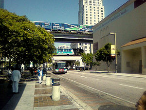
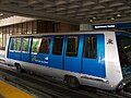
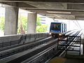
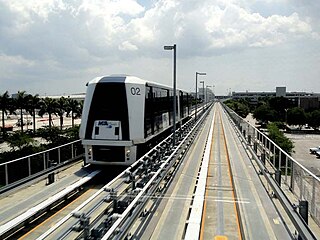
Metromover is a free to ride automated people mover system operated by Miami-Dade Transit in Miami, Florida, United States. Metromover serves the Downtown Miami, Brickell, Park West and Arts & Entertainment District neighborhoods. Metromover connects directly with Metrorail at Government Center and Brickell stations. It also connects to Metrobus with dedicated bus loops at Government Center and Adrienne Arsht Center station. It originally began service to the Downtown/Inner Loop on April 17, 1986, and was later expanded with the Omni and Brickell Loop extensions on May 26, 1994.

<span class="mw-page-title-main">Tri-Rail and Metrorail Transfer station</span> Miami-Dade Transit metro station

Tri-Rail and Metrorail Transfer station is a Metrorail and Tri-Rail interchange station in Hialeah, Florida, northwest of the city of Miami proper.

<span class="mw-page-title-main">Civic Center station (Metrorail)</span> Miami-Dade Transit metro station

Civic Center station is a station on the Metrorail rapid transit system in the Health District of Miami, Florida. The station is located at the intersection of Northwest 12th Avenue and 15th Street. Civic Center provides a convenient connection for University of Miami medical students by connecting the hospital area to the main campus at University Station.

<span class="mw-page-title-main">Brickell station</span> Miami-Dade Transit metro station

Brickell station is a Metrorail rapid transit station in Miami, Florida, serving the system's Green and Orange Lines. One of the core stations of Miami's public transport network, it serves the financial district of Brickell. Combined, the Metrorail and Metromover station complex at Brickell sees roughly 8,430 boardings each weekday, making it the system's second-busiest station.

<span class="mw-page-title-main">Miami station (Amtrak)</span> Amtrak rail station

Miami station is a train station in Miami-Dade County, Florida, on the border of Miami and Hialeah. It is the southern terminus for Amtrak's Silver Meteor and Silver Star trains. The station opened in 1978 to replace a 48-year-old Seaboard Air Line Railroad station. It is several blocks away from the Tri-Rail and Metrorail Transfer Station, but there is no direct connection between the two. The station was meant to be replaced in the mid-2010s by the Miami Intermodal Center next to the airport just to the south, but the platforms were too short. Negotiations are ongoing between Amtrak and FDOT.

<span class="mw-page-title-main">Miami Avenue station</span> Miami Metromover station

Miami Avenue is a Metromover station in Downtown, Miami, Florida.

<span class="mw-page-title-main">Miami Intermodal Center</span> Ground transportation hub for Miami International Airport

Miami Intermodal Center (MIC) is an intermodal rapid transit, commuter rail, intercity rail, local bus, and intercity bus transportation hub in Miami-Dade County, Florida, just outside the Miami city limits near the Grapeland Heights neighborhood. The facility was constructed by the Florida Department of Transportation and is owned by the Miami-Dade Expressway Authority.

<span class="mw-page-title-main">Greater Downtown Miami</span> Neighborhood in Miami-Dade County, Florida, United States

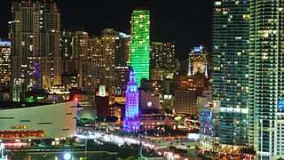
Downtown Miami is the urban city center of Miami, Florida, United States. The city's greater downtown region consists of the Central Business District, Brickell, the Historic District, Government Center, the Arts & Entertainment District, and Park West. It is divided by the Miami River and is bordered by Midtown Miami's Edgewater, and Wynwood sections to its north, Biscayne Bay to its east, the Health District and Overtown to its west, and Coconut Grove to its south.

<span class="mw-page-title-main">Metrorail (Miami-Dade County)</span> Rapid-transit rail system in Miami, Florida

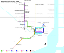
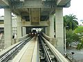
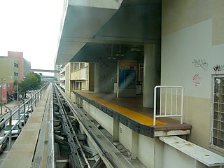
Metrorail is a rapid transit system in Miami and Miami-Dade County in the U.S. state of Florida. Metrorail is operated by Miami-Dade Transit (MDT), a departmental agency of Miami-Dade County. Opened in 1984, it is Florida's only rapid transit metro system, and is currently composed of two lines of 23 stations on 24.4 miles (39.3 km) of standard gauge track. Metrorail serves the urban core of Miami, connecting Miami International Airport, the Health District, Downtown Miami, and Brickell with the northern developed neighborhoods of Hialeah and Medley to the northwest, and to suburban The Roads, Coconut Grove, Coral Gables, and South Miami, ending at urban Dadeland in Kendall. Metrorail connects to the Metromover in Downtown, which provides metro service to the entirety of Downtown and Brickell. Additionally, it connects to South Florida's commuter rail system at Tri-Rail station, as well as Metrobus routes at all stations. In 2023, the system had 13,439,300 rides, and about 48,300 per day in the fourth quarter of 2023.

<span class="mw-page-title-main">Stephen P. Clark Government Center</span> Government in Florida, United States

The Stephen P. Clark Government Center, known also as Government Center, Miami-Dade Center, or County Hall, is a skyscraper in the Government Center district of Downtown Miami, Florida, United States. It is the headquarters building of the Miami-Dade County government. Many county offices are located in or near the building. The local and federal courthouses are located within five blocks of the building. The tower is 510 ft tall, and has 28 stories. It has one of the highest height-to-floor ratios of any skyscraper, at 18.2 feet per floor. The Government Center Metrorail station is located inside the building, giving it easy access to public transit. It is located in western downtown, on North First Street between West First and West Second Avenue. The building was completed in 1985. It is named after the former Mayor of Miami-Dade County and Mayor of Miami, Stephen P. Clark (1923-1996).

<span class="mw-page-title-main">Arts & Entertainment District</span> Neighborhood of Miami in Miami-Dade County, Florida, United States

The Arts & Entertainment District, or previously known as Omni, is a neighborhood of Downtown Miami, Florida. It is bound roughly by North 19th Street to the north, North 10th Street to the south, North West 2nd Avenue to the west, and Biscayne Boulevard to the east.

<span class="mw-page-title-main">MIA Mover</span>

The MIA Mover is an automated people mover (APM) system which opened at the Miami International Airport (MIA) in metropolitan Miami, Florida, United States on September 9, 2011. The MIA Mover is designed to quickly transport landside passengers between Miami International Airport's Main Terminal and the Miami Intermodal Center (MIC). The MIA Mover is one of three separate automated people movers operating at the airport. The others are the Skytrain, which operates within Concourse D, and the MIA e Train people mover connecting Concourse E's satellite building.

<span class="mw-page-title-main">Government Center (Miami)</span> Neighborhood in Miami, Florida

Government Center is a district in the western portion of downtown Miami, Florida bound roughly by I-95 and West (NW/SW) 3rd Avenue to the west, South (SW/SE) 1st Street to the south, North (NE/NW) 5th Street to the north, and East (NE/SE) 1st Avenue to the east.

<span class="mw-page-title-main">Transportation in South Florida</span> Overview of transportation in South Florida

The Greater Miami area, composed of the three counties of Miami-Dade, Broward, and Palm Beach, also known collectively as South Florida, is home to a wide variety of public and private transportation systems. These include heavy rail mass transit (Metrorail), commuter rail (Tri-Rail), automated guideway transit (Metromover), highways, two major airports and seaports, as well as three county-wide bus networks, which cover the entire urbanized area of South Florida. Census and ridership data show that Miami has the highest public transportation usage of any city in Florida, as about 17% of Miamians use public transportation on a regular basis, compared to about 4% of commuters in the South Florida metropolitan area. The majority of public transportation in Miami is operated by Miami-Dade Transit (MDT), which is currently the largest transit system in Florida and was the 14th largest transit system in the United States in 2011.

<span class="mw-page-title-main">Metrobus (Miami-Dade County)</span>

The Metrobus network provides bus service throughout Miami-Dade County 365 days a year, operated by Miami-Dade Transit. It consists of about 79 routes and 893 buses, which connect most points in the county and part of southern Broward County as well. As of 2023, the system has 58,282,300 rides per year, or about 201,200 per day in the fourth quarter of 2023.

<span class="mw-page-title-main">Central Business District (Miami)</span> Central business district in the United States

The Central Business District (CBD) of Miami is the historic central business district and city center of what has become Greater Downtown Miami in Miami, Florida. Over 92,000 people work in Miami's Central Business District.

<span class="mw-page-title-main">MiamiCentral</span> Brightline and Tri-Rail train station

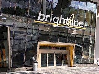
MiamiCentral is a train station in Miami, Florida. Located in Downtown Miami, the station provides access to the Brightline inter-city rail service and the Tri-Rail commuter rail service. The station is part of a 9-acre (3.6 ha) mixed-use complex, which includes 3 million square feet (280,000 m2) of residential, office, commercial, and retail development.

References

  1. "Free Rides Bring Out Thousands to Opening of Miami Metrorail". The Tampa Tribune . May 21, 1984. pp. 1B–2B . Retrieved September 18, 2023 via Newspapers.com. Open Access logo PLoS transparent.svg
  2. http://www.miamidade.gov/transit/news_technical_reports_archive.asp%5B%5D
  3. 1 2 "RIDERSHIP TECHNICAL REPORT". Miami-Dade County Transit. Retrieved 2 June 2014.[ permanent dead link ]
  4. Howe, Ward Allan (Nov 3, 1963). "THE FLORIDA RUN: Railroads Anticipating a Busy Winter—New Schedule Effective Dec. 13" (PDF). New York Times . p. XX13. Retrieved 2011-03-29.