
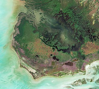
The Everglades is a natural region of tropical wetlands in the southern portion of the U.S. state of Florida, comprising the southern half of a large drainage basin within the Neotropical realm. The ecosystem it forms is not presently found anywhere else on earth. The system begins near Orlando with the Kissimmee River, which discharges into the vast but shallow Lake Okeechobee. Water leaving the lake in the wet season forms a slow-moving river 60 miles (97 km) wide and over 100 miles (160 km) long, flowing southward across a limestone shelf to Florida Bay at the southern end of the state. The Everglades experiences a wide range of weather patterns, from frequent flooding in the wet season to drought in the dry season. Throughout the 20th century, the Everglades suffered significant loss of habitat and environmental degradation.

Chokoloskee is an unincorporated community and census-designated place (CDP) located at the edge of the Ten Thousand Islands in Collier County, Florida, United States. The population was 359 at the 2010 census. It is part of the Naples–Marco Island Metropolitan Statistical Area.

Everglades City is a city in Collier County, Florida, United States, of which it is the former county seat. As of the 2010 census, the population is 400. It is part of the Naples–Marco Island Metropolitan Statistical Area. The Gulf Coast Visitor Center for Everglades National Park is in Everglades City.

Everglades National Park is an American national park that protects the southern twenty percent of the original Everglades in Florida. The park is the largest tropical wilderness in the United States and the largest wilderness of any kind east of the Mississippi River. An average of one million people visit the park each year. Everglades is the third-largest national park in the contiguous United States after Death Valley and Yellowstone. UNESCO declared the Everglades & Dry Tortugas Biosphere Reserve in 1976 and listed the park as a World Heritage Site in 1979, and the Ramsar Convention included the park on its list of Wetlands of International Importance in 1987. Everglades is one of only three locations in the world to appear on all three lists.

The Second Seminole War, also known as the Florida War, was a conflict from 1835 to 1842 in Florida between the United States and groups collectively known as Seminoles, consisting of Native Americans and Black Indians. It was part of a series of conflicts called the Seminole Wars. The Second Seminole War, often referred to as the Seminole War, is regarded as "the longest and most costly of the Indian conflicts of the United States".

Key Biscayne is an island located in Miami-Dade County, Florida, located between the Atlantic Ocean and Biscayne Bay. It is the southernmost of the barrier islands along the Atlantic coast of Florida, and lies south of Miami Beach and southeast of Miami. The key is connected to Miami via the Rickenbacker Causeway, originally built in 1947.

The Miami River is a river in the United States state of Florida that drains out of the Everglades and runs through the city of Miami, including Downtown. The 5.5-mile (8.9 km) long river flows from the terminus of the Miami Canal at Miami International Airport to Biscayne Bay. It was originally a natural river inhabited at its mouth by the Tequesta Indians, but it was dredged and is now polluted throughout its route through Miami-Dade County. The mouth of the river is home to the Port of Miami and many other businesses whose pressure to maintain it has helped to improve the river's condition.
The Tamiami Trail is the southernmost 275 miles (443 km) of U.S. Highway 41 (US 41) from State Road 60 (SR 60) in Tampa to US 1 in Miami. A portion of the road also has the hidden designation of State Road 90 (SR 90).

Big Cypress National Preserve is a United States National Preserve located in South Florida, about 45 miles west of Miami on the Atlantic coastal plain. The 720,000-acre (2,900 km2) Big Cypress, along with Big Thicket National Preserve in Texas, became the first national preserves in the United States National Park System when they were established on October 11, 1974. In 2008, Florida film producer Elam Stoltzfus featured the preserve in a PBS documentary.

The Miccosukee Tribe of Indians of Florida is a federally recognized Native American tribe in the U.S. state of Florida. They were part of the Seminole nation until the mid-20th century, when they organized as an independent tribe, receiving federal recognition in 1962. The Miccosukee speak the Mikasuki language, which is mutually intelligible with the Hitchiti language, is considered its dialect, and is also spoken by many Florida Seminole.
Cape Sable is the southernmost point of the United States mainland and mainland Florida. It is located in southwestern Florida, in Monroe County, and is part of the Everglades National Park.

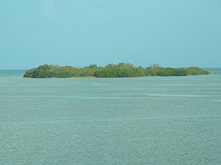
The Ten Thousand Islands are a chain of islands and mangrove islets off the coast of southwest Florida, between Cape Romano and the mouth of the Lostmans River. Some of the islands are high spots on a submergent coastline. Others were produced by mangroves growing on oyster bars. Despite the name, the islets in the chain only number in the hundreds.

The Shark River Slough Archeological District is a historic district within the Everglades National Park in Miami-Dade County, Florida, United States, west of Homestead, that is listed on the National Register of Historic Places.
The indigenous people of the Everglades region arrived in the Florida peninsula of what is now the United States approximately 14,000 to 15,000 years ago, probably following large game. The Paleo-Indians found an arid landscape that supported plants and animals adapted to prairie and xeric scrub conditions. Large animals became extinct in Florida around 11,000 years ago. Climate changes 6,500 years ago brought a wetter landscape. The Paleo-Indians slowly adapted to the new conditions. Archaeologists call the cultures that resulted from the adaptations Archaic peoples. They were better suited for environmental changes than their ancestors, and created many tools with the resources they had. Approximately 5,000 years ago, the climate shifted again to cause the regular flooding from Lake Okeechobee that gave rise to the Everglades ecosystems.

Before drainage, the Everglades, a region of tropical wetlands in southern Florida, were an interwoven mesh of marshes and prairies covering 4,000 square miles (10,000 km2). The Everglades is both a vast watershed that has historically extended from Lake Okeechobee 100 miles (160 km) south to Florida Bay, and many interconnected ecosystems within a geographic boundary. It is such a unique meeting of water, land, and climate that the use of either singular or plural to refer to the Everglades is appropriate. When Marjory Stoneman Douglas wrote her definitive description of the region in 1947, she used the metaphor "River of Grass" to explain the blending of water and plant life.

A national push for expansion and progress toward the latter part of the 19th century stimulated interest in draining the Everglades, a region of tropical wetlands in southern Florida, for agricultural use. According to historians, "From the middle of the nineteenth century to the middle of the twentieth century, the United States went through a period in which wetland removal was not questioned. Indeed, it was considered the proper thing to do."
Indian Key was an unincorporated community in Monroe County and, for a while, Dade County, Florida, United States. It was located in the upper Florida Keys on the island of Indian Key and is currently a ghost town.

The South Florida Council is a 501(c)(3) organization chartered by the Boy Scouts of America to serve Broward, Miami-Dade, and Monroe Counties in South Florida. As of 2022, the South Florida Council had a membership of more than 20,000 youth and adults in traditional and in-school and after-school programs. The South Florida Council is Platinum rated charity by Guidestar and a Four out of Four-star rated charity by Charity Navigator.
Harriet Bedell was an Episcopal deaconess and missionary to the Cheyenne in Oklahoma, Alaska Natives, and the Seminole of Florida. She is remembered on the calendar of saints of the Episcopal Church in the United States of America on January 8.


