Borough of Dartford

Last updated

Dartford
Borough of Dartford
Queen Elizabeth II Bridge at Dartford (9009568910).jpg
Aerial view of Dartford and the Dartford Crossing over the River Thames
Dartford UK locator map.svg
Dartford shown within Kent
Sovereign state United Kingdom
Constituent country England
Region South East England
Non-metropolitan county Kent
Status Non-metropolitan district, Borough
Admin HQ Dartford
Incorporated1 April 1974
Government
  TypeNon-metropolitan district council
  BodyDartford Borough Council
  LeadershipLeader & Cabinet (Conservative)
   MPs Gareth Johnson
Area
  Total28.10 sq mi (72.77 km2)
  Rank227th (of 296)
Population
 (2022)
  Total118,820
  Rank203rd (of 296)
  Density4,200/sq mi (1,600/km2)
Ethnicity (2021)
[1]
   Ethnic groups
List
Religion (2021)
[1]
   Religion
List
Time zone UTC0 (GMT)
  Summer (DST) UTC+1 (BST)
ONS code 29UD (ONS)
E07000107 (GSS)
OS grid reference TQ538739

The Borough of Dartford is a local government district with borough status in the north-west of the county of Kent, England. It is named after its main town of Dartford, where the council is based. Other notable settlements include Greenhithe, Stone and Swanscombe, along with an emerging new town at Ebbsfleet, and a number of smaller villages. It also includes Bluewater, one of the UK's largest shopping centres. The borough lies just outside the administrative boundary of Greater London, but a sizeable part of it lies within the M25 motorway which encircles London. Many of the borough's urban areas form part of the Greater London Built-up Area. The borough had a population of 116,800 at the 2021 census.

Contents

The neighbouring districts (clockwise from east) are Gravesham, Sevenoaks, the London Borough of Bexley and, to the north across the River Thames, Thurrock, to which it is linked by the Dartford Crossing.

History

The first local authority for the town of Dartford was a body of improvement commissioners established in 1814 to maintain and light the streets and establish a watch. [2] The commissioners were superseded in 1850 when the parish of Dartford was made a local board district, governed by an elected local board. [3] Such districts were converted into urban districts under the Local Government Act 1894. The Dartford Urban District was incorporated to become a municipal borough in 1933. [4]

The modern district was created on 1 April 1974 under the Local Government Act 1972, covering the whole area of two former districts and five parishes from a third district. The three districts were all abolished at the same time: [5]

The new district was named Dartford after its largest town. [6] The new district was not initially made a borough, and the town of Dartford was therefore given charter trustees to preserve its right to appoint a ceremonial mayor. The new district was subsequently awarded borough status in April 1977, since when the chair of the council has taken the title of mayor instead. [7]

The borough was enlarged in 1987 to take in the parish of Longfield from Sevenoaks District. [8]

Governance

Dartford Borough Council
Dartford Borough Council.svg
Leadership
Rosanna Currans,
Conservative
since 24 May 2023
Jeremy Kite,
Conservative
since 27 February 2006
Sarah Martin
Structure
Seats42 councillors
UK Dartford Borough Council 2023.svg
Political groups
Administration (29)
  Conservative (29)
Other parties (13)
  Labour (11)
  Green (1)
  S&G Residents (1)
Elections
First past the post
Last election
4 May 2023
Next election
6 May 2027
Meeting place
Dartford Civic Centre, January 2024.jpg
Civic Centre, Home Gardens, Dartford, DA1 1DR
Website
www.dartford.gov.uk

Dartford Borough Council provides district-level services. County-level services are provided by Kent County Council. [9] Parts of the borough are covered by civil parishes, which form a third tier of local government for their areas. [10]

Political control

The council has been under Conservative majority control since 2007.

Political control of the council since the 1974 reforms has been as follows: [11] [12]

Party in controlYears
Labour 1974–1983
Conservative 1983–1995
Labour 1995–2003
No overall control 2003–2007
Conservative 2007–present

Leadership

The role of mayor is largely ceremonial in Dartford. Political leadership is instead provided by the leader of the council. The leaders since 1974 have been: [13]

CouncillorPartyFromTo
Ivor Jones Labour 19741982
Malcolm Nothard [14] Conservative 19831991
Kenneth Leadbeater Conservative 19911995
Ivor Jones [15] Labour 19951998
John Muckle [16] Labour 199821 May 2003
Kenneth Leadbeater [17] Conservative 21 May 200320 Feb 2006
Jeremy Kite Conservative 27 Feb 2006

Composition

Following the 2023 election the composition of the council was: [18]

PartyCouncillors
Conservative 29
Labour 11
Green 1
Swanscombe and Greenhithe Residents' Association1
Total42

The next election is due in 2027.

Elections

Since the last full review of boundaries in 2019 the council has comprised 42 councillors representing 20 wards, with each ward electing one, two or three councillors. Elections are held every four years. [19]

The Dartford constituency covers a similar but not identical area to the borough. [10] The Member of Parliament (MP) since 2010 has been Gareth Johnson (Conservative).

Premises

The council is based at the Civic Centre on Home Gardens in the centre of Dartford. [20] The building was completed in 1975 as offices for Hall-Thermotank. [21] The council moved into the building in 1985. [22] Prior to 1985 the council was based at 45 High Street (also known as Bank House or Home House), a large converted 18th century house which had been acquired by the old Dartford Urban District Council in 1910. [23] [24] [25]

Dartford Youth Council

Dartford also has a youth council called the Dartford Youth Council (DYC) which comprises members of the youth representing local secondary schools, youth groups (such as Scouts). [26] They discuss important issues relating to the youth of Dartford, such as mental health, to staying fit and how they can help and combat those issues. They attend a monthly meeting, at the Civic Centre. They have represented Dartford's youth in several events. [27] Every November, members attend and represent Dartford Youth Council in the annual Dartford Remembrance Parade. [27]

Transportation

Railways

Ebbsfleet International Ebbsfleet3732.JPG
Ebbsfleet International

There are seven railway stations in the borough: at Stone; Greenhithe (for Bluewater); Swanscombe and Dartford, all on the North Kent Line; and Longfield and Farningham Road on the VictoriaChatham Main Line. From Dartford there are three lines serving London and one to Gravesend, the Medway Towns and eastern Kent. For many services Dartford is the terminus.

Ebbsfleet International railway station on High Speed 1 opened in the east of the borough on 19 November 2007. Six high-speed services to Paris and five to Brussels ran daily from here by Eurostar. However since the Covid Pandemic trains destined for the Continent no longer stop in Kent at all. Despite efforts to reverse this decision, Eurostar have said they will only reconsider the situation sometime in 2025. The station still carries commuters to St Pancras station in London in only 17 minutes, and to Stratford International (next to the 2012 Summer Olympics site) in just 10 minutes, while eastbound commuter services link Ebbsfleet to Ashford International, Dover, Folkestone and other stations in Kent.

Notable bus service

The first of the Fastrack bus services, using a combination of ordinary roads and dedicated 'bus tracks' commenced in March 2006. The service runs from the Temple Hill area of Dartford, through the town centre and on to Bluewater Shopping Centre, Greenhithe, Ebbsfleet International and Gravesend.

Roads

Fastrack at Bluewater Shopping Centre Arriva Southern Counties 4306 on Fastrack A, Bluewater (20894624865) (cropped).jpg
Fastrack at Bluewater Shopping Centre

Three of the county's main roads pass through the borough boundaries: the M25 and M20 motorways and the A2 dual carriageway. The A20, A225 and the A226 roads also cross the borough, among others.

Dartford gives its name to the Dartford Crossing of the River Thames, a pair of road tunnels (constructed in 1963 and 1980), with the Queen Elizabeth II Bridge (October 1991), dual-linking Kent with Essex and connecting sections of the London Orbital M25 motorway.

Housing and architecture

St Nicholas's church, Southfleet, is in the borough. St Nicholas Church - geograph.org.uk - 145162.jpg
St Nicholas's church, Southfleet, is in the borough.

The layout of the district is clustered development in the northern half and buffered, dispersed settlement interspersed by the North Downs which is an escarpment of varied farms and woodland in the south.

Housing is a mixture of relatively high rise in Dartford centre through to low rise in all of the villages.

The number of listed buildings in the district exceeds 50. This includes 7 churches listed in the highest grading in the national listing system (Grade I).

Demography

2011 census

The population rose in the 10 years to 2011 from 85,911 to 97,365, by 13.3%, which was above the national average.

87.3% of residents were born in England, which was 2.5% higher than the average for the South East. The next most common group of countries of birth was the non-EU, however this was 0.3% lower than the average for the South-East and 2% lower than the average for England.

As to residents of EU birth, only 3.3% of the population were such, slightly below the national average and two-thirds of this migration was from the accession countries from 2001 to 2011, a 12.5% higher proportion than that seen nationwide.

As to older people, the borough has a below national and regional proportion. In common with most of the country, an increase in people living in their area above the age of 74 took place, whether through change in preference or most commonly longevity, from 6.5% in 2001 to 7.1% in 2011.

With 80.8% of households with a car or van, this was 6.6% above the national average, however still marginally lower than South East's record and national-high of 81.4%.

1.0% of the population lived in a communal establishment in the area.

As to homes, as 12.6% of properties in the area are detached, these form a smaller minority than the regional and national averages (at 28.0% and 22.3% of dwellings respectively).

Its people in 2011 were more economically active than the regional and national average; while self-employed inhabitants were at parity with the national average, those in full-time employment were 6.0% greater.

As to religion, statistics mirrored closely the national average, save that more Hindus and Sikhs live in the borough, at a combined, equally split 3.2% of the total population and fewer Muslims, also forming 1.6% of the population. Being almost at the mean for the country, Christians form just over 60% of the area's population. [28]

2021 census

Employment

Exterior of Bluewater Bluewater exterior.JPG
Exterior of Bluewater

Although many of area's traditional industries of papermaking, cement, and pharmaceuticals are in decline or closing down, and many of borough's inhabitants travel away from the borough by rail and road (many commuting to London and other areas for work), there is still a large industrial and commercial base. Included among those areas include 'The Bridge' and Crossways to either side of the Queen Elizabeth II Bridge, areas around Greenhithe and a 740-acre (3.0 km2) site planned to contain five separate 'villages' in the Eastern Quarry near Bluewater Shopping Centre, itself a large employer.

In 2012 plans were announced for the London Resort, envisaged as a major theme park to be built on the Swanscombe peninsula, which at the time was said to be able to create up to 27,000 jobs by 2018. As of 2023 no development had taken place. [29]

Towns and parishes

High Street in Greenhithe 'Ye Village Club' and the Pier Hotel - Greenhithe, Kent - geograph.org.uk - 4207553.jpg
High Street in Greenhithe

There are eight civil parishes in the borough. The parish council for Swanscombe and Greenhithe has declared that parish to be a town, allowing it to take the name "Swanscombe and Greenhithe Town Council". [30] The main part of the Dartford urban area, roughly corresponding to the pre-1974 borough, [31] is unparished, as is the Ebbsfleet area which was removed from the parish of Swanscombe and Greenhithe in 2019. [10] [32] Dartford, Greenhithe, Longfield and Swanscombe are all post towns.

See also

Related Research Articles

<span class="mw-page-title-main">Dartford railway station</span> Railway station in Kent, England

Dartford railway station serves the town of Dartford in Kent, England. It is 17 miles 12 chains (27.6 km) down the line from London Charing Cross. Train services from the station are operated by Southeastern and Thameslink. Southeastern also manages the station. Dartford is a major interchange station in the North Kent region of the Southeastern network. Ticket barriers control access to the platforms.

<span class="mw-page-title-main">Swanscombe</span> Human settlement in England

Swanscombe /ˈswɒnzkəm/ is a village in the Borough of Dartford in Kent, England, and the civil parish of Swanscombe and Greenhithe. It is 4.4 miles west of Gravesend and 4.8 miles east of Dartford.

<span class="mw-page-title-main">Bluewater Shopping Centre</span> Shopping mall in Kent, England

Bluewater Shopping Centre is an out-of-town shopping centre in Stone, Kent, England, just outside the M25 motorway ring, 17.8 miles (28.6 km) east south east of London's centre. Opened on 16 March 1999 in a former chalk quarry after ten years of building works, the site occupies 240 acres (97 ha) and has a sales floor area of 154,000 m2 (1,600,000 ft2) over three levels, making it the fifth-largest shopping centre in the UK. Elsewhere in Europe only Istanbul's Cevahir Mall and Vienna's (Vösendorf) Shopping City Süd are bigger. The floor plan is a triangular shape with 210 stores, including 3 anchors, 50 cafés and restaurants, and a 17-screen cinema. The centre employs 7,000 people and serves over 27 million visitors a year. A main rival is the Lakeside Shopping Centre and its two retail parks in West Thurrock, Essex, just across the River Thames, 8 miles (13 km) away by road or 3.2 miles (5.1 km) as the crow flies.

<span class="mw-page-title-main">Greenhithe, Kent</span> Village in the Borough of Dartford, Kent, England

Greenhithe is a village in the Borough of Dartford in Kent, England, and the civil parish of Swanscombe and Greenhithe. It is located 4 miles east of Dartford and 5 miles west of Gravesend.

<span class="mw-page-title-main">Longfield</span> Village in the Borough of Dartford, Kent, England

Longfield is a village in the Borough of Dartford, Kent, England. It is located 6 miles south east of Dartford and the same distance south-west of Gravesend.

Southfleet is a small village and civil parish in the borough of Dartford in Kent, England. The village is located three miles southwest of Gravesend, while the parish includes within its boundaries the hamlets of Betsham and Westwood.

<span class="mw-page-title-main">Dartford</span> Human settlement in England

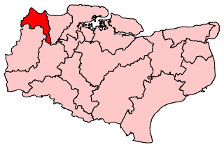
Dartford is the principal town in the Borough of Dartford, Kent, England. It is located 18 mi (29 km) south-east of Central London and is situated adjacent to the London Borough of Bexley to its west. To its north, across the Thames estuary, is Thurrock in Essex, which can be reached via the Dartford Crossing. To its east lies the Borough of Gravesham and to the south the district of Sevenoaks. It had a population of 51,240.

<span class="mw-page-title-main">Kent County Council</span> British administrative authority

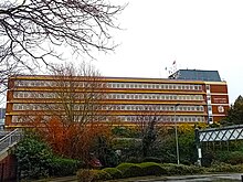
Kent County Council is a county council that governs the non-metropolitan county of Kent in England. The non-metropolitan county is smaller than the ceremonial county, which additionally includes the unitary authority of Medway. Kent County Council is the upper tier of elected local government, below which are 12 district councils, and around 300 town and parish councils. The county council has 81 elected councillors. It is one of the largest local authorities in England in terms of population served and the largest local authority of its type. The council is based at County Hall in Maidstone. It has been under Conservative majority control since 1997.

<span class="mw-page-title-main">North Kent Line</span> British railway line

The North Kent Line is a railway line which branches off the South East Main Line at St Johns junction west of Lewisham station in Greater London and runs to Rochester Bridge Junction near Strood, Medway where it links to the Chatham Main Line.

<span class="mw-page-title-main">Dartford (UK Parliament constituency)</span> UK Parliament constituency since 1885

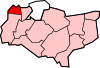
Dartford is a constituency in Kent represented in the House of Commons of the UK Parliament since 2010 by Gareth Johnson of the Conservative Party. It is the constituency that, in the entire UK, has longest been a bellwether: the party of the winning candidate has gone on to form the government at every UK general election since 1964. Candidates for the largest two parties nationally have polled first and second since 1923 in Dartford.

<span class="mw-page-title-main">Arriva Southern Counties</span> Bus operator in East Sussex, Kent and Essex

Arriva Southern Counties Limited, trading as Arriva Southern Counties, is a bus operator in Kent, Essex, Hemel Hempstead, and Watford in England. It is a subsidiary of Arriva UK Bus.

<span class="mw-page-title-main">Ebbsfleet International railway station</span> Railway station in Kent, England

Ebbsfleet International railway station is in Ebbsfleet Valley, Kent, 10 miles east of London, England, near Dartford and the Bluewater shopping centre to the west and Gravesend to the east. The station, part of the Thames Gateway urban regeneration project, is on the High Speed 1 (HS1) rail line, 400 metres south-west of Northfleet railway station, off the A2 trunk road, 5 mi (8.0 km) from its junction with the M25 motorway. It served as a primary park-and-rail service for the London 2012 Olympics.

Dartford Borough Council is the local authority for the Borough of Dartford in Kent, England. The council is elected every four years.

Swanscombe and Greenhithe is a civil parish in the Borough of Dartford in Kent, England. Swanscombe and Greenhithe is a recent renaming of the ancient parish of Swanscombe, covering Swanscombe and Greenhithe. The parish included much of the Ebbsfleet Valley new town development until 2019. The local council is Swanscombe and Greenhithe Town Council.

<span class="mw-page-title-main">Arriva Kent Thameside</span>

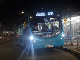
Arriva Kent Thameside Limited, trading as Arriva Kent Thameside, is a bus operator based in north-west Kent, England. It is a subsidiary of Arriva UK Bus. The company operates services in Northfleet, Gravesend & Dartford as part of the Arriva Southern Counties division from their Northfleet depot.

<span class="mw-page-title-main">A226 road</span> Road in southeast England

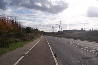
The A226 road travels in a west–east direction in southeast London and north Kent, from Crayford in the London Borough of Bexley, through Dartford, Gravesend to Strood. It is about 15.7 miles in length.

<span class="mw-page-title-main">Fastrack (bus)</span> Bus Rapid Transit network in Kent, England

Fastrack is a bus rapid transit scheme in the Thames Gateway area of Kent. It consists of three routes, operated by Arriva Southern Counties on behalf of Kent County Council with Prologis and Amazon respectively. Measures used to allow buses to avoid traffic include signal priority, reserved lanes, and dedicated busways.

Ebbsfleet Valley is a new town and redevelopment area in Kent, South East England, and part of the Thames Gateway, southwest of Gravesend. Development is coordinated by the Ebbsfleet Development Corporation.

New Barn is a village in Kent, England. It is a compact residential area surrounded by open fields which lies four miles southwest of Gravesend. It is in the local government district of Dartford. The villages of New Barn and Longfield are within and give their names to the civil parish of Longfield and New Barn. New Barn is larger in population than Longfield, although has little in the way of services, being a recent development and purely residential in nature

References

  1. 1 2 UK Census (2021). "2021 Census Area Profile – Dartford Horse Local Authority (E07000107)". Nomis. Office for National Statistics . Retrieved 5 January 2024.
  2. "Dartford Improvement Act 1814". legislation.gov.uk. The National Archives. Retrieved 14 May 2024.
  3. Lawes, Edward (1851). The Act for Promoting the Public Health, with notes. London: Shaw and Sons. p. 262. Retrieved 14 May 2024.
  4. "Dartford Urban District / Municipal Borough". A Vision of Britain through Time. GB Historical GIS / University of Portsmouth. Retrieved 14 May 2024.
  5. "The English Non-metropolitan Districts (Definition) Order 1972", legislation.gov.uk , The National Archives, SI 1972/2039, retrieved 12 May 2024
  6. "The English Non-metropolitan Districts (Names) Order 1973", legislation.gov.uk , The National Archives, SI 1973/551, retrieved 3 March 2023
  7. Alterations of area and status of local authorities (PDF). London: Department of the Environment. 1977. p. 1. Archived from the original (PDF) on 3 June 2011. Retrieved 14 May 2024.
  8. "The Kent (District Boundaries) Order 1987", legislation.gov.uk , The National Archives, SI 1987/305, retrieved 14 May 2024
  9. "Local Government Act 1972", legislation.gov.uk , The National Archives, 1972 c. 70, retrieved 31 May 2023
  10. 1 2 3 "Election Maps". Ordnance Survey. Retrieved 14 May 2024.
  11. "Compositions calculator". The Elections Centre. Retrieved 9 September 2022.
  12. "English local elections 2007: Dartford". BBC News. 4 May 2007. Retrieved 25 July 2022.
  13. "Council minutes". Dartford Borough Council. Retrieved 25 July 2022.
  14. "New chairman". Kent Today. Maidstone. 17 July 1992. p. 1. Retrieved 14 May 2024.
  15. Delaney, Sean (4 February 2022). "Tributes to former Dartford council leader Ivor Jones who served for 56 years in Dartford and Stone". Kent Online. Retrieved 14 May 2024.
  16. Prout, Geoff (18 September 2014). "John Muckle obituary". The Guardian. Retrieved 25 July 2022.
  17. "Council leader resigns from post". BBC News. 20 February 2006. Retrieved 25 July 2022.
  18. "Local elections 2023: live council results for England". The Guardian.
  19. "The Dartford (Electoral Changes) Order 2018", legislation.gov.uk , The National Archives, SI 2018/1175, retrieved 14 May 2024
  20. "Contact us". Dartford Borough Council. Retrieved 14 May 2024.
  21. "Office development is completed". Kent Evening Post. Maidstone. 10 September 1975. p. 25. Retrieved 14 May 2024.
  22. "No. 50177". The London Gazette . 28 June 1985. p. 8914.
  23. Central Park: A Hundred Years. Dartford Borough Council. 2005. p. 4. Retrieved 14 May 2024.
  24. Historic England. "45 High Street (Grade II*) (1336369)". National Heritage List for England . Retrieved 14 May 2024.
  25. Dartford Town Centre Conservation Area Appraisal and Management Plan (PDF). Dartford Borough Council. October 2006. p. A-6. Retrieved 14 May 2024.
  26. Approve, IT. "Dartford Youth Council". www.dartford.gov.uk. Retrieved 3 June 2017.
  27. 1 2 "Our Work". Dartford Youth Council. 11 February 2017. Retrieved 3 June 2017.
  28. "2011 Census". Archived from the original on 11 February 2003. Retrieved 21 June 2013.
  29. Britcher, Chris (23 December 2023). "London Resort: The truth behind the £2.5bn scheme to rival Disney as we talk to LRCH chair Steve Norris and ask can the Swanscombe Peninsula finally relax?". Kent Online. Retrieved 14 May 2024.
  30. "Parish council contact details". Dartford Borough Council. Retrieved 14 May 2024.
  31. "Kent: Diagram showing administrative boundaries, 1972". National Library of Scotland. Ordnance Survey. Retrieved 14 May 2024.
  32. "The Dartford Borough Council (Reorganisation of Community Governance) Order 2018" (PDF). Local Government Boundary Commission for England. The National Archives. Retrieved 14 May 2024.