Borough of Swale

Last updated

Borough of Swale
The High Street in Sittingbourne - geograph.org.uk - 3180348.jpg
Sittingbourne town centre
Swale UK locator map.svg
Swale shown within Kent
Coordinates: 51°20′24.73″N0°43′51.32″E / 51.3402028°N 0.7309222°E / 51.3402028; 0.7309222
Sovereign state United Kingdom
Constituent country England
Region South East England
Non-metropolitan county Kent
Status Non-metropolitan district
Admin HQ Sittingbourne
Incorporated1 April 1974
Government
  TypeNon-metropolitan district council
  BodySwale Borough Council
   MPs Helen Whately (C)
Gordon Henderson (C)
Area
  Total144.2 sq mi (373.4 km2)
  Rank93rd (of 296)
Population
 (2022)
  Total154,619
  Rank139th (of 296)
  Density1,100/sq mi (410/km2)
Ethnicity (2021)
[1]
   Ethnic groups
List
Religion (2021)
[1]
   Religion
List
Time zone UTC0 (GMT)
  Summer (DST) UTC+1 (BST)
ONS code 29UM (ONS)
E07000113 (GSS)
OS grid reference TQ9018863720

Swale is a local government district with borough status in Kent, England. The council is based in Sittingbourne, the borough's largest town. The borough also contains the towns of Faversham, Queenborough and Sheerness, along with numerous villages and surrounding rural areas. It includes the Isle of Sheppey and is named after The Swale, the narrow channel which separates Sheppey from the mainland part of the borough. Some southern parts of the borough lie within the Kent Downs, a designated Area of Outstanding Natural Beauty.

Contents

The borough borders the Medway unitary authority area to the west, the Borough of Maidstone to the south-west, the Borough of Ashford to the south-east, and the City of Canterbury to the east.

History

The district was created on 1 April 1974 under the Local Government Act 1972 covering the area of four former districts, which were all abolished at the same time: [2]

The new district was named Swale, after the waterway which divides the mainland part of the district from the Isle of Sheppey. [3] The district was awarded borough status on 20 January 1978, allowing the chair of the council to take the title of mayor. [4]

Governance

Swale Borough Council
Swale Borough Council.svg
Type
Type
History
Founded1 April 1974
Leadership
Sarah Stephen,
Swale Independents
since 17 May 2023 [5]
Tim Gibson,
Labour
since 17 May 2023
Larissa Reed
since January 2021 [6]
Structure
Seats47 councillors
Swale district council after 2023.svg
Political groups
Administration (31)
  Labour (16)
  Swale Independents (11)
  Green (3)
  Independent (1)
Other parties (16)
  Conservative (11)
  Liberal Democrats (5)
Length of term
4 years
Elections
First-past-the-post
Last election
4 May 2023
Next election
6 May 2027
Motto
Known By Their Fruits
Meeting place
Swale House, East Street, Sittingbourne, Kent - geograph.org.uk - 927659.jpg
Swale House, East Street, Sittingbourne, ME10 3HT
Website
www.swale.gov.uk

Swale Borough Council provides district-level services. County-level services are provided by Kent County Council. Most of the borough is also covered by civil parishes, which form a third tier of local government. [7] [8]

Political control

The council has been under no overall control since 2019. Following the 2023 election a coalition of Labour, local party the Swale Independents, the Greens and an independent councillor have formed the council's administration. [9]

The first election to the council was held in 1973, initially operating as a shadow authority alongside the outgoing authorities before coming into its powers on 1 April 1974. Political control of the council since 1974 has been as follows: [10] [11] [12]

Party in controlYears
No overall control 1974–1976
Conservative 1976–1986
No overall control 1986–2002
Conservative 2002–2019
No overall control 2019–present

Leadership

The role of Mayor of Swale is largely ceremonial. Political leadership is instead provided by the leader of the council. The leaders since 2002 have been: [13]

CouncillorPartyFromTo
Andrew Bowles Conservative 20025 May 2019
Roger Truelove Labour 22 May 201927 Apr 2022
Mike Baldock Swale Ind. 27 Apr 202219 May 2023
Tim Gibson Labour 19 May 2023

Composition

Following the 2023 election, a subsequent by-election in September 2023, and a defection from the Swale Independents Alliance to the Labour Party, the composition of the council was: [14] [15] [16]

PartyCouncillors
Labour 16
Swale Ind. 10
Conservative 11
Liberal Democrats 5
Green 3
Independent 1
Total47

The independent councillor and the Swale Independents sit together as the "Swale Independents Alliance". [17] The next elections are due in 2027.

Elections

Since the last boundary changes in 2015 the council has comprised 47 councillors representing 24 wards, with each ward electing one, two or three councillors. Elections are held every four years. [18]

Premises

The council is based at Swale House on East Street in Sittingbourne. [19]

Economy

Swale is a mainly rural borough, containing a high proportion of the UK's apple, pear, cherry and plum orchards (the North Kent Fruit Belt [20] ), as well as many of its remaining hop gardens. Faversham has the Shepherd Neame brewery. Founded in 1698 it is claimed to be oldest brewery in the UK.

Sheerness is a busy port and previously produced steel. Sittingbourne has a variety of smaller industrial sites.

Transport

The Roman Watling Street passed through the area, as witness the straightness of the A2 main road, now by-passed by the M2 motorway.

There are two railway lines in Swale: the Chatham Main Line and the Sheerness Branch Line, which meet at Sittingbourne.

Two adjoining bridges across The Swale link the Isle of Sheppey to the mainland: Kingsferry Bridge and the Sheppey Crossing.

Media

In terms of television, Swale is served by BBC South East and ITV Meridian (East) broadcasting from the Bluebell Hill transmitter. [21]

Local radio stations are:

Local newspapers are Sittingbourne News Extra , [23] yourswale, and Sheerness Times Guardian that serves the Isle of Sheppey.

Parishes

Most of the borough is covered by civil parishes. The parish councils for Faversham, Queenborough and Sheerness take the style "town council". [24] The former Sittingbourne and Milton Urban District is an unparished area, as is the Halfway Houses area on Sheppey, being the only part of the pre-1974 borough of Queenborough-in-Sheppey not to have been subsequently added to a parish. [8]

Mayors

For the council's first four years it had a chairman rather than a mayor. The chairmen were:

From the grant of borough status in January 1978 onwards the chairman of the council has taken the title of mayor. The mayors have been:

Honorary Freemen of the Borough

Related Research Articles

<span class="mw-page-title-main">Isle of Sheppey</span> Island off the coast of Kent, England

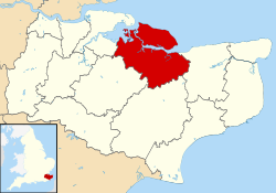
The Isle of Sheppey is an island off the northern coast of Kent, England, neighbouring the Thames Estuary, centred 42 miles (68 km) from central London. It has an area of 36 square miles (93 km2). The island forms part of the local government district of Swale. Sheppey is derived from Old English Sceapig, meaning "Sheep Island".

<span class="mw-page-title-main">Queenborough</span> Town in Kent, England

Queenborough is a town on the Isle of Sheppey in the Swale borough of Kent in South East England.

<span class="mw-page-title-main">Sheerness</span> Town in Kent, England

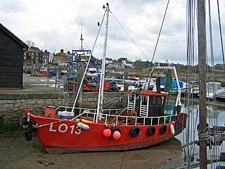
Sheerness is a port town and civil parish beside the mouth of the River Medway on the north-west corner of the Isle of Sheppey in north Kent, England. With a population of 11,938, it is the second largest town on the island after the nearby town of Minster which has a population of 21,319.

<span class="mw-page-title-main">Minster, Swale</span> Town on the Isle of Sheppey, Kent, England

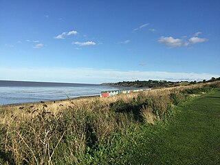
Minster is a town on the north coast of the Isle of Sheppey in Kent, south-east England. It is in the Swale administrative district, and within that, in the parish of Minster-on-Sea. According to the 2021 Census, the population of Minster was 17,389.

<span class="mw-page-title-main">Sittingbourne and Sheppey (UK Parliament constituency)</span>

Sittingbourne and Sheppey is a constituency in Kent represented in the House of Commons of the UK Parliament since 2010 by Gordon Henderson, a Conservative.

The constituency of Queenborough was a rotten borough situated on the Isle of Sheppey in Kent.

Queenborough-in-Sheppey was a municipal borough in Kent, England from 1968 to 1974. It was created by a merger of the Municipal Borough of Queenborough with Sheerness Urban District and Sheppey Rural District, and occupied the entire Isle of Sheppey. It incorporated the following parishes:

<span class="mw-page-title-main">A249 road</span> Road in Kent, England

The A249 is a road in Kent, England, running from Maidstone to Sheerness on the Isle of Sheppey. It mainly functions as a link between the M2 and M20 motorways, and for goods vehicle traffic to the port at Sheerness.

<span class="mw-page-title-main">Faversham (UK Parliament constituency)</span>

Faversham was a parliamentary constituency centred on the town of Faversham in Kent which returned one Member of Parliament (MP) to the House of Commons of the Parliament of the United Kingdom.

<span class="mw-page-title-main">Elmley</span> Human settlement in England

Elmley is the local name for the Isle of Elmley, in the civil parish of Minster-on-Sea, part of the Isle of Sheppey in the Swale district, in the county of Kent, England. It was also the name of a very late 19th century industrial village on the isle. Edward Hasted describes, in 1798, the isle as two-eighths of the Isle of Sheppey estimated as 11 miles by 8 miles. Its present national nature reserve covers more than the easily traceable area of the former isle by extending to the east, over Windmill Creek, one of two Sheppey inlets, former internal tidal channels.

<span class="mw-page-title-main">Leaveland</span> Human settlement in England

Leaveland is a hamlet and civil parish located in the Swale borough of Kent, South East England. In terms of topography, it is described as a "village surrounded by inhabited countryside", and is situated mostly on high ground. It is located 5 miles South of Faversham, West of Badlesmere, and on or close to the A251.The closest railway station to the area is Selling, which is just over three miles away, although Faversham station is more accessible and offers better services. The closest estuary is The Swale which separates the Isle of Sheppey from mainland Kent, and flows to the north of Faversham Creek.. Leaveland itself covers an area of 1.5 km2 and lies entirely within the Kent Downs Area of Outstanding Natural Beauty.

<span class="mw-page-title-main">Halfway Houses, Kent</span> Human settlement in England

Halfway Houses is a village on the Isle of Sheppey in the Swale borough of Kent in England. It derives its name from the pub in the village centre, with the same name, which was so named because it is halfway between Minster and Sheerness, before the coastal road was built along the north coast connecting Minster and Sheerness. It is bordered to the west by the town of Queenborough and the village of Minster-on-Sea, and to the east by the town of Minster. It is one mile south of the town of Sheerness. It is in the Queenborough and Halfway ward of Swale Borough Council.

The National Cycle Route 174 is part of the National Cycle Network in the United Kingdom. Part of it is known as The Sheerness Way.

<span class="mw-page-title-main">2006 Swale Borough Council election</span> 2006 UK local government election

The 2006 Swale Borough Council election took place on 4 May 2006 to elect members of Swale Borough Council in Kent, England. One third of the council was up for election and the Conservative Party stayed in overall control of the council.

<span class="mw-page-title-main">2007 Swale Borough Council election</span> 2007 UK local government election

The 2007 Swale Borough Council election took place on 3 May 2007 to elect members of Swale Borough Council in Kent, England. One third of the council was up for election and the Conservative Party stayed in overall control of the council.

<span class="mw-page-title-main">2008 Swale Borough Council election</span> 2008 UK local government election

The 2008 Swale Borough Council election took place on 1 May 2008 to elect members of Swale Borough Council in Kent, England. One third of the council was up for election and the Conservative Party stayed in overall control of the council.

<span class="mw-page-title-main">2017 Kent County Council election</span> 2017 UK local government election

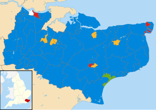
The 2017 Kent County Council election was held on 4 May 2017 as part of the 2017 local elections in the United Kingdom. All 81 councillors were elected from 72 electoral divisions, each of which returned either one or two county councillors by first-past-the-post voting for a four-year term of office. The Conservative Party retained control. UKIP, previously the second-largest party on the council, lost all their seats.

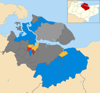
Elections were held to Swale Borough Council in England as part of the United Kingdom local elections on 2 May 2019.

<span class="mw-page-title-main">2023 Swale Borough Council election</span>

The 2023 Swale Borough Council election took place on 4 May 2023 to elect members of Swale Borough Council in Kent, England. This was on the same day as other local elections across England.

References

  1. 1 2 UK Census (2021). "2021 Census Area Profile – Swale Local Authority (E07000113)". Nomis. Office for National Statistics . Retrieved 5 January 2024.
  2. "The English Non-metropolitan Districts (Definition) Order 1972", legislation.gov.uk , The National Archives, SI 1972/2039, retrieved 27 September 2023
  3. "The English Non-metropolitan Districts (Names) Order 1973", legislation.gov.uk , The National Archives, SI 1973/551, retrieved 31 May 2023
  4. Alteration of Status of Local Authorities June 1977 – January 1978 (PDF). London: Department of the Environment. 1978. p. 2. Archived from the original (PDF) on 3 June 2011. Retrieved 29 September 2023.
  5. "Council minutes, 17 May 2023". Swale Borough Council. Retrieved 29 September 2023.
  6. George, Martin (8 October 2020). "New Swale chief executive named". Local Government Chronicle. Retrieved 29 September 2023.
  7. "Local Government Act 1972", legislation.gov.uk , The National Archives, 1972 c. 70, retrieved 31 May 2023
  8. 1 2 "Election Maps". Ordnance Survey. Retrieved 29 September 2023.
  9. Boothroyd, David (19 May 2023). "As a Green councillor walked out one midsummer morning". Local Councils. Retrieved 28 September 2023.
  10. "Compositions calculator". The Elections Centre. 4 March 2016. Retrieved 29 September 2023.
  11. "England council elections". BBC News Online. 10 May 2011. Retrieved 25 March 2015.
  12. "Swale Borough Council". BBC News. Retrieved 3 February 2020.
  13. "Council minutes". Swale Borough Council. Retrieved 26 July 2022.
  14. "Local elections 2023: live council results for England". The Guardian.
  15. Harbert, Joe (14 September 2023). "By-election for Minster Cliffs ward on Swale Borough Council following Ken Ingleton's death". Kent Online. Retrieved 29 September 2023.
  16. "Minster Cliffs by-election results". Swale Borough Council. Retrieved 29 September 2023.
  17. "Your Councillors by Party". Swale Borough Council. Retrieved 29 September 2023.
  18. "The Swale (Electoral Changes) Order 2012", legislation.gov.uk , The National Archives, SI 2012/2985, retrieved 29 September 2023
  19. "Our offices". Swale Borough Council. Retrieved 29 September 2023.
  20. Orchards http://www.englandinparticular.info/orchards/o-kent.html
  21. "Full Freeview on the Bluebell Hill (Medway, England) transmitter". UK Free TV. 1 May 2004. Retrieved 15 April 2024.
  22. "106.9 SFM – 100% Local Radio For Sittingbourne" . Retrieved 14 April 2024.
  23. "Sittingbourne News Extra". British Papers. 4 February 2014. Retrieved 15 April 2024.
  24. "Parish council contact details". Swale Borough Council. Retrieved 29 September 2023.
  25. "Photograph of Bob Geldof Receiving the Freedom of the Borough of Swale". Shutterstock. Retrieved 31 October 2021.
  26. Dunt, Paul (13 October 2021). "Former Sheerness RNLI Coxswain honoured with Freedom of the Borough". The Royal National Lifeboat Institution. Retrieved 31 October 2021.
  27. "Photograph of Robin Swale Receiving the Freedom of the Borough of Swale". Twitter. Retrieved 31 October 2021.