Chichester District

Last updated

Chichester District
Cathedral spire and Guildhall, Chichester - geograph.org.uk - 4941954.jpg
Chichester UK locator map.svg
Chichester shown within West Sussex
Sovereign state United Kingdom
Constituent country England
Region South East England
Non-metropolitan county West Sussex
Status Non-metropolitan district
Admin HQ Chichester
Incorporated1 April 1974
Government
  TypeNon-metropolitan district council
  BodyChichester District Council
   MPs Andrew Griffith
Jeremy Quin
Gillian Keegan
Area
  Total303.60 sq mi (786.32 km2)
  Rank42nd (of 296)
Population
 (2021)
  Total124,531
  Rank189th (of 296)
  Density410/sq mi (160/km2)
Ethnicity (2021)
[1]
   Ethnic groups
List
Religion (2021)
[1]
   Religion
List
Time zone UTC0 (GMT)
  Summer (DST) UTC+1 (BST)

Chichester is a local government district in West Sussex, England. It is named after the city of Chichester, which is its largest settlement and where the council is based. The district includes the towns of Midhurst, Petworth and Selsey and surrounding rural areas, including many villages. The district includes part of the South Downs National Park, and Chichester Harbour is a designated Area of Outstanding Natural Beauty. At the 2021 census the district had a population of 124,531.

Contents

The district is on the coast, facing the English Channel. The neighbouring districts are Arun, Horsham, Waverley, East Hampshire and Havant.

History

Chichester itself had been an ancient borough, which additionally held city status from 1075 when the Diocese of Chichester moved its seat from Selsey to Chichester. [2] [3]

The modern district was formed on 1 April 1974 under the Local Government Act 1972 as one of seven districts within West Sussex. The new district covered the whole area of three former districts and parts of a fourth, which were all abolished at the same time: [4]

The new district was named Chichester, after its largest settlement. The medieval territory of the Rape of Chichester had also covered much of the area of the new district. [5] A successor parish was established covering the former borough of Chichester, and Chichester's city status passed to the new parish rather than the wider district. As such, Chichester City Council is a parish council, whilst Chichester District Council has greater powers and covers the much larger area of Chichester District. [6]

Governance

Chichester District Council
Logo of Chichester District Council.png
Type
Type
History
Founded 1 April 1974
Leadership
Clare Apel,
Liberal Democrat
since 17 May 2023 [7]
Adrian Moss,
Liberal Democrat
since 17 May 2023
Diane Shepherd
since 2012 [8]
Structure
Seats36 councillors
Chichester District Council composition.svg
Political groups
Administration (25)
  Liberal Democrats (25)
Other parties (11)
  Conservative (5)
  Local Alliance (4)
  Green (2)
Length of term
4 years
Elections
First-past-the-post
Last election
4 May 2023
Next election
6 May 2027
Meeting place
East Pallant House.jpg
East Pallant House, 1 East Pallant, Chichester, PO19 1TY
Website
www.chichester.gov.uk

Chichester District Council provides district-level services. County-level services are provided by West Sussex County Council. [9] The whole district is also covered by civil parishes, which form a third tier of local government. [10]

In the parts of the district within the South Downs National Park, town planning is the responsibility of the South Downs National Park Authority. The district council appoints one of its councillors to serve on the 27-person National Park Authority. [11]

Political control

The council has been under Liberal Democrat majority control since the 2023 election. [12]

The first elections to the council were held in 1973, initially operating as a shadow authority alongside the outgoing authorities until the new arrangements came into effect on 1 April 1974. Political control of the council since 1974 has been as follows: [13] [14] [15]

Party in controlYears
No overall control 1974–1976
Conservative 1976–1995
No overall control 1995–1999
Conservative 1999–2004
No overall control 2004–2006
Conservative 2006–2019
No overall control 2019–2019
Conservative 2019–2020
No overall control 2020–2023
Liberal Democrats 2023–present

Leadership

The leaders of the council since 1999 have been: [16]

CouncillorPartyFromTo
Jane Chevis Conservative 19992002
Janet Duncton Conservative 20022005
Andrew Smith Liberal Democrats 20052006
Myles Cullen Conservative 20062011
Heather Caird Conservative 201110 May 2015
Tony Dignum Conservative 19 May 201521 May 2019
Eileen Lintill Conservative 21 May 20197 May 2023
Adrian Moss Liberal Democrats 17 May 2023

Composition

Following the 2023 election, the composition of the council was: [17]

PartyCouncillors
Liberal Democrats 25
Conservative 5
Local Alliance 4
Green 2
Total36

The Local Alliance and Greens sit together as a group, which forms the council's largest opposition group. [18] The next election is due in 2027.

Elections

Since the last boundary changes in 2019 the council has comprised 36 councillors representing 21 wards, with each ward electing one, two or three councillors. Elections are held every four years. [19]

Councillors and wards

List of Chichester district councillors by ward: [20]

WardCouncillorElectedNotes
Chichester West Clare Apel1999Member of Chichester City Council
The Witterings Iain Ballantyne2023
Southbourne Tracie Bangert2019Cabinet Member for Communities and Wellbeing
Harbour Villages Richard Bates2023
North Mundham and Tangmere David Betts2023Cabinet Member for Housing and Revenues and Benefits
Selsey South Steve Boulcott2023
Chichester East Bill Brisbane2021Cabinet Member for Planning
Elected following a by-election held in June 2021 [21]
Westbourne Roy Briscoe2019
Lavant Joseph Brookes-Harmer2023
Chichester North Jonathan Brown2023Deputy Leader of the Council and Cabinet Member for Environmental Strategy
Previously represented Southbourne (2015–2023)
Midhurst Jess Brown-Fuller2023Cabinet Member for Culture and Events
Fernhurst Brett Elise Burkhart2023
Midhurst Hannah Burton2023
Chichester East Rhys Chant2023Member of Chichester City Council
The Witterings Mark Chilton2023Cabinet Member for Finance, Corporate Services and Chichester Contract Services
Chichester North Maureen Corfield2023Member of Chichester City Council
Fittleworth John Cross2023
Petworth Harsha Desai2023Cabinet Member for Growth and Place
Loxwood Gareth Evans2019
The Witterings Elizabeth Hamilton2019Previously represented Easebourne (2007–2015) and West Wittering (2015–2019)
North Mundham and Tangmere Charlie Hastain2023
Southbourne Oona Hickson2023
Easebourne Francis Hobbs2015
Sidlesham with
Selsey North
Donna Johnson2019Member of West Sussex County Council
Harbour Villages Stephen Johnson2023
Selsey South Timothy Johnson2019
Harbour Villages Adrian Moss2019Leader of the Council
Previously represented Fishbourne (2003–2011; 2018–2019)
Fernhurst Eleanora Newbery2023
Harting Tim O'Kelly2023
Goodwood Henry Potter2019Previously represented Boxgrove (2007–2019)
Chichester West Sarah Quail2023Member of Chichester City Council
Chichester South Sarah Sharp2019Member of West Sussex County Council
Loxwood Charles Todhunter2023
Chichester Central James Vivian2023Member of Chichester City Council
Sidlesham with
Selsey North
Val Weller2023
Chichester South Tim Young2023

Premises

The council is based at East Pallant House, on East Pallant in the centre of Chichester. The oldest part of the building was originally a large house, which had subsequently served as the headquarters of the old Chichester Rural District Council prior to the 1974 reorganisation. Large modern extensions have since been added to the building. [22]

Geography

Chichester District occupies the western part of West Sussex, bordering on Hampshire to the west and Surrey to the north. The districts of Arun and Horsham abut to the east; the English Channel to the south. The district is divided by the South Downs escarpment, with the northern part being in the Weald, composed of a mixture of sandstone ridges and low-lying clays known as the Western Weald. To the south the dip slope of the downs falls gently to a flat coastal plain and the sea. The Western Weald is drained by the River Arun and its tributaries including the rivers Lox, Kird and especially the River Rother and its tributaries the River Lod and the Haslingbourne Stream. On the northern boundary Blackdown is the highest point in Sussex, while further east around Loxwood the land is low and quite flat. The south of the district has many permeable chalk and gravel areas and is drained by two winterbournes, the River Lavant and River Ems, which are usually dry in the summer. The large inlet known as Chichester Harbour and the headland of Selsey Bill are conspicuous features of the coast.

The district, apart from the few main roads, is generally rural in character, as can be seen by the number of villages within it. Apart from the coastal strip there are few main roads, and the erstwhile railways which once served Midhurst have long been closed.

Civil parishes

Beach at Selsey, the district's second largest settlement Beach at Selsey, West Sussex, England.jpg
Beach at Selsey, the district's second largest settlement
South Street, Midhurst Midhurst from the South.JPG
South Street, Midhurst

There are 67 civil parishes in Chichester District. [23] [24] The parish of Chichester holds city status, allowing the parish council to call itself a city council. [6] The parish councils for Midhurst, Petworth and Selsey have each declared their parishes to be towns, allowing them to take the style "town council". Some of the smaller parishes have a parish meeting rather than a parish council. [25]

Landmarks

Apart from the geographical landmarks Chichester District contains architectural and cultural places including Chichester Cathedral, Chichester Festival Theatre, The Novium and Pallant House Gallery in the city. Stately homes open to the public include Petworth House and Uppark, both National Trust properties, Goodwood House and Stansted Park. West Dean College is open at certain times of the year. There is horse racing at Goodwood Racecourse, the Goodwood Festival of Speed at Goodwood House, and the Goodwood Revival at Goodwood Motor Racing Circuit. Cowdray House is a ruined Tudor mansion near Midhurst. Fishbourne Roman Palace lies west of Chichester city centre. To the north of the city are Weald and Downland Open Air Museum and Halnaker Windmill. There are gardens open to the public at Woolbeding and Pound Commons and West Dean College.

Economy

West Sussex County Council and Chichester District Council are major employers in Chichester, along with Rolls-Royce Motor Cars assembly plant at nearby Westhampnett. Boatbuilding is an important industry along the coast. Many people from the northern parts of the district commute to work in London, using the A3 road or the railways from Portsmouth to London Waterloo station and Littlehampton to London Victoria station.[ citation needed ] Fertile soils on the coastal plain are used for arable farming and intensive vegetable production, the latter employing many migrant workers from Eastern Europe. High sunlight levels and a mild climate also make the coastal region suitable for glasshouse growing. A fertile strip of land on the north side of the River Rother is also used for vegetable growing, but most of the area north of the Downs is of low agricultural value and there are large areas of forest and pasture, interspersed with arable cropping.

Football clubs

Related Research Articles

<span class="mw-page-title-main">West Sussex</span> County of England

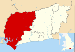
West Sussex is a ceremonial county in South East England. It is bordered by Surrey to the north, East Sussex to the east, the English Channel to the south, and Hampshire to the west. The largest settlement is Crawley, and the county town is the city of Chichester.

<span class="mw-page-title-main">Mid Sussex District</span> Non-metropolitan district in England

Mid Sussex is a local government district in West Sussex, England. The largest town is Haywards Heath, where the council is based. The district also contains the towns of Burgess Hill and East Grinstead plus surrounding rural areas, including many villages. The district includes part of the South Downs National Park and part of the designated Area of Outstanding Natural Beauty of High Weald, including sections of Ashdown Forest. The district contains most headwaters of the River Ouse. Its largest body of water is Ardingly reservoir which is used by watersports clubs. At the 2021 census the district had a population of 152,949.

<span class="mw-page-title-main">Arun District</span> Local government district in West Sussex, England

Arun is a local government district in West Sussex, England. Its council is based in Littlehampton. The district's other towns are Arundel and Bognor Regis. The district is named after the River Arun, which runs through the centre of the district. Parts of the district fall within the South Downs National Park.

<span class="mw-page-title-main">Petworth</span> Human settlement in England

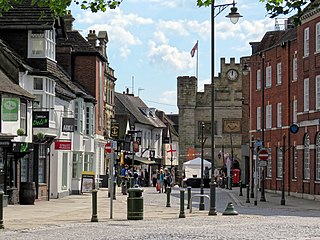
Petworth is a town and civil parish in the Chichester District of West Sussex, England. It is located at the junction of the A272 east–west road from Heathfield to Winchester and the A283 Milford to Shoreham-by-Sea road.

<span class="mw-page-title-main">Wealden District</span> District in East Sussex, England

Wealden is a local government district in East Sussex, England. Its council is based in Hailsham, the district's largest town. The district also includes the towns of Crowborough, Polegate and Uckfield, along with numerous villages and surrounding rural areas. The district's name comes from the Weald, the landscape and ancient woodland which occupies much of the centre and north of the area.

<span class="mw-page-title-main">Horsham District</span> Local government district in West Sussex, England

Horsham is a local government district in West Sussex, England. It is named after the town of Horsham, which is its largest settlement and where the council is based. The district also includes the surrounding rural area and contains many villages, the largest of which are Southwater and Billingshurst. The district includes part of the South Downs National Park and part of the designated Area of Outstanding Natural Beauty of High Weald. At the 2021 census the district had a population of 147,487.

<span class="mw-page-title-main">Midhurst</span> Market town in West Sussex, England

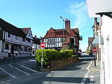
Midhurst is a market town, parish and civil parish in West Sussex, England. It lies on the River Rother 20 miles (32 km) inland from the English Channel, and 12 miles (19 km) north of the county town of Chichester.

<span class="mw-page-title-main">South Downs National Park</span> National park in South East England

The South Downs National Park is England's newest national park, designated on 31 March 2010. The park, covering an area of 1,627 square kilometres (628 sq mi) in southern England, stretches for 140 kilometres (87 mi) from Winchester in the west to Eastbourne in the east through the counties of Hampshire, West Sussex and East Sussex. The national park covers the chalk hills of the South Downs and a substantial part of a separate physiographic region, the western Weald, with its heavily wooded sandstone and clay hills and vales. The South Downs Way spans the entire length of the park and is the only National Trail that lies wholly within a national park.

<span class="mw-page-title-main">Arundel and South Downs (UK Parliament constituency)</span> Parliamentary constituency in the United Kingdom, 1997 onwards

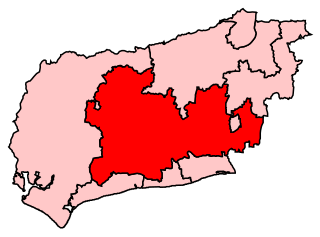
Arundel and South Downs is a constituency in West Sussex created in 1997 and represented in the House of Commons of the UK Parliament since 2019 by Andrew Griffith of the Conservative Party.

<span class="mw-page-title-main">Chichester (UK Parliament constituency)</span> Parliamentary constituency in the United Kingdom

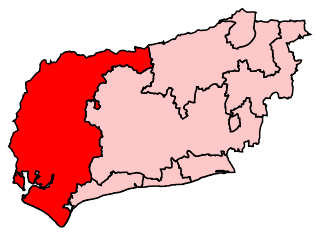
Chichester is a constituency in West Sussex, represented in the House of Commons of the UK Parliament since 2017 by Gillian Keegan, a Conservative.

<span class="mw-page-title-main">Heyshott</span> Human settlement in England

Heyshott is a village, Anglican parish and civil parish in the Chichester district of West Sussex, England. It is approximately three miles south of Midhurst and lies within the South Downs National Park. Like many villages it has lost its shop but still has one pub, The Unicorn Inn. The hamlet of Hoyle is to the northeast of the village.

<span class="mw-page-title-main">Lodsworth</span> Human settlement in England

Lodsworth is a small village, ecclesiastical parish and civil parish in the Chichester district of West Sussex, England. It is situated between Midhurst and Petworth, half a mile north of the A272 road. It lies within the South Downs National Park, just to the north of the valley of the River Rother; a tributary stream the River Lod runs close to the east end of the village.

<span class="mw-page-title-main">Lurgashall</span> Human settlement in England

Lurgashall is a village and civil parish in the Chichester district of West Sussex, England, 6.5 km north west of Petworth, just inside the South Downs National Park. The population at the 2011 Census was 609.

<span class="mw-page-title-main">A286 road</span> Road in the south east of England

The A286 is an A class road in the south of England, from its northernmost point in Milford, Surrey, to Birdham, West Sussex. It passes through the market towns of Haslemere and Midhurst, and the cathedral city of Chichester. The road is mostly single carriageway, with a small dual carriageway section as part of the Chichester ring road.

<span class="mw-page-title-main">Tillington, West Sussex</span> Human settlement in England

Tillington is a village, ecclesiastical parish and civil parish in the District of Chichester in West Sussex, England, 1 mile (1.6 km) west of Petworth on the A272. The civil parish (CP) includes the hamlets of Upperton, River, and River Common. The land area of the CP is 1,416 hectares ; approximately 500 people lived in 227 households at the 2001 census.

<span class="mw-page-title-main">Geography of Sussex</span> Overview of the geography of Sussex

Sussex is a historic county and cultural region in the south of England corresponding roughly in area to the ancient Kingdom of Sussex. It is bounded on the north by Surrey, north-east by Kent, south by the English Channel, and west by Hampshire, and is divided for local government into West Sussex and East Sussex and the city of Brighton and Hove. The city of Brighton & Hove was created a unitary authority in 1997, and was granted City status in 2000. Until then Chichester had been Sussex's only city. By convention, Chichester is Sussex's capital city and Lewes is Sussex's county town.

The western Weald is an area of undulating countryside in Hampshire and West Sussex containing a mixture of woodland and heathland areas.

<span class="mw-page-title-main">Sussex Day</span>

Sussex Day is the county day for the historic county of Sussex in southern England and is celebrated on 16 June each year to celebrate the rich heritage and culture of Sussex.

<span class="mw-page-title-main">2013 West Sussex County Council election</span>

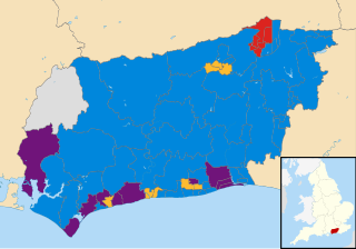
The West Sussex County Council election, 2013 took place on 2 May 2013, as part of the 2013 United Kingdom local elections. All 71 electoral divisions were up for election, which returned one county councillor each by first-past-the-post voting for a four-year term of office. At this election, the Conservative Party was seeking to retain overall control of the council, and the Liberal Democrats to maintain their position as the main opposition party.

References

  1. 1 2 UK Census (2021). "2021 Census Area Profile – Chichester Local Authority (E07000225)". Nomis. Office for National Statistics . Retrieved 5 January 2024.
  2. Report of the Commissioners Appointed to Inquire into the Municipal Corporations in England and Wales: Appendix 2. 1835. p. 715. Retrieved 27 January 2024.
  3. Kelly, S.E. (1994). Hobbs, Mary (ed.). Chichester Cathedral: An Historic Survey. Chichester: Phillimore. pp. 1–10. ISBN   0-85033-924-3.
  4. "The English Non-metropolitan Districts (Definition) Order 1972", legislation.gov.uk , The National Archives, SI 1972/2039, retrieved 31 May 2023
  5. "The English Non-metropolitan Districts (Names) Order 1973", legislation.gov.uk , The National Archives, SI 1973/551, retrieved 31 May 2023
  6. 1 2 "No. 46255". The London Gazette . 4 April 1974. p. 4401.
  7. "Council minutes, 17 May 2023". Chichester District Council. Retrieved 8 October 2023.
  8. Stephenson, Jo (7 March 2012). "Shepherd moves up to chief". Local Government Chronicle. Retrieved 8 October 2023.
  9. "Local Government Act 1972", legislation.gov.uk , The National Archives, 1972 c. 70, retrieved 31 May 2023
  10. "Election Maps". Ordnance Survey. Retrieved 25 July 2023.
  11. "Members". South Downs National Park Authority. Retrieved 17 August 2023.
  12. Dunn, Karen (18 May 2023). "New Lib Dem leader at Chichester District Council outlines his administration's priorities". Sussex World. Retrieved 26 January 2024.
  13. "Compositions calculator". The Elections Centre. Retrieved 9 September 2022.
  14. Colin Rallings; Michael Thrasher (June 2015). "Chichester District Council Election Results 1973-2011" (PDF). The Elections Centre, Plymouth University.
  15. "Chichester". BBC News Online . Retrieved 7 February 2010.
  16. "Council minutes". Chichester District Council. Retrieved 22 July 2022.
  17. "Local elections 2023: live council results for England". The Guardian.
  18. "Your councillors by party". Chichester District Council. Retrieved 27 January 2024.
  19. "The Chichester (Electoral Changes) Order 2017", legislation.gov.uk , The National Archives, SI 2017/475, retrieved 27 January 2024
  20. "Your councillors". Chichester District Council. Retrieved 7 September 2019.
  21. "Declaration of Result of Poll: Chichester District Council Election of a District Councillor for Chichester East Ward on Thursday 24 June 2021".
  22. Historic England. "East Pallant House (Chichester Rural District Council Offices) (Grade II) (1026811)". National Heritage List for England . Retrieved 27 January 2024.
  23. "Chichester". Office for National Statistics.
  24. "Chichester". Ordnance Survey.
  25. "Parish and town council addresses". Chichester District Council. Retrieved 27 January 2024.

50°50′13″N0°46′48″W / 50.837°N 0.780°W / 50.837; -0.780