Tandridge District

Last updated

Tandridge District
Croydon Road, Caterham - geograph.org.uk - 829844.jpg
Caterham, the largest town in Tandridge
Motto(s): 
Concordia
(Latin: Harmony)
Tandridge UK locator map.svg
Tandridge shown within Surrey
Sovereign state United Kingdom
Constituent country England
Region South East England
Non-metropolitan county Surrey
Status Non-metropolitan district
Admin HQ Oxted
Incorporated1 April 1974
Government
  TypeNon-metropolitan district council
  BodyTandridge District Council
  Leadership Alternative - Sec.31
   MPs Claire Coutinho
Area
  Total95.8 sq mi (248.2 km2)
  Rank134th (of 296) Highest point  : Botley Hill
Population
 (2021)
  Total88,143
  Rank268th (of 296)
  Density920/sq mi (360/km2)
  Ethnicity [1]
93.8% White
2.0% S.Asian
1.8% Black
1.4% Mixed Race
Time zone UTC0 (GMT)
  Summer (DST) UTC+1 (BST)
ONS code 43UK (ONS)
E07000215 (GSS)
OS grid reference TQ3954252860

Tandridge is a local government district in east Surrey, England. Its council is based in Oxted, although the largest settlement is Caterham; other notable settlements include Warlingham, Godstone and Lingfield. In mid-2019, the district had an estimated population of 88,129.

Contents

Tandridge borders the Borough of Reigate and Banstead to the west, the London Borough of Croydon to the north, the London Borough of Bromley to the north-east, the Sevenoaks District of Kent to the east, the Wealden District of East Sussex to the south-east, the Mid Sussex District of West Sussex to the south and the Borough of Crawley, also in West Sussex, to the south-west.

The district contains parts of the North Downs Area of Outstanding Natural Beauty and the Weald. It also contains several woodlands and some open heathland. Elevations above sea level range from 267 m (876 ft) at Botley Hill, in the North Downs near Oxted, to 42 m (138 ft) near Edenbridge. [2]

History

The district was formed on 1 April 1974 under the Local Government Act 1972. The new district covered the whole area of two former districts, which were both abolished at the same time: [3]

The new district was named after the medieval Tandridge Hundred, which had covered a similar area. [4] [5] From the seventeenth century onwards, hundreds gradually declined in importance as administrative divisions, with their functions passing to other bodies such as the county courts. The final administrative functions of hundreds had been extinguished in 1886. [6] The Tandridge hundred was named after the hillside village and ridge of the North Downs, Tandridge.

The vast majority of the district is covered by the Metropolitan Green Belt to prevent extension of the London urban area. [7]

The district is not currently twinned, but one of its towns, Lingfield, is twinned with Plaisance-du-Touch, a commune on the outskirts of Toulouse, France. [8]

Governance

Tandridge District Council
Tandridge District Council.svg
Type
Type
History
Founded1 April 1974
Leadership
Christopher Botten,
Liberal Democrat
since 25 May 2023 [9]
Catherine Sayer,
OLRG
since 27 May 2021
David Ford
since 21 June 2021 [10]
Structure
Seats42 councillors
Political groups
Administration (18)
  Independent (10)
  OLRG (8)
Other parties (24)
  Liberal Democrats (11)
  Conservative (9)
  Independent (4)
Elections
Last election
4 May 2023
Next election
2 May 2024
Meeting place
Oxted Council offices - geograph.org.uk - 3485626.jpg
Council Offices, Station Road East, Oxted, RH8 0BT
Website
www.tandridge.gov.uk

Tandridge District Council provides district-level services. County-level services are provided by Surrey County Council. The whole district is also covered by civil parishes, which form a third tier of local government. [11]

Political control

The council has been under no overall control since 2019. It has been led since 2021 by a minority administration comprising local party the Oxted and Limpsfield Residents Group (OLRG) and some of the independent councillors.

The first election to the council was held in 1973, initially operating as a shadow authority alongside the outgoing authorities until the new arrangements came into effect on 1 April 1974. Political control of the council since 1974 has been as follows: [12] [13]

Party in controlYears
Conservative 1974–1990
No overall control 1990–1994
Conservative 1994–1995
No overall control 1995–2000
Conservative 2000–2019
No overall control 2019–present

Leadership

The leaders of the council since 2007 have been: [14]

CouncillorPartyFromTo
Gordon Keymer Conservative pre-20078 May 2016
Martin Fisher Conservative 26 May 20165 May 2019
Tony Elias Conservative 21 May 201927 May 2021
Catherine SayerOLRG27 May 2021

Composition

Following the 2023 election, the composition of the council was: [15]

PartyCouncillors
Independent 14
Liberal Democrats 11
Conservative 9
Oxted and Limpsfield Residents Group8
Total42

Of the independent councillors, four form the "Independents Group", and the other ten sit with the Oxted and Limpsfield Residents Group as the "Residents' Alliance" which forms the council's administration. [16] The next election is due in 2024.

Premises

The council is based at the Council Offices on Station Road East in Oxted (the building is actually in the parish of Limpsfield). The building was purpose-built for the council in 1989 on the site of the old Godstone Rural District Council's headquarters. [17]

Elections

Since the last full review of boundaries in 2000, the council has comprised 42 councillors representing 20 wards, with each ward electing one, two or three councillors. Elections are held three years out of every four, with roughly a third of the council elected each time to serve a four year term. Surrey County Council elections are held in the fourth year of the cycle when there are no district council elections. [18]

Parishes

The entire district is divided into civil parishes. The former Caterham and Warlingham Urban District was an unparished area until 2000, when six parishes were created covering that area: Caterham-on-the-Hill, Caterham Valley, Chaldon, Warlingham, Whyteleafe and Woldingham. [19] None of Tandridge's parish councils are styled as a "town council". [20] The Royal Mail classes Caterham, Godstone, Lingfield, Oxted, Warlingham, and Whytleafe as post towns.

Tandridge Civil Parishes.png

Town, village or neighbourhoodParish 1Parish 2
Bletchingley which includes South Park, Brewer Street and Warwick Wold Bletchingley
Burstow which includes Smallfield** and Weatherhill Burstow
Caterham Caterham on the Hill Caterham Valley
Chaldon Chaldon
Chelsham Chelsham and Farleigh
Crowhurst Crowhurst
Dormansland which includes Dormans Park and Haxted Dormansland
Farleigh which includes Fickleshole Chelsham and Farleigh
Felbridge which includes Domewood Felbridge
Godstone which includes South Godstone*, Tyler's Green, Church Town, Tilburstow and Blindley Heath* Godstone
Horne which includes Newchapel and Whitewood Horne
Limpsfield which includes Limpsfield Chart*, Paines Hill and Langhurst Limpsfield
Lingfield which includes Felcourt Lingfield
Outwood Outwood
Oxted which includes Hurst Green* and Holland Oxted
Nutfield which includes South Nutfield* and Ridge Green Nutfield
Tandridge which includes Crowhurst Lane End Tandridge
Tatsfield Tatsfield
Titsey Titsey
Warlingham which includes Hamsey Green* Warlingham
Whyteleafe Whyteleafe
Woldingham which includes Woldingham Garden Village Woldingham

[21]

Each civil parish is named after one of its towns or villages which has been established around an Anglican church. All other settlements/neighbourhoods with their own Anglican church or chapel and therefore traditionally in England defined as "a village" are marked with an asterisk. A double asterisk indicates the locality has a church hall used as a Church of England church. [22] One chapel in Limpsfield ecclesiastical parish and civil parish has no adjoining settlement, in Staffhurst Wood.

Arms

Coat of arms of Tandridge District
Tandridge Escutcheon.png
Notes
Granted 17 March 1977
Crest
Upon a mural crown Or a grasshopper Vert.
Escutcheon
Gules three bezants each charged with an estoile of eight rays also Gules.
Supporters
On either side a griffin Or holding a sword erect Proper the quillons formed of a vol Or the pommel Azure.
Motto
Concordia (Harmony) [23]
Badge
Four Tau crosses joined in cross at the foot Or.

See also

Related Research Articles

<span class="mw-page-title-main">Warlingham</span> Village in Surrey, England

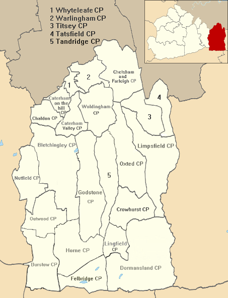
Warlingham is a village and civil parish in the Tandridge district of Surrey, England, 14 miles (23 km) south of London and 22 miles (35 km) east of Guildford. Warlingham is the centre of a civil parish that includes Hamsey Green to the north. Caterham is 2 miles (3.2 km) to the southwest.

<span class="mw-page-title-main">Oxted</span> Town and civil parish in Surrey, England

Oxted is a town and civil parish in the Tandridge district of Surrey, England, at the foot of the North Downs. It is 9 miles (14 km) south south-east of Croydon in Greater London, 9 miles (14 km) west of Sevenoaks in Kent, and 9 miles (14 km) north of East Grinstead in West Sussex.

<span class="mw-page-title-main">East Surrey (UK Parliament constituency)</span> UK Parliament constituency since 1918

East Surrey is a constituency represented in the House of Commons of the UK Parliament since 2019 by Claire Coutinho, a Conservative serving as Secretary of State for Energy Security and Net Zero. The seat covers an affluent area in the English county of Surrey.

<span class="mw-page-title-main">Caterham</span> Town in Surrey, England

Caterham is a town in the Tandridge District of Surrey, England. The town is administratively divided into two: Caterham on the Hill, and Caterham Valley, which includes the main town centre in the middle of a dry valley but rises to equal heights to the south. The town lies close to the A22, 21 miles from Guildford and 6 miles south of Croydon, in an upper valley cleft into the dip slope of the North Downs. Caterham on the Hill is above the valley to the west.

<span class="mw-page-title-main">Chaldon</span> Human settlement in England

Chaldon is a village and civil parish in the Tandridge District of Surrey, England. The village is situated high on the North Downs, immediately west of Caterham and 15.8 miles (25.4 km) south of Charing Cross, the traditional centre of London.

<span class="mw-page-title-main">Godstone</span> Human settlement in England

Godstone is a village and civil parish in the Tandridge District of Surrey, England. It is 6 miles (9.7 km) east of Reigate, 3 miles (4.8 km) west of Oxted, 22 miles (35 km) east of Guildford and 18 miles (29 km) south of London. Close to the North Downs and Blindley Heath. The Greensand Way and the North Downs Way both pass through Godstone.

<span class="mw-page-title-main">Whyteleafe</span> Human settlement in England

Whyteleafe is a village in the district of Tandridge, Surrey, England, with a few streets falling inside the London Borough of Croydon. The village, in a dry valley of the North Downs, has three railway stations. Neighbouring villages and towns include Woldingham, Caterham, Coulsdon, Warlingham, and Kenley. To the west are Kenley Aerodrome, Kenley Common, Coxes Wood, and Blize Wood. To the east are Riddlesdown, the Dobbin and Marden Park.

<span class="mw-page-title-main">Coulsdon and Purley Urban District</span> Local government district in Surrey, England

Coulsdon and Purley Urban District was a local government district in northeast Surrey from 1915 to 1965. The local authority was Coulsdon and Purley Urban District Council. The former area of the district is now mostly part of the London Borough of Croydon in Greater London, with parts in the Tandridge District and the Borough of Reigate and Banstead in Surrey.

<span class="mw-page-title-main">Limpsfield</span> Human settlement in England

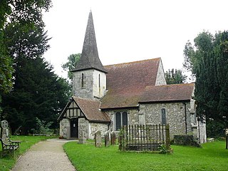
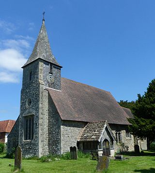
Limpsfield is a village and civil parish in Surrey, England, at the foot of the North Downs close to Oxted railway station and the A25. The composer Frederick Delius and orchestral conductor Sir Thomas Beecham are buried in the village churchyard and there are 89 listed buildings.

<span class="mw-page-title-main">London Traffic Area</span>

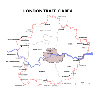
The London Traffic Area was established by the London Traffic Act 1924 to regulate the increasing amount of motor traffic in the London area. The LTA was abolished in 1965 on the establishment of the Greater London Council.

<span class="mw-page-title-main">Farleigh, Surrey</span> Human settlement in England

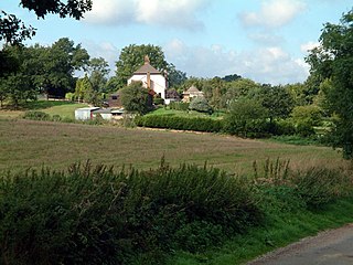
Farleigh is a village and former civil parish, now in the parish of Chelsham and Farleigh in the Tandridge district of Surrey, England. It is located in the North Downs AONB and the Metropolitan Green Belt, 4.5 miles (7.2 km) south east of Croydon, 13.4 miles (21.6 km) south of London and 25 miles (40 km) WNE of Surrey's county town, Guildford. In 1961 the parish had a population of 1285.

<span class="mw-page-title-main">Chelsham and Farleigh</span> Human settlement in England

Chelsham and Farleigh is a civil parish in the Tandridge District of Surrey, England. The parish is high on the North Downs and centred 14 miles (23 km) south-southeast of central London and it adjoins the Greater London boundary; it is a predominantly rural/wooded parish aside from minority of land used for homes and gardens. Other than the villages of Chelsham and Farleigh, the parish also includes the hamlet of Fickleshole. The parish was created on 1 April 1969 as an amalgamation of its two named small villages.

<span class="mw-page-title-main">Horne, Surrey</span> Village and parish in Surrey, England

Horne is a rural village and civil parish in the District of Tandridge in Surrey, England. The parish includes the hamlet of Newchapel, where the British Wildlife Centre is situated. Eastern fields forming a narrow part of the parish are split by the A22 road, a main road to East Grinstead.

Tandridge Hundred was a hundred in Surrey, England. It comprised areas in the Tandridge District, the easternmost part of the county, bordering Kent, West Sussex and the 1965-created county of Greater London.

Godstone Rural District was a rural district in Surrey, England from 1894 to 1974, covering an area in the south-east of the county.

The 2019 Tandridge District Council election took place on 2 May 2019 to elect one third of members to Tandridge District Council in England coinciding with other local elections

<span class="mw-page-title-main">2023 Tandridge District Council election</span> 2023 English local election

The 2023 Tandridge District Council election took place on 4 May 2023 to elect 14 members (one-third) of Tandridge District Council in Surrey, England. This was on the same day as other local elections across England.

References

  1. Office for National Statistics: Neighbourhood Statistics: Tandridge
  2. Local Authority Map. Accessed 2012-04-23
  3. "The English Non-metropolitan Districts (Definition) Order 1972", legislation.gov.uk , The National Archives, SI 1972/2039, retrieved 31 May 2023
  4. "The English Non-metropolitan Districts (Names) Order 1973", legislation.gov.uk , The National Archives, SI 1973/551, retrieved 31 May 2023
  5. "Tandridge Hundred". A Vision of Britain through Time. GB Historical GIS / University of Portsmouth. Retrieved 21 July 2023.
  6. Riot (Damages) Act 1886 (49 & 50 Vict. c. 38), s.2
  7. London Green Belt Council http://londongreenbeltcouncil.org.uk/threats_map/
  8. District Council link to external website. Accessed 2012-04-23
  9. "Council minutes, 25 May 2023". Tandridge District Council. 25 May 2023. Retrieved 21 July 2023.
  10. O'Brien, Christy (30 March 2021). "Tandridge District Council appoints first permanent chief exec since 2019". In Your Area. Retrieved 21 July 2023.
  11. "Local Government Act 1972", legislation.gov.uk , The National Archives, 1972 c. 70, retrieved 31 May 2023
  12. "Compositions calculator". The Elections Centre. 4 March 2016. Retrieved 10 August 2022.
  13. "Tandridge". BBC News Online . Retrieved 9 March 2015.
  14. "Council minutes". Tandridge District Council. Retrieved 17 July 2022.
  15. "Local elections 2023: live council results for England". The Guardian.
  16. "Your councillors by political grouping". Tandridge District Council. Retrieved 21 July 2023.
  17. "We are coming to Oxted". Dorking and Leatherhead Advertiser. 4 May 1989. p. 42. Retrieved 18 July 2022. We will be moving into the offices in July...
  18. "The District of Tandridge (Electoral Changes) Order 1999", legislation.gov.uk , The National Archives, SI 1999/2480, retrieved 21 July 2023
  19. "The Tandridge (Parishes) Order 1999" (PDF). Local Government Boundary Commission for England. The National Archives. Retrieved 21 July 2023.
  20. "Parish Councils". Tandridge District Council. Retrieved 21 July 2023.
  21. Map created by Ordnance Survey, courtesy of English Heritage
  22. Church of England website - ecclesiastical parish finder
  23. "Tandridge District Council (Surrey)". Civic Heraldry of England. Retrieved 31 May 2022.

51°15′26″N0°00′00″E / 51.2573°N 0.0000°E / 51.2573; 0.0000