Bouldon

Last updated

Bouldon
  • Boulden
Bouldon 2012 village centre.JPG
Stone farm buildings, at Bouldon Farm, in the centre of Bouldon. The lane crosses the Pye Brook, which flows through the hamlet.
Shropshire UK location map.svg
Red pog.svg
Bouldon
Location within Shropshire
OS grid reference SO545851
  London 151 miles (243 km)
Civil parish
Unitary authority
Ceremonial county
Region
Country England
Sovereign state United Kingdom
Post town CRAVEN ARMS
Postcode district SY7
Dialling code 01584
Police West Mercia
Fire Shropshire
Ambulance West Midlands
UK Parliament
List of places
UK
England
Shropshire
52°27′43″N2°40′12″W / 52.462°N 2.670°W / 52.462; -2.670

Bouldon is a hamlet in Shropshire, England. It lies in the civil parish of Diddlebury.

Contents

The hamlet comprises approximately 14 houses, a number of agricultural buildings and a public house named the "Tally Ho". [1] It is 8.5 miles (13.7 km) by road northeast of the market town of Ludlow.

Etymology

In the Domesday Book of 1086 it was written as "Bolledone". In 1166 it was written as "Bullardone". The second part of the name likely comes from the Old English word for hill ("dun") whilst the meaning of the first part is unknown. [2] It could be either from the Old English word for bullocks ("bula"); a personal name: "Ballu" or "Bulla"; or the name of a tribe: "Bulwana". [3] It has been conjectured by some that the various earlier spellings and uncertain origin of the name is because a settlement relocated to where Bouldon today is. [4]

The place name is also written as Boulden [5] [6] and this spelling is used for the habitational surname that originates from the hamlet. [7] This indicates also an alternative origin for the second part of the name, the Old English word for a valley "denu". [8]

History

The Domesday Book of 1086 records 4 households existing at the time. Bouldon was at that time part of Culvestan hundred, [9] a Saxon hundred that was in the early 12th century replaced by Munslow.

From the late 11th century to 1884, Bouldon was a detached part of Holdgate parish. Its transfer to Diddlebury parish was effectively a return to the situation prior to the change in the 11th century. [10] (Bouldon was transferred to the Church of England's ecclesiastical parish of Diddlebury, from Holdgate, only in 1921.) [11]

Bouldon used to be a more populous place, as was this rural area of Shropshire generally, and was a place to stop en route between Ludlow and Bridgnorth. The route from Bouldon to Ludlow was a turnpike road between 1794 and 1873. [10] The main road between the towns of Ludlow and Bridgnorth no longer passes through the hamlet; it today takes a route to the east of Brown Clee Hill instead.

Bouldon Mill is Grade II Listed [12] former mill building in the hamlet, now a residence/therapy centre, which still has the Coalbrookdale iron-cast water wheel [3] (using the flow of the Pye Brook) and inside workings. The stone building was built in 1790 but there was a timber mill beforehand built in 1611. [13] It may have operated as a mill as late as the 1930s. [14]

There is also a house on the site where a small church, built from corrugated iron, used to be. [3] This small church, or chapel, was called All Saints and was erected by the rector of the Church of England's Holdgate parish (which Bouldon was part of until 1921) in 1873. It was demolished in the 1980s, having become dilapidated. [11]

Bouldon had a charcoal-fuelled ironworks of its own in the 17th and 18th centuries, producing pig iron. It was important during the English Civil War. On 28 September 1643, Charles I authorised payment of £965 10s. to the iron master, Francis Walker, for manufacture of artillery and ammunition delivered to the Royalist forces at Shrewsbury, Bridgnorth and Worcester. [15] It closed around 1795 and only a tree covered slag heap remains. [3]

The Tally Ho Inn was first licensed in 1844. [10] It closed in 2006, but reopened in 2012 as a locally-owned freehouse, and retains its country character and serves several local real ales. [16]

In Bouldon, and also in nearby Peaton and Peatonstrand, weather-board houses were constructed in the 1950s by the Church Commissioners, who bought the Holder Estate in 1942. [11] Of the four in Bouldon, two are currently derelict. The ones in Bouldon are named Cedarwood Houses.

Listed buildings

Crossing the Pye Brook from Peaton, the first (white) building is the Tally Ho public house. Bouldon 2012 Tally Ho.JPG
Crossing the Pye Brook from Peaton, the first (white) building is the Tally Ho public house.

There are 5 Listed buildings in Bouldon, all Grade II: the early 19th century Wynetts Bank Cottage, [17] the 17th / 19th century Bouldon Farmhouse, [18] two separate barns near Bouldon Farmhouse, [19] [20] and Bouldon Mill (as described in the history section). [12]

Geography

Cattle crossing the Bouldon to Tugford lane. Cattle crossing the lane near Bouldon - geograph.org.uk - 200696.jpg
Cattle crossing the Bouldon to Tugford lane.

Bouldon lies on the Pye Brook (which is known as the Clee Brook immediately upstream of Bouldon), at approximately 145 metres (476 ft) above sea level, and is located on the eastern boundary of the relatively flat Corvedale, where the valley meets the upland Clee Hills. [21]

Nearby localities

A mile (1.6 km) to the northeast, in the neighbouring parish of Heath, is a notable historic chapel. A mile to the north is Broncroft Castle, a medieval fortified manor house, extensively renovated in the 19th century. [22] A mile to the west, on the lane to Diddlebury, is the hamlet of Peaton, with Peatonstrand roughly half-way.

Diddlebury is a larger village, with a parish church and a primary school, 2.75 miles (4.43 km) to the west and on the other side of the River Corve. Craven Arms is 8.0 miles (12.9 km) by road to the west, and Church Stretton is 11 miles (18 km) by road to the northwest.

Area of Outstanding Natural Beauty

Bouldon lies partially within the Shropshire Hills Area of Outstanding Natural Beauty (AONB). The boundary runs along the lane to Peaton/Diddlebury and along the lane to Broncroft/Tugford, with the southern and eastern buildings of the hamlet falling within the AONB.

Transport

The only public transport provided currently in Bouldon are buses to Ludlow in the morning, returning in the late afternoon. These services (176 and 715) are provided mainly for travel to and from schools and colleges, and only run on schooldays. [23]

The nearest railway stations are Ludlow and Craven Arms, both approximately 8 miles (13 km) away by road.

See also

Related Research Articles

<span class="mw-page-title-main">Ludlow</span> Town and civil parish in Shropshire, England

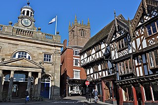
Ludlow is a market town and civil parish in Shropshire, England. It is located 28 miles (45 km) south of Shrewsbury and 23 miles (37 km) north of Hereford, on the A49 road which bypasses the town. The town is near the confluence of the rivers Corve and Teme.

Shropshire was established during the division of Saxon Mercia into shires in the 10th century. It is first mentioned in 1006. After the Norman Conquest it experienced significant development, following the granting of the principal estates of the county to eminent Normans, such as Roger De Montgomery and his son Robert de Bellême.

<span class="mw-page-title-main">Abdon, Shropshire</span> Human settlement in England

Abdon is an upland village and former civil parish, now in the parish of Abdon and Heath, in Shropshire, England. In 2011 the parish had a population of 199. It is in the Clee Hills.

<span class="mw-page-title-main">Aston Botterell</span> Human settlement in England

Aston Botterell is a village and small civil parish in the county of Shropshire, West Midlands, England. The village lies 8 miles (13 km) south-west of the market town of Bridgnorth and 10 miles (16 km) north-east of the town of Ludlow. The nearest main roads are the B4364 and the A4117. According to the 2001 census, the civil parish had a population of 74. The area's economy is still largely based on agriculture, though many residents travel up to 12 miles (19 km) to work in other sectors such as the service and manufacturing industries.

<span class="mw-page-title-main">Bitterley</span> Human settlement in England

Bitterley is a village and civil parish in Shropshire, England. According to the 2001 census the parish had a population of 802, increasing to 902 at the 2011 Census. The village is about 4 miles (6.4 km) east of Ludlow on the western slopes of Titterstone Clee Hill. Bitterley is the location for Bitterley Court about 0.62 miles (1.00 km) east of the modern village. Nearby to the east, is the small hamlet of Bedlam.

<span class="mw-page-title-main">Ludford, Shropshire</span> Village in Shropshire, England

Ludford is a small village and civil parish in south Shropshire, England. The parish is situated adjacent to the market town of Ludlow and was, until 1895, partly in Herefordshire.

<span class="mw-page-title-main">Stanton Lacy</span> Human settlement in England

Stanton Lacy is a small village and geographically large civil parish located in south Shropshire, England, 3 miles (4.8 km) north of Ludlow.

<span class="mw-page-title-main">Sibdon Carwood</span> Human settlement in England

Sibdon Carwood is a hamlet and parish in Shropshire, England. To the east is the town of Craven Arms.

<span class="mw-page-title-main">Diddlebury</span> Human settlement in England

Diddlebury is a small village and large civil parish in Shropshire, England. It is situated in the Corvedale on the B4368 road about 5 miles (8 km) north east of Craven Arms. The population of the Civil Ward in 2011 was 670.

<span class="mw-page-title-main">Corfton</span> Human settlement in England

Corfton is a small village in Shropshire, England, located 4.5 miles (7.2 km) east of Craven Arms and 7.5 miles (12.1 km) north of Ludlow, the two nearest towns.

<span class="mw-page-title-main">Cleobury North</span> Human settlement in England

Cleobury North is a civil parish and small village in south east Shropshire, England. It is situated on the B4364 southwest of the market town of Bridgnorth. To the north is the village of Ditton Priors and to the west is Brown Clee Hill, the county's highest hill.

<span class="mw-page-title-main">Peaton</span> Human settlement in England

Peaton is a hamlet in the civil parish of Diddlebury in Shropshire, England.

<span class="mw-page-title-main">Holdgate</span> Human settlement in England

Holdgate is a small village and former civil parish, now in the parish of Abdon and Heath, in the Shropshire district, in the ceremonial county of Shropshire, England. Its name is taken from its Norman lord Helgot who owned the village in 1086 along with 17 other parishes in Shropshire. In 1931 the parish had a population of 47.

<span class="mw-page-title-main">Stanton Long</span> Human settlement in England

Stanton Long is a small village and civil parish situated in the district of Corve Dale, Shropshire, England. It is one of three parishes in the local area, including Easthope and Shipton. In the National Gazetteer of Great Britain and Ireland 1868, it was described as:

<span class="mw-page-title-main">Tugford</span> Human settlement in England

Tugford is a village and former civil parish, now in the parish of Abdon and Heath, in the Shropshire district, in the ceremonial county of Shropshire, England. It lies between Bouldon and Holdgate, on the boundary of the relatively flat Corvedale and the upland Clee Hills.

<span class="mw-page-title-main">Holy Trinity Church, Holdgate</span> Church in Shropshire, England

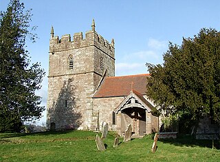
Holy Trinity Church is in the village of Holdgate, Shropshire, England. It is an active Anglican parish church in the deanery of Ludlow, the archdeaconry of Ludlow, and the diocese of Hereford. Its benefice is united with those of St Peter, Diddlebury, Broadstone Church, St Michael, Munslow, and St Catherine, Tugford. The church is recorded in the National Heritage List for England as a designated Grade I listed building. It stands in the former southwest bailey of Holdgate Castle.

<span class="mw-page-title-main">Munslow (hundred)</span>

Munslow is a hundred of Shropshire, England. It was formed with the amalgamation of the Anglo-Saxon hundreds of Patton and Culvestan during the reign of Henry I. Hundreds in England had various judicial, fiscal and other local government functions, their importance gradually declining from the end of manorialism to the latter part of the 19th century.

<span class="mw-page-title-main">Middleton, Bitterley</span> Human settlement in England

Middleton is a small village in south Shropshire, England. It is located 2.5 miles (4.0 km) northeast of Ludlow town centre, on the B4364 road, in the civil parish of Bitterley.

Diddlebury is a civil parish in Shropshire, England. It contains 40 listed buildings that are recorded in the National Heritage List for England. Of these, three are at Grade II*, the middle of the three grades, and the others are at Grade II, the lowest grade. The parish contains the village of Diddlebury and smaller settlements including Bouldon, Corfton, and Peaton, and is almost entirely rural. Most of the listed buildings are houses, cottages, farmhouses and farm buildings, many of which are basically timber framed. The other listed buildings include a church with Saxon origins, a country house developed from a medieval castle, a former manor house, a Georgian country house and associated structures, a corn mill converted into a house, and a war memorial.

References

  1. The Tally Ho
  2. Mills, David (2011) A Dictionary of British Place Names OUP Oxford
  3. 1 2 3 4 Raven, Michael A Guide To Shropshire (2005) p 32
  4. Poulton-Smith, Anthony (2009) Shropshire Place Names p 25
  5. GENUKI Gregory's 1824 Shropshire Gazetteer Appendix
  6. Philip's Navigator Britain (2011)
  7. Oxford Dictionary of Family Names Boulden
  8. Surname Database Boulden
  9. Open Domesday Archived 14 July 2014 at the Wayback Machine Bouldon
  10. 1 2 3 British History Online Bouldon
  11. 1 2 3 Oliver, Marina (2006) Castles and Corvedale
  12. 1 2 British Listed Buildings Bouldon Mill
  13. Bouldon Mill Sanctuary Archived 16 July 2012 at archive.today – about us
  14. Shropshire Star Pictures from the Past: Bouldon Mill
  15. Hamilton, William Douglas, ed. (1887). Calendar of State Papers, Domestic Series, of the Reign of Charles I, 1641-43. London: HMSO. p. 488. Retrieved 23 April 2015.
  16. Shropshire pub survey Bouldon
  17. British Listed Buildings Wynetts Bank Cottage.
  18. British Listed Buildings Bouldon Farmhouse
  19. British Listed Buildings Barn Approximately 20 Metres to North East of Bouldon Farmhouse
  20. British Listed Buildings Barn Approximately 40 Metres to East of Bouldon Farmhouse
  21. Ordnance Survey mapping
  22. "Broncroft Castle". Pastscape. Retrieved 14 June 2011.
  23. Shropshire Council Archived 25 September 2012 at the Wayback Machine Bouldon bus services