Bromfield, Shropshire

Last updated

Bromfield
Teme River near Bromfield - geograph.org.uk - 31469.jpg
The River Teme at Bromfield, Shropshire
Shropshire UK location map.svg
Red pog.svg
Bromfield
Location within Shropshire
Population277 (2011)
OS grid reference SO479769
Civil parish
  • Bromfield
Unitary authority
Ceremonial county
Region
Country England
Sovereign state United Kingdom
Post town LUDLOW
Postcode district SY8
Dialling code 01584
Police West Mercia
Fire Shropshire
Ambulance West Midlands
UK Parliament
List of places
UK
England
Shropshire
52°23′17″N2°45′54″W / 52.388°N 2.765°W / 52.388; -2.765

Bromfield is a village and civil parish in Shropshire, England.

Contents

According to the 2001 census it had a population of 306, which had fallen to 277 at the 2011 census. [1]

Location

Bromfield is located near the market town of Ludlow, two miles (3 km) northwest of the town centre, on the A49 road. The A4113 road (to Knighton) has its eastern end in Bromfield, at its junction with the A49.

The village is situated near the confluence of the River Teme and River Onny. The latter splits the village into two, with the church and many of the older buildings to the west and the recently redeveloped business area to the east (towards Ludlow). A bridge takes the main road over the river.

History

The manor of Bromfield, and separately Bromfield Priory, are recorded in the Domesday Book of 1086, then still falling within the Saxon hundred of Culvestan, [2] which was abolished in the reign of Henry I; Bromfield then came within Munslow hundred. It was a large and well-populated manor. The parish at this time extended beyond the present-day boundaries, to the north (with a detached part at Halford existing into the 19th century) and the south (another detached part, near Ashford Bowdler).

In 1884 it expanded significantly by taking in a large part of the southern portion of Stanton Lacy's parish; in 1934 another significant boundary change took place, with a large part (on both sides of the River Teme, and including a small part of the 1884 transfer from Stanton Lacy) transferred to Ludlow. [3] Circa 1967 the borders of Ludford, Bromfield and Ludlow were re-aligned in the Whitcliffe area.

1987 saw a small area, containing the places of Wigley and Fishmore, transferred from East Hamlet which was being dissolved at the time. The effect of the boundary changes caused by this dissolution was the creation of a second boundary with Ludford, with Ludlow now encircled by the two parishes of Ludford and Bromfield.

Much of the parish, as well as the neighbouring parish of Stanton Lacy, is part of the Earl of Plymouth's Oakly Park Estate. Oakly Park is now the Plymouth family seat.

St Mary's parish church. Church of St Mary the Virgin, Bromfield - geograph.org.uk - 31473.jpg
St Mary's parish church.

The village church is dedicated to St. Mary the Virgin and is a grade I listed building. [4] There was, until the Dissolution of the Monasteries, a priory at Bromfield.

Amenities

Three-quarters of Ludlow Racecourse and the Ludlow Golf Club are located in the parish, to the northeast of the village. The Welsh Marches Line passes through the parish, between the village and the racecourse. A level crossing and manned signal box still exist, but the station once sited here closed in 1958.

The village now boasts a post office (open Monday-Friday only), [5] a hotel/restaurant/bar, a large local food centre, a smaller restaurant/cafe, and a garden/plant centre. These are all located adjacent to one another in a recently redeveloped business area by the A49 road.

Islabikes were based in the business area but moved to nearby Ludford; they manufacture specialist bicycles, in particular for children.

National Cycle Network route 44 passes through the village, on its way between Bishop's Castle and Ludlow. It passes under the A49 by a subway, an unusual feature for a village in Shropshire.

People associated with Bromfield

See also

Related Research Articles

<span class="mw-page-title-main">Ludlow</span> Town and civil parish in Shropshire, England

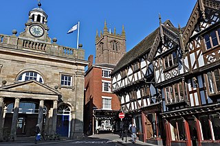
Ludlow is a market town and civil parish in Shropshire, England. It is located 28 miles (45 km) south of Shrewsbury and 23 miles (37 km) north of Hereford, on the A49 road which bypasses the town. The town is near the confluence of the rivers Corve and Teme.

Shropshire was established during the division of Saxon Mercia into shires in the 10th century. It is first mentioned in 1006. After the Norman Conquest it experienced significant development, following the granting of the principal estates of the county to eminent Normans, such as Roger De Montgomery and his son Robert de Bellême.

<span class="mw-page-title-main">Shropshire Hills National Landscape</span> Area of Outstanding Natural Beauty in England

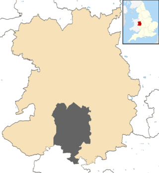
The Shropshire Hills National Landscape is a designated Area of Outstanding Natural Beauty (AONB) in Shropshire, England. It is located in the south of the county, extending to its border with Wales. Designated in 1958, the area encompasses 802 square kilometres (310 sq mi) of land primarily in south-west Shropshire, taking its name from the upland region of the Shropshire Hills. The A49 road and Welsh Marches Railway Line bisect the area north–south, passing through or near Shrewsbury, Church Stretton, Craven Arms and Ludlow.

<span class="mw-page-title-main">Ashford Bowdler</span> Human settlement in England

Ashford Bowdler is a small village and civil parish in south Shropshire, England, near the county border with Herefordshire.

<span class="mw-page-title-main">Ashford Carbonell</span> Human settlement in England

Ashford Carbonell is a village and civil parish in south Shropshire, England, near the county border with Herefordshire.

<span class="mw-page-title-main">Bitterley</span> Human settlement in England

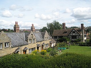
Bitterley is a village and civil parish in Shropshire, England. According to the 2001 census the parish had a population of 802, increasing to 902 at the 2011 Census. The village is about 4 miles (6.4 km) east of Ludlow on the western slopes of Titterstone Clee Hill. Bitterley is the location for Bitterley Court about 0.62 miles (1.00 km) east of the modern village. Nearby to the east, is the small hamlet of Bedlam.

<span class="mw-page-title-main">Ludford, Shropshire</span> Village in Shropshire, England

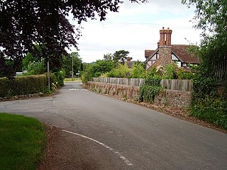
Ludford is a small village and civil parish in south Shropshire, England. The parish is situated adjacent to the market town of Ludlow and was, until 1895, partly in Herefordshire.

<span class="mw-page-title-main">Stanton Lacy</span> Human settlement in England

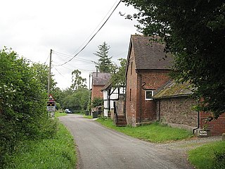
Stanton Lacy is a small village and geographically large civil parish located in south Shropshire, England, 3 miles (4.8 km) north of Ludlow.

<span class="mw-page-title-main">Sheet, Shropshire</span> Human settlement in England

Sheet is a small modern village in the parish of Ludford about 1 mile (1.6 km) from the town centre of Ludlow, Shropshire.

<span class="mw-page-title-main">A4113 road</span> Road in Eastern Wales, Herefordshire and Shropshire

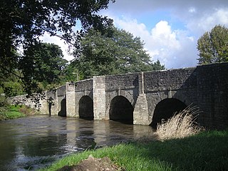
The A4113 road is a single-carriageway road that runs from Knighton in Powys to Bromfield in Shropshire, United Kingdom, passing through north Herefordshire.

Ludlow Racecourse is a thoroughbred horse racing venue located in Bromfield near Ludlow, Shropshire, England.

<span class="mw-page-title-main">Onibury</span> Human settlement in England

Onibury is a village and civil parish on the River Onny in southern Shropshire, about 4 miles (6.4 km) northwest of the market town of Ludlow.

National Cycle Network Route 44, part of the National Cycle Network, connects Shrewsbury, Shropshire with Cinderford, Gloucestershire. The part of the route from Shrewsbury to Bromfield is signed - the remainder of the route is currently unsigned.

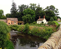
Bromfield Priory was a priory in Shropshire, England, located at Bromfield near Ludlow.

<span class="mw-page-title-main">Richard's Castle</span> Village in Herefordshire and Shropshire, England

Richard's Castle is a village, castle and two civil parishes on the border of the counties of Herefordshire and Shropshire in England. The Herefordshire part of the parish had a population of 250 at the 2011 Census, the Shropshire part, 424.

<span class="mw-page-title-main">Stanton Long</span> Human settlement in England

Stanton Long is a small village and civil parish situated in the district of Corve Dale, Shropshire, England. It is one of three parishes in the local area, including Easthope and Shipton. In the National Gazetteer of Great Britain and Ireland 1868, it was described as:

<span class="mw-page-title-main">Overton, Shropshire</span> Human settlement in England

Overton is a small village in south Shropshire, England.

East Hamlet was a civil parish situated immediately to the east and northeast of the market town of Ludlow, Shropshire. The name, which dates much further back than the creation of the civil parish, refers to a small settlement in the eastern area of Ludlow.

<span class="mw-page-title-main">Munslow (hundred)</span>

Munslow is a hundred of Shropshire, England. It was formed with the amalgamation of the Anglo-Saxon hundreds of Patton and Culvestan during the reign of Henry I. Hundreds in England had various judicial, fiscal and other local government functions, their importance gradually declining from the end of manorialism to the latter part of the 19th century.

Culvestan was a hundred of Shropshire, England. Formed during Anglo-Saxon England, it encompassed manors in central southern Shropshire, and was amalgamated during the reign of Henry I with the neighbouring hundred of Patton to form the Munslow hundred.

References

  1. "Civil Parish population 2011" . Retrieved 23 November 2015.
  2. Open Domesday Archived 12 November 2013 at the Wayback Machine Bromfield
  3. Vision of Britain Bromfield
  4. "Church of St Mary the Virgin, Bromfield". British Listed Buildings. Retrieved 26 January 2014.
  5. "Bromfield Post Office". www.ludlowfoodcentre.co.uk. Archived from the original on 5 May 2008.

Commons-logo.svg Media related to Bromfield, Shropshire at Wikimedia Commons