
Greater Somalia is a concept to unite all ethnic Somalis comprising the regions in or near the Horn of Africa in which ethnic Somalis live and have historically inhabited. The territory historically encompassed British Somaliland, Italian Somaliland, French Somaliland, the Somali Region in Ethiopia and the Northern Frontier District in Kenya. At the present, it encompasses Somalia, Somaliland, southern Djibouti, the Somali Region and Dire Dawa in Ethiopia, and the Garissa, Wajir and Mandera Counties in Kenya.

Uasin Gishu County is one of the 47 counties of Kenya, located in the former Rift Valley Province. The city of Eldoret is the county's largest population center as well as its administrative and commercial center.

The North Eastern Province is one of the former provinces in Kenya. It has a land area of 127,358.5 km2, with its capital at Garissa. Previously known as the Northern Frontier District (NFD), the North Eastern Province territory was carved out of the present-day southern Somalia during the colonial period.
The Ajuran is a Somali clan, belonging to the Samaale family of Somalis. Ajuran members largely inhabit Kenya as well as southern east Ethiopia; considerable numbers are also found in southern Somalia. Some Ajuran members settled in Mogadishu.
Wajir is the capital of the Wajir County of Kenya. It is situated in the former North Eastern Province.

Mandera is the capital of Mandera County in the former North Eastern Province of Kenya. It is situated at around 3°55′N41°50′E, near the borders with Somalia and Ethiopia.
Isiolo County is a county in the former Eastern Province of Kenya. Its population is 268,002 and its capital and largest city is Isiolo. Isiolo County is to be the first county to be developed as part of the Kenya Vision 2030 program. Other upcoming urban centres are: Garbatulla, Modogashe, Kinna, Merti and Oldonyiro.
Mado Gashi is a small remote town in Kenya. There are no large cities near Mado Gashi. It is connected by road to Isiolo, Wajir and Garissa. Mado Gashi has an unpaved airstrip. The village of Garba Tula is located 75 km west of Mado Gashi. Residential areas in Mado Gashi are called Bulas. Bula Market, Bula Digs and Bula Jua are among big Bulas found in Mado Gashi.

Baringo County is one of the 47 Counties of Kenya. It is located in the former Rift Valley Province. Its headquarters and largest town is Kabarnet. The county is home to Lake Baringo.

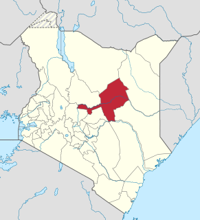
Mandera County is a county in the former North Eastern Province of Kenya. Its capital and largest town is Mandera. The county is bordered by Ethiopia to the north, by Somalia to the east and by Wajir County to the southwest. According to the 2019 census, the county has a population of 1,200,89,milion and an area of 25,939.8 km2. The main economic activity in the county is pastoralism, while others include cross-border trade with Ethiopia, artisanal mining, beekeeping and agriculture along the Dawa River.

Wajir County is a county in the former North Eastern Province of Kenya. Its capital and largest town is Wajir. The county has a population of 720,000 and an area of 55,840.6 km2. The county is bordered to the north by Ethiopia, to the northeast by Mandera County, to the east by Somalia, to the south by Garissa County, to the west by Isiolo County and to the northwest by Marsabit County. The county has six constituencies: eldas, Tarbaj, Wajir North, Wajir West, Wajir East, and Wajir South.

The districts of Kenya were divided into 262 divisions (matarafa). Divisions of Kenya were further subdivided into locations. Today's counties of Kenya are based on the merging of some of the districts on this list and since the divisions are one level under the districts they are now the sub-counties. This is because Kenya recently changed its constitution and 47 Counties emerged. Here are the divisions listed below, by district :
El Wak, also Elwak is a town in Kenya, on the International border with Somalia.

Kisii County is a county in the former Nyanza Province in southwestern Kenya. Its capital and largest town is Kisii. The county has a population of 1,266,860 people. It borders Nyamira County to the North East, Narok County to the South and Homabay and Migori Counties to the West. The county covers an area of 1,317.5 km. The county is inhabited mostly by the Gusii people.
Wajir Airport is an international airport in Wajir County, Kenya.
Ünlüce is a village in the District of Çine, Aydın Province, Turkey. As of 2010 it had a population of 183 people.
Sub-counties are the decentralised units through which county governments of Kenya will provide functions and services. Except for the parts which fall under urban areas, sub-counties will coincide with the constituencies created under article 89 of the Constitution of Kenya. Sub-counties will be headed by a sub-county administrator, appointed by a County Public Service Board.

Elgeyo-Marakwet County is one of Kenya's 47 counties. Elgeyo Marakwet County is located in the former Rift Valley Province. Its capital and largest town is Iten. It borders the counties of West Pokot to the north, Baringo County to the east, southeast and south, Uasin Gishu to the southwest and west, and Trans Nzoia to the northwest.

The involvement of the British Colony of Kenya in World War II began with the declaration of war on Nazi Germany by the British Empire in September 1939.
Ibrahim Abdi Saney is the current Member of Parliament for Wajir North Constituency. He won the general election of March 2013, slightly defeating his opponent Dr. Abdullahi of KANU. He was born and brought up In Korondille town of Buna District, Wajir County.
