The Cane River National Heritage Area is a United States National Heritage Area in the state of Louisiana. The heritage area is known for plantations featuring Creole architecture, as well as numerous other sites that preserve the multi-cultural history of the area. The heritage area includes the town of Natchitoches, Louisiana and its national historic district. Founded in 1714, it is the oldest community in the territory covered by the Louisiana Purchase. Cane River Creole National Historical Park, including areas of Magnolia and Oakland plantations, also is within the heritage area.
The park and the St. Augustine Parish (Isle Brevelle) Church in Natchez have been included as featured destinations on the state's Louisiana African American Heritage Trail.
The roughly 116,000 acres (470 km2) Cane River National Heritage Area begins just south of Natchitoches and extends south and west for about 35 miles (56 kilometers along Cane River Lake and Interstate 49 to Monette's Ferry. Other sites in the heritage area include the Kate Chopin House and the state historic sites of Los Adaes State Historic Site, Fort Jesup, and Fort St. Jean Baptiste State Historic Site.
| | This Louisiana state location article is a stub. You can help Wikipedia by expanding it. |

Natchitoches Parish is a parish located in the U.S. state of Louisiana. As of the 2020 census, the population was 37,515. The parish seat is Natchitoches. The parish was formed in 1805.
Natchez is a town in Natchitoches Parish, Louisiana, United States. The population was 597 at the 2010 census. It is part of the Natchitoches Micropolitan Statistical Area. The village and parish are part of the Cane River National Heritage Area and located on Isle Brevelle.

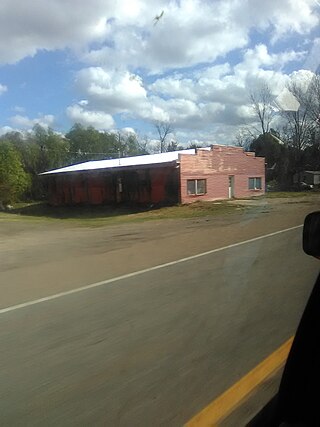
Robeline is a village in western Natchitoches Parish, Louisiana, United States. The population was 183 at the 2000 census. It is part of the Natchitoches Micropolitan Statistical Area.

Adai is an extinct Native American language that was spoken in northwestern Louisiana.

Los Adaes was the capital of Tejas on the northeastern frontier of New Spain from 1721 to 1773. It included a Franciscan mission, San Miguel de Cuellar de los Adaes, and a presidio, Nuestra Señora del Pilar de Los Adaes. The name Adaes derives from the indigenous Adai people, members of the Caddoan confederacy of Indians who were the people the missionaries aimed to convert to Christianity. The presidio and mission were established to counter French influence in Louisiana territory and defend New Spain from possible invasion or encroachment by the French. In 1763 Louisiana came under the control of Spain and the Los Adaes outpost was no longer necessary for defense. In 1773 the Spanish closed the mission and presidio and forced the population to move to San Antonio.

Established in 1994, the Cane River Creole National Historical Park serves to preserve the resources and cultural landscapes of the Cane River region in Natchitoches Parish, Louisiana. Located along the Cane River Lake, the park is approximately 63 acres and includes two French Creole cotton plantations, Oakland and Magnolia. Both plantations are complete in their historic settings, including landscapes, outbuildings, structures, furnishings, and artifacts; and they are the most intact French Creole cotton plantations in the United States. In total, 65 historic structures and over a million artifacts enhance the National Park Service mission as it strives to tell the story of the evolution of plantation agriculture through the perspective of the land owners, enslaved workers, overseers, skilled workers, and tenant farmers who resided along the Cane River for over two hundred years. This park is included as a site on the Louisiana African American Heritage Trail.

Cane River is a 30-mile-long (48 km) river formed from a portion of the Red River that is located in Natchitoches Parish, Louisiana. In the 19th and 20th centuries, it has been best known as the site of a historic Creole de couleur (multiracial) culture that has centers upon the National Historic Landmark Melrose Plantation and nearby St. Augustine Parish Church.
Marie Thérèse Coincoin, born as Coincoin, also known as Marie Thérèse dite Coincoin, and Marie Thérèse Métoyer, was a planter, slave owner, and businesswoman at the colonial Louisiana outpost of Natchitoches.

Oakland Plantation, originally known as the Jean Pierre Emmanuel Prud'homme Plantation, and also known as Bermuda, is a historic plantation in and unincorporated area of Natchitoches Parish, Louisiana. Founded as a forced-labor farm worked by enslaved Black people for White owners, it is one of the nation's best and most intact examples of a French Creole cotton plantation complex. The Oakland Plantation is now owned by the National Park Service as part of the Cane River Creole National Historical Park.

Melrose Plantation, also known as Yucca Plantation, is a National Historic Landmark located in the unincorporated community of Melrose in Natchitoches Parish in north central Louisiana. This is one of the largest plantations in the United States built by and for free blacks. The land was granted to Louis Metoyer, who had the "Big House" built beginning about 1832. He was a son of Marie Thérèse Coincoin, a former slave who became a wealthy businesswoman in the area, and Claude Thomas Pierre Métoyer. The house was completed in 1833 after Louis' death by his son Jean Baptiste Louis Metoyer. The Metoyers were free people of color for four generations before the American Civil War.

Louisiana African American Heritage Trail is a cultural heritage trail with 38 sites designated by the state of Louisiana, from New Orleans along the Mississippi River to Baton Rouge and Shreveport, with sites in small towns and plantations also included. In New Orleans several sites are within a walking area. Auto travel is required to reach sites outside the city.

St. Augustine Catholic Church and Cemetery, or the Isle Brevelle Church, is a historic Catholic parish property founded in 1829 near Melrose, Natchitoches Parish, Louisiana. It is the cultural center of the Cane River area's historic French, Spanish, Native American and Black Creole community.

Fort St. Jean Baptiste State Historic Site, or Fort des Natchitoches, in Natchitoches, Louisiana, US, is a replica of an early French fort based upon the original blueprints of 1716 by Sieur Du Tisné and company. The settlement which became the town of Natchitoches was founded in 1714 by French Canadian Louis Antoine Juchereau de St. Denis as the first permanent European settlement in the lands later encompassed by the Louisiana Purchase. In 1722, Juchereau de St. Denis in 1722 became commandant of Fort St. Jean Baptiste des Natchitoches. The fort was devised as a trading and military outpost to counter any Spanish incursions into French territory. Soon it became a center of economic significance, particularly with neighboring Caddo tribes. After 1764, Fort St. Jean was abandoned, with the transfer of Louisiana to Spain. The exact location of the fort has since been lost. In 1979, the fort was reconstructed in the vicinity of where the fort is believed to have been located. Today, the fort is an attraction within the Cane River National Heritage Area. The site is also host to living history re-enactments of what life in the fort was like in the 1750s.
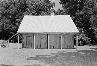
The Badin-Roque House is a historic house located along Louisiana Highway 484, about 6.6 miles (10.6 km) southeast of Natchez in the community of Isle Brevelle.

Narcisse Prudhomme Plantation, also known as Narcisse Prud'homme Plantation, Beau Fort Plantation, and St. Charles Plantation, is a historic planation house and a former plantation, located in the unincorporated community of Bermuda, Louisiana near the village of Natchez. It is one of the oldest plantations in the Cane River National Heritage Area.

Isle Brevelle is an ethnically and culturally diverse community, which began as a Native American and Louisiana Creole settlement and is located in Natchitoches Parish, Louisiana. For many years this area was known as Côte Joyeuse. It is considered the birthplace of Creole culture and remains the epicenter of Creole art and literature blending European, African, and Native American cultures. It is home to the Cane River Creole National Historical Park and part of the Louisiana African American Heritage Trail.
Anne des Cadeaux (unknown—1754), was a Native American and devout Catholic. She was enslaved but later gained her freedom. She was active in early colonial Louisiana, and was from one of the early Louisiana Creole families.
Bayou Brevelle is a series of interconnected, natural waterways totaling over 18 miles in length in Natchitoches Parish, Louisiana. Its main channel is at Old River at Montrose, Louisiana to Natchez, Louisiana near the Cane River. During heavy rains or floods, Bayou Brevelle joins the Cane River. The bayou is flanked by Interstate 49 on the west and the Cane River on the east, and is one of the many waterways on Isle Brevelle.
Brevelle Lake is a lake in Red River County, Texas. It is located near County Road 4621 and the towns of Avery, Texas and Annona, Texas. Below its dam is Shawnee Creek, which flows into the Sulphur River.

The Adai Caddo Indians of Louisiana is a state-recognized tribe in Louisiana, member of the Caddo Confederacy, and federal 501(c)(3) organization in Robeline, Louisiana. The tribe is a member of the Louisiana Office of Indian Affairs Native American Commission, and the tribe's Vice Chief Deb Garrett serves as the Commission's Secretary. Its members are descendants of the Adai people. The US Census Bureau established a State Designated Tribal Statistical Area for the Adai Caddo SDTSA, which includes Natchitoches Parish.