
Rich County is a county in the U.S. state of Utah. As of the 2010 United States Census, the population was 2,264, making it the third-least populous county in Utah. Its county seat is Randolph, and the largest town is Garden City. The county was created in 1864. It was named for an early LDS apostle, Charles C. Rich.

Sanpete County is a county in the U.S. state of Utah. As of the 2010 United States Census, the population was 27,822. Its county seat is Manti, and its largest city is Ephraim. The county was created in 1850.

Wasatch County is a county in the U.S. state of Utah. As of the 2010 United States Census, the population was 23,530. Its county seat and largest city is Heber City. The county was named for a Ute Native American word meaning mountain pass or low place in the high mountains.

Beaver is a city in, and county seat of, Beaver County in southwestern Utah, United States. The population was 3,592 at the 2020 census, up from the 2010 figure of 3,112.

Monticello is a city located in San Juan County, Utah, United States and is the county seat. It is the second most populous city in San Juan County, with a population of 1,972 at the 2010 census. The Monticello area was settled in July 1887 by pioneers from the Church of Jesus Christ of Latter-day Saints. Monticello, named in honor of Thomas Jefferson's estate, became the county seat in 1895 and was incorporated as a city in 1910.

The Territory of Utah was an organized incorporated territory of the United States that existed from September 9, 1850, until January 4, 1896, when the final extent of the territory was admitted to the Union as the State of Utah, the 45th state. At its creation, the Territory of Utah included all of the present-day State of Utah, most of the present-day state of Nevada save for Southern Nevada, much of present-day western Colorado, and the extreme southwest corner of present-day Wyoming.
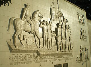
The Mormon Battalion was the only religious unit in United States military history in federal service, recruited solely from one religious body and having a religious title as the unit designation. The volunteers served from July 1846 to July 1847 during the Mexican–American War of 1846–1848. The battalion was a volunteer unit of between 534 and 559 Latter-day Saint men, led by Mormon company officers commanded by regular U.S. Army officers. During its service, the battalion made a grueling march of nearly 2,100 miles from Council Bluffs, Iowa, to San Diego, California.

The American Discovery Trail is a system of recreational trails and roads that collectively form a coast-to-coast hiking and biking trail across the mid-tier of the United States. Horses can also be ridden on most of this trail. The coastal trailheads are the Delmarva Peninsula on the Atlantic Ocean and the northern California coast on the Pacific Ocean. The trail has northern and southern alternates for part of its distance, passing through Chicago and St. Louis respectively. The total length of the trail, including both the north and south routes, is 6,800 miles (10,900 km). The northern route covers 4,834 miles (7,780 km) with the southern route covering 5,057 miles (8,138 km). It is the only non-motorized coast-to-coast trail.

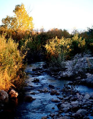
The Sevier River is a 400-mile (640 km)-long river in the Great Basin of southwestern Utah in the United States. Originating west of Bryce Canyon National Park, the river flows north through a chain of high farming valleys and steep canyons along the west side of the Sevier Plateau before turning southwest and terminating in the endorheic basin of Sevier Lake in the Sevier Desert. It is used extensively for irrigation along its course, with the consequence that Sevier Lake is usually dry.

This is the Place Heritage Park is a Utah State Park that is located on the east side of Salt Lake City, Utah, United States, at the foot of the Wasatch Range and near the mouth of Emigration Canyon. A non-profit foundation manages the park.

Downtown is the oldest district in Salt Lake City, Utah. The grid from which the entire city is laid out originates at Temple Square, the location of the Salt Lake Temple.
The Muddy River, formerly known as the Moapa River, is a short river located in Clark County, in southern Nevada, United States. It is in the Mojave Desert, approximately 60 miles (97 km) north of Las Vegas.
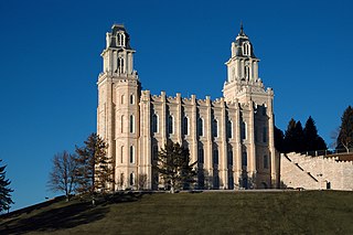
The Manti Utah Temple is the fifth constructed temple of the Church of Jesus Christ of Latter-day Saints. Located in the city of Manti, Utah, it was the third Latter-day Saint temple built west of the Mississippi River, after the Mormons' trek westward. The Manti Temple was designed by William Harrison Folsom, who moved to Manti while the temple was under construction. The temple dominates the Sanpete Valley, and can be seen from many miles. Like all Latter-day Saint temples, only church members in good standing may enter. It is one of only two remaining Latter-day Saint temples in the world where live actors are used in the endowment ceremonies ; all other temples use films in the presentation of the endowment, a practice that will end following renovations announced in 2021. It is an early pioneering example of four rooms representing the journey of life.

Emigration Canyon is a metro township and canyon in Salt Lake County, Utah, United States, located east of Salt Lake City in the Wasatch Range. Beginning at the southern end of the University of Utah, the canyon itself heads east and northeast between Salt Lake City and Morgan County. The boundaries of the metro township do not extend to the county line, nor do they encompass all of Emigration Canyon, as parts of it are within Salt Lake City. As of the 2010 census, the population was 1,568.
The This is the Place Monument is a historical monument at the This is the Place Heritage Park, located on the east side of Salt Lake City, Utah, at the mouth of Emigration Canyon. It is named in honor of Brigham Young's famous statement in 1847 that the Latter-day Saint pioneers should settle in the Salt Lake Valley. Mahonri M. Young, a grandson of Brigham Young, sculpted the monument between 1939 and 1947 at Weir Farm in Connecticut. Young was awarded $50,000 to build the monument in 1939 and he was assisted by Spero Anargyros. It stands as a monument to the Mormon pioneers as well as the explorers and settlers of the American West. It was dedicated by LDS Church President George Albert Smith on 24 July 1947, the hundredth anniversary of the pioneers entering the Salt Lake Valley. It replaced a much smaller monument located nearby.

Clarion is a ghost town in Sanpete County, Utah, United States, 5 miles (8.0 km) southwest of Gunnison. Clarion was the site of an early-twentieth century experiment in Jewish rural living. The Clarion site totaled 6,085 acres, and was five miles from north to south along the Sevier River and 3 miles (4.8 km) wide. The area today is in the Centerfield, Utah postal district.

The Mojave Road, also known as Old Government Road, is a historic route and present day dirt road across what is now the Mojave National Preserve in the Mojave Desert in the United States. This rough road stretched 147 miles (237 km) from Beale's Crossing, to Fork of the Road location along the north bank of the Mojave River where the old Mojave Road split off from the route of the Old Spanish Trail/Mormon Road.

The Dolores Doré Eccles Broadcast Center is headquarters of three broadcast stations and a statewide educational consortium. The center houses KUED, KUER, KUEN and the Utah Education Network. The facility is northeast of the Jon M. Huntsman Center and southwest of the Huntsman Cancer Institute on the University of Utah campus in Salt Lake City.
The Piute Pass Archeological District is an archaeological district located along Piute Creek in eastern San Bernardino County, California. The district encompasses the area around the historic Fort Piute and includes a variety of prehistoric and historic resources. The Piute Pass area was inhabited by several Native American tribes dating back to the middle Holocene epoch. The Patayan people lived in the area during the late prehistoric period, while the Chemehuevi people lived there after the Patayan and through the early historic period. Both groups left petroglyphs in the area, and remains of Chemehuevi habitation sites have also been discovered. After European settlers came to the region, the pass became the site of Fort Piute, a U.S. Army redoubt which protected travelers along the Mojave Road.
