The Puebloans or Pueblo peoples, are Native Americans in the Southwestern United States who share common agricultural, material, and religious practices. Pueblo, which means "village" in Spanish, was a term originating with the Colonial Spanish, who used it to refer to the people's particular style of dwelling.
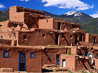
Taos Pueblo is an ancient pueblo belonging to a Taos-speaking (Tiwa) Native American tribe of Puebloan people. It lies about 1 mile (1.6 km) north of the modern city of Taos, New Mexico. The pueblos are considered to be one of the oldest continuously inhabited communities in the United States. This has been designated a UNESCO World Heritage Site.

Taos is a town in Taos County in the north-central region of New Mexico in the Sangre de Cristo Mountains. Initially founded in 1615, it was intermittently occupied until its formal establishment in 1795 by Nuevo México Governor Fernando Chacón to act as fortified plaza and trading outpost for the neighboring Native American Taos Pueblo and Hispano communities, including Ranchos de Taos, Cañon, Taos Canyon, Ranchitos, El Prado, and Arroyo Seco. The town was incorporated in 1934. As of the 2010 census, its population was 5,716.

Santa Clara Pueblo ″Singing Water Village″, also known as ″Village of Wild Roses″ is a census-designated place (CDP) in Rio Arriba County, New Mexico, United States and a federally recognized tribe of Native American Pueblo people. Santa Clara Pueblo was established circa 1550.

In the Southwestern United States, Pueblo (capitalized) refers to the Native tribes of Puebloans having fixed-location communities with permanent buildings which also are called pueblos (lowercased). The Spanish explorers of northern New Spain used the term pueblo to refer to permanent indigenous towns they found in the region, mainly in New Mexico and parts of Arizona, in the former province of Nuevo México. This term continued to be used to describe the communities housed in apartment structures built of stone, adobe mud, and other local material. The structures were usually multi-storied buildings surrounding an open plaza, with rooms accessible only through ladders raised/lowered by the inhabitants, thus protecting them from break-ins and unwanted guests. Larger pueblos were occupied by hundreds to thousands of Puebloan people. Various federally recognized tribes have traditionally resided in pueblos of such design. Later Pueblo Deco and modern Pueblo Revival architecture, which mixes elements of traditional Pueblo and Hispano design, has continued to be a popular architectural style in New Mexico. The term is now part of the proper name of some historical sites, such as Acoma Pueblo.

The Pueblo Revolt of 1680, also known as Popé's Rebellion or Popay's Rebellion, was an uprising of most of the indigenous Pueblo people against the Spanish colonizers in the province of Santa Fe de Nuevo México, larger than present-day New Mexico. The Pueblo Revolt killed 400 Spaniards and drove the remaining 2,000 settlers out of the province. The Spaniards reconquered New Mexico twelve years later.

Bandelier National Monument is a 33,677-acre (13,629 ha) United States National Monument near Los Alamos in Sandoval and Los Alamos counties, New Mexico. The monument preserves the homes and territory of the Ancestral Puebloans of a later era in the Southwest. Most of the pueblo structures date to two eras, dating between 1150 and 1600 AD.

The Santa Fe Trail was a 19th-century route through central North America that connected Franklin, Missouri, with Santa Fe, New Mexico. Pioneered in 1821 by William Becknell, who departed from the Boonslick region along the Missouri River, the trail served as a vital commercial highway until 1880, when the railroad arrived in Santa Fe. Santa Fe was near the end of El Camino Real de Tierra Adentro, which carried trade from Mexico City.
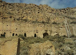
The Puye Cliff Dwellings are the ruins of an abandoned pueblo, located in Santa Clara Canyon on Santa Clara Pueblo land near Española, New Mexico. The site was declared a National Historic Landmark in 1966.

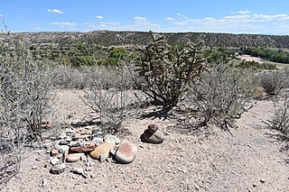
Pecos National Historical Park is a United States National Historical Park in San Miguel and Santa Fe Counties, New Mexico. The park, operated by the National Park Service, encompasses thousands of acres of landscape infused with historical elements from prehistoric archaeological ruins to 19th-century ranches, to a battlefield of the American Civil War. Its largest single feature is Pecos Pueblo also known as Cicuye Pueblo, a Native American community abandoned in historic times. First a state monument in 1935, it was made Pecos National Monument in 1965, and greatly enlarged and renamed in 1990. Two sites within the park, the pueblo and the Glorieta Pass Battlefield, are National Historic Landmarks.

Northern New Mexico in cultural terms usually refers to the area of heavy-Spanish settlement in the north-central part of New Mexico. However, New Mexico state government also uses the term to mean the northwest and north central, but to exclude both the northeastern high plains counties and Sandoval County. The five largest cities in Northern New Mexico are: Santa Fe, Las Vegas, Española, Los Alamos, and Raton.

Carson National Forest is a national forest in northern New Mexico, United States. It encompasses 6,070 square kilometers and is administered by the United States Forest Service. The Forest Service's "mixed use" policy allows for its use for recreation, grazing, and resource extraction.
New Mexico State Road 4 (NM 4) is a 67.946-mile-long (109.348 km) state highway in Sandoval, Los Alamos, and Santa Fe counties in New Mexico, United States. It is significant as the main access route connecting the remote town of Los Alamos, Los Alamos National Laboratory, and Bandelier National Monument to other, more major highways in New Mexico.
The following is an alphabetical list of articles related to the U.S. state of New Mexico.

San Gabriel de Yungue-Ouinge, or San Gabriel de Yunque, was the site of the first Spanish capital of its provincial territory of Santa Fe de Nuevo México. It is located where the Rio Chama meets the Rio Grande, west of present-day Ohkay Owingeh, New Mexico. The pueblo of Yuque Yunque was taken by Juan de Oñate, and he founded his colonial government there. It was moved to Santa Fe in 1610. The site was declared a National Historic Landmark in 1964. The archaeological site was leveled and plowed over in 1984, and a historical marker has been placed on the west side of the Rio Grande, off the old New Mexico State Road 74.
The 56-mile (90 km) High Road to Taos is a scenic, winding road through the Sangre de Cristo Mountains between Santa Fe and Taos.. It winds through high desert, mountains, forests, small farms, and tiny Spanish Land Grant villages and Pueblo Indian villages. Scattered along the way are the galleries and studios of traditional artisans and artists drawn by the natural beauty. It has been recognized by the state of New Mexico as an official Scenic Byway.

The Trail of the Ancients National Scenic and Historic Byway is a National Scenic Byway located in the U.S. states of Colorado and Utah. The route highlights the archaeological and cultural history of southwestern Native American peoples, and traverses the widely diverse geological landscape of the Four Corners region of the Colorado Plateau. It was the first National Scenic Byway that was designated solely for its archaeological sites. The entire route is approximately 480 miles (772.5 km) long.

The Rio Grande del Norte National Monument is an approximately 242,555-acre (98,159 ha) area of public lands in Taos County, New Mexico, proclaimed as a national monument on March 25, 2013, by President Barack Obama under the provisions of the Antiquities Act. It consists of the Rio Grande Gorge and surrounding lands, managed by the Bureau of Land Management (BLM).
The Enchanted Circle Scenic Byway is a New Mexico Scenic Byway and National Forest Scenic Byway located in Northern New Mexico. It begins and ends in Taos, New Mexico.
Posi-ouinge is an archeological site in Rio Arriba County, New Mexico and Taos County, New Mexico near Ojo Caliente. It was listed on the National Register of Historic Places in 1993 for its information potential.


