
Lyme Park is a large estate south of Disley, Cheshire, England, managed by the National Trust and consisting of a mansion house surrounded by formal gardens and a deer park in the Peak District National Park. The house is the largest in Cheshire, and is recorded in the National Heritage List for England as a designated Grade I listed building.

Hallamshire is the historical name for an area of South Yorkshire, England, approximating to the current City of Sheffield local government area.
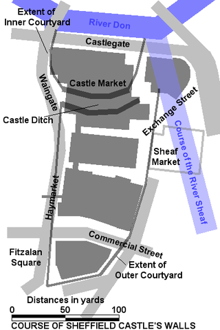
Sheffield Castle was a castle in Sheffield, England, constructed at the confluence of the River Sheaf and the River Don, possibly on the site of a former Anglo-Saxon long house, and dominating the early town. A motte and bailey castle had been constructed on the site at some time in the century following the Norman Conquest of England in 1066. This was destroyed in the Second Barons' War. Construction of a second castle, this time in stone, began four years later in 1270.

Darnall ward—which includes the districts of Attercliffe, Carbrook, Darnall, Tinsley, and parts of Handsworth—is one of the 28 electoral wards in City of Sheffield, South Yorkshire, England. It is located in the eastern part of the city and covers an area of 17.4 km2. The population of this ward in 2011 was 23,489 people in 8,809 households. It is one of the wards that made up the Sheffield Attercliffe constituency, now the Sheffield South East constituency.
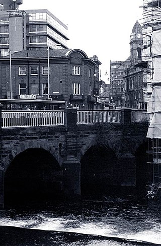
Lady's Bridge is the oldest bridge across the River Don in the City of Sheffield, England. It is located in the central section of the city, linking the Wicker to the north with Waingate to the south.
Beauchief and Greenhill ward—which includes the districts of Batemoor, Beauchief, Chancet Wood, Greenhill, Jordanthorpe, Lowedges and Meadowhead—is one of the 28 electoral wards in the City of Sheffield, England. It is in the southern part of the city and covers an area of 2.4 square miles (6.2 km2). The population of the ward in 2016 was estimated to be 19,669 people in 9,209 houses.
The history of Sheffield, a city in South Yorkshire, England, can be traced back to the founding of a settlement in a clearing beside the River Sheaf in the second half of the 1st millennium AD. The area now known as Sheffield had seen human occupation since at least the last ice age, but significant growth in the settlements that are now incorporated into the city did not occur until the Industrial Revolution.

The Old Queen's Head is a pub at 14 Pond Hill, Sheffield, South Yorkshire, England. It is a 15th-century timber framed building and the oldest surviving domestic building in Sheffield. It is now Grade II* listed.
Cutlers' Hall is a Grade II* listed building in Sheffield, England, that is the headquarters of the Company of Cutlers in Hallamshire. It is located on Church Street, opposite Sheffield Cathedral, in Sheffield City Centre.
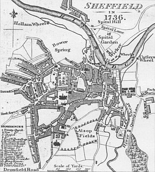
This timeline of Sheffield history summarises key events in the history of Sheffield, a city in England. The origins of the city can be traced back to the founding of a settlement in a clearing beside the River Sheaf in the second half of the 1st millennium AD. The area had seen human occupation since at least the last ice age, but significant growth in the settlements that are now incorporated into the city did not occur until the industrial revolution.
Barker's Pool is a public city square and street in the centre of Sheffield, England. The focus of Barker's Pool is the Grade II* listed 90-foot-tall (27 m) war memorial that was unveiled on 28 October 1925 to commemorate the First World War. The Grade II* listed Sheffield City Hall is on the north side of the plaza facing the Grade II listed former John Lewis & Partners department store.
Broom Hall is a historic house in the City of Sheffield, England that gives its name to the surrounding Broomhall district of the city. The earliest part of the house is timber-framed; it has been tree-ring dated to c1498, and was built by the de Wickersley family, whose ancestral home was at Wickersley. The de Wickersley family descended from Richard FitzTurgis, who co-founded Roche Abbey in South Yorkshire. The de Wickersley family later dropped their Norman name (FitzTurgis) in favour of the village they controlled.
All Saints is a Church of England parish church in Sheffield, England. It is a Grade II listed building, and is located in Ecclesall, between Ringinglow Road and Ecclesall Road South. All Saints' emergent youth and young adults congregation is called "The Uncut Project".

The Church of St Mary, Ecclesfield, is situated on Church Street in the village of Ecclesfield, Sheffield, South Yorkshire, England. It is situated 4.3 miles (7 km) north of the city centre. It is a Grade I listed building, one of only five within the Sheffield city boundary. It was originally the parish church for Hallamshire, one of the largest parishes in England and in the seventeenth century was known as the “Minster of the Moors” due to its then rural situation.
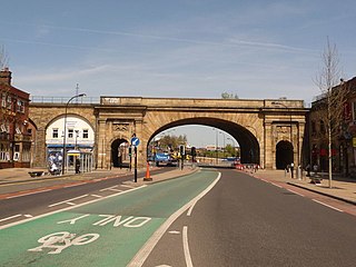
The Wicker is an arterial street in Sheffield, England noted for its history and viaduct that crosses it, the Grade II* listed Wicker Arches. It runs in a north-east to south-westerly direction between Lady's Bridge and the Wicker Arches. For many years the Wicker was an A road, but it has been downgraded following the opening of the Sheffield Northern Relief Road.

Carbrook is an industrial area of Sheffield, South Yorkshire, England to the south-east of Brightside. The suburb is named for the Carr Brook, which ran through the area until the late eighteenth century.

Endcliffe Hall is a 19th-century, 36-room mansion situated on Endcliffe Vale Road in the City of Sheffield in the suburb of Endcliffe. The hall is situated just over 2 miles (3.2 km) west of the city centre and is a Grade II* Listed building.

Banner Cross Hall is an English country house situated on Ecclesall Road South in the Banner Cross area of Sheffield, England. The hall is a Grade II listed building which is now the main headquarters of Henry Boot PLC, the Sheffield-based property and construction company.
Whirlow Hall Farm is a working farm situated on Broad Elms Lane at Whirlow in the City of Sheffield, England. Since 1979 it has been the site of the Whirlow Hall Farm Trust, a registered charity which allows children and young people to visit a working farm. The site includes various Grade II listed buildings including Whirlow Farmhouse built on the site of the old Whirlow Hall. In the yard below the farmhouse is Whirlow Hall Cottage along with two ancient cruck barns and a cow shed.

Broomhead Hall was a large English country house that stood in the Ewden valley, to the west of Sheffield, England. The hall stood near the hamlet of Wigtwizzle, to the west of Broomhead Reservoir.

