Sandgate is a village in the Folkestone and Hythe Urban Area in the Folkestone and Hythe district of Kent, England. It had a population of 4,225 at the 2001 census. It is the site of Sandgate Castle, a Device Fort. H.G. Wells lived at Spade House, and it is also the birthplace of comedian Hattie Jacques. Sandgate is the location of the Shorncliffe Redoubt, a Napoleonic-era earthwork fort associated with Sir John Moore and the 95th Regiment of Foot, known as the 95th Rifles. St Paul's Church lies next to the Saga building, which is built on the site of Enbrook House.

A civil parish in England is the lowest unit of local government. There are 284 civil parishes in the ceremonial county of Cumbria, with most of the county being parished. At the 2001 census, there were 359,692 people living in those 284 parishes, accounting for 73.8 per cent of the county's population.

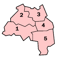
A civil parish is a country subdivision, forming the lowest unit of local government in England. There are 125 civil parishes in the ceremonial county of Bedfordshire, most of the county being parished: Luton is completely unparished; Central Bedfordshire is entirely parished. At the 2001 census, there were 312,301 people living in the 125 parishes, which accounted for 55.2 per cent of the county's population.

A civil parish is a country subdivision, forming the lowest unit of local government in England. There are 104 civil parishes in the ceremonial county of Berkshire, most of the county being parished; Reading is completely unparished; Bracknell Forest, West Berkshire and Wokingham are entirely parished. At the 2001 census, there were 483,882 people living in the 104 parishes, accounting for 60.5 per cent of the county's population.

A civil parish is a country subdivision, forming the lowest unit of local government in England. There are 264 civil parishes in the ceremonial county of Cambridgeshire, most of the county being parished; Cambridge is completely unparished; Fenland, East Cambridgeshire, South Cambridgeshire and Huntingdonshire are entirely parished. At the 2001 census, there were 497,820 people living in the parishes, accounting for 70.2 per cent of the county's population.

A civil parish is a country subdivision, forming the lowest unit of local government in England. There are 333 civil parishes in the ceremonial county of Cheshire, most of the county being parished. Cheshire East unitary authority is entirely parished. At the 2001 census, there were 565,259 people living in 332 parishes, accounting for 57.5 per cent of the county's population.

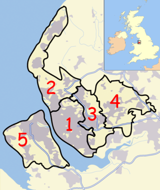
A civil parish is a country subdivision, forming the lowest unit of local government in England. There are 14 civil parishes in the ceremonial county of Greater Manchester, most of the county being unparished; Bury, Rochdale, Salford and Stockport are completely unparished. At the 2001 census, there were 129,325 people living in the civil parishes, accounting for 5.2% of the county's population.
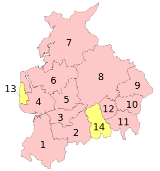
A civil parish is a subnational entity, forming the lowest unit of local government in England. There are 219 civil parishes in the ceremonial county of Lancashire; Blackpool is completely unparished; Pendle and Ribble Valley are entirely parished. At the 2001 census, there were 587,074 people living in the 219 parishes, accounting for 41.5 per cent of the county's population.

A civil parish is a subnational entity, forming the lowest unit of local government in England. There are 101 civil parishes in the ceremonial county of West Yorkshire, most of the county being unparished. At the 2001 census, there were 557,369 people living in the parishes, accounting for 26.8 per cent of the county's population.

A civil parish is a country subdivision, forming the lowest unit of local government in England. There are 94 civil parishes in the ceremonial county of South Yorkshire, most of the county being unparished. At the 2001 census, there were 360,191 people living in the parishes, increasing to 369,220 in 2011, accounting for 27.5 per cent of the county's population.

A civil parish is a subnational entity, forming the lowest unit of local government in England. There are 21 civil parishes in the ceremonial county of West Midlands, most of the county being unparished; Dudley, Sandwell, Walsall and Wolverhampton are completely unparished. At the 2001 census, there were 89,621 people living in the parishes, accounting for 3.5 per cent of the county's population.
A civil parish is a country subdivision, forming the lowest unit of local government in England. There are 22 civil parishes in the ceremonial county of Merseyside, most of the county being unparished; Liverpool and Wirral are completely unparished. At the 2001 census, there were 177,663 people living in the parishes, accounting for 13.0 per cent of the county's population.

Queensbury is a village in the metropolitan borough of Bradford, West Yorkshire, England. Perched on a high vantage point above Halifax, Clayton and Thornton and overlooking Bradford, Queensbury is one of the highest parishes in England, with views beyond the West Yorkshire conurbation to the hills of Brontë Country and the Yorkshire Dales to the north and north west. Its population of 8,718 in 2001 increased to 16,273 in the 2011 Census.
Abram is a village and electoral ward in the Metropolitan Borough of Wigan, Greater Manchester, England. It lies on flat land on the northeast bank of the Leeds and Liverpool Canal, 2 miles (3.2 km) west of Leigh, 3 miles (4.8 km) southeast of Wigan, and 14.5 miles (23 km) west of Manchester. Abram is a dormitory village with a population of 9,855.
Bentley with Arksey is a former civil parish (1866–1974) and urban district (1911–1974) adjacent to the town of Doncaster in the West Riding of Yorkshire.
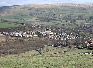
Dobcross is a village in the civil parish of Saddleworth in the Metropolitan Borough of Oldham in Greater Manchester, England. It is in a valley in the South Pennines, along the course of the River Tame and the Huddersfield Narrow Canal, 4.2 miles (6.8 km) east-northeast of Oldham and 13 miles (21 km) west-southwest of Huddersfield.

The Milton Keynes urban area or Milton Keynes Built-up Area is a designation established by the United Kingdom's Office for National Statistics. Milton Keynes has no statutory boundary: the 1967 designated area only determined the area assigned to the Milton Keynes Development Corporation for development. The wider urban area outside that designation includes Newport Pagnell and Woburn Sands as well as Aspley Guise (Bedfordshire) and part of Stoke Hammond civil parish.

A civil parish is a country subdivision, forming the lowest unit of local government in England. There are 218 civil parishes in the ceremonial county of Cornwall, which includes the Isles of Scilly. The county is effectively parished in its entirety; only the unpopulated Wolf Rock is unparished. At the 2001 census, there were 501,267 people living in the current parishes, accounting for the whole of the county's population. The final unparished areas of mainland Cornwall, around St Austell, were parished on 1 April 2009 to coincide with the structural changes to local government in England.