The Kolomoki Mounds is one of the largest and earliest Woodland period earthwork mound complexes in the Southeastern United States and is the largest in Georgia. Constructed from 350CE to 600CE, the mound complex is located in southwest Georgia, in present-day Early County near the Chattahoochee River.
Jaketown Site is an archaeological site with two prehistoric earthwork mounds in Humphreys County, Mississippi, United States. While the mounds have not been excavated, distinctive pottery shards found in the area lead scholars to date the mounds' construction and use to the Mississippian culture period, roughly 1100 CE to 1500 CE.

Marksville Prehistoric Indian Site, also known as the Marksville site, is a Marksville culture archaeological site located 1 mile (1.6 km) southeast of Marksville in Avoyelles Parish, Louisiana. The site features numerous earthworks built by the prehistoric indigenous peoples of southeastern North America.

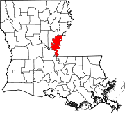
Coles Creek culture is a Late Woodland archaeological culture in the Lower Mississippi valley in the Southeastern Woodlands. It followed the Troyville culture. The period marks a significant change in the cultural history of the area. Population increased dramatically and there is strong evidence of a growing cultural and political complexity, especially by the end of the Coles Creek sequence. Although many of the classic traits of chiefdom societies are not yet manifested, by 1000 CE the formation of simple elite polities had begun. Coles Creek sites are found in Arkansas, Louisiana, and Mississippi. It is considered ancestral to the Plaquemine culture.

The Medora site (16WBR1) is an archaeological site that is a type site for the prehistoric Plaquemine culture period. The name for the culture is taken from the proximity of Medora to the town of Plaquemine, Louisiana. The site is in West Baton Rouge Parish, Louisiana, and was inhabited from approximately 1300 to 1600 CE. It consisted of two mounds separated by a plaza. In the winter of 1939-40 excavation of this site was undertaken by the Louisiana State Archaeological Survey, a joint project of Louisiana State University and the Work Projects Administration. It was directed by James A. Ford, and George I. Quimby. The excavations of the site were instrumental in defining the characteristics of the Plaquemine period and culture.

The Marksville culture was an archaeological culture in the lower Lower Mississippi valley, Yazoo valley, and Tensas valley areas of present-day Louisiana, Mississippi, Arkansas, and extended eastward along the Gulf Coast to the Mobile Bay area, from 100 BCE to 400 CE. This culture takes its name from the Marksville Prehistoric Indian Site in Avoyelles Parish, Louisiana. Marksville Culture was contemporaneous with the Hopewell cultures within present-day Ohio and Illinois. It evolved from the earlier Tchefuncte culture and into the Baytown and Troyville cultures, and later the Coles Creek and Plum Bayou cultures. It is considered ancestral to the historic Natchez and Taensa peoples.

Poverty Point State Historic Site/Poverty Point National Monument is a prehistoric earthwork constructed by the Poverty Point culture, located in present-day northeastern Louisiana. Evidence of the Poverty Point culture extends throughout much of the Southeastern Woodlands of the Southern United States. The culture extended 100 miles (160 km) across the Mississippi Delta and south to the Gulf Coast.

Frogmore Mound Site is an archaeological site of the Late Coles Creek culture in Concordia Parish, Louisiana. The site is located 7 miles (11 km) west of Ferriday on US 84. It was added to the National Register of Historic Places on July 28, 2004.

Peck Mounds is an archaeological site of the Late Troyville-Early Coles Creek culture in Catahoula Parish, Louisiana.
The Ghost site, or Ghost site mounds is an archaeological site in Tensas Parish, Louisiana, with an early to middle Coles Creek culture component and a Late Coles Creek to Plaquemine culture component.
Scott Place Mounds is an archaeological site in Union Parish, Louisiana from the Late Coles Creek-Early Plaquemine period, dating to approximately 1200 CE. The site is one of the few such sites in north-central Louisiana.
Venable Mound is an archaeological site in Morehouse Parish, Louisiana with a single mound with components from the Troyville, Coles Creek and Plaquemine period.
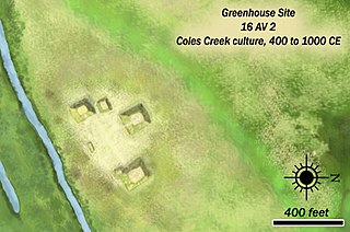
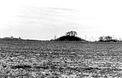
The Greenhouse site is an archaeological site of the Troyville-Coles Creek culture in Avoyelles Parish, Louisiana.

Troyville Earthworks is a Woodland period Native American archaeological site with components dating from 100 BCE to 700 CE during the Baytown to the Troyville-Coles Creek periods. It once had the tallest mound in Louisiana at 82 feet (25 m) in height. It is located in Catahoula Parish, Louisiana in the town of Jonesville. The site is the type site for the Troyville culture of the lower Ouachita and Tensas River valleys. Before it was destroyed for bridge approach fill in 1931, the main mound at Troyville was one of the tallest in North America.
Sundown Mounds is a multimound archaeological site in Tensas Parish, Louisiana from the Early Coles Creek culture. It is the type site for the Sundown Phase of the Tensas Basin and Natchez Bluff Coles Creek chronology.
Marsden Mounds is an archaeological site with components from the Poverty Point culture and the Troyville-Coles Creek period. It is located in Richland Parish, Louisiana, near Delhi. It was added to the NRHP on August 4, 2004, as NRIS number 04000803. It is the type site for the Marsden Phase of the Tensas Basin and Natchez Bluff regions local chronology.
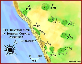
The Baytown Site is a Pre-Columbian Native American archaeological site located on the White River at Indian Bay, in Monroe County, Arkansas. It was first inhabited by peoples of the Baytown culture and later briefly by peoples of the Plum Bayou culture, in a time known as the Late Woodland period. It is considered the type site of the Baytown culture.
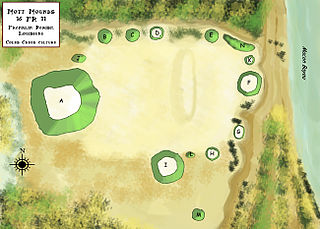
The Mott Archaeological Preserve or Mott Mounds Site is an archaeological site in Franklin Parish, Louisiana on the west bank of Bayou Macon. It originally had eleven mounds with components from the Marksville, Troyville, Coles Creek, and Plaquemine periods. It was at one time one of the largest mound centers in the Southeast and has one of the largest mounds in Louisiana with a base which cover more than two acres. It was purchased by the Archaeological Conservancy in 2002. and is now used for research and educational purposes.

Bayou Grande Cheniere Mounds is an archaeological site in Plaquemines Parish near the southeast corner of Louisiana. Built by the Coastal Coles Creek culture, it was inhabited from 875 to 1200 CE, from the Early Coles Creek period to the Coles Creek/Plaquemine period.
The Atchafalaya Basin Mounds is an archaeological site originally occupied by peoples of the Coastal Coles Creek and Plaquemine cultures beginning around 980 CE, and by their presumed historic period descendants, the Chitimacha, during the 18th century. It is located in St. Mary Parish, Louisiana on the northern bank of Bayou Teche at its confluence with the Lower Atchafalaya River. It consists of several earthen platform mounds and a shell midden situated around a central plaza. The site was visited by Clarence Bloomfield Moore in 1913.